This hike to Mary’s Rock starts from Jewell Hollow. The route follows the Appalachian Trail for roughly three miles to Mary’s Rock. After spending some time enjoying the views, simply retrace your steps back to Jewell Hollow for a total hike of roughly six miles. There are other ways to reach the summit, but in our opinion, this route offers the best scenery and the most pleasant trail conditions.

Adam Says…
Mary’s Rock is a great view hike on the Appalachian Trail. There are many theories on how the summit got its name, but my favorite one is that Francis Thornton’s daughter Mary climbed up to the rock and came back down carrying a bear cub under each arm. Francis Thornton III owned a lot of land to the east of the Blue Ridge Mountains and Thornton Gap is named for him.
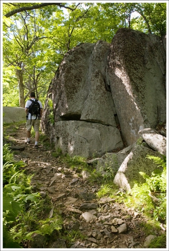
We have hiked to Mary’s Rock numerous times in the traditional way, from the trailhead at Panorama, but the trail from Jewell Hollow is not one to be missed. In my opinion, this is definitely one of the best hikes to do in the park for scenery. In the fall, you will be able to see great colorful views looking into the western valley below.
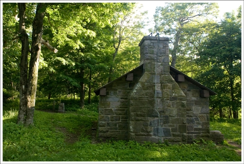
The trail is probably roughest during the first .75 miles, but then the rocks tend to give way to easier footing. There are great places to take in the views at .85 miles at the Pinnacle and at another overlook at 2.0 miles. You will also pass a AT hiker hut (Byrd’s Nest #3) about halfway through the trip.

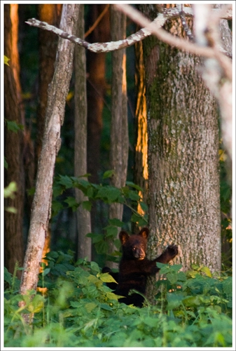
Despite the fact that we had to rush to make it back to the car by sunset, we really enjoyed this trail. We saw a bear on the trail going up and probably the same one again coming back. On the way back, I was probably only 75 feet away when the bear crossed our path, but he quickly took off as soon as he realized we were nearby. We also encountered two large bucks on the trail, too. When we saw the first one, we were coming downhill and it appeared that the buck wanted to stand his ground and approach us. So, we yelled at him and shooed him back into the forest.
There is a geocache at the top of Mary’s Rock requiring you to identify dates on the USGS markers. You will have to climb up on the steep rocks to find them, but if you feel comfortable scrambling on rocks, this isn’t too tough.
- Mary’s Rock Geocache titled “At the Rock”
Christine Says…
What can I say… we didn’t do a very good job using the distance scale on our map for this hike! I would have sworn that our PATC map made the hike look like 3.5 – 4 miles total, rather than the 6 miles it actually turned out to be. Normally, that wouldn’t be a big deal, but we didn’t start walking until 5:45 p.m.
This was the first time we’ve accessed Mary’s Rock via the Appalachian Trail. In the past, we’ve always gone by-the-book, and followed the designated Mary’s Rock trail. That trail begins at the Panorama parking lot, and makes its way up the mountain via a series of switchbacks. The Mary’s Rock trail is fine, but it’s really quite boring in way of scenery and views. The hike we did along the AT is longer, but it’s also flatter and tremendously more scenic.

The trail we hiked primarily follows the ridgeline, making one dip down through a saddle between the mountains. The trail is lined with ferns, mountain laurels and rhododendrons. There are many truck-sized boulders along the trail. They kind of look like graveyard headstones for giants. At the .85 mile mark, hikers are treated to an absolutely spectacular view from the Pinnacles, which is the highest point in Rappahannock County. The craggy, boulder-strewn mountains sweep down into the valley, hawks soar below and you get a nice look at Mary’s Rock way off in the distance. As I was enjoying the Pinnacles view, I said to Adam “You know… Mary’s Rock still looks pretty far off. Are you sure we got the distance right? We’re not going to be hiking back in the dark, are we?” He responded “Nah, we’re fine! You need to trust my map reading skills.”
A while later, we passed the Byrd’s Nest #3 Shelter, which was close to the halfway point of the walk up to Mary’s Rock. Time was passing quickly, and I was getting the distinct feeling that the hike was longer than the mileage we estimated. I started to get a bit squirrely at this point. We didn’t have headlamps or a flashlight, and I seriously did not want to get stuck out on the trail after sun down. A lot of the trail’s footing is made up of loose rocky terrain that twists its way through dense mountain laurel thickets. Also, there was a bear lurking in the area – we had heard him crashing through the woods and seen his rounded ears peeking up through the brush.
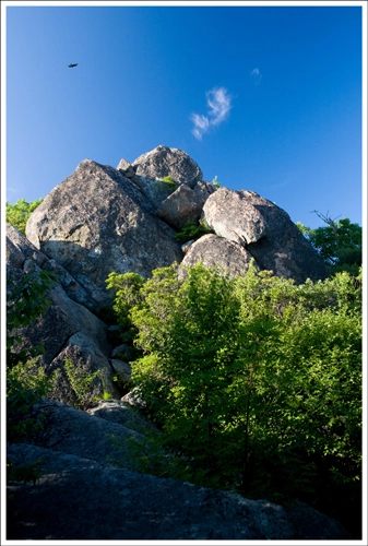
After passing the shelter, we started almost jogging the trail to make sure we’d have ample daylight for the return trip. We got to the summit around 7:20, just a little over an hour before sunset. Mary’s Rock is an impressive rock outcropping that overlooks both the Shenandoah Valley and a little bit of the eastern Piedmont. In the late afternoon, the light is so warm and lovely on the rock. We enjoyed the vista for a couple minutes, and then promptly began our return trip. Along the way back, we crossed paths with about a half dozen thru-hikers. Many of them were setting up camp at the Byrd’s Nest shelter. We hiked the entire return trip very quickly, and made it back to our car just about ten minutes before the sun set. As we stepped off the trail onto Skyline Drive, I noticed a bear with cubs in the woods on the other side of the road. It was nice to see the bear family as a grand finale for our hike.
Under normal, non-rushed circumstances, I’d have to say this is one of the prettiest and most pleasant hikes I’ve ever done in the park. I’d love to go back and re-hike it in the fall. I think the views along the way would offer some amazing places to photograph the fall foliage. And from now on, we’re not hiking anything over three miles in the evening.
Trail Notes
- Distance – 6 miles total, out-and-back
(Check out the stats from MapMyHike)*
- Elevation Change – About 800 ft.
- Difficulty – 2. Nice and mostly level, with only a few very moderate climbs.
- Trail Conditions – 3. There are some loose and pointy rocks along several sections of the trail. If you don’t pay attention, this trail can be an ankle-turner. But overall the trail is smooth and well-maintained.
- Views – 4. On a clear day – the views are amazing!
- Waterfalls/streams – 0. Non-existent
- Wildlife – 5. Bears, bucks, chipmunks, rabbits, squirrels and many species of birds. It was a great trail to see animals.
- Ease to Navigate – 4. After a very brief walk on the Leading Ridge trail, you follow the AT all the way up to Mary’s Rock. You will not see signs for Mary’s Rock until the cement marker post at the Meadow Springs trail junction.
- Solitude – 3. You probably won’t see many hikers between Jewell Hollow and the Meadow Springs Trail junction (with the exception of AT hikers in June). However, the officially designated Mary’s Rock is very popular. It is likely you will see many people in the last mile before reaching Mary’s Rock.
Directions to trailhead: The trail is located on Skyline Drive at mile marker 37. Park at the Jewell Hollow Overlook. Walk 50 yards north on Skyline Drive. You’ll see a cement marker for the Leading Ridge trail on the west side of the drive. Follow the Leading Ridge trail for .1 of a mile to a junction with the AT. Turn right and proceed from there.
* MapMyHike is not necessarily accurate, as the GPS signal fades in and out – but it still provides some fun and interesting information.

Can people overnight at the summit, its ok to park overnight at the parking lot next to Marys Rock? if not would you recommend a trail to spend one night at the Shenandoah Im looking on the front royal side thanks
LikeLike
I would suggest camping at Byrd’s nest shelter which is about a mile or so south of the summit. You cannot camp on Mary’s Rock summit.
LikeLike
I was planning on trying this trail this coming weekend. Have a medium size dog I really want to take. Has anyone ever tried this with their pet?
LikeLike
If your dog is fit and active, they should be fine. The terrain is uncomplicated. I’ve taken my pug on this hike, but he’s super-fit compared to most pugs.
LikeLike
Thank you for this post. We did this hike yesterday. The leading ridge trail north of the parking lot is pretty overgrown with briars but the AT is easy to access at the south end of the parking lot. We also had our closest bear encounters ever in Shenandoah park so I was glad we were keeping the kids close.
LikeLike
I’m glad you enjoyed the hike and got to see bears! It’s been tough for volunteer trail maintainers to keep up with all the overgrowth with all the rain we’ve had!
LikeLike
Adam and Christine- Thanks for another great trail description. Jeanne and I are going to try to do a ‘double header’ with Mary’s Rock and Hazel Falls in one day. Your description helped us select a start point at the meadow spring parking area. Happy hiking.
Jim and Jeanne
LikeLike
Enjoyed hiking with my school age camp this week. The Child Care and Learning Center hiked Mary’s Rock on Friday and loved it!
LikeLike
Glad you had fun!
LikeLike
Just completed this hike and loved it! Not too steep and you get a mix of more wooden areas and walking along a ridge with views. Great for an autumn day. The way there was very easy and a few more hills on the way back. Took 3 hours including about a 30 minute break for views and lunch at the top. Very easy to follow the trails and find the parking lot. Great hike–highly recommend!
LikeLike
Glad you enjoyed!
LikeLike
Thanks for the alternate path to Mary’s Rock. Hiked it today and really enjoyed it. I agree it is a much more interesting hike than getting there via the old Panorama route. We’ve really expanded our hiking horizons via your website. Keep up the great work!
LikeLike
Thanks, Felix! Glad you enjoyed the route!
LikeLike
Is Mary’s Rock the same as Old Rag? They look like they are very close on the map, and I recall seeing a shelter that looks like the Byrd’s Nest on the Old Rag hike.
LikeLike
Hi Steve. No… Mary’s Rock and Old Rag are two different hikes. Old Rag is a strenuous hike/rock scramble, while Mary’s Rock is more of an easy walk. Both hikes do have backcountry shelters en route. The one on the way to Mary’s Rock is used by overnight, long-distance hikers. The shelter on Old Rag is day use only. Mary’s Rock is located west of Skyline Drive and overlooks the Page Valley. Old Rag is on the east side of the drive, near Sperryville.
LikeLike
I’m confused. It is 6.8 total to go from Jewell hollow or is it 6.8 both ways? You said you mapped wrong and it was actually a 7 mile hike?
LikeLike
Samantha – the TOTAL hike is just under 7 miles – roughly 3.4 miles there and 3.4 miles back. When I say we mapped it wrong, we thought it was more like a 4 mile (TOTAL) hike when we looked at it on a map.
LikeLike
Looks like a great trip. Maybe I’ll try it this weekend. I was just wondering how close you got the bear cub? I do quite a bit of hiking and still haven’t seen any bears on the east coast. Also, in all your pictures the sky is so blue. Are you using a filter?
LikeLike
We were across Skyline Drive from the cub, and I was shooting with a long telephoto. We see bears very frequently in the park, definitely more often than not! And yes… I usually use a circular polarizer when shooting blue skies. Thanks for the visit!
LikeLike
Hi
Me and my husband will be going there in a week. Does anyone know if there are any backcountry camping spots along the way?
Thanks!
Yoanna
LikeLike
Yes, Yoanna…The Byrd’s Nest backcountry shelter is right along the Appalachian Trail – just a couple miles from the Mary’s Rock summit. There are tent sites, a bear hang, a spring and a privy. Feel free to email virginiatrailschristine@gmail.com if you need more tips.
LikeLike
Thanks so much for responding! We will definitely be trying out this route over Memorial Day weekend! You have been a great help!
LikeLike
Olivia – My dad and I actually did the route you’re asking about as a father-daughter hike last year on Father’s Day. We met in the park, so we had two cars and it made sense to do a shuttle hike rather than an out-and-back. The hike from Mary’s Rock down to Panorama is pretty moderate – lots of switchbacks, not too steep, but very rocky. There won’t be any additional views between Mary’s Rock and Panorama.
And yes — the hike would be perfectly suitable for your dog. I would even feel confident taking my pug along this section of trail. 🙂
LikeLike
Hello,
I have never hiked to Mary’s Rock before, and I am very interested in your “alternate route” posted here for our trip in a few weeks. I was wondering if you might be able to weigh in on a question I have. My thought was to park a car at Panorama and then drive to Jewell Hollow, then hike to Panorama via Mary’s Rock. Are there any advantages/disadvantages to that? My thought was that it would be a bit shorter, but I am not sure if there are any good views on the Parnorama portion of the trail or if it is better to just retrace our steps to return. Please let me know what you think. Also, would this hike be suitable for an active dog who is familiar with hiking?
Thanks for your input,
Olivia
LikeLike
We just did this one, starting at the rest stop near Hwy 211. Absolutely wonderful hike but quite popular so you won’t be alone at the top. (There must have been about 20 people with us on 4/6/2012) Thanks for posting it or we would certainly have missed the opportunity. There is a rock up there that looks just like a bear lying down. After reading the story about the legend of this hike’s name we thought that maybe this was the mother looking for her two missing cubs :). I took a picture of it if you are interested.
LikeLike
Thanks for the visit, Martine! I would love to see the photo.
LikeLike
Has anyone done this trail during the winter? I will be close to Shenandoah this weekend and was wondering if it’s worth hiking there at this time of the year. Thanks.
LikeLike
This is one of the best trails to hike in winter, especially since you can hike it from outside the park when Skyline Drive is closed. Just start out right alongside the side of route 211 where you see the AT crossing. This route up to Mary’s Rock is a bit steeper than our route, but it’s not a hard hike. If Skyline Drive is open, you shouldn’t have any trouble hiking via our route.
LikeLike
Also, what time would you say is the ideal time to hike? Early morning? Afternoon? 🙂
LikeLike
I am planning on doing this hike…but I am unsure on how to get there. Would I drive to Shenandoah National Park first and then take the trail from there? This is my first time hiking in the Shenandoah. Please help! 🙂
LikeLike
I think the hike is nice both in the morning and afternoon, so it really doesn’t matter. If you hike in the afternoon, just make sure you have enough time to finish before dark (or bring a headlamp!). The trailhead for this hike is just about a tenth of a mile north of the Jewell Hollow Overlook and Pinnacles Picnic Area, so you will enter the park and follow Skyline Drive until you reach the trailhead.
LikeLike
Just wanted to say thanks for the great write-up! We did this hike the usual way last year (from the Panorama parking lot), so we were curious to try your approach this time. Your tips and descriptions were right on the money, and the hike itself was perfect: fewer people, great views (the fall colors were spectacular), etc.
I’m definitely bookmarking you guys for future hikes. Thanks again!
LikeLike
Thanks for visiting, Mags! I’m glad you liked our Mary’s Rock route. After hiking it that way, I don’t know that we’ll ever hike up from the Panorama lot again. Hiking over from Pinnacles gives you so many more views and nicer trail conditions.
LikeLike
My son and I made the trip from south central Pennsylvania on Friday, July 1st, 2011 to do this hike and to also do North and South Marshall peaks. We had quite a full day! We hike in SNP often and have found this hike to be one of the best ones we ever did in the park. We got a bit of a late start for this hike on purpose so the lighting for our photography would be optimum. It was. Just like you, we were rushing to get back to our car before sunset. The berry bushes along the first part of the trail provided an excellent opportunity for a snack. The only people we saw the entire day were two hikers at Byrd’s Nest #3. On the way back, we took some of the best sunset pictures ever. We are looking forward to doing this hike again in the fall when the trees offer their full color.
LikeLike
Thanks for the visit, Walt & Jonathan! That is a great vantage point for sunset, so I bet your photos are as spectacular as you described.
LikeLike
Hi:
I’m pretty sure I understood what you meant, but when you say “out and back” do you mean the entire trip was 13.6 miles? Planning my first trip to the Park and this sounded like a great hike, but of course I want to be as accurate as I can. Your entire website has been a great help. Thanks.
LikeLike
The miles for out-and-back represent the TOTAL miles for both the out and the back.
LikeLike
I’ll try to fit this in, it sounds like fun! Thanks for this resource, it helps a lot in planning my trip. A real lifesaver.
LikeLike
You’ll love this hike! It’s pleasant walking with fabulous views along the way.
LikeLike
Another hike to add to the list! Really enjoyed this entry guys! Thanks again!
LikeLike
This is definitely a hike worth doing, Jim! It’s not in any park guide books, but it’s on PATC maps.
LikeLike