NOTE: Parking at Edith Gap was greatly restricted starting in fall 2020. If you attempt to park there, be sure to pay attention to the the new ‘No Parking, Tow Away’ signs. Unless you are very certain you are legally parked, we suggest following the updated route outlined below, starting from the horse trailer parking area for the Stephens Trail about a mile lower on the mountain.
Kennedy Peak is an beautiful seven-mile out-and-back hike in the Lee District of George Washington National Forest. It gives hikers gorgeous views of the bends in the Shenandoah River.

Christine Says…
I love this hike. We’ve hiked it in winter and fall before, but this was the first time we’ve hiked it in the spring. Sunday afternoon was the kind of day that is custom made for hiking. It was dry, sunny, breezy and in the low 70’s. The trail was lined with brilliant, pink rhododendrons. All the trees were covered with new, spring green leaves and/or blossoms. Butterflies were fluttering all around the trail, taking pauses on the blooming trees and wildflowers. It was, in a word, idyllic.

We began in the Stephens Trail/horse trailer parking area on VA675. The Stephens Trail departs from the back of the parking area. You should look for the orange-blazed Massanutten Trail at the head of the parking lot. The trail climbs moderately uphill for .9 miles. At the top of the climb, you’ll exit onto VA675 at Edith Gap (the old parking area). On the road, take a sharp left, staying on the orange-blazed Massanutten Trail.
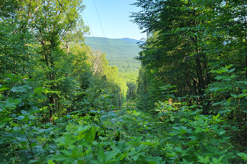
The part of the trail starts off as a wide, almost road-like track. This part of the hike is extremely easy – climbing just a couple hundred feet over the next 1.75 miles.
At around mile 2.65, the trail takes a sharp, hairpin turn and begins to climb more steeply over increasingly rocky terrain. At this sharp switchback, you may be tempted to continue straight along a visible path, but be careful to make the turn and follow the orange blazes uphill. This slightly tricky misdirection has been blocked off by logs and rocks, but enough people have missed the turn that the false path remains well-trodden. We once followed it out of curiosity and it doesn’t lead anywhere. It eventually fades out into the forest.

After the switchback, the trail continues uphill for another half mile. There is a small outcropping on the left with a obstructed views and a tiny campsite (room for a hammock or a one-person tent). After you pass this spot, continue a couple tenths of a mile to the junction with the Stephens Trail. (Note: If you want to make a longer day, adding about two more miles to your route, you can descend back to your car via the Stephens Trail. We’ve heard it’s not very scenic and is often muddy and manure-covered, so we chose the out-and-back.)
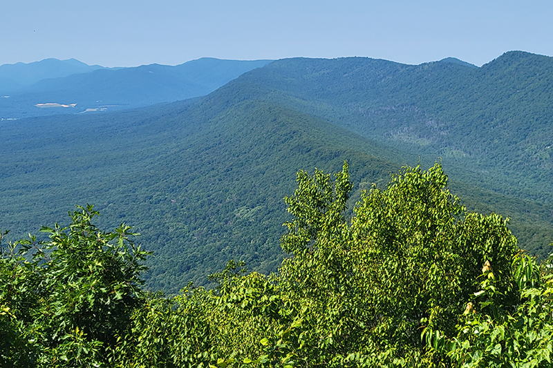
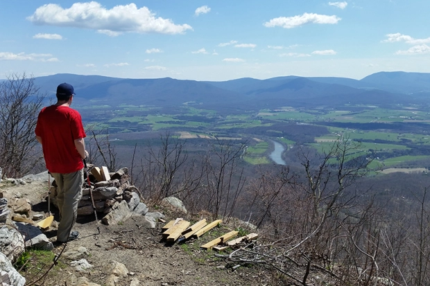
At the junction, you will turn right and follow the signs toward the fire tower. The tower is a little over .2 miles from the junction. The last stretch to the fire tower is steep and rocky. It’s really the only challenging section of the hike. The tower is a sturdy one-story structure with great views looking into the valley and Shenandoah National Park beyond.
When we got to the summit, we had the observation tower all to ourselves. We watched birds in the treetops, spotted lizards climbing around on the rocks and took in a fantastic view of the Shenandoah River and the Page Valley. It was one of the least hazy days we’ve had in a while, so we could clearly see Shenandoah National Park from this summit. Lots of vultures were soaring overhead, and even though they’re kind of creepy, they were casting cool bird-shaped shadows onto the mountain top. I always like it when they do that.

Sunday was the only time we’ve hiked Kennedy Peak in the afternoon. Adam and I tend to be morning hikers — it helps us avoid the crowds. But, the light is definitely prettier in the afternoon on Kennedy Peak. If you hike it in the morning, the sun shines right in your face at the summit. That makes it hard to appreciate the great view, and makes it nearly impossible to get any decent photos.
Adam Says…
This is one of our favorite hikes. This hike is not very steep and the payoff is wonderful. This is a good multi-use trail, since there are campsites and good footing for horses. There are a couple of campsites at the beginning of the trail, near the road. The nicest campsites are further up the trail. Once you are on the fire tower trail, you will find a couple of places where you can have some nice lookouts over the valley and the Shenandoah River. From some points, you can see several bends in the River. Once you reach the top, there is an observation tower where you can chill for a while before heading back down.
If you are into geocaching, look for the Presidential Peek Cache! After your hike, be sure to visit Camp Roosevelt – a great spot for a picnic.
Trail Notes
- Distance – 7 miles round-trip
- Elevation Change – 1300′
- Difficulty – 3. The trail for the first miles is moderately uphill. The next two miles are either flat or gentle rolling terrain. The last third of a mile up to the observation tower is steeper, but very manageable.
- Trail Conditions – 3. The trail is well-maintained, but there are a lot of rocks, so you’ll need to watch where you step.
- Views – 4. You can really see some nice views close to the top.
- Waterfalls/streams – 0. This trail is dry as a bone.
- Wildlife – 2. Seems like a great bird-watching area. We saw an Indigo Bunting, Goldfinch, Wood Thrush, and Eastern Towhee. Also spotted a box turtle and Eastern fence lizard. We saw a bear when we hiked it in spring 2017.
- Ease to Navigate – 4. Other than the one tricky spot at the switchback, it would be nearly impossible to get lost.
- Solitude – 2. This trail is well-loved by a lot of locals, but the bulk of area tourists stick to the trails in Shenandoah National Park. You may see a few groups of hikers along the way, but it’s rarely a crowded trail.
All Photos


Directions to trailhead: The parking lot is the Stephens Trailhead on VA675. Coordinates: 38.72795, -78.51536

I just hiked Kennedy Peak trail and got lost because of poor orange markings and a very misleading part of the switchback where if you keep going straight on a visible path it takes you deeper into the forest and farther off the trail. Apparently enough people have done this that a false trail has formed. This is very dangerous because if you keep going you will get more lost and have much difficulty getting back to the orange marked trail. We had to call search and rescue who plotted our latitude and longitude settings and told us which direction to go to get back onto the main trail. Be careful on the switchbacks and if you feel you’re off the trail, backtrack immediately.
LikeLike
I’m sorry to hear you got off track! I know exactly the spot where you went wrong and we do describe it in our post in hopes that people will pay attention to that sharp turn. So many people have done exactly the same thing you did.
This is what our post says: “At this point, the trail takes a sharp, hairpin turn and begins to climb more steeply over increasingly rocky terrain. At this sharp switchback, you may be tempted to continue straight along a visible path, but be careful to make the turn and follow the orange blazes uphill. This slightly tricky misdirection has been blocked off by logs and rocks, but enough people have missed the turn that the false path remains well-trodden. We once followed it out of curiosity and it doesn’t lead anywhere. It eventually fades out into the forest.“
LikeLike
Yes I’m glad you understand what happened to me. When I finally got back last night safely, I researched online if other hikers had the same issue out of curiosity which is when I came across your post along with many others. So that answered my question that it is a common problem that many others have also made. Hopefully someone can simply put an arrow there to direct people to turn left at the switchback and not keep going straight on the false trail and get lost. If I had read more about this before my hike I may have known better and not missed the turn, but not many people are going to research all that before they go on a hike. Thank you again for the reply and hopefully this problem can be solved so nobody else gets lost or worse.
LikeLike
Last October I took my daughters (seven and eight) on the trail and camped over night. It was cold but so much fun. We made the hike up to the Tower during the day and the view was really great. At night we camped at a campsite along the ridge trail leading to the tower and the stars in the sky were complimented by the lights in the valleys bordering the ridge. The hike itself was a perfect beginner hike. Not too steep, not too hard, short but with a big payoff at the end. It was a really great first time experience for my daughters and we will be back soon.
LikeLike
Sounds like you had a wonderful outing!
LikeLike
A most memorable hike on November 18, 2016. My wife and I encountered a flock of turkeys on the way to the Peak, had beautiful weather and a spectacular view, and watched a bear for several minutes on the way back. It stayed long enough for us to get several pictures, though we did not get any closer than about 60 yards.
LikeLike
That’s a GREAT wildlife day!
LikeLiked by 1 person
We climbed on horseback and it was a workout! The last portion of the trail is strewn with many rocks and narrow trail! It was fun and we truly believe it was the ride of a lifetime!
LikeLike
Thanks for the visit, Harry! I used to have an off-track Thoroughbred that LOVED to ride the trails. I miss him a lot and miss trailriding, too!
LikeLike
So excited to find this trial again, did it as a little girl around 7 years old. Looking forward to doing it again with my kids.
LikeLike
Kennedy is a great family hike, Mary!
LikeLike
Reblogged this on TebbCabin.
LikeLike
Christine,
I can’t wait to check out Kennedy Peak soon.
And the rest of this guide is spectacular. What a great resource!
LikeLike
You’ll love the hike, Maggie! It’s a beautiful walk with a big payoff view at the end.
LikeLike
Great work guys, this is going straight into my RSS reader! The content may not be immediately useful to me (until I retire and do the AT in about 30 years!), but I always enjoy Christine’s back-stories from her photos and it’s great to hear from Adam too! I love the WA shot inside the tower.
LikeLike
I guess I should throw some kudos to Adam, too! 🙂 (And maybe Wookie had a hand in the design or HTML???) Great stuff guys!
LikeLike
Thanks for visiting, Jeff! Wookie is most definitely a talented web developer. He has a MacBook in his crate and spends all day coding. 😉
LikeLike
Your blog is superb, Christine! If I lived near you, I would definitely be using it as a trail resource. Fantastic info and (of course) great photos. Love that little splash of blue on the indigo bunting. Keep up the great work!
LikeLike
Nice report and thanks for the directions!
You guys rock!
LikeLike
Thanks, Jim! We’re going to be adding some West Virginia trails for the site, too.
LikeLike
Looking forward to that! I know it will be awesome…
LikeLike