Mt. Cardigan (NH)

Special: New Hampshire Edition

Introductory Guide to Visiting the White Mountains

This moderate 3.3 mile hike takes you to the summit of a beautiful,  bare mountaintop complete with a fire tower.  Views from the summit look across three states.

View the Full Album of Photos From This Hike

Views from the Summit of Cardigan
Even though Cardigan is a small mountain by New Hampshire standards, it still offers dramatic views. Below:  Adam begins the ascent of the West Ridge Trail; Trees give way to open rock;  Cairns mark the way across the rocky mountain top.

Trailhead of Cardigan West Ridge Opening Views on Cardigan Cairns as Trail Markers

Christine Says…

Standing at just 3,155 feet, Cardigan is a diminutive mountain compared to many of its neighbors. Though it lacks in elevation, it still offers a bald, rocky summit and panoramic views that allow you to look across New Hampshire and into both Maine and Vermont.

We thought it would be a great first hike on our trip – kind of a White Mountain warm-up.   We were still pretty tired from the 12-hour drive up, but we set out early Sunday morning.  We arrived at the parking lot in Cardigan State Park and found only a few other cars, despite the day being sunny and pleasant.

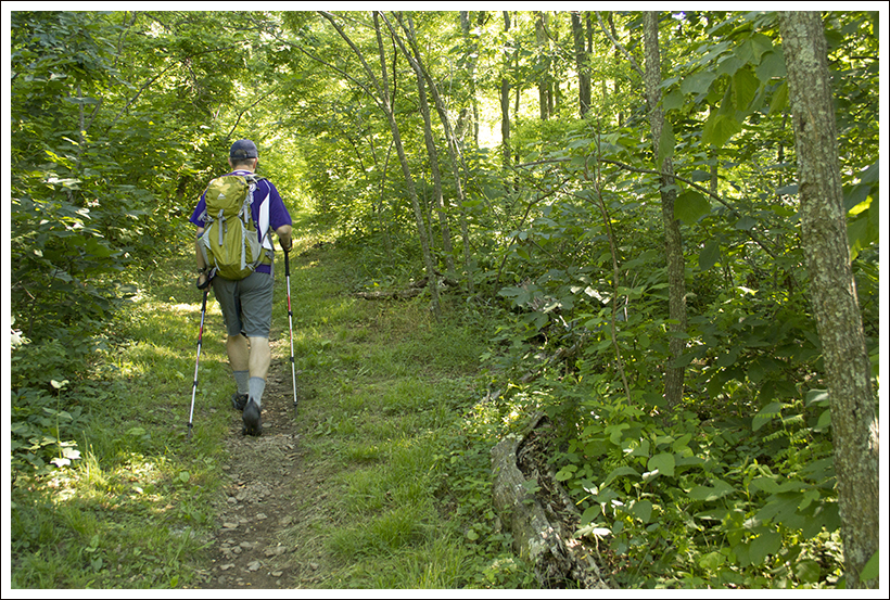
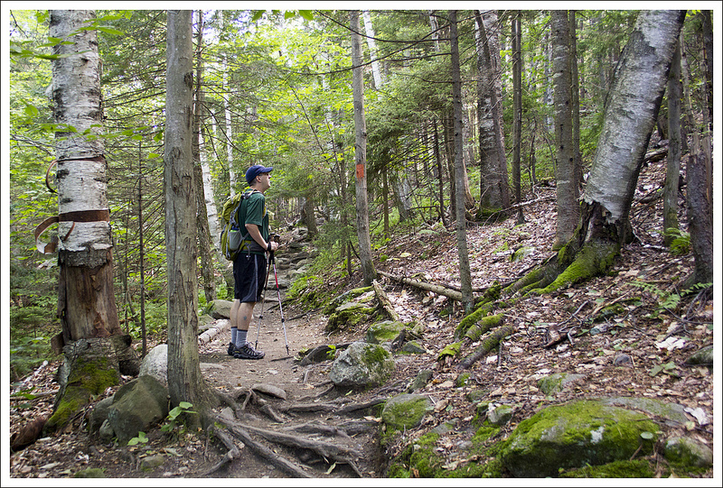
There are several routes up Cardigan.  We chose the ascent recommended by the Darmouth Outing Club, the West Ridge Trail, which climbs 1200 feet over 1.5 miles to the summit.  The trail started out behind a small picnic shelter.  It climbed quickly uphill through classic New England forest – lots of pines and white birches.  As we climbed higher, we traversed several small streams and muddy areas on small footbridges and planks.  There was even one tiny waterfall cascading over a slide of smooth rock.

Rough Terrain on Cardigan
Most New Hampshire mountain trail require negotiating rocks, roots and mud. Below: Classic New England woods – pines and birches; Adam crosses a plank over a muddy area; Our first open views on the trail.

Birches and Pines Crossing Mud First Open Views on Cardigan

After the junction with the Skyland Trail, we continued up the West Ridge on increasingly steep and rocky terrain.  Soon the trees gave way to a smooth rock dome, and instead of orange blazes the route was marked by cairns (pyramid-shaped piles of rocks).  Every time we paused, we took a moment to gaze backwards – the view was growing more and more spectacular with every step.

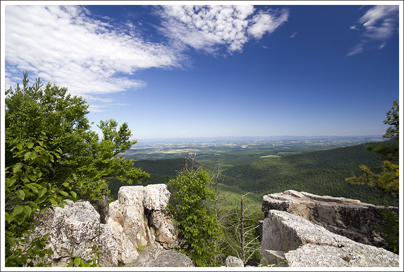
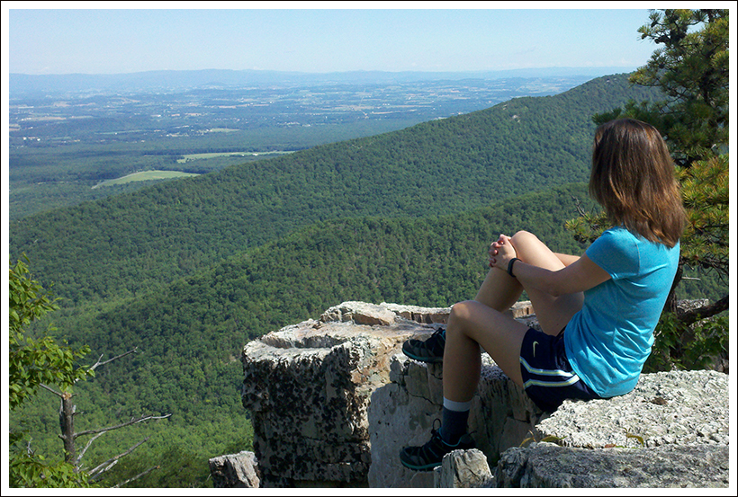
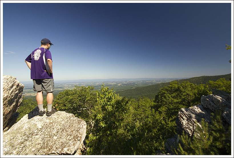
The last push to the fire tower was fairly steep, but once we reached the lookout the vista was open in every direction.  It was also a lot colder and windier.  Without the shelter of trees, the wind was whipping 25-30 mph. We explored the summit for a while – looking over toward the Presidentials, spotting the wind turbines on the ridge next to my parents’ house and guessing the names of lakes we could see from the top.  Cardigan is made of Kinsman Quartz Monzonite, a rock similar to granite.  It’s beautiful and almost shimmers and sparkles in the sun.

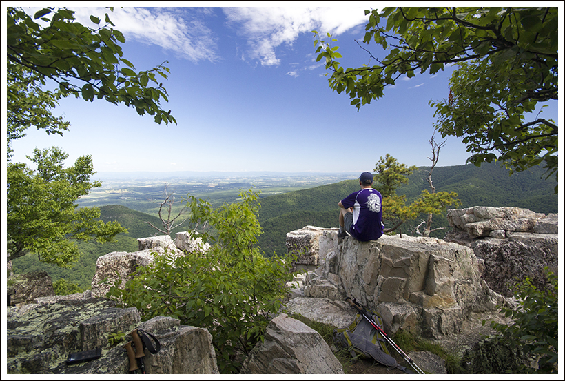
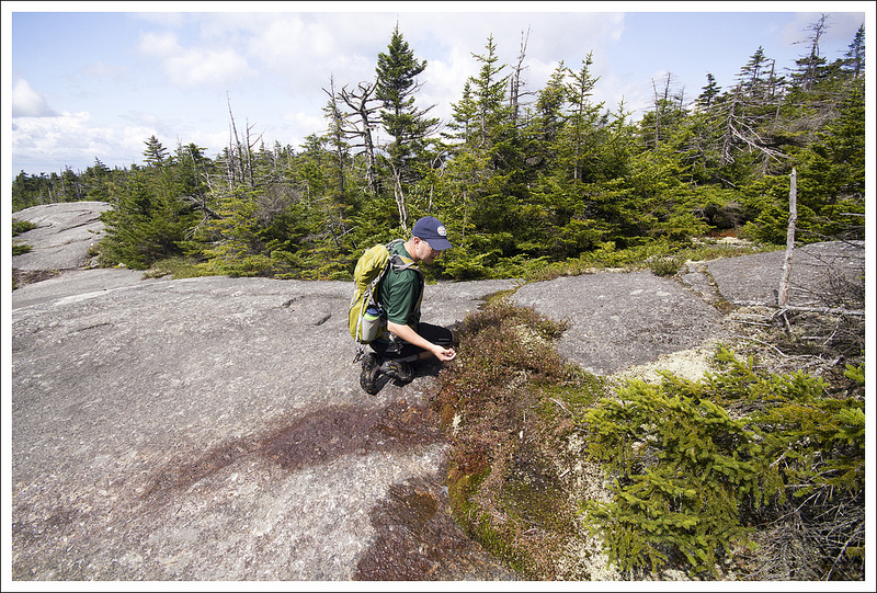
To make the hike a little more diverse, we decided to descend by the South Ridge Trail. This took us by the Fire Lookout Cabin and the South Peak and Rimrock summits.    We enjoyed a couple more beautiful views.  It was fun to look back up at the fire tower from the South Peak and marvel at the terrain we covered. This part of the trail also offered a bounty of wild blueberries.  The berries were perfectly ripe – the ideal combo of sweet and tart.  I know we have wild blueberries in Virginia, but I would swear the ones in New England taste better!

Mt. Cardigan Fire Tower
The Mount Cardigan Fire Tower. Below: Cairns mark the way as the fire tower comes into view,  the steep descent; the rock was steep and slick.

Approaching the Fire Tower Descending Cardigan Slick Rock

We didn’t expect the trail down to be so steep and rocky (especially the section after we crossed the Skyland Trail again), or to get caught in a pop-up rainsquall.  Weather really does change in an instant in New Hampshire! I had my rain jacket in my backpack, but we were so close to the end of the trail that we just picked up the pace and jogged the rest of the way back.   There’s a lack of photos for the portion of the trail that required us to run through the rain, but overall you get the gist of what this trail is all about.

When we got back to the car, the parking lot was jam-packed.  Several cars were circling like vultures to claim the spot we were about to vacate.  Soon, we were on our way, headed in the direction of Canaan, NH.  We decided to grab lunch at a little diner-like place called ‘Dishin’ It Out’.  As it turned out, Canaan was holding it’s Old Home Days weekend when we visited.  Old Home Days are a New England tradition, kind of a mix of a homecoming and a fair.  There were food stands, craft vendors, fresh produce, local maple syrup, softball games and even cow chip bingo.  It was a fun ending to our first hike of the trip!

Fire Tower
The summit is dominated by the fire tower. There are great views and lots of small pools on the summit.

Adam Says…

As Christine mentioned, this was a great introduction to hiking in the White Mountains.  As we were driving along to Mt. Cardigan State Park, moose crossing signs made us excited about the possibility of spotting one of these elusive creatures.  We weren’t lucky enough to spot any moose, but as we got closer and were driving into the wooded park area, we knew we were about to take on a classic New England hike.  You can download a trail map here.

The trail started off with a few stairs and then started a rather gradual uphill climb.  At .4 miles, the trail intersects with the South Ridge Trail, our return route.  We stayed on the West Ridge Trail and continued the climb.  At .9 miles, the trail intersects with the Skyland Trail.  Continuing on the trail begins to open up to more views and as you continue to climb, the trail rises above the treeline.   At this point, you follow carefully-placed cairns until you reach the summit.  We passed a sign that showed the intersection with the Clark Trail,  reaching the summit and fire tower at 1.4 miles where the wind was blowing strong and cold.  Even though the cold air had my nose running, I didn’t feel like getting out my jacket.  The fire tower was locked but one of the sides served as a good protector against the wind.

We shared the summit with a couple of guys that were using a mirror to signal someone down at the lodge where they were staying.  I never could tell if they were returning signals back to them.  We stayed at the summit before making our descent down.  We decided to make a little loop of our hike and descended back to the sign that showed the intersection with the Clark Trail.  We followed the yellow-blazed Clark Trail as we sharply descended the mountain to connect us to the South Ridge Trail, leading us past a locked building.  Passing the building, we started to spot blueberries all around.  At 1.75 miles, the trail intersected with the orange-blazed South Ridge trail.  We took the South Ridge Trail and it was fairly level and winded through a low-brush area until we reached the South Peak.  We continued along and met the summit of Rimrock at 2.1 miles.

Rimrock
From Rimrock, we could see a rainsquall approaching. Below: The fire lookout cabin; Adam picking blueberries; From South Peak you can look back toward the fire tower atop Cardigan.

Fire Lookout Cabin Picking Blueberries South Peak View

At this point, the South Ridge trail crosses the Skyland Trail and then changes its blaze color from orange to white.  This part of the trail was very steep and rocky, reminding us of some of the tough climbing down we did from Grandfather Mountain in North Carolina.  We pressed on down this tough section of trail, wishing we had taken the Skyland Trail back to the West Ridge Trail (which is what we would both recommend to save the strain on your knees).  At 2.9 miles, the South Ridge Trail finally ended and intersected back with the West Ridge Trail. We took a left here and made our way back to our car at 3.3 miles.

The downhill from Mt. Cardigan had Christine worrying about her knee, especially when the rain started.  We had to move quickly for the last .4 miles.  When we got to the parking lot, the lot was now overflowing with cars.  We were so glad that we started the hike early and that we had good views at the top.

Mount Cardigan has been a popular place for hiking since the 1800s.  In 1855, a forest fire destroyed most of the trees at the top of the mountain, which has left it as the bald that you see today.  Because of the ability to see from the summit, a wooden fire tower was built here in 1904, to be soon replaced with a steel tower in 1924.  On a clear day, you can see Mount Washington and other peaks in the White Mountains of New Hampshire, Pleasant Mountain in Maine to the east, and Camel’s Hump in Vermont to the west.  Some people choose to stay at the nearby Cardigan Lodge, operated by the Appalachian Mountain Club, and hike an alternate route to the summit for 5.2 miles roundtrip.

Descent into the Woods
The descent into the woods was steep and rocky. Below: More steep descending.

Steep Cardigan

The panoramic scenery from the top was truly breathtaking.  Based on what we had hiked before in New Hampshire to this point, it was one of the best views we had seen up here.  Of course, we were just getting started for this trip and we ended up having some other hikes take the prize for best views here.  However, you won’t be disappointed in hiking up to Mt. Cardigan on a clear, summer day.

Trail Notes

  • Distance – 3.3 miles
    (Check out the stats from MapMyHike)*
  • Elevation Change – About 1250 ft.
  • Difficulty –  3.  By Virginia standards this is a moderate hike, but by New Hampshire standards it’s an easier hike that still offers great views.
  • Trail Conditions – 3.  Like most New Hampshire trails, this trail is a mix of smooth rock, roots and mud.  Trail builders have done a great job building bridge and planks to traverse muddy areas.
  • Views – 5. Spectacular… if you can see mountains in three different states, you know it’s good!
  • Waterfalls/streams 2.  There are small streams, but really nothing scenic or noteworthy.
  • Wildlife – 2. We saw a red squirrel and a variety of birds.
  • Ease to Navigate – 4. Trails are well marked and free trail maps are available at the trailhead.
  • Solitude – 1.  If you start early, you can avoid crowds, but this is a popular trail.

Download a trail map (PDF)

A friend of mine (and native New Englander), Ben Kimball, sent me some additional resources! Check out his brochure about the ecology of Mt. Cardigan.  The publication also includes an alternate hike route starting from the AMC Lodge. He’s also provided a link to a page with photos and more information about the mountain hosted by the New Hampshire Division of Forests and Lands. Thanks, Ben!

Directions to trailhead: From Route 4, head north on NH-118/Dorchester Road.  In .5 miles, turn right on to Cardigan Mountain Road.  Stay on this road for close to 4 miles until you reach the parking lot area.   The West Ridge Trail marker is on the northern end of the lot.

* MapMyHike is not necessarily accurate, as the GPS signal fades in and out – but it still provides some fun and interesting information.

Murphy-Chambers Farm – Harpers Ferry

This 2.2 mile route is more of a historic stroll than a true hike, but it’s definitely worth doing if you’re in Harpers Ferry and don’t have time for more significant hikes, like Weaverton Cliff, Loudon Heights or Maryland Heights.

Cannons on Murphy Farm
This short hike has a lot of interesting history. Below:  Meeting Jennifer Pharr Davis, Brew Davis and baby Charley; Berries on the trail; The beginning of the route.

ATC Talk Berries Trailhead

Adam Says…

We took a trip to Harpers Ferry, WV primarily to meet Jennifer Pharr-Davis, the current record-holder with the fastest time to hike the Appalachian Trail.  She was giving a talk at the Appalachian Trail Conservancy to promote her new book, Called Again,  and talk about her experiences hiking the Appalachian Trail.  The center holds archives of all the thru-hikers that have made it to this halfway point and while we waited for her talk to begin, we browsed around the center and looked through the photo archives to find some of our friends that had thru-hiked in years past.  We found Jennifer’s talk to be truly inspirational and she took several questions about her experience.

After leaving the center, we decided to take advantage of being in the area and headed to Harpers Ferry National Historic Park.  We drove up to the Visitor Center.  At the gate, there was a line of cars and one car was taking a long time to get through.  While I wasn’t feeling particularly patient either, the car in front of us was shouting for the car ahead to move along.  When this car finally got to the gate, they yelled at the park ranger for being too thorough with the other people’s questions.  They ended up just turning around since they were too mad to enjoy the park.  We felt so bad that the park ranger had to take this abuse.  We paid our $10 entry fee and parked near the Visitor Center.  We talked to the staff there and asked for an idea for a quick hike.  The staff member recommended this hike to us, since she said this had some of the nicest views of the Shenandoah River.  We filled up our water bottles and began our hike.

River View
A view of the river. Below; Stairs climb into the woods at the beginning of the hike; First views; Cannon

Steps View from Trail Cannon

The temperature was scorching this day and we hit the trail in the peak of the afternoon heat.  We both talked about how much we hate the heat of the summer.  Give me fall or spring hiking days any time over humid, hot summer days.

The trail starts from behind the restrooms of the Visitors Center and across the main road.  As soon as you cross the cross the road, the trail bears a sharp left, skirting the tree line.  The trail then goes deeper into the woods and begins a descent including a sharp switchback.  At about .25 miles, the trail crosses a bridge over the small creek and then begins a short climb uphill.  Once you reach the top, the trail opens up to houses on the right and a large field on the left.  We took a sharp left, which hugged the tree line down a path that was cut into the tall grass.  The shade of the trees gave us a little protection from the sun beating down, but it wasn’t quite enough.  At .5 miles, the trail approaches the back of the Murphy-Chambers House.  We decided to continue on and see the house on the return trip.  We continued along the trail and at .9 miles, we reached the John Brown Fort foundation.  John Brown was such an interesting character in American history and I remember writing a paper in college about his activist behavior.   A short distance from the foundation, the trail dips into the woods for the view of the Shenandoah River.  You get a nice view of the river and we weren’t surprised to see large rafts floating down the river.  We continued from this point to take a right at the next junction (rather than continuing on to the earthworks) to head back to the Murphy-Chambers House.  The trail follows a rather straight path and there wasn’t any shade to be found from the sun at this point.  At 1.2 miles, we reached an area of cannons and learned about how Confederate General A.P. Hill maneuvered his troops to a fortified position on this hill.

From here we continued on the trail which led to a gate keeping an unpaved road from going any further.  There is a parking lot here and a path to the right leads to the Murphy-Chambers House.  The Union took over this farm in 1862, ousting the Chambers Family.  While he tried to claim restitution for his property, there is no evidence that he was ever paid.  In 1869, Alexander Murphy re-established the farm.

We continued along the trail on the unpaved road until we reached the junction again that led back into the woods at 1.5 miles.  We followed the trail back to the Visitor Center and our car.  While the day was incredibly hot, it was nice to get out and stretch our legs and learn a little about the history that shaped this area.

Christine Says…

If the weather had been cooler or if we’d had more time, we would have opted to take one of the longer hike options in the area.  But after spending Saturday visiting Charlottesville-area wineries (Horton and Barboursville), touring James Madison’s Montpelier and enjoying a huge dinner at the Barbeque Exchange, we got a very late start on Sunday morning.  So late, in fact, that we were worried about making it to Jennifer Pharr Davis’ talk in time.  The original plan had been to have a leisurely lunch in downtown Harpers Ferry and then make our way to the ATC.  As it turned out, we ended up wolfing down Subway in Charles Town and making it to the talk just in time.

Murphy Farm
The Murphy-Chambers Farm; Adam checks out route options, John Brown historical site; Rafters

Checking the Map John Brown Historical Site Rafters

Jennifer’s talk was everything I hoped it would be and more!  I will never be a tenth of the athlete that she is, but she inspires me to get out there and challenge myself.  She loves the Appalachian Trail, and despite all the amazing places she has hiked, the AT is still her favorite.  Some people might think that setting a speed record on the trail would preclude appreciating or enjoying the beauty and the experience of nature.

But after hearing her speak and reading Called Again, I believe she found new levels of beauty, love, and personal fulfillment.  People hike the trail for a variety of reasons – to see scenery and wildlife, to engage in self-discovery, to challenge oneself physically or to form/deepen personal relationships.  Jennifer may have flown across the trail in a mere 46 days, but she still had all the experiences you would expect a person to have along the way.   I really enjoyed Jennifer’s first book Becoming Odyssa, but Called Again was even more rewarding.  I also added Brew Davis’ book (Jennifer’s husband) to my reading queue.  I expect his side of the story to be equally fascinating!

Fawn
We spotted a cute fawn. Below:  The return arm of the loop; Adam at the ATC.

Path ATC Adam

OK… now on to the hike!  Adam has already done such a thorough job describing the route and points of interest, that I really don’t have much to add.  I will echo his sentiments about the heat.  I felt like I was going to melt into a pool of sweat on the trail.  The day we were there was the beginning of one of the only really hot weeks we’ve had this summer. It was probably in the low nineties, but it was humid, windless and sunny, so the heat index was 101.  I really don’t like to hike when it’s above the mid 80s, so this wasn’t a particularly fun hiking day.  Even if there had been more time to explore the area, I don’t think I would have wanted to do a longer hike in this heat.

Nevertheless, I enjoyed the views of the river and the historical attractions.  If it had been cooler, I would have taken more time to read informational placards.  My favorite part of the hike was spotting a fawn grazing in the field.  From a distance, I saw a brown hump in the grass.  I asked Adam, ‘Is that an animal of some kind?’.  He thought it was a rock and headed over to read about the cannon on display.  I tiptoed along with my camera and found that the ‘rock’ was actually an adorable spotted fawn.  We made eye contact for a brief moment before he flashed his white tail and bounded off into the trees.

We made our way quickly back to the car where I chugged more water and blasted the air conditioning.  The outdoor temp thermometer on our car said 107.  I know that was mostly from leaving the car sitting in the sun… but still!  This short hike in the heat added even more to the anticipation about our upcoming ten day trip north!  Our next five posts are going to be out-of-staters!  We’ll be taking you to the rugged, exciting, spectacular high peaks of New Hampshire!

Trail Notes

  • Distance2.2 miles
  • Elevation Change – negligble
  • Difficulty –  1.  The trail was not very difficult and only had a little bit of elevation change on the hike.
  • Trail Conditions – 4.  The trail is well-established and didn’t have very difficult footing.  Most of the trail is on grass or gravel.
  • Views – 1.5.  The views of the Shenandoah River were somewhat obstructed with trees around. 
  • Streams/Waterfalls – 2.  You do get one heightened view of the Shenandoah River from this point.
  • Wildlife – 2.  I believe we were fairly lucky to see a fawn on the trail.  I would expect to see field birds here for any bird-watchers.
  • Ease to Navigate – 4.  The trails mostly inter-connect here, so you shouldn’t get lost.
  • Solitude – 4.  My guess is that most people that visit the Visitor Center do not hike up to this area, but you may see some people at the Murphy-Chambers House. 

Directions to trailhead:  From Charles Town, WV head north for about 4.5 miles.  Turn right on Shoreline Drive (about .8 miles past Millville Road).  The entrance fee station is just ahead and the large parking area is to the right.  Walk up to the Visitor Center and the trail is across the road behind the bathrooms.

Calvary Rocks & Chimney Rock

If you’re looking for a short, easy hike in the vicinity of the Riprap trail (southern district – Shenandoah National Park), the 3.4 mile walk to Calvary Rocks and Chimney Rock is a great option.  It follows the same route as the 10-mile Riprap circuit, but turns around right after two excellent viewpoints.

NPS Riprap Area Trail Map

View from Chimney Rock
The view from the second viewpoint along this short, pleasant hike. Below: Adam at the trailhead; Hiking the AT; along the AT

Trailhead Walking the AT

Christine Says…

After our long hiking trip to North Caroline and Tennessee, I came home with a really sore knee.  Every step I took, it felt like someone was sticking an ice pick into the soft tissue under my kneecap.  Even after a week’s rest, it didn’t feel better, so I reluctantly made an appointment with an orthopedist.  He couldn’t find anything obviously wrong, so he diagnosed it as a bit of IT-band syndrome, a bit of inflamed cartilage and maybe the beginnings of arthritis.  I was given orders to cross-train… which is essentially code-speak for ‘do something other than hiking‘.  Bah!   So, I spent most of June and July in the gym, doing cardio equipment and weights.  I only managed to hit the trail a few times – all short and easy hikes. This walk to Calvary Rocks and Chimney Rock was one of those hikes.

It was a beautiful, sunny, crisp day for midsummer.  We set out in the morning and had the trail almost completely to ourselves.  The hike started off in the same parking lot as the longer Riprap loop hike.  The hike follows the Appalachian Trail uphill for almost a half mile before intersecting with the Riprap trail.

At the junction, turn left onto the Riprap trail.  The first viewpoint, Calvary Rocks comes shortly after passing a small talus slope.  There are two small outcroppings of rocks at this viewpoint.  It’s pretty, but in my opinion, the second view from Chimney Rock is the nicer of the two.

Taking in the view.
Taking in the view. Below: Flowers blooming along the trail; A bug finds shelter; Ripening blueberries; Indian pipes.

Wildflowers Wildflowers
Blueberries Indian Pipes

The second view comes several tenths of a mile past Calvary Rocks.  The view is great and this outcropping is a bit more expansive.  There are lots of places to scramble around.  There were also a ton of blueberries growing around Chimney Rock.  Most of them weren’t ripe, but I found a few that were dark purplish-blue and sweet-tart!

We lingered on the rocks for a while before heading back the way we came.  It was great to be out on the trail after so many days of doing indoor workouts, and (thankfully) my knee held up pretty well!

Adam Says…

This truly hasn’t been a typical summer in Virginia.  I remember brutal, hot, muggy summers in which we never could feel we could escape the heat.  Luckily, this summer has been much cooler.  The bugs have also not been as bad this year, which has made hiking much more pleasant.

This was a test for Christine’s knee to see if she could take another hike after just a little rest.  The amount of hiking we did in the Smokies demanded for some time off, but I was glad her knee was cooperative on this hike.

Calvary Rocks
Calvary Rocks are geologically different looking than most of Shenandoah’s rocks. Below: Views!

Views Views Views

We started from the parking lot and began our hike uphill on the white-blazed Appalachian Trail.  In about .4 miles, you reach the junction with the Riprap Trail.  Take a left here and the trail goes down steeply before ascending.  Around 1.2 miles, you will reach your first viewpoint of Calvary Rocks.  There are some very nice views here, but not a lot of room to spread out if there are others on the trail.  Continue from here along the trail and around 1.7 miles, you will reach Chimney Rock.  Chimney Rock has great views and a little more room to enjoy the views with others or stop to eat a snack.

Along the trail, Christine was complimenting me on my ability to be able to find indian pipes.  She is definitely the wildflower expert between the two of us, but for some reason I tend to spot indian pipes before she does.  We found a few nice specimens along the trail.

Buck
Handsome buck near the trailhead.

We lingered for a short while to enjoy the views on such a nice summer day.  We made our way back the same way on the return trip.  If you would like some nice views with little effort, this is hike in the south district of Shenandoah National Park that shouldn’t be missed.

Trail Notes

  • Distance – 3.4 miles
    (Check out the stats from Map My Hike)*
  • Elevation Change – around 680 feet
  • Difficulty – 2. This hike is short and easy without much climbing or descending.
  • Trail Conditions – 4. The trail was in great shape.
  • Views4. The views are nice, but they aren’t panoramic,
  • Waterfalls/streams – 0. None. If you want to see streams, you’ll have to do the full Riprap loop.
  • Wildlife – 2. We saw a nice looking buck near the trailhead.  Bears are known to frequent this area.
  • Ease to Navigate – 3. The trail is well-marked and there is just one trail junction.
  • Solitude – 3. We didn’t see many people at all on this hike!

Directions to trailhead:
From Skyline Drive, park on the western side at mile marker 90.  There is a parking lot specifically for Riprap hikers.

* MapMyHike is not necessarily accurate, as the GPS signal fades in and out – but it still provides some fun and interesting information.