This is a great alternative to the ‘classic’ ascent of Old Rag. You still get the same stunning summit, but this 5.4 mile route lets you bypass all the road walking, lessens your vertical gain, and skips the famous rock scramble (which can be a good or bad thing depending on how you feel about rock scrambles!)
View the Full Album of Photos From This Hike


Adam Says…
Old Rag is one of those classic Virginia hikes that most avid hikers in the state want to do at some point. The views are truly spectacular, but the most popular route up Old Rag includes a technical rock scramble with exposed ledges and big drops. Some people might have a fear of heights or not be fit enough to tackle the scramble. The route via Berry Hollow is perfect for people wanting a ‘low key’ route to the peak.
We were on our way to hike White Oak Canyon, but the parking lot was completely full. Not wanting to give up for the day, we consulted our maps and noticed we were right next to Berry Hollow and the alternate route up Old Rag.
We arrived at the small parking lot at Berry Hollow and also found a very full lot. However, after waiting just a few minutes, some hikers came down the trail and said about 3-4 cars would be leaving in the next ten minutes as they were returning from an overnight/sunrise hike. So, we waited and sure enough, several spaces cleared up. I would recommend arriving at the lot early in the morning, because there is only space available for about 12 vehicles.
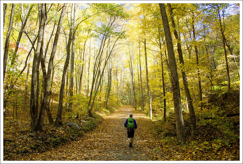
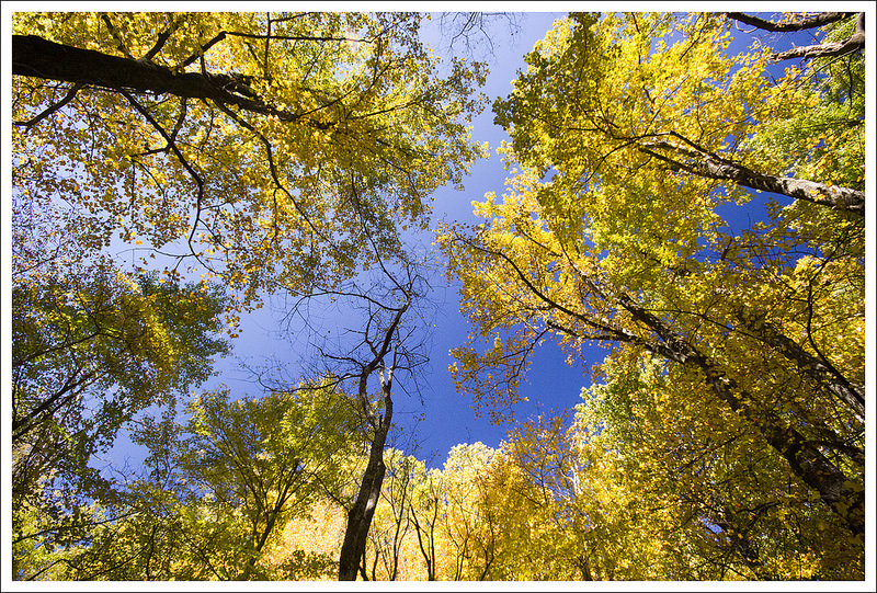
You begin the hike by making your way past a closed gate. You can see the path marked on the kiosk to the right of the trail. This route starts on the wide Berry Hollow fire road, which goes along the Berry Hollow stream for a while. Hiking the trail during a peak fall day, we were surrounded by brilliant yellows from fallen leaves on the trail and up above. At .8 miles, you reach a junction with the Saddle Trail. Take a right on to the Saddle Trail, which you will take all the way to the summit.
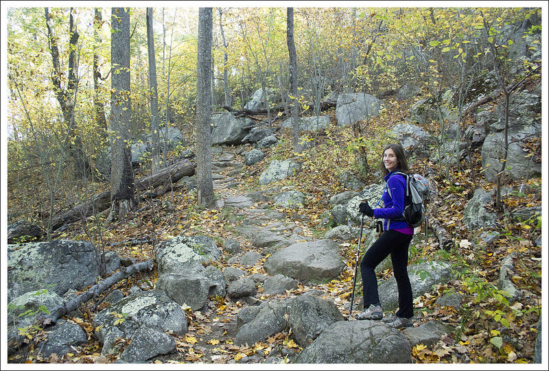


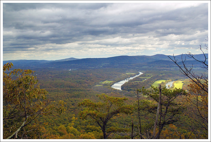
The Saddle Trail is more narrow and rocky, but is mostly a moderate climb. The steepest part of this trail comes between 1.2 and 1.5 miles as you gain about 300 feet of elevation in .3 miles. At 1.4 miles, you will pass by the Old Rag shelter which is only available for day use. At 2.15 miles, the trail gets another steep push to the summit. Continuing up the trail, you will also pass the Byrds Nest Shelter at 2.25 miles, another day use shelter. The trail does start to open up to some views along the way as you’ll pass a couple of rock outcroppings that give you nice views or a good excuse to stop if you need a breather.
You arrive at the base of the summit which is marked by a sign. A short path leads up to the rocky summit. At this point, you can decide how adventurous you want to be at the summit. There are lots of nice ledges to enjoy the views, but some will want to scramble up the boulders to try to get even higher vantage points. Be very careful at this summit, especially if you have kids. People get injured often on this trail, most often at the rock scramble or at the summit.
The wind was incredibly strong on this day at the summit. It is usually quite windy at the summit, but with the colder temperatures, it was freezing at the top. We ate some snacks at the top, trying to shelter us from the wind, but decided quickly to get away from the exposed ledges to try and stay a little warmer.
We headed back the way we came. When we arrived back at our car, the lot was still at capacity, so we did luck out with a spot. After our hike, we went to one of our favorite places to eat, The Barbeque Exchange, in Gordonsville, VA and then hit Horton Vineyard for wine sampling on our way back home.
We were so pleased with this alternate route up Old Rag. I think we will probably use this as our go-to route for future hikes up the mountain.
Christine Says…
I make no secret of the fact that I am not a huge fan of the Old Rag Ridge Trail. Scrambling is not my favorite, but my primary issue is simple trail overuse. I think the park lets too many people hike the trail each day and that the mountain is becoming damaged beyond repair. We’ve hiked Old Rag on days that people are queued up all across the ridge, waiting in line for the people ahead of them to tackle obstacles. I wait in line in daily life enough that I’m simply not willing to wait in line on a mountain trail. It feels wrong! I also don’t prefer the significant amount of road walking necessary to complete the route via Weakley Hollow. In the end, more than half the trail is road walking. That said, I did really enjoy this ascent via Berry Hollow.
It was our anniversary weekend, peak fall color, and a perfect bluebird day to boot. We were sort of nuts to try hiking any of the park’s most popular trails, but somehow we were lucky enough to score a parking spot.


The walk up Berry Hollow fire road was gorgeous. The sun filtering through the fall leaves made a canopy of warm golden light. The road was carpeted with leaves of every color. We really didn’t see many people at all until we reached the junction of the fire road and the Saddle Trail.
The Saddle Trail is a moderate ascent. There are rock steps and interesting boulder jumbles to admire along the way. Through the trees we could see the rocky summit looming ahead. As we climbed the views became more impressive. After passing the second shelter (Byrds Nest), the trail passes out of tall hardwood forest into stand of stunted, windblown trees and tangled rhododendron.


There are a couple nice views from the trail before you reach the actual summit. We took time to enjoy each of them. At the summit, there was a large crowd already congregating. Most people posed for photos and then found places behind the boulders to shelter from the wind. We stayed and enjoyed the summit until it became too crowded.
The way down was quick and easy! We even did our traditional ‘Old Rag Jog’ – it’s basically a slow run to make the fire road terrain pass quicker. On our way out, we stopped by Graves Mountain to get apples, pumpkin, and cider. Then we headed for a big barbecue feast and a wine tasting. It was a perfect fall day and a great way to celebrate our anniversary.
Trail Notes
- Distance – 5.4 miles
(Check out the stats from Map My Hike)* - Elevation Change – 1725 ft.
- Difficulty – 3. This is a solid, moderate hike.
- Trail Conditions – 4. The trail was in great shape in most places. There were a few muddy, mucky places between Byrds Nest and the Old Rag Shelter.
- Views – 5. Gorgeous views at the top and several nice views along the way.
- Streams/Waterfalls – 1. There is one small stream along the fire road.
- Wildlife – 2. We didn’t see anything but squirrels, but there is apparently a nuisance bear near the Old Rag shelter.
- Ease to Navigate – 4. There is just one well-marked junction.
- Solitude –0. It’s Old Rag… expect to see many, many people.
Download a Trail Map (PDF)
Directions to trailhead: From Madison, VA on Route 29, take US-29 Business Route into Madison, VA. Turn on to VA-231 north. In 5.4 miles, take a slight left on VA-670. Follow this for 3.6 miles and take a slight right on to state route 643/Weakley Hollow Road. Follow this road for about 5 miles, which becomes a gravel, fire road and ends at the parking lot for the trailhead.
* MapMyHike is not necessarily accurate, as the GPS signal fades in and out – but it still provides some fun and interesting information.