Blackbird Knob – Dolly Sods (WV)

This 5.8 mile out-and-back hike along the Blackbird Knob trail gives you a sampling of many of the beauties offered by the Dolly Sods Wilderness area. While you don’t get any high-up, panoramic vistas, you still get amazing views across the high plateau.

Adam and Wookie in Dolly Sods
Dolly Sods is spectacular in the Fall. Below: Trailhead along the forest road; Off to a chilly start! The morning was breezy and in the 30s; Dolly Sods is famous for turning crimson in the fall.

Forest Road Off to a Chilly Start Berry Bushes Turn Crimson

Adam Says…

Fall is here!  At least it has arrived in Dolly Sods.  For those that haven’t been to visit out this wilderness area on the eastern side of West Virginia, you will be impressed by the terrain.  I have read many times that the terrain and climate up here is more similar to Canada than the surrounding areas of West Virginia and Virginia.  You will quickly notice that the vegetation is just different here – you’ll see spruce and conifers in one direction and blueberry bushes and boggy areas in another.

After hyper-extending my knee on our last backpacking trip, I was thinking another trip the next weekend would be a little too much of a re-injury risk.  But, we wanted to do something fun since it was Christine’s birthday, so I suggested that we spend the weekend in Canaan Valley to enjoy some of the early fall color.  The last weekend of September is usually the Leaf Peepers Festival in Canaan Valley, but we were hoping for some fall color the week before and we weren’t disappointed.

Wilderness Wookie Enjoys Dolly Sods
Wookie rests on a warm rock in the sun. Below: Christine checks out a trail marker.  There are very few signs and no blazes in Dolly Sods; Fall color is starting to pop; Walking past a colorful maple.

Trail Sign Fall is Starting Walking Past the Maples

I feel it is necessary to put out a few warnings about Dolly Sods.  First, the trails are not well-marked.  They typically will have some trails marked at intersections, but there are no blazes on the trails and if you wander off on something that looks like a trail, you could become lost.  Second, the road to get to and through Dolly Sods is very rough.  You won’t see many Toyota Prius-like cars on this road.  We approached it from Canaan Valley and there are some scary roads to drive up.  You are on a road barely able to fit two cars with a large drop-off on the side.  We were almost hit by some locals barreling down a blind curve on the road and they only missed hitting us by a couple of inches.  The road through Dolly Sods is also extremely rough and filled with potholes.  We’ve gotten a flat tire up here before and hope to never experience that again.  You’ll need to drive very slowly and steer away from any potholes or sharp rocks sticking up.  Four-wheel drive is not completely necessary, but it may give you ease of mind.  Third, good maps are hard to find.  As I mentioned on our Rohrbaugh Plains post, probably the best maps are available online.  If you are looking for printed maps, we’ve bought quadrant maps of the Dolly Sods area from the nearby Seneca Rocks Discovery Center, but I’ve found some flaws with these marking trails properly (the quad for Blackbird Knob showed the knob on the wrong side of the trail).  The online maps area also from 2006 and the quads are mostly from 1995.

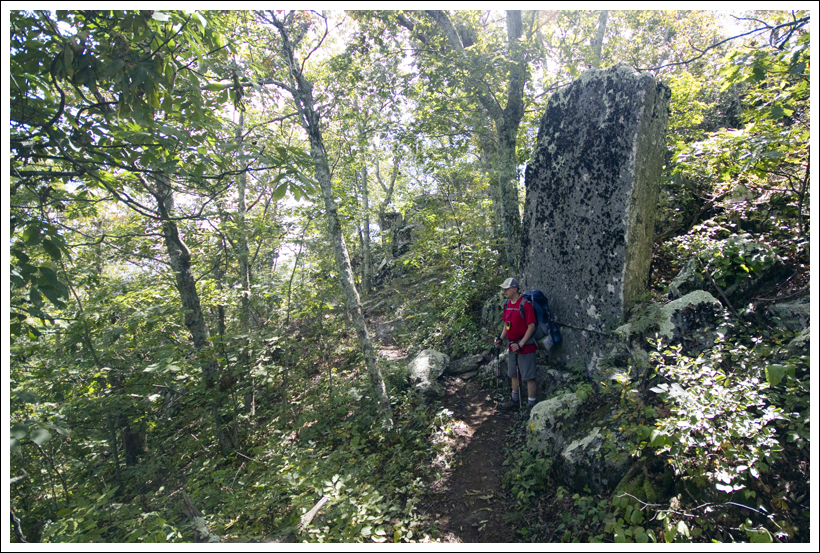
For the hike to Blackbird Knob, we parked on the eastern side of the road just north of the Red Creek Campground area.  You should see the large trailhead sign on the western side of the road just past the campground area.  You quickly cross a boardwalk over a boggy area and then you will pass a large open area of pine forest to the right.  In .3 miles, you will come to a grey sign that shows the trail goes to the left deeper into the woods.  You may not see a trail to the left, but follow the sign and you will begin to see cairns that will lead you back to where the trail is more apparent.  At .5 miles, the trail opens up to a larger field with nice views around you.  The trail begins to descend at this point, but you will still see some views as you are walking through an open field.  At mile 1.1, you reach Alder Run, which requires a small rock-hop to get across.  You will then go slightly uphill through the forest again, but it will soon open up to more views.  The trail then goes back into the woods and you will arrive at Red Creek at 1.6 miles.  You will need to do more substantial rock-hopping to get across, but we didn’t have any trouble.  The trail goes steeply uphill at this point.  At 1.8 miles, the trail again opens up to spectacular views.  You will shortly come across a junction with the Upper Red Creek Trail at 1.9 miles.  Stay straight on the trail and you’ll duck back into forest.  At 2.1 miles, you’ll reach another junction with the Red Creek Trail, which leads back to the campground.  Stay straight again and it will finally open up to spectacular views.  You are then making your way along the circumference of Blackbird Knob.  Gorgeous fields with ridge views to the left give you many options to take in the sites.  There are boulders on the hillside that seem to be placed by nature as auditorium seats to enjoy this area of wilderness.  We continued along the trail until about 2.9 miles, when the trail was going to continue back into the woods.  We turned back and returned the way we came.

Berry Bushes
Color everywhere! Below: Fall foliage scenery along the Blackbird Knob Trail. Below: Enjoying the fall color.

Dolly Sods is Spectacular in the Fall Fall Color in Dolly Sods Maple

Time for a few confessions.  We had packed our bags fairly quickly to head out for our hike.  I forgot to pack the lunch that we were going to eat on the hike.  All that I brought with us was a small bag of nut-heavy trail mix.  Christine has a mild nut allergy, so we were a little concerned about food.  I remembered that I left some Combos in the car, so we were saved with that.  But, I need to learn to be a little better prepared when going into this area.  As I mentioned before, maps of Dolly Sods are hard to find and trails are not marked very well.  We were surprised how many people just came out here and were hiking without maps.  We ran into a few guys that were unsure of where they were going.  I showed them where we were on our map and they said they would just go on ahead and hope they can catch a trail that will eventually loop them back to where they were.  Not the smartest strategy.

We really enjoyed our trip to Dolly Sods to explore this area.  Since we hadn’t received much fall color yet in Virginia, it felt like we had a private advanced screening of the color that we’ll experience here in a few weeks.

Christine Says…

Dolly Sods is somewhat of a phoenix that has risen from the ashes.  Its rugged beauty is actually a mask that belies years of abuse and damage.  Until 1930, Dolly Sods was heavily logged.  Entire mountainsides were stripped bare of their pristine, old-growth forest.  The largest tree ever harvested in West Virginia came from this area – a magnificent white oak – about 1000 years old and nearly as big as a Giant Sequoia.  Once the hillsides were barren, woodchips, fallen pine needles and small trees dried in the sun and became perfect fodder for catastrophic fires.  Flames consumed more than 24,000 acres, scorching the earth down to bare rock.  After the logging industry closed up, the government purchased the land.  In the 1940s, Dolly Sods was used as a training range for the military.  As recently as 2006, a significant amount of unexploded ordnance was still being found along trails.

Red Creek
Red Creek gets its red color from tannins.  Below: Adam and Wookie cross; Fall color and a rocky stream bed; Trail marker in Dolly Sods.

Stream Crossing Fall Along the Creek Trail Sign

Despite all the damage the land has endured, it is still one of the most breathtaking places in the entire mid-Atlantic.  I don’t think it’s hyperbole to say that there is nothing else like it.  We were lucky enough to visit this fall on one of those perfect, technicolor, early fall days.  The sunshine was sparkling, the sky was crystal clear and deep blue.  Already, maples were turning to flame-color and entire hillsides of fern were glowing and golden.  While Dolly Sods is rugged as a whole, the Blackbird Knob Trail is gentle and without much change in elevation.  Because it was an easy hike, we decided to bring Wookie along.  He was so excited to finally be on a hike!

We started out along a clear path through the woods, but at the first trail sign, we became a little confused.  The obvious, worn path led in the opposite direction of the directional marker on the trail sign.  We sat and pondered for a moment.  We consulted a map.  We didn’t see any sign at all of a trail leading in the arrow’s direction, so we assumed a prankster had turned the sign.  We took the trail a short way uphill before it dead-ended in a thicket of laurels.  We backtracked and followed the arrow’s direction.  For a short while, we were just walking through the woods, but eventually we spotted the cairn and then finally we were back on worn trail.  This is very typical of Dolly Sods!

The first open view came shortly after our brief detour.  From a pile of rocks, we could see all across the high plateau.  Distant hillsides were already covered with red foliage.  The open meadows were covered with crimson berry bushes and tall, tawny grass.  We all stopped to enjoy the perfect fall day –  I snapped photos and Wookie stretched out on a warm rock.  After a brief stop, we continued along.  A few minutes later, we passed a pair of backpackers.  Then we passed three more.  Then we passed five more.  Passing backpackers became pretty much the ‘norm’ for the rest of the hike.  All in all, I’m sure we saw thirty or more people out for the weekend. Typically,  I think of Dolly Sods as being rather remote and isolated.  On this particular weekend, it was not the case.  People were everywhere!

Ferns and Fall Color
It was a technicolor day in Dolly Sods.  Below: Adam hikes across the open terrain; Fall color all along the hillside; Christine enjoys the fall color.

Hiking Along Fall Color in Dolly Sods Christine Enjoying the View

Throughout the hike, the trail passed in and out of trees and open spaces.  We crossed Alder Creek and Red Creek.  Both were running, but on the low side.  I’ve heard that streams are often uncrossable in Dolly Sods in the spring.  It’s hard to imagine that when you see them running so meagerly in the early fall.  Red Creek was especially lovely.  Tannins give the water a rich, reddish color.  I suppose the name ‘Red Creek’ is very well-suited for this body of water!

When we reached the end-point of the hike, we stopped for a snack.  As Adam mentioned, he forgot our lunches.  So, he ate peanuts and cashews, while I picked all of the remaining M&Ms out of the trail mix.  It was enough to tide me over for the walk back to the car.  Honestly, it was such an easy hike that it really didn’t require that much energy.  It also left me nice and hungry for an early dinner at Hellbender Burritos.  For a tiny town, Davis, WV has two very good restaurants (the other is Sirianni’s Pizza Cafe).  At Hellbender, I got my favorite Gendarme burrito.  It’s basically a steak and cheese in a bowl – medium rare chunks of steak, smothered with grilled onions and peppers and then doused with queso.  Yum! And even better (or worse… depends on how I look at it), I discovered Harpoon Pumpkin Cider.  I’m a very picky beer person, but I really like most hard cider, and this seasonal pumpkin cider might be the best thing I’ve ever had to drink!  Sadly, it’s very, very hard to find in our area.  Even the local beverage shop can’t special order it and it’s nowhere to be found in stores.

Wookie Says...Wookie Says…

Sometimes the tail says it all.  What I mean by that is that on this hike for most of the way, my tail stayed nice and curled.  When I get tired, it tends to start drooping like a flag slowly being brought down the pole.  But I really enjoyed myself in Dolly Sods Wilderness.  This was my first trip out there.  Christine and Adam often call me, “Wilderness Wookie”, but this was the first time I have been in true designated wilderness area.

Wookie Crossing Red Creek
Wookie crosses the stream. Below: Adam and Wookie hike on the return leg of the out-and-back; Adam enjoys fall color; Don’t miss a visit to Bear Rocks when you’re in Dolly Sods.

Wookie and Adam Hike Hillside of Color in Dolly Sods Don't Miss a Visit to Bear Rock

My highlights of the trip were when first reached the open field around .5 miles.  I spread out on a nice rock, sniffed the brisk, fall air and enjoyed the views.  I also really enjoyed eating a few cashews from the base of Blackbird Knob.  Christine poured a little rock in a natural bowl in the rock and Adam gave me some nuts to help me re-energize for the return trip.

My lowlights of the trip were crossing Red Creek and the initial boardwalk.  The boardwalk made me a little uncomfortable since there were spaces where my paws could have slipped through.  Crossing Red Creek was a little more troublesome.  I really don’t like getting my feet wet.  But, I took a wrong step and got my front paws wet.  I jumped back away from the water and then made a successful second pass.  My tail immediately went down to let Adam and Christine know that I didn’t like getting wet.  I don’t mind mud as much and my feet did get quite muddy along the trail.  But by the time that we got back to the car, most of the mud had come off.

Going almost six miles is a little taxing for a pug.  For some reason, I don’t see a lot of other hiking pugs out there.  When we got to the car, I immediately fell asleep and was snoring loudly by the time that we got moving.  Of course, when we got back home I had to strut my stuff and tell my brothers, Yoda and Mojo, that I went on a great hike.  I’m glad it’s finally getting a little cooler again so I can get back on the trails.  Wilderness Wookie is ready to do some more fall hiking!

Trail Notes

  • Distance – 5.8 miles.
    (Check out the stats from MapMyHike)*
  • Elevation Change –  440 feet
  • Difficulty – 1.5. The trail is not that steep at all, so most people should be able to handle it.
  • Trail Conditions – 3.  The trail was in decent condition and was not overly rocky or muddy today.  I do think mud could be a problem after larger rainfalls though. 
  • Views3.  While you don’t get views from a big overlook, the scenery along the way is quite gorgeous.  Open fields and views of mountain ridges in the distance give you a lot to see.
  • Waterfalls/streams – 4. Red Creek gives you a reliable water source and picturesque stream views.  There are plenty of backcountry campsites near the stream if you are planning an overnight backpack trip.
  • Wildlife – 3. While we didn’t see any large wildlife on this trip, the area has plenty of wildlife.
  • Ease to Navigate –2.5. As we’ve mentioned, trails are not blazed and only some junctions are marked with signage. 
  • Solitude –2.  We saw over 30 people on the trail.  Most of these were backpacking groups.  If you go on a nice weekend from Spring-Fall, expect to see others.

Directions to trailhead: From Seneca Rocks, go North on WV 28 for 12 miles.  Take a left on Jordan Run Road.  Go one mile up Jordan Run Road and take a left on to Forest Road 19.  In 6 miles, Forest Road 19 comes to a T on to Forest Road 75.  Take a right, heading north on the gravel Forest Road 75.  Drive for five miles until you pass the Red Creek Campground parking on the left.  Park on the opposite side of the road where the grey trailhead marker is located.

* MapMyHike is not necessarily accurate, as the GPS signal fades in and out – but it still provides some fun and interesting information.

Three Ridges Wilderness

This 13.2 mile circuit can be done as a day-hike, but we recommend extending the beauty and wildness into an overnight backpacking loop. Take your time, and you’ll be treated to panoramic views, lovely mountain streams, demanding climbs and peaceful campsites.

View the full photo album from this backpacking trip on Flickr.

Christine Takes in a View of the Priest from Three Ridges Mountain
Christine takes in a a view of The Priest from Three Ridges mountain. Below: Welcome to the Three Ridges Wilderness;  Over half of the circuit follows the Appalachian Trail; Nothing beats a campfire in the evening.

Welcome to Three Ridges Wilderness Adam Hikes the Appalachian Trail Great Campfire

We had long been planning a three-day backpacking trip across Mt. Rogers, but as the day of the trip drew closer, we started seeing the term ‘Appalachian soaker’ thrown around in weather forecasts.  We’re fine with passing showers and fleeting thunderstorms, but we didn’t want to get pinned down on Mt. Rogers on a wet and stormy night.

Fortunately, the weather in central Virginia was far more favorable, so we ditched our Mt. Rogers plan, and decided to hit another backpacking circuit on our list – Three Ridges.   This route, which makes use of the Appalachian Trail and the Mau-Har Trail, is known as one of Virginia’s most rugged hikes.  Everything we read about the circuit in advance of our trip emphasized the hike’s strenuous nature. With roughly 6,800 feet of elevation change, you’re almost never walking on flat trail.  It’s a constant onslaught of heart-pounding climbs and knee-grinding descents. But along with the challenging terrain, you get spectacular views, beautiful streams and lovely campsites.

We started out early Saturday morning.  The first stop was fuel… for ourselves.  We had a huge breakfast at The Chuckwagon in Harrisonburg.  If you have a chance, stop by and indulge in one of their homemade 4-inch biscuits  (Adam’s favorite is ‘The Round-Up’) or a stack of their amazingly fluffy pancakes.  (Sadly… Chuckwagon closed in January 2013) With full stomachs, we made our way to Reed’s Gap at mile marker 13.7 on the Blue Ridge Parkway.

When we got to the parking area, the lot was already jam-packed, mostly with heavy-duty construction vehicles left idle for the weekend.  Just as we were about to give up and find a parking spot further down the parkway, one car pulled out and left an opening for us!

Some of the Meadow Mountain Climb was Rocky
Adam makes the initial climb up Meadow Mountain. The climbing was occasionally rocky, but never terribly steep.

We started the Map My Hike app on Christine’s phone, hoisted our packs, and headed south along the Appalachian Trail.  From the parking area, the trail hugs the edge of a meadow, which was full of blooming yellow ragweed and purple thistle.  It was such perfect weather for backpacking – sunny skies, low humidity and a crisp breeze.  The trail almost immediately began to climb uphill over Meadow Mountain.   The climbing was steady, but never difficult, for about .8 of a mile.

At the top of the ridge, there was a small dry campsite with obstructed views.  Department of the Interior boundary markers were all along the ridge.  We spotted at least three or four right next to the trail.  After walking briefly along level ridge, the trail descended to Maupin Field Shelter.  The shelter site had tons of space for tents (many of the tent sites were flat, soft and grassy), a typical AT three-sided hut, a metal bear-hang post and a picnic table.  The area also had an informational kiosk with trail notes and wilderness-usage policies.  There was also a child’s orthodontic retainer tucked into a Ziploc and pinned to the board.  We’re guessing there is now one retainer-less Boy Scout and a less than happy mother!

Christine Climbing Bee Mountain
Christine climbs the stone steps up Bee Mountain.

After Maupin Field Shelter we began climbing again, over Bee Mountain.  The climbing was slightly more strenuous, but definitely manageable.  In several places, rock steps were set into the trail to make the climbing easier.  Along the way, we started playing ‘Categories’.  It’s pretty basic – each player designates a category, then players take turns naming items that fit within that category.  For example, categories might include Movies Based on Comic Books or Items You Need on a Backpacking Trip. It’s pretty mindless, but it kills time.  Whoever successfully names the last item for the given category wins the round. The best category of the day was Complaints Uttered When Hills Are Steep. We won’t share the specifics of our trail talk here, but it was pretty funny to reflect on this topic!  Bee Mountain didn’t offer any views and was followed by a short descent before tackling the more serious climb up Three Ridges Mountain.

The climb up Three Ridges consisted of several steep pushes, with nice stops for views all along the way.  The first view, Hanging Rock, was very impressive, so we decided to break for lunch and enjoy the amazing vista.  As we ate our Panera bagels (Cherry-Vanilla with Justin’s Chocolate Hazelnut Butter for Christine and French Toast with Peanut Butter for Adam), we noticed two dogs fitted with radio collars – doubtlessly bear hunting dogs set loose in the woods for pre-season practice.  Both dogs were female; both were emaciated and showed signs of over-breeding.  We hate to cast aspersions or generalizations on any group of people, but we are not fans of hunters that use this type of technology to hunt bears.  Both of the dogs were pretty persistent about trying to steal our food.  The bolder dog, who was heavily perfumed by a skunk encounter, came within inches of snatching Christine’s bagel right out of her hand.

Bear Hunting Dog Looking at The Priest from Hanging Rock
One of the bear hunting dogs we encountered seemed to be enjoying a view of the Priest from the Hanging Rock Overlook. Below: Adam climbing the first uphill section of Three Ridges Mountain; Southbounders (BeeSting, Fats and Happy) contemplate the Priest and their upcoming climb;  The view from Hanging Rock.

Climbing Three Ridges Mountain Sobos and Adam on Hanging Rock Hanging Rock

While we sat at the overlook, we had a chance to chat with three Southbound AT hikers – Happy, Fats and BeeSting.  All three had started in Pennsylvania in August and were making their way toward Georgia.  Happy was already there when we arrived, so we got to talk with him for a good bit while he waited for his companions to show up.  He was from Las Vegas and on his first long-distance hike.  He told tales of his shoes breaking down on the Pennsylvania rocks, getting caught in a vicious cold-front driven storm on Bearfence Mountain, and his epic weight loss (40 pounds in less than a month!).  He was a nice kid and we enjoyed talking to him and telling him about some of the things he has to look forward along the trail in Virginia – The Priest, Spy Rock, Cove Mountain, McAfee Knob the Grayson Highlands.  He told us the friendliest place he’d stopped on the trail was the town of Waynesboro.

After a while, Fats and BeeSting came along.  They were a young couple from Montgomery County, Pennsylvania.  We didn’t talk to them as much, because we wanted to press on and make our way to camp by mid-afternoon.  Happy left a few minutes ahead of us, and we were sure we wouldn’t see him again.  Thru-hikers are known for keeping a blistering pace!

Upon leaving the vista, there was quite a bit more uphill climbing before we finally reached the true summit/highpoint of Three Ridges Mountain.  At the highpoint, we ran into a group of three women out on the same circuit we were hiking.  We chatted briefly about the great weather before leaving them to enjoy their lunch.

Christine and a Nice Three Ridges View
Christine enjoys the view on a perfect late-summer day.  Below: The actual high point of Three Ridges is in the trees; Adam walking through ferns along the trail.

Three Ridges Highpoint Adam Walking Through the Ferns

After the high point, the long, seemingly endless descent to Harper’s Creek began.  It wasn’t always super-steep.  Sometimes it almost leveled off.  As we were walking along,  we saw a bear dash off through the brush.  We were both glad that the bear hunting dogs hadn’t pestered the bear into a tree.  A few steps later, we heard an exuberant voice shouting into the wind  – ‘Woooooo!’  ‘Yeaaaaaah’!  ‘Echo Echo Echo’ and ‘I’m on TOP of the WORLD’.  As the voice drew nearer, we guessed it was Happy having a ‘mountain moment’.  Sure enough, he called to us through the trees so we could share the nice view spot he had found a little ways off the trail.

We left the spot before he did, knowing that there would be more views along the way. One unnamed view on the left side of the trail was especially beautiful.  We stopped for photos and a pack-less rest. A bit further along, we saw a huge flat, upright rock that looked just like a tombstone.  Immediately past that, we noticed a faint trail that climbed up steeply through the woods to a jumble of rock.  We guessed correctly that we had found Chimney Rock.  It was a great place to sit, and every bit as scenic as the very first overlook on Three Ridges.  We enjoyed looking down into the valley, dotted with homes, streams and a large Christmas tree farm.  The Priest, one of Virginia’s most beautiful and distinct mountains, loomed impressively across the way.

Adam Enjoys the View of the Priest from Chimney Rock
Adam enjoys one of the many spectacular views from Three Ridges Mountain. This particular stop came at a rocky outcropping known as Chimney Rock. Below: Views, views and more views!

Chimney Rock, No People Adam and his Backpack

After Chimney Rock, the last real vista was a wide flat shelf of rock overlooking the scene below.  After that, the downhill got pretty bad.  It was the bone-jarring, steep, type of downhill that makes your knees beg for mercy!  We both slipped a couple times on the descent.  It was probably all the fallen acorns – if your boot hits them just right, they sort of function like tiny roller-skate wheels.  Adam managed to hyperextend his knee on one slip, and hiked in a significant amount of pain the rest of the day.  Christine hit a loose flat rock and rode it like a surfboard until she finally landed hard, but unharmed, on her rear end.

Honestly, the uphill on this hike is moderately hard, but the downhill is brutal.  Anyone in reasonable condition should be able to handle the physical demands of the ascents along the trail, but if you have bad knees, the descents are nothing short of punishing. We both tried to keep our packs on the light side for this trip.  Christine’s pack was 22 pounds and Adam’s was 29… but that was before water.  After a dry week, we weren’t sure if Harpers Creek would be flowing, so we both carried quite a bit of extra water – 3.5 liters for Christine and 4 for Adam.  We knew there was a chance we wouldn’t need it, but when it comes to water it’s always better to be safe than sorry.

The Downhill Trail Was Rocky
The climb down from the summit of Three Ridges was grueling and rocky! Below: The trail went over many large boulders; It passed thick stands of rhododendron and mountain laurel; We were thrilled when the Harpers Creek shelter site came into view.

The Downhill was Punishing Climbing Downhill from Three Ridges Scout Camp

After over two miles of switchbacks, dangerous acorns and tricky rocks, the colorful domes of tents came into sight.  We had reached Harpers Creek Shelter – our stop for the evening. We found the shelter itself empty, but most of the tent sites adjacent to the shelter had already been claimed by a large group of Boy Scouts from Fluvanna County.

We found a mostly flat and smooth tent site across the creek, about 50 yards south of the shelter.  We figured it was a perfect spot – we were close to the shelter and could use it for a ‘kitchen’.  Also, the privy was on our side of the stream, but far enough from the tent that it wouldn’t be annoying when people went to use it.

For the most part, Harpers Creek wasn’t flowing.  There were several shallow pools in the streambed, which gave us plenty of access to water, but also provided a perfect breeding ground for mosquitoes.  Christine immediately noticed bites forming welts on her legs, so she quickly changed out of her shorts and into long pants.  She tried to change behind a large boulder, but she’s pretty sure the Boy Scouts saw her in her underpants, but hey… modesty sort of goes out the window in the backcountry.

Within twenty minutes, the tent was up, the sleeping pads were inflated, and sleeping bags were in place.  We set aside all the food, cooking implements, water filter and bear bags to take over to the picnic table at the shelter.  The Harpers Creek shelter was small and kind of dingy.  There was no shelter log.  Actually, the only thing in the shelter was a sodden pair of ‘tighty-whiteys’.

Adam set about collecting water.  We recently picked up a very handy collapsible bucket made by Sea to Summit.  It folds down to about the size of a deck of cards and weighs just a few ounces.  But, it allows us to collect up to nine liters of water at once.  Typically, we pump water through our Katadyn straight into the bucket.  Then we cover the bucket with a bandanna and usually have plenty for dinner, breakfast and bottle refills.

While Adam filtered water, Christine worked on collecting wood for a campfire.  It was already starting to get chilly, so it was a perfect night for a fire.  As is the case at most shelters, good firewood is hard to find.  There is always plenty of tinder/kindling, but the larger, long-burning pieces of wood are at a premium.  In the backcountry, we only use downed wood that we can break by hand.

Our Camp on Harpers Creek
Our camp on Harpers Creek. Below: Setting up our ‘kitchen’ at the Harpers Creek shelter; On the menu for dinner; Adam feeds the fire.

Setting Up Our Kitchen at the Shelter On the Menu Adam Fuels the Campfire

Christine made a teepee-style campfire with larger pieces of wood on the outside, and a tinder-packed center.  All of the wood collected from the forest floor was cold and damp, so the fire had a hard time catching at first.  A little squirt of alcohol-based hand sanitizer took care of that problem, and within a few minutes a small fire had sprung to life.

With the campfire going, water collected and the campsite set, it was time for dinner!  We keep saying we’re going to prepare our own fancy homemade backpacking meals, but when the time comes we always seem to find ourselves reaching for Mountain House or Backpacker’s Pantry.  It’s just easier, and for the most part, the packaged food is really tasty (notable exception – Natural High’s Banana Cream Pie – worst dessert EVER.) Our menu for the evening included Chili Mac with Beef as the entrée and Cheesecake for dessert.  Christine brought several sticks of cheddar cheese to mix into the chili and single-serving plastic bottles of Merlot. It was quite the feast!

After dinner, we put up our bear hang.  Oddly, this shelter did not have a metal post like most AT shelters in this part of Virginia.  We had to find a tree with a free branch.  After the food was secured, we settled into our camp chairs and enjoyed the fire.  Some people we’ve met along the trail think the camp chairs are a waste of pack space, but they fold down to about the size of a water bottle and weigh just about a pound.  We find them well worth the extra weight for the back-resting comfort they provide. We might not carry them on a long multi-day trip when every bit of pack space counts, but for a weekend trip, we like having creature comforts.

Adam Told Ghost Stories
Entertainment unfolds by the campfire. Below: Our tent at night.

Our Tent at Night

As we sat by the fire, we watched a little piece of comedy unfold on the other side of the stream.  A couple of the older Scouts had been assigned the task of hanging the group’s food.  We watched as they missed getting the rock and rope over the tree branch, dozens and dozens of times.  The boys took turns making fun of one another for their off aim.  Eventually, they got the rope over a branch.  They celebrated with a high-five and a ‘Woot!’.  But, the branch snapped off the tree as soon as they tried to hoist the weight of many food bags. Eventually they went for help and settled on a less-than-perfect, but still functional tree.  All in all, it took them over an hour to get their food hung.

Our campfire died around 9:00, so we headed back to the tent.  Adam read by headlamp and Christine listened to a book on her iPod.  For one of the first times ever, we both fell asleep quickly and slept soundly through the night.  We were actually awoken by voices and headlamps at what seemed like the middle of the night.  Christine rolled over and asked Adam ‘Is it around midnight and these kids are up late or is it morning already?’  It turned out that the Scouts were awake and cooking/packing up at 5:30 a.m.  We lazed around in the tent for another hour until the sun came up.

The Scouts actually hiked out around 7:00, just as we were getting breakfast together.  Usually, we’re the early risers and the first out of camp!  We made maple-brown sugar oatmeal with freeze-dried bananas and coffee and hot chocolate for breakfast.  We both ate two packs, knowing that we had a tough day of hiking on the Mau-Har Trail.

Christine is Ready to Tackle Day 2
After a good night of sleep, Christine is ready to tackle day two! Below: Adam changes out of his Crocs and back into boots; The Appalachian Trail departing Harpers Creek.

Changing Back Into Boots The Appalachian Trail Leaving Harpers Creek

After breakfast, we broke down camp.  Adam’s hyperextended knee was still pretty sore, so Christine stowed some of his gear in her pack to make his load a little lighter.  While she was transferring gear, she noticed that a mouse had chewed through the little mesh compartment on the hipbelt of Adam’s pack!  The only thing in the compartment was a set of car keys, so we’re really not sure why it was appealing to a mouse.  It reminded Adam of one of his favorite books as a kid – The Mouse and the Motorcycle.  He thought this mouse was trying to make a sequel with their car.

We left Harpers Creek around 8:00.  On our way out, we passed four or five other groups that had been tenting near the shelter.  All told, there were probably somewhere between 25 and 30 people camped along the creek that night. Quite a tent city!

After leaving the shelter site, we followed the Appalachian Trail for almost a mile, largely uphill, to its junction with the Mau-Har Trail.  The odd trail name is a combination of Maupin and Harpers – the names of the two shelters the trail runs between.  The Mau-Har was designed by a man named Angelo Filippi.  One funny review we read of the hike evidently thinks ‘designed’ is too kind a word for the trail.  The review states:

“We started from Reeds Gap and heading down the Mau-Har, cussing Angelo Philippe [sic] the whole dang way. I swear he unfolded a map, put it on the ground, pulled out a piece of string, dropped the string onto the map and said “There! That is where the trail should go!” What a jerk!”

Start of the Mau-Har Trail
The start of the Mau-Har Trail. Below: The Mau-Har trail starts innocently enough; Then it starts to climb more steeply downhill; And then it gets even steeper than it already was!

Mau-Har Starts Pleasantly The Mau-Har Gets Steep Then the Mau-Har Gets Even Steeper

To be fair, the trail was clearly designed to follow scenic Campbell Creek as closely as possible and following a creek that goes tumbling through a deep gorge is going to require some rugged climbing.  The Mau-Har trail descended very steeply to the creek.    Adam grimaced in pain from his knee injury on every downhill step.  The weight of his pack, combined with the steep trail was almost more than he could bear.  This was some of the gnarliest downhill we’ve ever done.

Eventually, we got to the spur trail that leads to a series of small waterfalls. Adam decided to stay put and rest his knee while Christine explored the falls. She took off with the camera, hoping to get a few documentary shots for the blog.  A few minutes later, Adam decided to follow.  He had heard there was a geocache hidden by the falls (known as “firedogs fishbowl”), but he had forgotten to input coordinates into his GPS.  He looked for it, but without coordinates it was pretty close to impossible to find.  The waterfalls were all very small due to low water flow.  In spring, with snowmelt and heavier rain, the creek is probably spectacular!

Christine at the Waterfall
Water volume in Campbell Creek was fairly low. Below: The section of the Mau-Har that follows Campbell Creek is very steep; Some sections require you to pull yourself over the rocks; Christine is happy for a more moderate grade.

Uphill on the Mau-Har Struggling Up the Mau-Har Happy for More Moderate Climbing

From the waterfall spur trail to the Maupin Field shelter, the Mau-Har climbs very steeply uphill.  At first, the trail is very rocky as it passes through the canyon.  You wind your way between and over boulders.  Sometimes you have to stow your trekking poles in one hand to pull yourself up over a big step.  It reminded us very much of hiking the gorge at Little Devils Stairs.  The terrain was very similar.  After leaving the canyon, the trail becomes less rocky, but no less steep.  A series of sweeping switchbacks carry you relentlessly uphill.  Eventually the grade becomes more moderate in the last half mile before you arrive at the Maupin Field shelter.

Near the end of the climb, Adam announced that he was going to stop at the shelter and ‘eat every single bit of anything edible left in his snack bag’.   Two packs of oatmeal, bananas and hot chocolate burn off pretty fast when the climbing is tough!  He proceeded to eat a Luna Bar, ShotBlox, a bag of cashews and a bunch of mini candy bars.  He reined himself in and skipped eating a dry packet of cocoa mix.

At Maupin Field, we read the shelter log.  Entries talked about the skunky, food-nabbing bear dogs (someone had named them Bagels and Muffins). A southbounder left a warning to northbounders about 20-30 miles of dry hiking.   Someone even left a really nice pair of ladies LaSportiva for someone to claim.

Maupin Field Shelter
Adam relaxes at the Maupin Field Shelter. Below: One of the stream crossings near Maupin Field Shelter; Adam checks out the shelter log; The Mau-Har’s end point at the shelter.

Stream Near Shelter Checking Out the Shelter Log The Mau-Har Starts Next to Maupin Field Shelter

The last 1.6 miles retraced our route from the morning before.  We had a gradual climb up and over Meadow Mountain and then back to our car at Reeds Gap.  We drove back toward home along the Blue Ridge Parkway, stopping at Humpback Rocks to wash our hands with soap and running water.  Our last stop was the Sonic in Waynesboro for more ‘refueling’.  We definitely earned some tater tots and CreamSlushes!

Three Ridges turned out to be a great alternative to our planned Mt. Rogers trip!  While the terrain was challenging, we think most people accustomed to backpacking/hiking would be up for the challenge and would enjoy the beautiful and wild scenery offered by this loop.

The one issue we would like to bring up is a discrepancy about the length of this hike.  Most sources list the loop at 14.4 miles.   Based on our information (maps, GPS, trailer marker posts), here is how we would break down the segment distances on the trail.

0.0 miles – Start from parking lot on Reeds Gap, heading south on the Appalachian Trail and begin your ascent.
.8 miles – The trail reaches the first ridge and shortly begins to descend through some switchbacks
1.6 miles – Reach the junction with the Fire Road (which heads to Love Gap).  Take a left to stay on the Appalachian Trail and pass a few side trails that lead to campsites at the Maupin Field Shelter.  The trail begins to climb again.
2.0 miles – Reach the summit of Bee Mountain
3.7 miles – Reach some great views from Hanging Rock.  Continue to climb further up through the woods.
4.2 miles – Reach the summit of Three Ridges
5.8 miles – Great viewpoint of the eastern ridge
5.9 miles – Reach the tombstone and take an immediate right up the path to reach Chimney Rock and the best views on the trail.  Rejoin the trail and descend steeply.
7.5 miles – Arrive at Harpers Creek Shelter across the creek and your stay for the night.  The next morning, cross back over the creek and continue on the Appalachian Trail.
7.6 miles – Cross Harpers Creek and the trail begins to ascend very steeply.
8.5 miles – Reach the junction with the blue-blazed Mau-Har trail.   Turn right and follow the trail that parallels Campbell Creek.
10.0 miles – Reach a sign designating a short yellow-blazed trail to a few waterfalls.  The waterfalls are only a  few hundred feet off the Mau-Har trail.  Retrace your steps and continue on the Mau-Har trail.
11.5 miles – Reach the Maupin Field Shelter.  Continue straight past the shelter to rejoin the Appalachian Trail.
11.6 miles – Take a left on the Appalachian Trail to retrace your steps back to your vehicle.
13.2 miles – Return to the Reeds Gap parking lot.

Returning to Reeds Gap
Returning to Reeds Gap. At this point, Adam said he was 90% sure he was going to survive the trip. Below: Christine had a great time!

She Survived

Trail Notes

  • Distance 13.2  miles
    (Check out the stats from MapMyHike [Day One] [Day Two])*
  • Elevation Change – About 3900 feet
  • Difficulty – 5.  This hike is no joke.  The downhill areas are steepest on the Appalachian Trail coming down from Chimney Rock and the uphill on the Mau-Har trail is equally brutal.
  • Trail Conditions – 2.5.  The trail starts off quite nicely, but once you reach Three Ridges, expect a rocky slide downhill and loose footing uphill for much of the hike. The Mau-Har Trail was pretty overgrown in places.
  • Views– 5.  Absolutely amazing.  Chimney Rock and Hanging Rock provide some of the nicest views.
  • Streams/Waterfalls – 3.  You’ll be near a stream most of the second day and there are a few small waterfalls.  The water wasn’t flowing too strongly though.
  • Wildlife –3.   We did see a bear.  Oh yeah, and the mouse ate through part of Adam’s backpack, so there is some wildlife out there.
  • Ease to Navigate – 4.  The trails were fairly well marked and signs were at the junctions.
  • Solitude – 2.  This is a tough hike, but it is popular for backpackers, trail runners, and day visitors to the shelters.

Directions to trailhead: On Blue Ridge Parkway, south of Humpback Rocks.  Park at mile marker 13.7 at Reeds Gap in the large lot.  Head south on the Appalachian Trail, marked with white blazes on a tree near the left of the open field. 

Overall Run

There are longer loops that include Overall Run,  but this 4.8 mile route hits the key notes with fairly minimal effort.  Overall Run Falls is the tallest waterfall in Shenandoah National Park (93 feet), but the best part of this hike is actually the spectacular view overlooking a gorge with open vistas facing west.

Adam Enjoys the View at Overall Run
Adam enjoys the western view from Overall Run. Below: Adam walks along the Tuscarora Trail; The first waterfall on Overall Run was pretty much non-existent; The return route on the hike took us through Mathews Arm Campground.

Adam on the Traces Trail First Falls on Overall Run Return Through the Campground

Christine Says…

Well… here we are – finally back to Virginia hiking!  For a website that focuses on Virginia hikes, we really haven’t done many ‘home-state’ hikes lately.  Part of it was finding time to hike with a busy schedule, but even more at fault was the dreadfully hot and stormy summer.  I’ll admit, I’m not a summer person.  I wither in the heat and humidity.  I loathe bugs, especially mosquitoes and ticks.  There were so many days that we passed on hiking just because we didn’t want to endure the heat.

Fortunately, over the last few weeks, summer seems to be fading away.  There’s been a snap of fall in the air.  Summer haze is evaporating, leaving skies crisper and clearer.  Nights are dipping down into the fifties (we hit the forties a couple times last week).  Even the ridgelines atop the taller peaks are started to fade to a rusty green.  Autumn is just around the corner, and I couldn’t be happier!

On one of the first ‘fall-ish’ days in September, we decided to hike down to see the tallest waterfall in Shenandoah National Park.  I’ve hiked just about every trail in the park, but somehow I’ve never gotten around to hiking Overall Run.  It’s one of those hikes that’s been on our to-do list forever, but keeps getting bumped for other hikes.  Overall Run is notorious for slowing to a trickle during dry periods, but we were coming off a very rainy/stormy week, so we figured it was a good time to see the falls with a decent volume of water.

Steep Section on the Tuscarora Trail
Adam climbs down the one steep section of the hike. Below: This gorge is home to Shenandoah’s tallest waterfall – Overall Run.  When we visited, there was almost no water running; Christine enjoys the view;  We enjoyed the view with LOTS of other people.

Overall Run Waterfall Christine Enjoys the View at Overall Run Crowded Viewpoint

We started out at Mathews Arm, in the parking lot adjacent to the campsite check-in station.  We followed the Traces Trail for a short distance until it met the Tuscarora/Overall Run trail.  The trail descended gently through the woods.  There was nothing exceptional along the way – just pretty, quiet forest scenery.

Eventually, the trail dropped steeply down a set of log steps set into the trail.   Right before the descent, we saw a shirtless guy sitting in a tent, about ten feet off the trail.  Seriously… if you camp in the park, shouldn’t you be far enough off the trail that everyone passing by can’t see you?  At the bottom of the initial descent, we came to the first (and smaller) of the falls.  It was just a thin ribbon of water through the canyon, so we quickly moved along.  After one more short descent, we reached the large falls on Overall Run.  It was barely a trickle, just a sheer film of water running down the canyon wall.  While the waterfalls were seriously disappointing, the view was not!  It was spectacular and expansive, offering gorgeous views to the west.

We shared the view with lots of other people.  Besides Dark Hollow Falls, I’ve never seen so many people at a Shenandoah waterfall at once. It was a little surprising.  I had no idea Overall Run was so popular!  We stayed for a while, enjoying the beautiful day and the wonderful view.

On the way back, we intended to return the same way we arrived, but at the top of the climb after the falls, we saw a trail junction that pointed 1.5 miles to Mathews Arm Campground, so we decided to go that way.  The trail took us over to Beecher Ridge, which turned into a fire road, then back into a trail, which eventually led to the back side of Mathews Arm campground.  We walked through the campground and back to our car.

All in all, it was a pretty hike made worthwhile by the awesome view!  I’d like to see Overall Run falls running generously someday, but after doing a little digging on a couple photo sites, it seems to take seriously heavy rain or snowmelt to make the falls truly impressive. If we do this hike again, we’ll do it in the spring after there has been lots of rain!

Adam Says…

Overall Run was definitely a pleasant surprise to me.  I knew about the large waterfall here, but I had no idea that the views would be so impressive.

We started off our day with a big breakfast at Skyland Resort.  I hit the breakfast buffet, which had eggs, bacon, sausage, french toast, fresh fruit, oatmeal, and biscuits.  It was a good way to get some energy in my system for a hike, but I did feel the need to do some exercise to “earn my bacon”.  After leaving breakfast, we made our way to the trailhead at the Mathews Arm campground, seeing a coyote and bobcat on the way there.  We didn’t get any pictures, since both of these animals are typically very skittish and darted off Skyline Drive as soon as we spotted them.

We pulled into the Mathews Arms campground, passing the fee station for overnight camping and taking a right to the large parking lot.  From the parking lot, we began our hike on the Traces Trail, which led into the woods.  We stayed on the Traces Trail until we reached the junction with the Tuscarora/Overall Run trail at .6 miles.  Take a left on this trail.  At 2.0 miles, you reach a junction with the Mathews Arm trail, which will be your return route for the loop.  We continued on the Tuscarora Trail until we reached the overlook area at 2.5 miles.  For the return, we went back the way we came.  At 3.0 miles, we took a right on the Mathews Arm trail towards the campground.  At 3.5 miles, we reached a junction with the yellow-blazed Beecher Ridge trail (more like a fire road) and took a left towards the campground.  At 3.9 miles, you will reach a junction with the Weddlewood Trail, but stay straight.  You will reach the campground around 4.5 miles near a restroom.  Follow the road to the right making your way back to the amphitheater and parking area for your vehicle at 4.8 miles.

Adam Walks the Trail Toward Mathews Arm
Adam walks the trail toward Mathews Arm. Below: We came to a trail junction that pointed us back toward Mathews Arm – we decided to take it; Adam crosses a rocky section of trail near the start of the stream that feeds Overall Run; A pretty clearing along the Beecher Ridge trail.

Trail Junction on Overall Run Hike Rocky Section Near Headwaters of Stream Clearing Along Beecher Ridge Trail

The definite highlight of the hike was the views from the overlook and I wasn’t the only one to think so.  We would see people that would say, “Oh, that’s the waterfall?”, but then camp themselves on the rocks to soak in the views.  There are a few different spots to enjoy the views from the overlook, but not a ton of room.  The northern district in the park tends to get a lot of visitors from the northern Virginia area and since this trail is accessible from the northern most campground, you will likely see lots of people on your hike.  I climbed up some precipitous rocks and sat looking out into the canyon with views of mountain ridges for miles.

Of interesting note about this hike is when you start your hike from the Traces Trail and reach the intersection with the Tuscarora Trail, the trail splits into two.  If you head to the right, you will reach the eastern terminus of the Tuscarora Trail in just a few tenths of a mile.  The other terminus of the trail is 252 miles away.  The area in Virginia and West Virginia was once known as the Big Blue trail.  Originally designed as an alternative to the Appalachian Trail (since it connects to the Appalachian Trail at both ends), it will one day become a part of the Great Eastern Trail, connecting Alabama to New York.

Trail Notes

  • Distance 4.8  miles
    (Check out the stats from MapMyHike)*
  • Elevation Change – About 850 feet
  • Difficulty – 2  This hike has only one steep section leading down to the waterfalls, the rest of the trail is flat or requires only moderate climbing/descending.
  • Trail Conditions – 4.  The trail is well-maintained and relatively easy to walk.
  • Views– 4.  The view at the gorge next to the waterfall is spectacular!
  • Streams/Waterfalls – 2.  There are two primary falls on Overall Run.  The second waterfall is the largest in the park, measuring 93′, however, it’s not terribly impressive in volume.  We started this hike to see the waterfalls, but found the view far more rewarding.
  • Wildlife –2.   We didn’t see anything on the hike, probably because the heavy hiker volume, but we did see a coyote and a bobcat on the drive to the trailhead.
  • Ease to Navigate – 4.  There are few trail options to take, but most of them lead back to the start point. As long as you pay attention, you shouldn’t get lost.
  • Solitude – 1.  We were on the trail before 9:00 a.m., but still found the trail exceedingly crowded.  The overlook at the point of the largest falls had about a dozen people when we arrived.  We saw many more people on the way back.  We even saw one group camped less than ten feet off the trail.

Directions to trailhead: Follow Skyline Drive to the Mathews Arm Campground at mile marker 22.  Park at the amphitheater and follow the blue-blazed Traces Trail that departs from the east end of the parking lot.

* MapMyHike is not necessarily accurate, as the GPS signal fades in and out – but it still provides some fun and interesting information.

Pemetic Mountain – Acadia National Park (ME)

Special: Acadia Edition

This 2.9 mile segment hike starts from Bubble Pond, crosses Pemetic Mountain and comes out at Jordan Pond. You will either need access to two cars or the free Island Explorer Shuttle Bus.

Adam on the Pemetic Summit
Adam enjoys views from the Pemetic summit. Below: Christine climbs steeply up the trail; Views of Eagle Lake in the morning clouds; Adam walks across Pemetic in the direction of Jordan Pond; Jordan Pond.

Uphill Climb Foggy View of Eagle Lake
Adam Hiking Down Jordan Pond

Adam Says…

We had hiked up Pemetic Mountain as an out-and-back on previous trips up to Acadia National Park, but we decided that we wanted to try a different route this time to incorporate both sides of the mountain.

We started from the Bubble Pond parking lot early in the morning.  This lot has space for about 20 cars.  If you’ve been to Acadia before, you will know that there will be a lot more traffic than what this lot can accommodate.  The proximity to the carriage roads makes this a popular spot for cyclists to park.  By 10 a.m. this lot will likely be full and you will have to park elsewhere.

From the parking lot, we walked, taking a left, over the Bubble Pond bridge and down the carriage road.  Within about 200 feet you will see a sign for the trailhead to Pemetic Mountain.  The trail starts off with a steep grade through the deep woods, climbing up through exposed roots and rocky surfaces.  The rain had come down heavily the night before, so this made for some slippery footing.  After about .8 miles, the trail began to open up to a nice viewpoint where you could see across to Cadillac Mountain and down to the southern edge of Bubble Pond.  The trail begins to open up at this point as you will continue to rise until you climb above the treeline at the one mile marker.  In 1.2 miles, you reach the summit post of Pemetic Mountain, giving you panoramic views of the mountains, lakes, and ponds around you.

Bubble Pond Bridge
The Bubble Pond Bridge. Below: Bubble Creek was flowing heavily due to the previous day’s flooding rains; The first part of the hike is along the carriage trail;  The trailhead marker; Adam climbs over rocky terrain.

Bubble Creek Carriage Road to Trailhead  Trailhead Marker Rocky and Rooty Trail

From the summit, we decided to take a different path down and went down the South Pemetic Mountain Trail (you can also take the Northwest Pemetic Mountain Trail to form around a 4 mile loop with the Carry Loop).  This led across the open granite face of the mountain and we followed cairns along the way to ensure we were going the correct way.  The views on the way down this way were also spectacular.  At the edge of the exposed mountaintop, we reached a junction with other trails around the 2 mile marker.  We headed to the right towards the junction with the pond trail.  This put us back below treeline down a steep decline that was slicker than the way we went up.  We were both glad we brought our trekking poles to balance us on the wet granite trail.  At 2.4 miles, we reached the junction with the Pond Trail.  We took a right on this which descended until leveling out.  We crossed a small rockway bridge which took us right to the Jordan Pond House.

Lush Forest
The woods were beautiful. Below: Steep climbing; Tricky and complicated footing; The higher we climbed, the foggier it became.

Adam Climbing Complicated Footing Into the Fog

We went to the front of the house and caught one of the Island Explorer buses waiting out front which carried us straight back to the Bubble Pond parking lot and our vehicle.

Usually I am a little skeptical about bus systems and how convenient they are to use, but the Island Explorer system in Acadia won us both over for convenience and ease of use.  We used them earlier in the week to rent bikes and ride along the carriage roads.  They had a few bike shuttles running in the morning from the center of Bar Harbor.  We just lined up and we only had to wait about 15 minutes before the bus came to load up our bikes and took us to Eagle Lake.  I brought a bus schedule with me on this hike and there were buses coming by the Jordan Pond House about every 20 minutes that could take you back to Bubble Pond.    And if you start your hike early enough, you can be back at Jordan Pond to enjoy a nice lunch with popovers outside with your view of Jordan Pond and The Bubbles.  There is not much of a better reward for a great hike than that.

While we were relaxing at the top of Pemetic Mountain, Christine and I were ranking our favorite hikes in Acadia.  Over the years, we have done most of the hikes up here and there are so many great trails here.  But after much pondering, here is how I would rank my favorites:

  1. Cadillac Mountain South Ridge
  2. Penobscot Mountain/Sargent Mountain Loop
  3. Gorham Mountain
  4. Cadillac Mountain North Ridge to Dorr Mountain Loop
  5. Pemetic Mountain

Christine Says…

Before I share my thoughts about the Pemetic hike, I wanted to talk a little about the impact of inclement weather when hiking in Acadia.  Some years, we head to Acadia and have a full week of bluebird skies and seventy-degree days.  Those years are always glorious and memorable. Other years, the island seems to stay trapped under a stationary area of low pressure – with ongoing rain, fog and humidity. 2012 happened to be one of those years.  We had a few nice (though still hot and muggy) days, but more days ended up foggy and rainy.

Normally, if it rains on a hiking trip, you throw on your rain gear and press on.  However, with all the slick, exposed granite in Acadia, it can be a dangerous place to hike when it’s been raining. Evidently, the summer of 2012 was quite rainy and a very bad summer for hiker injuries in the park.  In the several weeks before we arrived, a man slipped, fell and broke his leg on Dorr Mountain, another woman slipped and seriously injured her back on Gorham Mountain, and sadly another young woman (an experienced hiker) slipped and fell to her death on the Precipice Trail.  Hiking in wet, rainy conditions is not something to be taken lightly on Acadia’s unforgiving terrain. If it’s raining, and you still want to hike, try the Carriage Roads instead.  They’re lovely and always safely passable.

Pemetic Summit
The Pemetic Summit.  Below: Adam climbs over granite as we approach the summit; A foggy view of Bubble Pond; A view of Jordan Pond from the summit; Adam enjoys the view.

Nearing the Pemetic Summit  Foggy View of Bubble Pond
Jordan Pond from Pemetic  Flat Granite on Pemetic Summit

The day before we hiked Pemetic, Mount Desert Island and Acadia received a lashing of bad weather. Streets flooded, ponds jumped their banks, and waterfalls poured off the mountainsides in places where there normally isn’t any running water. The rain lasted most of the day before finally slowing to a drizzle in the evening hours. In the morning, it was still wet and foggy, but the forecast called for the clouds clear off by mid-morning. It was our last day of vacation, so we wanted to get out there and do one last hike, even if it meant slogging through a bit of mud and taking our time to be careful on slippery terrain.

We decided to climb Pemetic Mountain, which is tucked into the space between Bubble Pond and Jordan Pond. We’ve hiked it before. I remembered it being steep, and covered with a tangle of roots and loose rock. I took a hard fall there a few years ago. I slipped on a layer of wet pine needles on granite and fell about ten feet onto a dead, and very spiky, spruce. One of the broken limbs stabbed through my shirt, into my back and left a puncture wound with a large surrounding bruise. Ouch!

Needless to say, we took great care climbing up this time, choosing our steps wisely and making sure footholds were secure. I remembered the trail being much tougher and steeper than it was, but I’m in better shape now than I was a few years ago. The wooded part of Pemetic is stunningly beautiful – lush and green. There are evergreens all up the mountainside, with their tall straight trunks leading to an umbrella-like canopy of green. The forest floor is colored in a patchy pattern of soft-red of pine needles and vivid green moss.

The Bubbles
A view of the Bubbles across Jordan Pond. Below: The trail downhill went through forest; The Island Explorer Bus.

Adam Hiking Down Island Explorer Bus

As we climbed, the woods became increasingly foggy. It was beautiful in a quiet, mysterious kind of way, but I worried that we would miss out on any views from the top. The first viewpoint we came to was at a small outcropping overlooking Bubble Pond. Banks of fog moved across the opening, sometimes we could see the pond and sometimes we could not. We took a short break for water and continued toward the summit. For a short stretch after the view, the trail dipped back into the forest until finally stepping out onto open granite for the final push to the summit. At the summit, we ended up having a decent view of Jordan Pond and Frenchman Bay beyond. There was still a lot of blowing fog and low clouds, but the openings between them were generous enough to make the view worthwhile.

We chatted with a few other hikers at the summit about different hikes on the island, enjoyed the views, and ate some trail mix. We took photos at the summit marker, looked for hikers across the way on Penobscot and Sargent, and then made our way down the opposite side of Pemetic. The granite dome of the mountain was impressive on the downhill hike – smooth and expansive, offering more views of the offshore islands. Eventually, we ended up back in thick, evergreen forest for the steepest part of our downhill climb.

At the base of the mountain we met the Pond Trail which took us slightly around Jordan Pond and then back to the Jordan Pond House. We contemplated getting popovers a la mode, but Adam really wanted to head back into town for lunch. We ended finishing our hike at just the right time! An Island Explorer Bus headed toward Bubble Pond was waiting for us to hop right on. It was such an easy way to hike Pemetic without doing one trail as an out and back.

By the time we finished hiking, every trace of clouds and fog had cleared off!  After lunch, we actually did a second hike – Gorham Mountain, which is one of our perennial favorites!

Trail Notes

  • Distance 2.9  miles (makes use of the Island Explorer Shuttle)
    (Check out the stats from MapMyHike)*
  • Elevation Change – About 950 feet
  • Difficulty – 2.5 The hike up and down Pemetic Mountain is quite steep, but with the short distance isn’t too grueling.
  • Trail Conditions – 3.  The trail is well-maintained and clear, but the roots and rocks make all of the hiking in Acadia a little difficult.
  • Views– 5.  Panoramic views for miles on a clear day. 
  • Streams/Waterfalls – 3.  The parking area for the trail is alongside Bubble Creek.  The Pond Trail also runs alongside a small stream – and of course, Jordan Pond is lovely.
  • Wildlife –2.   We only saw a few red squirrels on the trail.  You may see some migrating hawks if you are lucky.  An occasional loon may be spotted in one of the ponds, but typically only around dawn.
  • Ease to Navigate – 3.5.  The trail wasn’t that hard to follow as long as you followed the blazes or cairns. 
  • Solitude – 3.  With proximity to Bubble Pond for bike riding and Jordan Pond, this is a fairly popular hike.  Expect to see people lingering at the summit, but the mountaintop is so large that you should be able to stake out your own area for solitude.

Directions to trailhead:  From Bar Harbor, head west on US-233 for about a mile.  Enter Acadia National Park on the left and take a right onto the Park Loop Road.  Travel about 1.9 miles until you see the Bubble Pond parking lot on the left.  Head down towards Bubble Pond on the carriage road.  The trail head starts off on the left about 200 feet along the carriage road.

* MapMyHike is not necessarily accurate, as the GPS signal fades in and out – but it still provides some fun and interesting information.

Little Devils Stairs

We hope you enjoyed our special Great Smoky Mountains Edition!  Now we’re back to Virginia!  Although… honestly, the heat has kept us mostly off the trail lately.

The 5.5 mile Little Devils Stairs hike climbs through an impressive gorge along Keyser Run and loops back past a family cemetery that pre-dates the park.

Canyon Walls Along Little Devils Stairs Hike
it is Adam makes his way past rugged canyon walls on the Little Devils Stairs hike. Below: The parking lot at the end of Keyser Run Rd. provides access to the fire road and the Little Devils Stairs trail; When we hiked in early June, water was still flowing in the stream (but not much); Red columbine bloomed abundantly.

Start of Little Devils Stairs Hike Keyser Run Was Flowing Red Columbine

Adam Says…

To try and beat afternoon rain in the forecast, we decided to hike Little Devils Stairs early in the morning.  To cut back a little on the distance along fire roads, we decided to start the hike from the perimeter of the park (near Sperryville) rather than from Skyline drive.

The trail begins immediately going into the forest from the parking lot and is a very gradual ascent along Keyser Run.  After about .9 miles, the trail then begins to climb more steeply as you are climbing up the “stairs” along the gorge.  The climbing can be quite steep, at times requiring you to use your hands to also help balance or pull yourself up.  Over the next mile, you gain 1000 feet of elevation on your climb.  Along the way up the climb, you will come across several smaller waterfalls and will have to cross over the stream in a few places.  At 1.75 miles, the climb tapers off and the trail moves away from the gorge.  At 2.1 miles, you reach the junction with the Keyser Run Fire Road.  Take a left on this fire road and begin your descent.  The road was fairly uneventful, but it is a good place to spot butterflies and you may see a snake sunning itself on a part of the road.  At 3.9 miles, the road begins to enter the forest again and you will see some more old-growth hemlocks along the road that create a canopy over the road.  At 4.2 miles, you will reach the Bolen family cemetery.  Just ahead is the junction with the Hull School Trail, but stay on the fire road veering to the left.  At 5.4 miles, you will reach the park boundary and at 5.5 miles, you will return back to your vehicle in the small parking lot.

Steep Uphill on Little Devils Stairs
Adam climbs up the steepest part of the Little Devils Stairs hike. Below: There are many tiny waterfalls along the Little Devils Stairs hike; Christine contemplates the rocky climb through the gorge; Adam makes one of the many stream crossings.

Waterfall and Canyon Walls in Little Devils Stairs Pretty Keyser Run Christine Contemplates the Rocky Trail One of Many Stream Crossings on the Little Devils Stairs Hike

The highlight of this hike is definitely the gorge that was created along this geological fault line that eroded quickly.  At one point along the trail, you can see a sheer cliff face of rock.  I can easily imagine people rock climbing up this gorge wall with the proper technical gear.   I have seen Little Devils Stairs and Big Devils Stairs listed in a book about rock climbing in Virginia, so you may luck out and see some people navigating up to the top.

A sadder note along the trail is the Bolen family cemetery.  While we may enjoy the national park that is here, there were many families that were forced to uproot their lives and move out of the area as the government took over the land.  The cemetery of the family still stands and was rededicated in 2002.

Waterfall at the Top of Keyser Run
The largest of the falls was at the very top of the gorge. Below: There are many fallen trees, especially hemlocks in the gorge; We saw a lot of these flowers along the trail;  After exiting the gorge, most of the remainder of the trail is along the Keyser Run Fire Road.

Fallen Hemlocks Wildflower Along Little Devils Stairs Keyser Run Fire Road

Christine Says…

Little Devil Stairs is another hike we’ve had on our list of trails we wanted to add to the website for quite a while.  We’ve hiked it before –  the last time was probably about a year before we started this website. It’s a decent hike, but I’ll admit it’s not one of my favorites in the park.  The section of the hike that passes through the gorge is fun, tough and interesting – but that’s only a little over one mile of the entire five and a half miles.  Way more than half of the hike is along a fire road.  And if you’ve read our site with any regularity, you know how I feel about fire roads (they’re boring!)

The drive to the trailhead was really pretty.  We passed by Luray, over Thornton Gap and down past Sperryville.  There were lots of winding country roads, meadow views and meandering stone walls on the way to the parking area.  When we got there, we were the only car.  I absolutely LOVE having a trail all to myself!

We started off climbing gently uphill through the woods, crossing several spots of dry streambed. The insect activity on this particular day was insane.  I alternated walking like a normal person with walking like a crazy person, arms flailing all around my face, trying to bat away the clouds of gnats and midges.  Between the bugs, the humidity and the heat – summer hiking can be really tough.

Bolen Cemetery
Adam reads headstones in the Bolen Cemetery. Below: The gate leading to the cemetery; A memorial poem from the cemetery’s re-dedication;  We saw lots of indian pipes along the hike.

Why Are the Mountains Blue - Bolen Cemetery Indian Pipes

I had been pretty concerned about the dry streambed crossings, but once we reached the gorge, the water flow picked up a bit.  Little Devil Stairs is definitely a hike you want to do when there has been a significant amount of recent rain.  The primary appeal of the gorge is the constant string of small waterfalls and rapids that pours down the ‘stairs’.  When the weather has been wet, Little Devils Stairs is lovely and wild.  The sound of running water hemmed in by stone walls constantly surrounds you. However, when the weather has been dry, the hike is nothing but steep uphill through a rugged, overgrown and brushy gorge.  The towering rock walls are still impressive, but without running water, something is missing from this hike.

With a thousand feet of elevation gain in just under a mile, the path up can be a real quad-burner if you’re not in decent shape.  It’s mostly walking along trail, but there are several sections where you must scramble up over giant stair-like rocks.  The top of the gorge is marked by the largest of all the waterfalls along Keyser Run.  After you pass the final fall, the trail grade becomes more gentle and passes through pretty, quiet forest.  In a short time, you’ll reach the Fourway Junction.  People hiking Little Devil Stairs from Skyline Drive will come down the trail at this junction.  For us, it was the point where the ‘hike’ ended and the fire road walking began.

Frittilary
We saw lots of butterflies on this hike! Below: I’ve never seen a yellow moth like this one before. I think it’s an Io moth because it had the ‘eye’ marking on it’s wings, though you can’t see them in the photograph; On the drive back through the park we spotted a pair of black bears mid-courtship (this is the male);While eating lunch at Big Meadows we met this cute biker dog.

Yellow Moth in Shenandoah Mated Pair of Black Bears - Boar Harley-Davidson Chihuahua

We considered jogging down the trail to make the distance pass more quickly, but I wanted to keep my camera and telephoto out in case we saw wild flowers, butterflies or bears!  The heavy camera kept bouncing on my hipbone, so I had to slow to a walk (I got a huge bruise anyhow).  And indeed – there were plenty of butterflies and wildflowers to photograph along the way.  We didn’t see a bear on the trail, but we did see one later as we drove back through the park.

The last point of interest along the fire road was the stop at the Bolen Cemetary.  It’s a beautiful spot for a final resting place – surrounded by a stone wall and shaded by elegant maple trees planted by the original property owner.  It’s one of the more meticulously maintained cemeteries in the park.  If you walk amongst the headstones, you can’t help but notice how young most people died.  So many babies, children and young adults rest under these markers.  When I was researching information about this trail, I came across a wonderful feature article from Blue Ridge Country magazine about the family reunions that still take place at the cemetery.  I enjoyed reading all the recollections of Beulah and Mary Bolen about their life in the area before the park existed.

After leaving the cemetery, the remaining distance along the fire road went steeply downhill.  We arrived back at our car fairly quickly and headed to Big Meadows to have some lunch in the park.  After lunch, the skies opened up and it poured down rain the rest of the day.  I’m glad we got a chance to get out before the weather changed!

Trail Notes

  • Distance 5.5  miles
  • Elevation Change – About 1650 feet
  • Difficulty –  3.  The climb up Little Devils Stairs can be strenuous in parts, but the fire road is easy walking.
  • Trail Conditions – 3.  The climb up the stairs is rocky and you do have to cross Keyser Run as the trail criss-crosses over in several places.
  • Views– 1.  From near the top of the gorge, you may get an obstructed view, but nothing spectacular.
  • Streams/Waterfalls – 3.5.  You are walking along Keyser Run through the first couple of miles of the hike.  The waterfalls are mostly small, but still nice to see.
  • Wildlife – 2. There are signs of bear scat in the area, but we didn’t see much wildlife other than a snake along the fire road.  You will hear lots of warblers and other birds as you enter the hemlock forest near the end of the hike.
  • Ease to Navigate – 3.5.  The blue blazes for the Little Devils Stairs hike are not as prevalent in some places and may require you to look around for the next one, especially in the fall when leaves cover the trail.  Posts at the trail junctions provide some great direction.
  • Solitude – 3.  Except on weekends, I wouldn’t expect to see a lot of people on this trail.

Directions to trailhead:  Off of 211 north of Sperryville, take a left on County Road 622/Gidbrown Hollow Road.  Follow this road for a few miles and then take a left on County Road 614/Keyser Run Road.  At the end of this road, you will reach a small parking lot.  The trailhead starts to the right of the parking lot, marked by a concrete post.

Chimney Tops (TN)

Special: Smokies Edition

Introductory Guide to Visiting Great Smoky Mountains National Park

Chimney Tops is a steep four-mile hike that leads to great views from a pinnacle.  Rock scrambling and climbing are required to reach the view.

The Climb Up Chimney Tops
Photos don’t do the steepness of Chimney Tops justice. If you look closely, you’ll see tiny people about two-thirds of the way up. Below: The parking lots was overflowing. We had to park at an overlook further up Newfound Gap Road and walk back to the trail; When we visited, the trail up Chimney Tops was undergoing rehabilitation; A bridge over the river -much of this hike followed flowing water.

Crowded Lot Trails Forever Initiative Bridge Over the River

Adam Says…

After we made our hike to Laurel Falls, we decided to add another hike to Chimney Tops.  There were signs up on both sides of the park stating that the Chimney Tops trail was closed on Monday-Thursday for trail maintenance from late April through Mid October.  The Trails Forever crew (which is a partnership of the park and Friends of the Smokies)  is working on improving the trail conditions. Since it was a Friday and the first day that week the trail was open, we expected a lot of people on this trail.

The parking lot for the trail was full, so we had to drive further up the road until we reached an overlook that provided space to park.  We made it back down to the trailhead and began our hike.  At the entrance, there is a large sign that shows a description of the trail and also demonstrates the steepness of the climb at the top and that it will require rock scrambling.  The sign is not a joke at all and should deter people that aren’t able to handle the steep incline of the trail.

The hike starts off going downhill and quickly comes to a wooden bridge over the West Prong of the Little Pigeon River.  The first half mile of the trail gives you many spots to view the rapidly flowing waters of the Road Prong of the Little Pigeon River.  The trail continues to ascend steadily and leads away from the Road Prong.   At .9 miles, the trail intersects with the Road Prong trail.  Take a right and head up the Chimney Tops trail.  The trail will become very steep at this point and not stop until you are near the top.  You will witness some very tough climbing for the next 1.1 miles that will have you taking regular breaks to keep your heart from pounding out of your chest as you navigate up a rocky slope up the mountain.    You gain about 1000 feet of elevation in this distance.  Eventually, the trail flattens at 1.8 miles and even goes slightly downhill before rising again to reach the slate pinnacles of Chimney Tops in 2.0 miles.

Pretty Cascades
There were lots of pretty cascades to view along the hike. Below: Another pretty, tiny waterfall; Adam spotted this newt/salamander on the bridge.  We nudged him to safety so he wouldn’t get stepped on; The trail was very rocky and steep (although this photo doesn’t look it)

Tiny Waterfall A Newt Rocky Trail to Chimney Tops

Signs warn visitors again to be cautious and not venture past the first pinnacle. You can only imagine how hazardous this rock scramble is, since it is a sheer drop if you make a mistake.  The slate had a lot of handholds and footholds to grab onto and help propel yourself up the rock face.  In the mid-day sun, the black surface was quite hot and I didn’t want to keep my hands in one place too long.  We made our way up about 75% of the way and then felt that we didn’t want to risk things any further.  The views were simply astounding though.  We scooted back down on our butts very carefully.  Most people decided on not going all the way to the top but there were a few brave souls that pushed themselves up to the peak.

I will say that this hike did have wonderful views and a fun rock scramble at the end.  However, the Chimney Tops trail climb was quite brutal.  I’m sure a lot of people are not able to make it all the way up due to the steep incline.

Christine Says…

Chimney Tops is another trail that seemingly everyone visiting the Smokies wants to hike.  Although it’s only four miles, the route to the top is deceptively steep and challenging.

The four-days-a-week closure of the trail definitely causes more people to queue up for the hike on Friday through Sunday.  The parking lot was completely full when we arrived around 10:15.  But it was well worth the wait and facing the crowds. The trail rehabilitation being done in the Smokies is amazing!  We had seen the work done recently on Forney Ridge, and are sure Chimney Tops will be just as nice when it’s completed. Friends of the Smokies is a large part of the effort to maintain and rebuild trails.  They are a non-profit organization to help protect and maintain the Great Smoky Mountains National Park.

The trail starts off crossing a number of small bridges over rushing streams.  The water in the Smokies is truly spectacular!  I’ve never seen a place with so many cascades, rapids and waterfalls.  I enjoyed stopping and photographing a few spots along the water.  Whenever I found a spot in the shade, I got out my mini-tripod and played around with long exposures.  We even spotted a newt/salamander on one of the footbridges. That was neat to see!

The View from Chimney Tops
The view from the pinnacle on Chimney Tops. Below: We saw a few red squirrels in the Smokies.  They are way cuter than our grey squirrels; Adam carefully climbs the pinnacle;  People scoot back down on their rear ends.  Falling here could possibly be fatal.

A Boomer or Red Squirrel Adam Climbs the Pinnacle at Chimney Tops People Carefully Climb Down Chimney Tops

After a short descent from the parking lot, the first bit of the trail is uphill, but for the large part is gradual with decent trail conditions.  The middle mile of the hike is pretty tough!  Although this was one of the shortest hikes we did during our week in the Smokies, this section of climbing was doubtlessly the steepest.  Much of it traversed wet, slick, muddy, rocky, rooty terrain and it was relentlessly uphill.  Terrain like this is the reason I became a dedicated trekking pole user.  Poles take so much strain off your knees and make traversing trail like this much safer and easier.

After a short section of tough climbing, the trail became more moderate and continued to climb uphill via a series of switchbacks.  At the top of the ridge, the trail became nearly level and passed through gorgeous stands of blooming Catawba rhododendron.  A warning sign threatening injury and/or death let us know that we had arrived at the pinnacles on Chimney Tops.  This sign is 100% serious.  The pinnacle of Chimney Tops is steep, slick and long enough for a fall to result in death.

We stashed our trekking poles behind a tree because we knew we’d need all four limbs free and available to climb the rock face.  I looked at the pinnacle for a while, debating on whether or not I was going to climb up to the top.  I knew if I didn’t climb up, I would miss the views and would have done all that uphill hiking for nothing.  But, a view isn’t worth getting hurt (or worse).  Some long-time readers of this blog might remember that I have vertigo and really struggle with maintaining my sense of balance and equilibrium on terrain like this.

In the end, I decided I was feeling pretty secure.  The rock face, while steep and precipitous, had plenty of solid toe and hand holds.  I climbed up the rocks, sticking close to the ground and testing every single toe and handhold before committing to my next move.  Eventually, I reached a perch that offered a beautiful view of distant mountains and decided that I had climbed high enough.  I probably stopped about three quarters of the way up.

I snapped a few photos and told Adam it was time for me to climb down.  I was starting to feel dizzy and a little uneasy.  I had been sitting facing downwards on the rock, and I think looking at the sheerness of the descent made my head spin a bit.

A View of Chimney Tops from the Road
A view of Chimney Tops from the road.

I sort of crab-crawled and slid down the pinnacle on my rear end, carefully placing my toes and hands into sturdy grips.  After a minute, I realized that the downward going was actually pretty easy and secure.  That allowed me to pick up my pace a bit.

At the bottom, we saw quite a few people who hiked up and then decided not to tackle the pinnacle.  While they missed a spectacular view, it’s definitely smart to not push beyond what you feel is safe.

The hike downhill went pretty quickly – again, thanks to the trekking poles’ added support and balance.  We saw so many people hiking up that were clearly not regular hikers – skinny jeans, sandals, no water, etc.  A lot of people stopped us to ask ‘How much farther?’ I salute all of the hiking newbies who make it to the summit of Chimney Tops.  While the hike is on the shorter side, it definitely provides some more technical terrain and some serious elevation gain over a short distance.  If I were to recommend hikes for beginners, Chimney Tops would probably not be one of them.

Don’t get me wrong, it was a fun, rewarding hike with excellent views and beautiful streams and cascades, but I think there are probably better hikes for people just starting out.  I think that newcomers often look at total distance and think ‘Oh… I can walk four miles’, when in reality an eight mile hike with easier terrain and less climbing would probably be more suitable and enjoyable.

Trail Notes

  • Distance4.0 miles
  • Elevation Change – 1300 feet
  • Difficulty –  4.  The second mile of the hike is very steep.
  • Trail Conditions – 3. There is some loose rock on the steep climb.  Use caution on how secure your footing is going up and down.  The trail is very worn due to its popularity.
  • Views– 4.  From the peak of Chimney Tops, you will get great views of mountains for miles.
  • Streams/Waterfalls – 3.5.  The prongs of the Little Pigeon River give you lots of opportunities to watch the water flow rapidly.
  • Wildlife – 2.5.  You will not see larger fauna up here normally due to the popularity of the trail, but we did see a cute red squirrel, heard the cackling of a pileated woodpecker, and many other birds.
  • Ease to Navigate – 4. There is only one trail junction to turn, so this should be very easy to follow.
  • Solitude – 0.  One of the most popular trails in the Smokies.  In 2012, with a limitation on the days it is open, it will likely be even more crowded. 

Directions to trailhead:  The parking lot is 6.7 miles south of the Sugarlands Visitor Center on Newfound Gap Road.  Park in the large parking lot and you should see the opening to start the hike.

Laurel Falls (TN)

Special: Smokies Edition

Introductory Guide to Visiting Great Smoky Mountains National Park

This paved, easy 2.6 mile (round-trip) walk leads to Laurel Falls.  The 80-foot tall cascade is one of the Smokies most popular waterfalls.

Laurel Falls
Laurel Falls is easily accessed and one of the park’s prettiest waterfalls.

Christine Says…

If there is a trail most everyone does when visiting the Smokies,  it’s Laurel Falls.  This hike is popular for a number of reasons: 1) the falls are gorgeous 2) the trail is short, paved and not very steep and 3) the trailhead is close and easily accessed from Gatlinburg.

Adam and I always enjoy solitude when we hike, so we cooked up a plan to eat breakfast early and get to the falls before the crowds.  However, it turns out it’s very hard to find breakfast in Gatlinburg that starts serving before 7:00 a.m.  Even the free breakfast at our hotel wasn’t put out until 7:00.

We decided we would have to go with the flow and hope that most people would have a 9:00 a.m. breakfast and take their time starting their activities for the day. It turned out to be a great decision because we had an amazing breakfast at the Pancake Pantry.  Let’s just say, I was still very full on strawberry crepes and bacon when we got to the Laurel Falls trailhead.

I guess most people do prefer a more leisurely start to their day, because there were only a few cars in the lot when we arrived.  The trail climbs several hundred feet over the course of 1.3 miles.  The entire path is paved, making this trail ideal for families with children in strollers.  A person might be able to get a wheelchair up the trail, but the paving is not smooth and while the grade is gentle, it’s still all uphill until the very end.

Laurel Falls Trailhead
The hike begins with distance markers, interpretive brochures and bear warnings. Below: These Pancake Pantry pancakes are too yummy not to share, and they made a perfect pre-hike breakfast!

Pancake Pantry

There really isn’t much to say about the actual hike to the falls.  It was typical Smoky Mountain forest with a few glimpses of bigger mountains through the trees.  I imagine most people would be able to cover the distance in about 30 minutes.

The falls are spectacular and tumble down over several rocky tiers.  The upper falls are accessed directly by the trail.  Viewing the lower half of the falls requires a short boulder hop downhill off the trail.  Both parts of the falls are well worth visiting up close, so if you feel confident doing a little rock scrambling, do take the time to climb down.

We were lucky enough to have the falls mostly to ourselves.  A few people came by while we were there, but no one stayed long.  The heavier traffic started rolling in on our walk back down.  We passed so many people – dozens and dozens – making their way up the trail by 9:00 a.m.

In short, Laurel Falls is definitely worth a visit, but I recommend arriving early.  If you’re a photographer and want to take long exposures on the waterfall, the area is completely in the shade in the early morning, but I’m pretty sure sun would hit the falls by mid-day.

Adam Says…

We have just started to purchase art prints from all of the national parks we have visited.  The ones we have been buying are produced by Lantern Press and are for sale in the national park visitors centers.  We are hoping to one day frame and hang them in an area of our house.  When we were deciding which one we would get to represent the Smokies, we decided on the Laurel Falls print.  So, we definitely had to hike this one since we had the iconic image.

Christine Hiking the Paved Trail
Christine hikes along the paved path to Laurel Falls. She carried her big, heavy-duty tripod on this outing. Below: Christine jumped in the photo to add a sense of scale to Laurel Falls.

Laurel Falls and Christine

As Christine said, the hike just to the waterfall stays on the concrete path and it is uphill almost all of the way.  We saw several families on the way back that were not in the best of shape that were huffing and puffing their way to the falls and asking how much further.  However, I do think that most people should be able to make the hike.

If you are interested in making this a longer hike, you can continue past the falls to the top of Cove Mountain, making it a 8.0 mile out-and-back hike.  The trail after the falls isn’t paved and you would be looking at 2300 feet of elevation gain in the remaining 2.7 miles.  At the top of the mountain is a tower, but from what I have read part of the tower has been blocked off for a weather station and the views are not that remarkable.

Lower Laurel Falls
Accessing the lower falls requires a short, simple scramble from the trail.

There is a reason that this waterfall is so popular – it is one of the prettiest you will see.  The upper falls drop down 75 feet over three tiers.  The water running down is the Laurel Branch that is coming down from Cove Mountain and it will eventually feed into Little River.  I would encourage you to go after some rain has hit the Smokies to get the most water flowing through.  The lower part of the falls does take careful navigation to get down to the bottom, but if you want to venture down below, backtrack about 50 feet and you will see a common path to reach the bottom.  We witnessed a couple that tried to hike down to the bottom another way and the man fell hard on his way back up.

We had the falls for a few minutes by ourselves (it does pay to start early), but we soon met a newlywed couple.  Christine showed the wife how to do some long exposure pictures and then we went on our way.  We saw the hoards of visitors coming up the path and I could tell it was going to be a busy day at this popular spot.

Trail Notes

  • Distance2.6 miles
  • Elevation Change – about 300 feet
  • Difficulty –  1.  This is a short, easy hike with not much elevation change.
  • Trail Conditions – 5. The trail is paved and is suitable for strollers.
  • Views1.  A couple peeks through the trees.
  • Streams/Waterfalls – 5.  The falls are gorgeous!
  • Wildlife – 2.  Because of the popularity of this hike, I would guess a lot of animals are scared away.  Although… bear warnings are posted in the area.
  • Ease to Navigate – 5.   Very simple – just follow the path and you can’t get lost.  The trail continues past the falls, but we didn’t go that far.
  • Solitude – 0.  Expect to see masses of people!

Directions to trailhead:  Past the Sugarlands Visitor Center, take the Little River Road for 3.5 miles until you see signs for the falls.  Parking was available on both sides of the road.

Trillium Gap Trail to Mount LeConte (TN)

Special: Smokies Edition

Introductory Guide to Visiting Great Smoky Mountains National Park

Mount LeConte is the third highest peak in the Great Smoky Mountains National Park.  This 13.4 mile hike takes you past Grotto Falls and up to LeConte Lodge.

Adam Walks Behind Grotto Falls
One of the early highlights from the hike up was a walk behind Grotto Falls. Below: Christine at the trailhead; Adam starts the hike up the Trillium Gap Trail; The higher we got on the mountain, the thicker the fog became;  LeConte was enshrouded in fog and rain when we arrived; We had queen-sized bunk beds in our room; Near sunset, sky conditions began to clear up.

Trailhead Sign Start of the Hike Foggy Trail
LeConte in the Fog Our Bunks Starting to Clear Up

Adam Says…

When we were first thinking about going to the Smokies, we learned that the only lodging in the park was a rustic place atop Mount LeConte.  After doing some research, I found out it was very difficult to get a reservation.  LeConte Lodge does reservations by a lottery system.  Rooms are typically available March-November, but weather occasionally dictates a shorter season. When entering the lottery, you can submit three dates you would like to stay.  Then they do a drawing to determine if you have spot.  The lottery drawing happened in October (the year before our proposed stay).  We were really disappointed when we didn’t get a spot for any of the three dates we requested.  I kept calling daily to see if a spot had opened up.  I finally asked when the deposits to hold the reservation were due.  Once I got that information, I called the very next day and a spot had luckily opened up on one of the original dates we had selected.  We were thrilled and got started planning the rest of our Smokies trip around our stay at LeConte.

We chose to the hike up the Trillium Gap Trail for a couple of reasons.  First,  it’s path that the llamas use to bring up supplies and food to LeConte Lodge.  Due to the remoteness of the lodge, a team of eight pack llamas is led up the mountain three times a week (Monday, Wednesday, and Friday).  They bring up supplies and clean linens and carry out used linens and other refuse.  The second reason we chose Trillium Gap was the more gradual elevation gain.  Mount LeConte has several different routes to hike up with the others being the Bull Head Trail, Rainbow Falls Trail, Alum Cave Trail, and The Boulevard Trail.  Most people seem to choose Alum Cave – it’s the shortest route (5.5 miles) and has a bit less elevation gain (2700 ft).

We started on the trail around 8:00 a.m.  We noticed the llama trailer was sitting empty in the parking lot, so we didn’t get to see them packed for the hike up.  Later, when we talked with the handler, he told us he normally starts around 6:00 a.m. or sunrise – whichever comes first.  We headed up the trail to try and make the lodge by lunchtime.  The trail begins through thick hemlock forest.  The hike continues up (and is uphill just about the entire way to the top) and at 1.3 miles, you will reach Grotto Falls.  Grotto Falls is a gorgeous waterfall and the interesting thing is that you get to walk behind it as you continue along the trail.  We stopped for some photos of the waterfall, but due to the early start we had it completely to ourselves.  We continued past the waterfall and continued the climb.  The trail becomes rockier and more narrow at this point on.  The trail continues to round the mountainside.  At 3.1 miles, you reach the junction with the Brushy Mountain Trail.  Hang a right to stay on the Trillium Gap Trail.  The trail seems to be relatively level for about .25 miles, but then begins some switchbacks that lead you up the mountain.  The trail continues to climb for the rest of the hike.  You will eventually come to some areas with steps through a tunnel of fir trees.  At this point, you are nearing the end of your journey and will pass a horse hitch.  You will finally reach the lodge at 6.7 miles.

Adam Walks the Trail Up to Grotto Falls
Adam approaches Grotto Falls.  Below: We saw lots of llama prints and boot prints on the trail; The damp conditions were perfect for snails – we saw so many along the hike; Adam checks out the other side of Grotto Falls; Christine passes beneath the falls, All the vegetation along the trail was so lush and green;  Catawba rhododendrons were in full bloom; Our legs and boots got really muddy on the hike up.

Llama Prints and Boot Prints Snail A Look at Grotto Falls from the Other Side
Christine Walking Under the Falls So Green Christine Looks at Rhododendron Muddy

We came up behind the dining room and saw the llamas getting a few last minutes of relaxation before their hike back down.  We talked to the handler and watched as they loaded up the llamas, who didn’t seem happy to be standing in the drizzling rain.  We went into the dining room and sat down for lunch.  Lunch is served at the lodge from 12-2 and needs to be reserved two days in advance.  We then made our way to the lodge office/gift shop to get checked in.

The rest of the afternoon, we hung out in the lodge office and played cards and watched as other guests arrived.  I picked up a guitar and played a bit while Christine went to get some more photos of the lodge.  We took a short nap, tired from our uphill climb, and met some of the people that would share our cabin with us for the evening.  The dinner bell rang at 6:00 p.m.  Dinner is served family style and there was plenty of food to go around.  Christine had opted for the bottomless wine glass to accompany dinner and we stuffed ourselves on delicious food.  After a few hours, the rain was stopping and the clouds were breaking enough to give us a little sunshine.  We decided to hike up .25 miles to Cliff Tops to try and catch a view of sunset.  The view was still completely in fog.  We headed back to the lodge for a while and continued to play cards before we made our way back to the cabin to read by and headlamp.  After a little while, we snuffed the lamp and went to sleep in the highest elevation cabin east of the Mississippi River.

Hiking Up Log Stairs
Adam hikes up log stairs along one of the steeper sections of trail. If you look closely, you can see another hiker a little bit ahead of Adam.  Upon chatting with him we learned that he’s hiked all but 30 miles of trail in the Smokies. Impressive!  Below: Trail junction; Another waterfall hidden in the woods.  We could hear larger falls somewhere in the gorge below; Places that should have offered views were nothing but fog; Everything was moss-covered; Some interesting cliffsides on the hike up.

First Trail Junction Slide Waterfall Fog and Firs
Green and Mossy Water Cliffside

The next morning, we noticed that the clouds had moved out, so we made our way back up to Cliff Tops to finally get some great views from the top of the mountain.  We were very impressed by the scenery around us.  We made our way back down the mountain after quickly packing up.  When we reached Grotto Falls, there were lots of families there.  We made our way back to the car and then headed off to Gatlinburg, TN for the remainder of our stay.

While visiting,  you can learn a lot about the history of the lodge.  It started off as a large tent camp in 1925.  Jack Huff started building the cabins in 1926.  There are some amusing pictures in the lodge office of some of those early days of building, including a picture of Jack Huff carrying his mother on his back up the mountain with a chair strapped onto his back.  Jack Huff was married up there in 1934.  It is said the wedding party started their hike up the mountain at 10:00 the previous night.  There are also several records that are kept of hiking up the mountain.

  • Most round-trip hikes in one day: 4 by Bill Sharp
  • Hiked up each trail in one day – Lee Lewis and Mike Povia
  • Most recreational hikes up the mountain – 1301 by Ed Wright (check out his hiking log)
  • Quickest ascent – 45 minutes  (whoa!)
  • Quickest descent – 33 minutes by Tim Line (once lodge manager)
  • Oldest hiker to ascend – Rufus Morgan on his 93rd birthday

There are two geocaches on this trail.  Since they are within the boundary of a national park, they are both virtual caches.

Our hike up to Mt. LeConte is one that we will remember for the rest of our lives.  We definitely plan to make the trip up again in the future, but we’ll probably try a different route to be able to have a different experience.  Try to book a room at the lodge and you won’t regret it.

Christine Says…

The hike up LeConte is something we started planning last October.  With some good luck, our date with the mountain was set – Wednesday, May 23, 2012.

As the day approached, we anxiously watched the weather.  What had started out as a forecast for pleasant sunny weather slowly changed to a 30% chance of afternoon thunderstorms; then a 50/50 chance of morning rain showers.  The morning of the hike dawned with nearly 100% chance of rain and storms.  I checked the High on LeConte blog to see if there were any differing reports from the mountain-top (there weren’t).  We were none too pleased, but when you have a special date with LeConte – you hike regardless of the weather – rain, wind or snow!  The only thing that would have kept us off the mountain would have been dangerous weather like tornadoes or flooding rain.

We decided our best bet to beat the weather was to start off early.  We got up at 5:15 a.m. to make the hour-long drive from Bryson City over to Gatlinburg and the Roaring Forks Nature Loop area.  The drive took about a half hour longer due to road construction near Newfound Gap.

The LeConte Llamas
The LeConte llamas were just as adorable as we expected. Below: The llamas are tied behind the dining room.  They get rest and snacks while the outgoing trash and linens are packed; The handler leads the llamas down the mountain; One last look at the llamas – so cute!; The classic LeConte arrival shot (although our trail actually arrived on the other side of camp); The common room of our bunkhouse; As people arrived the common room was used to hang sodden clothes to dry.

Packing the Llamas Handler Leading the Llamas Llamas on the Move
We Made It Common Room in Our Bunkhouse Wet Gear

We finally got to the trailhead around 8:00 a.m.  We had several trails to choose from when selecting a route up LeConte.  In the end, we decided on the Trillium Gap Trail.  Adam had initially suggested Boulevard (less drive-time from Bryson City), but I really wanted to see the llamas.  Additionally, the Trillium Trail includes lovely Grotto Falls – a waterfall that you get to walk behind!  It didn’t hurt that the trail also had a more gradual elevation change than other routes up to the summit.  Personally, I’d rather hike a longer distance with a more gradual climb than steeper over a shorter path.

We started hiking around 8:15 and quickly covered the short distance to Grotto Falls.  We had the falls all to ourselves, so we enjoyed taking a few photos and climbing around on the rocks around the falls.  For this Smokies trip, I invested in a Joby Gorillapod.  I’ve been super-impressed with its stability and weightlessness.  It’s great to have a functional tripod that doesn’t even weigh a pound!

After the falls, the climbing becomes a bit steeper, but the trail is still relatively smooth and well graded.  On the climb up, we saw tons of llama footprints (and llama droppings… which look strikingly like Raisinettes or Goobers.) So far, we’d been relatively lucky with weather.  It was thin overcast and looked like the sun might actually burn through.  But within the next mile, we stepped into the clouds.  The way up wouldn’t be clear for the remainder of the hike.  Nevertheless, the forest looked beautiful in the mist.  Everything looks greener and more lush under cloudy skies.  We crossed a number of small streams and waterfalls by traversing rock hops.  We saw tons of blooming Catawba rhododendron.  There were snails everywhere along the way.  The damp, mossy environment must be perfect for them.

Lunch at Lecont
Lunch was a hot bowl of soup, a huge (and delicious) chicken salad sandwich and a no-bake chocolate oatmeal cookie.

After almost three miles of climbing, we reached the junction with the Brushy Mountain trail.  To reach LeConte, we stayed on Trillium Gap.  At the junction, a sign indicated that we had 3.6 miles to reach the summit.

The trail became trickier and steeper for the rest of the hike around this point.  There was poison ivy to dodge.  There were thick swamps of mud to traverse.  There were slick rocks and roots to negotiate.  With every step, I could feel mud splashing up the backs of my legs, making me wish I’d remembered to pack my gaiters.  Even though the trail was slippery and sloppy, I was still having the time of my life.  It was such a gorgeous trail.  And honestly, the fog and mist made it even more lovely.  The green, mysterious forest around us made up for what we lost in missing the views from the trail.

Around 5,500 feet, we caught up with a hiker that had left the parking lot just about 10-15 minutes ahead of us.  I had noticed him when we were packing up our bags.  We stopped to chat with him.  It turned out that he has hiked almost every single mile of trail in the Smokies.  Of the nearly 900 trail miles, he only has about 35 miles to go.  He had been up LeConte numerous times and we really enjoyed chatting with him about the different routes and about hiking GSMNP in general.

We hiked close to one another the rest of the way up the mountain.  Occasionally he would give us altitude updates.  At around 5,900 feet, the rain finally started in earnest.  After fog and occasional light drizzle, this was the first real rain of the hike.  We only had about half a mile left to go, so we were pretty pleased with how well the weather held up.  Hiking a half mile in rain is nothing.

The rooftops of LeConte lodge soon came into view.  The Trillium Gap Trail comes up right behind the dining room.  We were met by the eight llamas, who were all tied up to a hitching line right outside the lodge.  They were adorable and I’m so glad we got to see them!  They had just finished a snack of leftover pancakes and were resting up for the hike back down the mountain.

It turned out that we were the first of the overnight guests to arrive for the night.  A couple folks who had come up for a two-night stay were already there, too.  It took us about 3.5 hours to hike up, including generous stops for photography, water and snacks.  It’s amazing how fast you can hike when you know bad weather is right on your heels!

Adam Plays Guitar
We were the first guests to arrive for the day, so we had some quiet time in the main lodge/office. Adam enjoyed playing one of the guitars provided for guests. Below: One corner was filled with memorabilia and information; Christine and Adam enjoy rocking chairs on their porch; Christine on the porch swing; It was a very rainy afternoon/evening; Dinner was served at 6:00; After dinner card game.

Memories Rockers on the Porch Porch Swing
Wet Evening Dining Room
Cards

After spending a bit more time with the llamas, we said hello to the cook, Chrissy.  We had made reservations for lunch at the lodge because we knew we’d probably be arriving sometime between 11:30 and 2:00 and would want something hearty to eat.  Lunch was a steaming bowl of vegetable-noodle soup, a huge chicken-salad sandwich on the sweetest, softest wheat bread I’ve ever eaten, and an enormous no-bake chocolate-oatmeal cookie.  The dining room also provides unlimited hot tea, coffee, cocoa and lemonade. Since I was cold and wet, I drank two mugs of cocoa with lunch.  The literature about hiking LeConte tells you to wear wool layers, gloves and a hat – even in the summer.  I was comfortable hiking up in shorts, a wicking tank top and a light jacket.  I brought rain gear, but never used it.  And honestly, I was not the least bit cold until I stopped hiking after arriving at the lodge.

After lunch, we headed up to the office/main lodge to check in.  Staff member Bonnie led us to our room in the bunkhouse right next to the main lodge.  We scored a prime location – right in the middle of a triangle of buildings made up of the bathrooms, the dining room and the main lodge.  She went over how the heaters and kerosene lanterns worked, provided a pail to use for sponge baths and gave us some general need-to-know information. For example, when visiting LeConte, you have to store all of your personal food items/snacks in a metal can in the main lodge.  This keeps mice (and bears!) away from the bunks.

Adam decided to go back over to the main lodge to poke around and I decided to change into dry clothes and take a nap.  I was really glad I had packed long pants and a fleece to wear at night.  Top of the mountain temperatures at night ranged around 45-50 degrees, so it was nice to be cozy and dry.  Our room had a set of queen-sized bunk beds, a chair and a small table.  A kerosene lamp was provided for light, but even when it was lit, we still needed headlamps to see well.  Our bunkhouse was made up of three private rooms surround a common area.  LeConte has a couple bunkhouses like this in addition to the smaller cabins that house just a single party of hikers.

Adam eventually came back and we napped on the bottom bunk in our room, with me splayed across the bed sideways so my feet could be close to the heater.  I listened to rain hitting the roof of the bunkhouse – quite a serious downpour! As the afternoon progressed, other hikers began arriving at the lodge.  A group of four women from Wisconsin were assigned to one of the other rooms in our bunkhouse.  The third group in our bunkhouse didn’t arrive until much later – one of them, a woman who had suffered a 35’ fall on the trail earlier that day.  She was scraped up and dirty, but unhurt.  She was lucky to escape serious injury.  Everyone who came in later was soaking wet!

After resting a while, Adam and I headed back over to the main lodge.  We bought LeConte souvenirs, which you can’t buy anywhere else in the park.  I also wrote a postcard to my parents, which was stamped ‘lugged by llamas’ and will be sent by post from LeConte.  The main lodge is comfortable and rustic – with a stove, a worn leather couch, tons of rocking chairs, historic memorabilia on the walls, a couple guitars and a generous collection of games and books.  Adam and I settled into a game of gin rummy followed by a (new to us) game called ‘Clever Endeavor’.  It was fun!  We read through several books about the Smokies and learned more about George Huff who originally built the lodge.

Sunset on LeConte
The clouds cleared off enough for us to enjoy a sunset! Below: Sunrise was pretty, too; Our little cabin on a sunny morning; We pose on our front porch; Adam takes in the view from Clifftops; Pancake breakfast; The main lodge under nicer weather.

Sunrise on LeConte Our Cabin Posing on the Porch
Clifftops View Pancake Breakfast Main Le Conte Lodge in the Sun

At 6:00, the dinner bell rang.  We were ushered into the dining room and seated at assigned tables.  Our tablemates were lovely people and we spent most of the evening chatting with a mother and her two adult daughters who had hiked up the Alum Cave trail.  Dinner was fantastic – hot soup, pot roast with gravy, mashed potatoes, green beans, spiced apples, cornbread and chocolate chip cookie bars for dessert.  I opted to take advantage of the ‘bottomless wine glass’, too!  They weren’t kidding about the bottomless part.  As soon as my glass was half empty, one of the crew members would sweep by with a refill.  I forced myself to stop at two glasses because I wanted to make sure I didn’t feel the least bit hung-over for the hike down.

At dinner, staff member Nathan made announcements about where we could see sunset and sunrise and thanked everyone for hiking up.  After dinner, Adam and I walked the .25 miles up to Cliff Tops to see if there was any chance of clearing below for sunset. The view was nothing but a wall of fog, so we hiked back down again and headed back to the main lodge to play more games – Phase 10 and another round of rummy.  As soon as we got settled in, it started to rain again.  Fortunately, after this band of showers, the sky started clearing up.  We could see the faint outlines of mountains through the mist.

As sunset approached, we put the games away and found a place on the back porch of the dining area to see if a colorful sunset would turn up after all.  We were treated to shades of red, purple and blue across the sky.  The fir trees looked especially pretty as silhouettes.

When dark fell, Adam and I went back to our room and settled in for the evening.  Hikers seem to prefer going to bed early! I think a lot of people jokingly call 9 o’clock ‘hiker midnight’.

I woke up to make a bathroom run around 2:00 a.m. I put on my headlamp and horrid green Crocs and made my way over to the restrooms.  As I walked, I noticed the sky was clear as a bell and I could see all the city lights of Gatlinburg or Pigeon Forge (not sure which) twinkling below in the valley.  I was so distracted by the nice view, that I stepped in a deep puddle and soaked my socks.  Oops!

The next time I woke up was around 5:30 when I heard voices outside the bunkhouse.  One group of people decided to hike the .75 miles up to Myrtle Point to watch for sunrise.  I decided to stay in my cozy bunk and wait for breakfast.

Morning View from Clifftops
We enjoyed a clear view from Clifftops in the morning. This is the spot people normally watch sunset, but it had been covered with fog the evening before. Below: A parting look at LeConte Lodge; Deer peek at us from the woods.

A Last Look at LeConte Lodge Deer in the Woods

Around 6:30, I got up for good and enjoyed sunrise right from the lodge.  I may not have seen the actual sun peek over the horizon, but I enjoyed the soft, pastel-colored sky and the cloak of low fog in the valley below.  At 7:00, I walked back over to the main lodge and had a couple cups of coffee.  Before the breakfast bell rang, we decided to make a quick hike back up to Cliff Tops to see if there was a view.  And boy, was there!  The air was clear and crisp, and we enjoyed seeing majestic mountains rolled our before us.  Cliff Tops was such a different place under sunshine than it had been in fog the evening before.  I’m so glad we took the time to walk back up!

Breakfast was served right at 8:00 – pancakes, Canadian bacon, biscuits, eggs, apple butter, grits and Tang.  I had some more coffee; figuring four cups would give me lots of energy for the hike back down.

With full stomachs, we bid farewell to our tablemates, and headed back to our bunkhouse to pack for our hike down.  We were back on the trail by 8:40.  We made great time back down the mountain, not surprising since it was all downhill this time!

By the time we passed Grotto Falls, it was crawling with people who had made the brief 1.2 mile walk up to see the waterfall.  Places like that always seem strikingly different when they’re busy with tourists.

We were back at the car shortly after 11:00 and eating lunch in Gatlinburg a half hour later.  Gatlinburg felt so busy and overwhelming after experiencing the peacefulness of LeConte.  If you ever have the opportunity to stay at the lodge, I can’t recommend it enough!  It was such a memorable part of our first visit to the Smokies.

Trail Notes

  • Distance13.4 miles to hike up to LeConte Lodge and back.
  • Elevation Change – about 3400 feet
  • Difficulty – 4.  Due to the elevation gain and the constant ascent, this is tough and you will need to take your time.
  • Trail Conditions – 3.  The trail becomes rockier past Grotto Falls.  With recent rain, rocks can be slippery.
  • Views– 4. Even though we didn’t see a lot the first day, we can tell there are great views.
  • Streams/Waterfalls – 4.  Grotto Falls on the hike is the highlight in this area.  It isn’t often that you get to hike behind a waterfall.
  • Wildlife – 3.  Someone who hiked up after us said they spotted a bear on the trail just ahead of them.  We also saw deer near the junction with Brushy Mountain.  There were plenty of juncos nesting near the trail.
  • Ease to Navigate – 4.5.  There is really only one turn at the junction with the Brushy Mountain Trail.  The trail is well-defined.
  • Solitude – 2.5.  Expect to see lots of people at Grotto Falls and close to 50 on most days at the top of the lodge.  

Directions to trailhead:  From Gatlinburg, TN turn at traffic light #8 and stay straight on Historic Nature Trail-Airport Road to head into the National Park.  Continue on Cherokee Orchard Road and turn onto the one-way Roaring Fork Motor Nature Trail.  Follow this for 1.7 miles, until you reach the large parking area for Grotto Falls.  The trailhead is at the far end of the parking lot.

Abrams Falls (TN)

Special: Smokies Edition

Introductory Guide to Visiting Great Smoky Mountains National Park

This popular five mile hike follows a beautiful stream for most of the route and ends with a visit to lovely Abrams Falls.

Abrams Falls
Abrams Falls pours out into a large, rock-surrounded pool. Below:  Beautiful stream scenery was abundant on this hike.

Slide Falls Abrams Creek

Christine Says…

Tuesday morning dawned thick with clouds and fog… a perfect day for a waterfall hike.  Although there were plenty of waterfalls near the Cherokee side of the Smokies, we decided to take a ride over to Cades Cove to hike the exceedingly popular Abrams Falls trail.

The easy five-mile hike is one of the top five trafficked trails in the park.  Since we had an early start on the day, we decided we could probably beat the worst of the crowds and enjoy seeing the falls with some semblance of solitude.

Getting to the trailhead took longer than we expected.  The drive along the Little River into Cades Cove was so pretty, I had to stop and take lots of photos.  Once we got into the cove, grazing horses, wild turkeys showing off their plumage, and abundant whitetail deer distracted us.  I wanted to stop at a few of the old cabins, churches and farms, but we decided that would have to wait for another day.

Adam on the Abrams Falls Trail
Adam enjoys the green vista along the Abrams Falls Trail. Below: Trail marker at the start; Bridges cross the stream multiple times along the trail.  This was the only full bridge.  The rest were hewn logs with rails on one side; Trail conditions were mostly smooth and gentle.

Trail Marker Bridge Near Beginning of Abrams Hike Adam on the Abrams Falls Trail

The Abrams Falls trailhead was at the end of an unpaved, muddy road.  (restroom facilities were available) The trail marker at the beginning indicated that the trail was moderately strenuous and would take 4-5 hours.  The sign also warned that no water or restrooms would be found at the falls.  I suppose this is a clear indicator that hikers of all experience levels and abilities use the trail.  And indeed this turned out to be true – I even saw a hiker wearing black pantyhose under a pair of denim shorts. That was a first for me!

The hike began by crossing a bridge over Abrams Creek.  All along the river, we saw fly fishermen.  The stream looked ideal for brook trout.  The trail runs parallel to the creek for much of the hike – sometimes at stream level, sometimes high above.

The trail is mostly flat with several short, but steep, climbs.  It mostly passes through thick green forest, with one exception.  Near the top of the steepest climb, the trail becomes rocky and almost barren, with many dead and toppled trees.  Maybe a fire or storm damaged the trail in this area, because it was nothing else like the rest of the hike.

A steep downhill climb and a walk across two log bridges empties you out into a grotto with Abrams Falls at the end.  When we visited, the falls were gushing!  The water was so powerful; I couldn’t take a long exposure of the waterfall without the water turning into a solid wave of white.

As expected, many people were enjoying the falls. Families picnicked, couples posed for photos and kids caught tadpoles in the pools of water between the rocks.  One of the notable features near the waterfall was a large glacial pothole.  It looked really similar to features I’ve seen in New Hampshire.

Christine Crosses the Log Bridge
Christine crosses a log bridge. Below:  A perfect round ‘pothole’ formed by the forces of nature; Blooming rhododendron.

Pothole Blooming Rhododendron

We didn’t spend long at the falls because we wanted to get back before it started raining.  The return leg of the hike just retraced our steps. On the way back, we passed even more people on their way to the falls.  This is definitely one of the Smokies most popular spots.  Understandably – such beautiful falls, and so easily reached (by most)!

Adam Says…

When we were thinking of some hikes we wanted to accomplish in the Smokies, we wanted to hike to a bald, a nice hike with views, and some waterfalls.  After accomplishing the first two items the first two days, it was time to do a waterfall.  We started fairly early in the morning knowing that we would have a longer drive to get to Cades Cove from our takeoff point of Bryson City.  When we had been driving on 441 to Newfound Gap, we had heard about construction but had never quite reached it.  When we crossed over Newfound Gap, we quickly ran into some construction as they were working on repaving the road.  Bringing the two-way road to a one-way road required us to wait about 20 minutes before the lead car allowed us to go further.  We finally got through the construction and made our way towards Cades Cove.   When driving on the one-way Cades Cove road, you should also expect to go very slow on this 11 mile road.  Cars creep along, hoping to see wildlife.  We were shocked to see so many cars stopped to a halt to take a picture of a deer.  I guess we feel a little spoiled in Virginia with all the deer we see regularly.  We typically have a yard full of deer every morning.

The hike to Abrams Falls starts off with an informational sign.  Soon you will cross a bridge and begin to see fly fisherman in Abrams Creek.  Abrams Creek is a great spot for fishing brook trout.  Rainbow trout tend to be found in higher elevations in the Smokies.  The trail has a slight incline with a few areas of steep climbs.  At .8 miles, you cross over the Arbutus Ridge, which changes the hike from being largely uphill to being more downhill.  At 2.25 miles, the trail then begins to take a steeper descent until you reach Abrams Falls at 2.5 miles.

Adam at Abrams Falls
Adam enjoys Abrams Falls.  Below: More lovely views of the stream along the trail; Adam crosses another log bridge.  There were probably four or five like this on the trail.

Stream on the Hike Another log bridge

Abrams Creek and Abrams Falls were named after Chief Abram (previously known as Chief Oskuah and also known as Old Abraham), the Cherokee Chief of Chilhowie nearby.  Chief Abram and a war chief known as Dragging Canoe were aligned with the British during the outbreak of the Revolutionary War and led an attack on Fort Watauga.  In 1788, Chief Abram was killed by tomahawks by the son of John Kirk, seeking vengeance for his family that had been massacred by Cherokees on Nine Mile Creek.

This hike was a little humbling to me.  As I was hiking early on uphill, I started feeling very weak and hot.  I was carrying Christine’s heavy tripod for a while, but I was surprised if this was the reason I was feeling so fatigued.  I had to stop for about 15 minutes and ate several hand-fulls of trail mix.  My blood sugar was quite low from not eating a huge breakfast before hiking.  As we rested, I felt lame for having to take a break and let other people pass us, but I know we made the right decision.  Within about 25 minutes, I felt more like myself as we continued hiking.

There are a number of log bridges on the trail, which have handrails around thigh or waist level on one side.  I’m not a big fan of heights or water (since I can’t swim), so these log bridges can feel a little unnerving for people like me.

As soon as we reached the falls, we set up the tripod and took some nice photos of the falls.  You should expect to see a lot of people at the falls and you will likely have to wait to get pictures of the falls that don’t have strangers in them.  The water does come out in a powerful force as it plunges about 20 feet into the pool below.  We spotted some crayfish moving from rock to rock near the shoreline.   We refueled with some very disappointing Kashi granola bars to make our hike up the steep section and returned to our car.

Trail Notes

  • Distance5.0 miles
  • Elevation Change – about 600 feet
  • Difficulty –  2.  There is a little bit of climbing on this hike, but most people will find the terrain fairly easy.
  • Trail Conditions – 4. The trail is well maintained and easy to walk.  It’s much less rocky and rooty than other trails in the Smokies.
  • Views0.  None on this hike.
  • Streams/Waterfalls – 5.  The stream and the falls are both spectacularly pretty!
  • Wildlife – 2.  Because of the popularity of this hike, don’t expect to see too many animals hanging out.  Although… we did see a turkey and a deer.  Otters have been spotted in Abrams Creek.
  • Ease to Navigate – 5.   Very simple – just follow the path and you can’t get lost.  There is one trail junction near the falls, but if you read the trail marker, you’ll stay the course.
  • Solitude – 0.  Lots of hikers, lots of fly fishermen.

Directions to trailhead:  Past the Sugarlands Visitor Center, take the Little River Road until you reach the Cades Cove Loop Road.  The Cades Cove Loop Road is closed until 10AM on Wednesdays and Saturdays to car traffic.  Follow the Cades Cove Loop Road 4.9 miles.  Take a right on the gravel road that leads to the Abrams Falls parking lot.  The trail starts at the end of the lot.

The Devil’s Marbleyard

This 8.1 mile hike passes an impressive boulder field then climbs along the Gunter Ridge trail for some nice (but obstructed) views.

Devil's Marbleyard Scramble
Adam scrambles around the Marbleyard. Below: The hike begins on the Belfast Trail; Entrance to the National Forest is marked by a placard. The two stone pillars mark an old Boy Scout camp that used to be located in this area. You can still see the footprint of the swimming pool and a few building foundations along the Belfast Trail. The camp was named after Chief Powhatan; Catawba Rhododendron were in bloom everywhere!

Start of the Belfast Trail National Forest Marker Rhododendron on Gunter Ridge

Christine Says…

We keep a list of hikes we want to do stuck with a magnet to the side of our refrigerator. The Devil’s Marbleyard hike had been on that list for nearly three years. It kept getting delayed for closer hikes or hikes with better views or taller waterfalls.  We finally decided it was time to knock it off the list.

We got up early Sunday morning, grabbed donuts, bagels and coffee en route and made our way down the Blue Ridge Parkway. We got to the trailhead parking area around 10:00 and thankfully found only a couple other cars there.  Evidently, cars that overflow the official parking lot are frequently towed.  So, if you hike this trail, make sure your car is in the lot or that all four wheels are off the road and not on private property.

Belfast Creek
The beginning of the trail takes you over Belfast Creek. Below: The bridge over the creek;  Adam crossing a small stream early in the hike; All the recent rainy weather made conditions ideal for snails.

Belfast Trail Bridge Second Stream Crossing Snail

After crossing a small bridge over a stream, the trail passes through an old stone gateway that used to mark entry to a Boy Scout camp called ‘Camp Powhatan’.  You immediately come to a National Forest/Wilderness placard.  At this point, you’re only a little over a mile from the Devil’s Marbleyard.   (The sign says one mile, but our GPS and most trail guides seem to say it’s about 1.4 miles to reach the Marbleyard).  The trail meanders through the woods, crossing shallow spots on the creek a couple times.

I really enjoyed seeing the blooming azaleas, Catawba rhododendron and mountain laurel.  The laurel bloomed so early this year!  What I did not enjoy were the locusts!  The Blue Ridge Brood of the seventeen-year cicada is currently emerging in our area, and they were everywhere along the Belfast Creek trail. They were screaming overhead in the trees — I likened the sound to the one made by a failing belt tensioner on our SUV a few years ago.  It’s a squeal mixed with an undertone of hiss.  Not only are the locusts noisy – they’re CREEPY!  Sometimes they fly into you.  They have red eyes.  And worst of all, they leave yellowish-clear, crunchy, empty husks everywhere when they molt.  I will be very glad when locust season is over and I can have seventeen years of peace again!

Blooming Along the Trail
So much stuff was blooming along the trail.  Below: Christine checks out the large boulders that make up the Devil’s Marbleyard;  Adam climbs back down the Marbleyard to rejoin the trail; A creepy locust husk.

Christine on the Marbleyard  Adam Climbing Down Gross Locust Husk

As we came upon the Marbleyard, we crossed paths with the hikers from the two other cars we had seen in the lot.  The first was a nice guy from Virginia Beach who was at the tail end of a week-long hiking vacation along the Blue Ridge Parkway.  We enjoyed chatting with him and sharing information and tips about favorite hikes.  The second was a pair of local kids who warned us of muddy/slippery conditions on the trail ahead.  Adam had a little incident there, but I’ll let him share that tale in his portion of the post.

Before proceeding up the trail, we took some time to explore the Marbleyard.  Basically, it looks like an immense stone mountain exploded and collapsed into thousands of boulders of every shape and size.  If you want to climb to the top of the Marbleyard, you have to do so by scrambling up the rocks. It looks like the trail alongside the Marbleyard reaches the top, but in reality the trail turns slightly away from the boulder field and climbs upward to the Gunter Ridge trail. I imagine most hikers visit the Marbleyard and then head back to their car, making this a short 2.8 out and back.  We considered doing this, but since we had already driven so far, we decided to do the full 8.3 mile loop.

After playing on the rocks for a while, we headed along… climbing uphill for a while until we reached the junction of the Belfast trail and the Gunter Ridge trail. At this spot there is a spacious (but dry) campsite.

Steep Trail Alongside the Marbleyard
Christine climbs the steep trail that runs alongside the Marbleyard. Below: The junction of the Belfast and Gunter Ridge trails;  Adam spotted a black widow spider along the trail; Christine walks past an especially pretty stand of mountain laurel.

Top of the Ridge Black Widow Christine Walking Through the Laurels

The Gunter Ridge trail was easy walking, but was quite overgrown.  Because of the heat and humidity, I had decided to hike in shorts and a t-shirt, so I started to worry about ticks climbing onto my legs from the tall grass.  Adam, on the other hand, hiked in long pants tucked into his socks.  I’m getting ahead of myself, but guess who came home with six ticks crawling on his clothes – and guess who came home with none crawling on her.  I always joke that my husband is a real ‘tick magnet’.

The trail along this section really opens up and provides some nice, but slightly obstructed, views.  A forest fire that swept through this area about a decade ago is still very evident.  There are no tall trees and charred stumps can be seen peeking up through the brushy vegetation in many places.

After walking along the ridge for a while, you come to a seemingly endless series of switchbacks climbing down the mountain. Eventually you reach a wooden horse gate, and cross out of designated wilderness into standard National Forest.  Almost immediately after passing through the gate,  you will encounter a stream.  We stopped here for lunch.  I had been wanting to eat for almost an hour, but this was the first place that really had an opening to sit and eat since the campsite at the junction of the Gunter Ridge and Belfast trails.

Mountain View on Gunter Ridge Trail
A hazy mountain view from the Gunter Ridge Trail.  Below: Damage from a forest fire about ten years ago is still very evident;  A view of mountains and clouds along the trail.

Old Forest Fire Damage on Gunter Ridge Mountains and Clouds on Gunter Ridge

After lunch, we still had a couple miles of walking along the Glenmont Horse trail.  It was easy hiking, but also really boring.  It’s the part of the hike where you know you’ve seen all the cool stuff, but you still have several miles of walking along a featureless road/path.  It reminded me a lot of all the fire road/paved road walking at the end of the Old Rag hike.

All in all, the hike to Devil’s Marbleyard made for a pleasant day. But, if I were to recommend the hike to others, I’d suggest just hiking to the Marbleyard as an out-and-back.  If the rhododendron, laurel and azaleas hadn’t been blooming, I don’t think there was much to see on the rest of the loop.

Adam Says…

It has been about 20 years since I last hiked the Devil’s Marbleyard trail.  Those that know me personally or have read this blog for a while know I grew up in Lynchburg.  Some of the hikes that are most popular with people around there are Sharp Top, Flat Top, and Devil’s Marbleyard.  The first two have great views and are close to Peaks of Otter, a popular picnic area.  The last time I did this hike I was with with a group of friends from home.  I remember the boulder field seemed so impressive.  While there are similar slopes of rock along Furnace Mountain and Hawksbill summit (among others), these boulders are much larger.  My friends and I climbed up the boulders from the bottom of the field.  One of my friends almost stepped on a rattlesnake that was sunning itself on the rocks.  I’m sure a number of rattlesnakes make their home in the cracks between the rocks, so be careful.  The climb up to the top takes longer than you would expect and requires a lot of energy to navigate the scramble.  Since we planned on hiking a long loop, we opted to just climb around a while on the bottom.

Beautiful Mountain Laurel
Beautiful mountain laurel along the ridge hike.  Below: Stopping to enjoy the mountain laurel; Passing out of the designated wilderness area; Lunch by the stream.

Christine and Mountain Laurel Leaving the Wilderness Area Lunch by the Stream

With every interesting geological feature, there seems to be a legend that has been passed down over the years and Devil’s Marbleyard is no different.  In the local tale, this area was occupied by Native Americans and the land was supposedly very green and lush.  There was a large stone altar at the top of this hill that was used for worship on full-moon nights.  A white couple met the Native Americans and they were thought to be spirits since they looked so different than the local tribes.  The couple said they were not spirits but they worshiped a higher power.  They converted the Native Americans to Christianity.  However, the next year brought about a great drought and the Native Americans felt the new God and the missionaries were to be held responsible.  They burned the couple alive on the altar.  As the flames reached high into the sky, a storm formed.  Lightning struck down upon the altar and exploded the rock over the mountainside.

Christine and I talked about this legend on the hike.  I guess there can be a few different morals to the story depending on your perspective.  From the perspective of the white missionaries, it may be best to not spread your religion to others if you want to stay alive.  From the perspective of the Native Americans, it may be to either believe your own gods or keep faith in your new God.  It is an interesting thing to think about on this hike, even if there may not be much truth to the origin of the boulder slope.

The Glenmont Horse Trail
Walking along the Glenmont Horse Trail gets tedious.

To complete the full loop hike, begin in the parking lot and cross the bridge and take the blue-blazed Belfast Trail.  At .2 miles, the trail splits.  Bear right to stay on the blue-blazed trail.  The trail is a rocky, uphill climb that leads to the Devil’s Marbleyard boulder field at 1.4 miles.  Continue up the trail which follows parallel to the right of the boulders up a steep section (which can also be very slippery if there has been recent rain – as I found out with a hard fall onto slick rock).  After you near the summit of the boulder field, the steepness of the trail lessens.  At 2.5 miles, you reach a junction with the Gunter Ridge Trail and a small campsite.  The Gunter Ridge Trail heads off to the left heading down the mountain slightly, but you are mostly following along a ridge line.  Eventually, this trail begins to open up to some obstructed but nice views on the ridge.  The trail then descends quickly through a series of switchbacks.  At 5.8 miles, you will exit the James River Face Wilderness boundary through a gate and cross Little Hellgate Creek.  At the 6.0 mile mark, you will reach the orange-blazed Glenwood Horse Trail, a large fire road.  Follow this to the left and make your way along this trail that does go slightly uphill until reaching the junction with the Belfast Trail at 7.9 miles.  Take a right on the Belfast Trail to reach the parking lot at 8.1 miles.

If you are interested in geocaching, there is one geocache that can be found on the scramble up the boulders at the Devil’s Marbleyard – Devils Marble Yard Cache.

Like Christine, I would probably recommend that if you were coming here to see the best features of the trail, I would just do this as a 2.8 mile out-and-back to the Marbleyard and back.  The views from the top of the Gunter Ridge Trail are more obstructed and doesn’t seem necessary when there are many other nice view hikes nearby on the Blue Ridge Parkway.

Trail Notes

  • Distance8.1 miles
  • Elevation Change – 1510 feet
  • Difficulty – 3.  The climb up past the Marbleyard to the Gunter Ridge trail is steep, but once you gain the ridge it’s most level or downhill.  The Glenmont horse trail is wide open and slightly uphill.
  • Trail Conditions – 3The trail is in decent shape in most places.  It was very slick, steep and muddy climbing alongside the Marbleyard.  The Gunter Ridge trail was easy to follow, but very overgrown with tall grasses and brush.
  • Views– 2. There are plenty of obstructed views on the Gunter Ridge Trail, but nothing spectacular.
  • Streams/Waterfalls – 2.5.  The stream running along the Belfast Trail is small but lovely.
  • Wildlife – 2.  We saw a ton of fence lizards but not much else (unless you want to count the seventeen year locusts)
  • Ease to Navigate – 3.  There are a few turns and trails here are not as well marked as trails in the national park, but if you pay attention, finding your way should be easy.
  • Solitude – 3  You will likely share the Marbleyard with other hikers, but the rest of the loop does not seem heavily traveled.

Directions to trailhead:  From the Blue Ridge Parkway at mile 71, you will see a small road (FSR 35) that is on the western side of the road at a curve.  Take this road which leads past the Petites Gap AT parking area.  At 4.2 miles, you will see the parking area on the right (just after you start seeing more houses on the road).  Make sure you either park in the lot or make sure you park completely off the road or your vehicle may be towed.