This pleasant section 7.9 mile hike along the Appalachian Trail takes you between Shenandoah National Park’s two large, historic lodges. You can eat breakfast at Skyland, do the hike, and then have lunch at Big Meadows.


Christine Says…
Most popular hikes in Shenandoah National Park lead away from the Appalachian Trail – down into the hollows or up to Shenandoah’s taller peaks. The AT is usually relegated to being used as a connector trail or the return arm of a loop hike. Many hikes on our blog include segments along the AT, but we’ve never posted a hike exclusively along the trail. We decided it was time to change that.
On Saturday, we decided to do a “lodge-to-lodge” section hike – taking the Appalachian Trail from Skyland to Big Meadows. It’s a 7.9 mile section, with an optional .2 mile spur trail to visit the Rock Spring Cabin and Hut. Our original plan was to eat breakfast at Skyland, do our hike, and then eat lunch at the Big Meadows Wayside. But, we woke up hungry and ended up having bagels and fruit before we left the house in the morning.
We left one car parked at the Big Meadows amphitheater and proceeded to the Stony Man parking area at the north entrance of Skyland to set out on our hike. The trail initially cuts through the patch of forest between Skyline Drive and the lodge. Recently, we’ve been seeing a bear with three new cubs along the road running parallel to this patch, so we were hoping we would come across the family. No such luck.
After about a half-mile, we crossed the road at the south entrance of Skyland (you could also park here and cut a small amount of distance off the hike). The trail passes the Skyland Stables and descends into the woods.
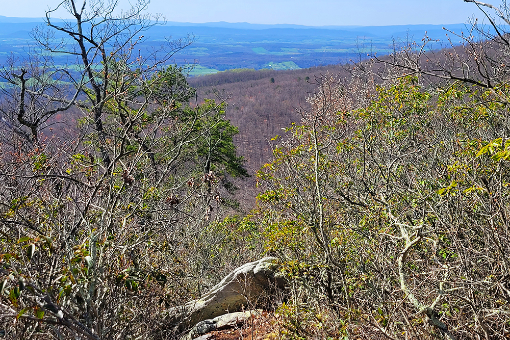
The terrain along the Appalachian Trail is varied and diverse. Some sections are smooth dirt, others are jagged and rocky. The vegetation along the trail is beautiful – alternating between lush expanses of fern, thick stands of mountain laurel and majestic groves of trees. Occasionally, the trail passes beneath a scenic overlook on Skyline Drive. Uphill from the trail, you can see families taking in park scenery from the comfort of their cars. Most of them never even notice us hiking below. I always wonder how many people visit the park and never leave the scenic byway. The best of Shenandoah is off the road, and so many people miss that.


The trail skirts around the western side of Hawksbill Mountain – Shenandoah’s tallest. Shortly after passing Hawksbill, a spur trail leads .1 miles down to two structures maintained by the Potomac Appalachian Trail Club (PATC). The Rock Spring Cabin is rented out by the PATC and is available to the general public. The cabin has a beautiful view of the valley beyond. We were lucky to run into a woman renting the cabin for the weekend, and she was kind enough to let us take a peek inside. The cabin was quite cozy and well equipped. The other structure in the area is the Rock Spring Hut. It’s a three-sided building with an elevated sleeping platform. A spring for fresh water and a privy are located close by. The hut was put in place to provide shelter to thru-hikers and section hikers along the Appalachian Trail. We took a few minutes to check out the journal at the shelter, and were able to find entries from the thru-hikers we met a few weeks ago.
After leaving the Rock Spring area, we saw a HUGE increase in traffic along the trail – Boy Scout troops, a busload of day hikers out for a leg-stretcher and various other parties. There are lots of easy access points to the trail in this area, so the traffic wasn’t completely surprising. This stretch of trail passes several nice overlooks from rocky ledges. By this point of the trail, clouds had really started to roll in. The weather was really odd on this hike. Skies went from perfect blue to stormy very quickly and the winds varied from dead calm to very brisk. The temperature stayed pleasantly cool – in the low 70’s, even though it was close to 90 in the valley below.
After walking across the Fisher’s Gap Overlook, the trail takes a distinct uphill turn toward the Big Meadows area. In the last mile, hikers ascend almost 700 feet in elevation. It’s the only tougher climb on the entire hike – most other ascents and descents are 200 feet or less. Near the end of the climb, the trail passes very close to the Big Meadows Campground. We were literally 25 feet or less from people’s tents and campers. After passing the campground, the trail levels out for the last few tenths of a mile before arriving back at the amphitheater.
It was a fun hike, and really quite easy for an 8-miler! We were also lucky to finish our hike before the thunderstorms roared across the mountains.
Adam Says…
Since Saturday was National Trails Day, we felt it was absolutely necessary to do a hike in one of our favorite places to hike – Shenandoah National Park. Since we’ve recently met a few thru-hikers, Christine suggested hiking the Appalachian Trail from Skyland to Big Meadows. June is a heavy month to encounter Appalachian Trail thru-hikers in Shenandoah National Park, since most start their trip in March or April. We ended up seeing nine thru-hikers on their way North to Maine. The few that we spoke to were looking forward to a big breakfast at the Skyland Lodge. Christine mentioned how crowded the trail was this day. This was mostly due to thru-hikers, boy scout groups, and tour groups. The boy scout group consisted of several parents that were along for the trip. The parents looked much more miserable than the scouts did themselves. In the bus group, one lady whispered to us as she passed, “I envy your freedom”, meaning that she wasn’t enjoying hiking in such a large group. As you near the Big Meadows Lodge and campground, you will likely see lots of people that are going for a hike, so travel on the AT nearby is one of the closest options for a hike. There was another pair of couples that were doing the lodge-to-lodge hike heading northwards, but I feel going from Skyland to Big Meadows does save you a little on the elevation gain (though the southbound route does save your largest uphill climb for last).
One of my highlights on the trail was walking along the talus slopes near the Hawksbill parking lot. We had completed a hike through the same area almost exactly one year ago to Hawksbill summit. It is impressive to view the talus slopes and watch out for peregrine falcons. We saw several swooping overhead from this point and we also saw some from the Franklin Cliffs overlook. If you are a bird lover, you will likely see some of the closest views of peregrine falcons in Virginia from here.
Due to the big storms we have had in the last few days, there was running water in a few spots on the trail. I wouldn’t expect this normally, but it could give some people an opportunity to fill up water bottles and treat the water if you are running low.


We ended the trip by stopping at the Big Meadows wayside for lunch. It was the most crowded I have seen the dining room in a while. We topped our lunch off with a dish of blackberry ice cream. This is something most thru-hikers have heard about and they can’t wait to try (especially the blackberry milkshakes). We then went over to talk to the volunteers at National Trails Day. There was an exhibition on two-person lumber sawing, information on safety, gear demonstrations and sign-ups for guided hikes. We talked to a few of the leaders from the Backpacking 101 course that were there on behalf of the Potomac Appalachian Trail Club. We had signed up to join the PATC last year at Trails Day. We were able to talk to our leaders for next weekend’s backpacking trip, so we were able to find out where we are going next week for our first backpacking trip. We’re quite excited! (more about that later)
On our way home, we saw a few fawns with their mothers. Most of the deer give birth in late May/early June, so they are quite tiny at this point in their lives. You will likely see hordes of photographers in Big Meadows trying to get pictures of the fawns, but I encourage people not to harass the wildlife by approaching too closely.
While this wasn’t the entire Appalachian Trail distance of 2175 miles, we enjoyed our small portion of the trail. We are hoping that we can hike the entire 105 miles of the AT that runs through Shenandoah National Park next summer.
Trail Notes
- Distance – 7.9 miles as a shuttle trail.
- Elevation Change – Constant ups and downs, but the longest uphill climb is about 650 vertical feet at the very end of the hike.
- Difficulty – 2. This is an easy hike for eight miles. The Appalachian Trail in Shenandoah is never very steep.
- Trail Conditions – 3. There are some rocky sections, but overall the trail is in great shape.
- Views – 3.5 – There are nice views from Timber Hollow, Hawksbill, Spitler Knob, and Franklin Cliffs.
- Waterfalls/streams – 0.
- Wildlife – 2. We know there is a lot of wildlife in this area, but we only saw the peregrine falcons soaring over Hawksbill Mountain.
- Ease to Navigate – 4.5. As long as you’re following the white blazes, you can’t go wrong.
- Solitude –1. We hiked this trail on a pleasant June morning. We saw *many* people – literally dozens and dozens.
Directions to trailhead:
On Skyline Drive, park at the Stony Man trailhead (located at the northern entrance to Skyland – near mile marker 42). You will see an Appalachian trail marker near the parking lot. You will see two AT cement posts, but the one that starts the trail is further away from Skyline Drive. Follow the trail south from this point.


 Wookie Says…


