Murphy-Chambers Farm – Harpers Ferry

This 2.2 mile route is more of a historic stroll than a true hike, but it’s definitely worth doing if you’re in Harpers Ferry and don’t have time for more significant hikes, like Weaverton Cliff, Loudon Heights or Maryland Heights.

Cannons on Murphy Farm
This short hike has a lot of interesting history. Below:  Meeting Jennifer Pharr Davis, Brew Davis and baby Charley; Berries on the trail; The beginning of the route.

ATC Talk Berries Trailhead

Adam Says…

We took a trip to Harpers Ferry, WV primarily to meet Jennifer Pharr-Davis, the current record-holder with the fastest time to hike the Appalachian Trail.  She was giving a talk at the Appalachian Trail Conservancy to promote her new book, Called Again,  and talk about her experiences hiking the Appalachian Trail.  The center holds archives of all the thru-hikers that have made it to this halfway point and while we waited for her talk to begin, we browsed around the center and looked through the photo archives to find some of our friends that had thru-hiked in years past.  We found Jennifer’s talk to be truly inspirational and she took several questions about her experience.

After leaving the center, we decided to take advantage of being in the area and headed to Harpers Ferry National Historic Park.  We drove up to the Visitor Center.  At the gate, there was a line of cars and one car was taking a long time to get through.  While I wasn’t feeling particularly patient either, the car in front of us was shouting for the car ahead to move along.  When this car finally got to the gate, they yelled at the park ranger for being too thorough with the other people’s questions.  They ended up just turning around since they were too mad to enjoy the park.  We felt so bad that the park ranger had to take this abuse.  We paid our $10 entry fee and parked near the Visitor Center.  We talked to the staff there and asked for an idea for a quick hike.  The staff member recommended this hike to us, since she said this had some of the nicest views of the Shenandoah River.  We filled up our water bottles and began our hike.

River View
A view of the river. Below; Stairs climb into the woods at the beginning of the hike; First views; Cannon

Steps View from Trail Cannon

The temperature was scorching this day and we hit the trail in the peak of the afternoon heat.  We both talked about how much we hate the heat of the summer.  Give me fall or spring hiking days any time over humid, hot summer days.

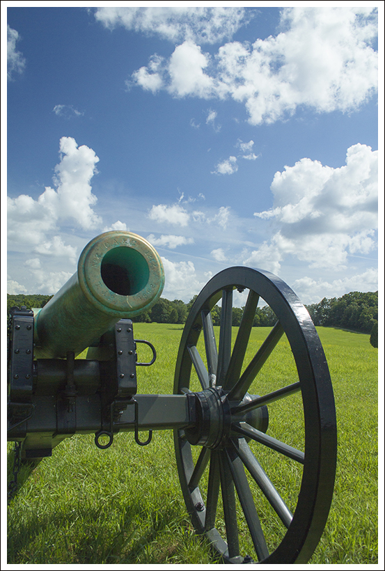
The trail starts from behind the restrooms of the Visitors Center and across the main road.  As soon as you cross the cross the road, the trail bears a sharp left, skirting the tree line.  The trail then goes deeper into the woods and begins a descent including a sharp switchback.  At about .25 miles, the trail crosses a bridge over the small creek and then begins a short climb uphill.  Once you reach the top, the trail opens up to houses on the right and a large field on the left.  We took a sharp left, which hugged the tree line down a path that was cut into the tall grass.  The shade of the trees gave us a little protection from the sun beating down, but it wasn’t quite enough.  At .5 miles, the trail approaches the back of the Murphy-Chambers House.  We decided to continue on and see the house on the return trip.  We continued along the trail and at .9 miles, we reached the John Brown Fort foundation.  John Brown was such an interesting character in American history and I remember writing a paper in college about his activist behavior.   A short distance from the foundation, the trail dips into the woods for the view of the Shenandoah River.  You get a nice view of the river and we weren’t surprised to see large rafts floating down the river.  We continued from this point to take a right at the next junction (rather than continuing on to the earthworks) to head back to the Murphy-Chambers House.  The trail follows a rather straight path and there wasn’t any shade to be found from the sun at this point.  At 1.2 miles, we reached an area of cannons and learned about how Confederate General A.P. Hill maneuvered his troops to a fortified position on this hill.

From here we continued on the trail which led to a gate keeping an unpaved road from going any further.  There is a parking lot here and a path to the right leads to the Murphy-Chambers House.  The Union took over this farm in 1862, ousting the Chambers Family.  While he tried to claim restitution for his property, there is no evidence that he was ever paid.  In 1869, Alexander Murphy re-established the farm.

We continued along the trail on the unpaved road until we reached the junction again that led back into the woods at 1.5 miles.  We followed the trail back to the Visitor Center and our car.  While the day was incredibly hot, it was nice to get out and stretch our legs and learn a little about the history that shaped this area.

Christine Says…

If the weather had been cooler or if we’d had more time, we would have opted to take one of the longer hike options in the area.  But after spending Saturday visiting Charlottesville-area wineries (Horton and Barboursville), touring James Madison’s Montpelier and enjoying a huge dinner at the Barbeque Exchange, we got a very late start on Sunday morning.  So late, in fact, that we were worried about making it to Jennifer Pharr Davis’ talk in time.  The original plan had been to have a leisurely lunch in downtown Harpers Ferry and then make our way to the ATC.  As it turned out, we ended up wolfing down Subway in Charles Town and making it to the talk just in time.

Murphy Farm
The Murphy-Chambers Farm; Adam checks out route options, John Brown historical site; Rafters

Checking the Map John Brown Historical Site Rafters

Jennifer’s talk was everything I hoped it would be and more!  I will never be a tenth of the athlete that she is, but she inspires me to get out there and challenge myself.  She loves the Appalachian Trail, and despite all the amazing places she has hiked, the AT is still her favorite.  Some people might think that setting a speed record on the trail would preclude appreciating or enjoying the beauty and the experience of nature.

But after hearing her speak and reading Called Again, I believe she found new levels of beauty, love, and personal fulfillment.  People hike the trail for a variety of reasons – to see scenery and wildlife, to engage in self-discovery, to challenge oneself physically or to form/deepen personal relationships.  Jennifer may have flown across the trail in a mere 46 days, but she still had all the experiences you would expect a person to have along the way.   I really enjoyed Jennifer’s first book Becoming Odyssa, but Called Again was even more rewarding.  I also added Brew Davis’ book (Jennifer’s husband) to my reading queue.  I expect his side of the story to be equally fascinating!

Fawn
We spotted a cute fawn. Below:  The return arm of the loop; Adam at the ATC.

Path ATC Adam

OK… now on to the hike!  Adam has already done such a thorough job describing the route and points of interest, that I really don’t have much to add.  I will echo his sentiments about the heat.  I felt like I was going to melt into a pool of sweat on the trail.  The day we were there was the beginning of one of the only really hot weeks we’ve had this summer. It was probably in the low nineties, but it was humid, windless and sunny, so the heat index was 101.  I really don’t like to hike when it’s above the mid 80s, so this wasn’t a particularly fun hiking day.  Even if there had been more time to explore the area, I don’t think I would have wanted to do a longer hike in this heat.

Nevertheless, I enjoyed the views of the river and the historical attractions.  If it had been cooler, I would have taken more time to read informational placards.  My favorite part of the hike was spotting a fawn grazing in the field.  From a distance, I saw a brown hump in the grass.  I asked Adam, ‘Is that an animal of some kind?’.  He thought it was a rock and headed over to read about the cannon on display.  I tiptoed along with my camera and found that the ‘rock’ was actually an adorable spotted fawn.  We made eye contact for a brief moment before he flashed his white tail and bounded off into the trees.

We made our way quickly back to the car where I chugged more water and blasted the air conditioning.  The outdoor temp thermometer on our car said 107.  I know that was mostly from leaving the car sitting in the sun… but still!  This short hike in the heat added even more to the anticipation about our upcoming ten day trip north!  Our next five posts are going to be out-of-staters!  We’ll be taking you to the rugged, exciting, spectacular high peaks of New Hampshire!

Trail Notes

  • Distance2.2 miles
  • Elevation Change – negligble
  • Difficulty –  1.  The trail was not very difficult and only had a little bit of elevation change on the hike.
  • Trail Conditions – 4.  The trail is well-established and didn’t have very difficult footing.  Most of the trail is on grass or gravel.
  • Views – 1.5.  The views of the Shenandoah River were somewhat obstructed with trees around. 
  • Streams/Waterfalls – 2.  You do get one heightened view of the Shenandoah River from this point.
  • Wildlife – 2.  I believe we were fairly lucky to see a fawn on the trail.  I would expect to see field birds here for any bird-watchers.
  • Ease to Navigate – 4.  The trails mostly inter-connect here, so you shouldn’t get lost.
  • Solitude – 4.  My guess is that most people that visit the Visitor Center do not hike up to this area, but you may see some people at the Murphy-Chambers House. 

Directions to trailhead:  From Charles Town, WV head north for about 4.5 miles.  Turn right on Shoreline Drive (about .8 miles past Millville Road).  The entrance fee station is just ahead and the large parking area is to the right.  Walk up to the Visitor Center and the trail is across the road behind the bathrooms.

Linville Falls (NC)

North Carolina Hikes

This wonderful little network of trails gives you the opportunity to view Linville Falls from every angle!  You can choose short/easy routes or longer/harder routes depending what you’re in the mood to do.  When all was said and done, we hiked a little over 3.5 miles and enjoyed several views of the falls.

View the full album of photo from this hike

Adam Enjoys a View of Linville Falls
Adam enjoys a bird’s eye view of Linville Falls. Below: The forest service information station; the trail network offers many options; beautiful blooming rhododendron.

Forest Service Info Station Trail Network Flame Azalea

Adam Says…

To finish our trip to North Carolina, we had to visit Linville Falls along the Blue Ridge Parkway.  While overcast days are better days for photographing waterfalls, we had to take what we were given.  The sun was high in the sky and it was quite hot on the hike, but we knew this wasn’t going to be too long of a hike.

We drove up the gravel Wiseman’s View Road and went first to the USFS Visitor’s Center.  Two women were inside and gave us some information on how to tackle the falls.  We were looking for a place to eat lunch before the hike and they recommended Famous Louise’s Rock House, especially for their pies.  We took their advice and refueled for the hike.  We ventured back up Wiseman’s View Road and parked in the large gravel lot at the to the left of the road.  The trail starts from the eastern side of the lot and begins with a steep descent.

At about .2 miles of a descent, we reached a junction.  We took a right here to make our way to the series of overlooks of the falls.  In a short distance, we reached another smaller junction with the trail to the Upper Falls, but we decided to approach that on the way back.  Since there are so many choices to make about the order in which you take in the views, I will not list all the distances; but you can tell from the downloaded map the distances to each.  We opted first to take a left for the trail to Chimney View, which provided a viewpoint to see the upper and lower falls.  From this point, we backtracked to the main trail and took a left.  Shortly, we came on to the side trail on the right for the Gorge View.  The views from here showed the canyon of the gorge but the views didn’t allow you to see the bottom of the canyon.  Next was the end of the main trail, which ended at Erwins View.  This view gave you the furthest view away from the falls, but it was still spectacular.  We backtracked and made our way back to the Upper Falls viewpoint.  From here, you could see the water plunge down the falls from a closer distance.

Upper Falls View
The upper falls view. Below: A view into the gorge; Adam hikes along.

Gorge View Linville Trails

From seeing people on the opposite side of the water and very close to the falls, we decided to take the trail down to the Linville Falls Visitor Center.  The trail was wide, road-like and going slightly downhill.  We eventually came to a bridge over the Linville River and the Visitor Center was on the opposite side.  We grabbed a few cold waters from the center and talked to the rangers about the trails on the other side.  We were fairly tired by this point, since we had done so much hiking during the week, but the temptation of the falls kept us pressing forward.  From the front of the Visitor Center, the trail headed into the woods on the eastern side of the building.  In a few feet, the trail branched and we took a right to head to the next overlook.  This trail branched off after about .3 miles.  We took a right at the junction, descending to reach the Plunge Basin overlook at .5 miles.  This point gave you a vantage point to see the water shoot through the gorge and down below.  We watched one man standing on the cliffside below, fishing from a precarious position.  We then made our way back to our car by returning to the Visitor Center, back across the bridge, and taking a right to the trail junction that led us back to our vehicle.

We had a great time visiting Linville Falls and this is definitely a hike that most people could do with their families.  A return trip in the peak of fall color with an overcast sky is something we will try to do.  While many waterfalls allow you to get very close to them, the trails here mostly keep you at a distance.  However, the view of the gorge with the waterfalls is breathtaking.

Christine Says…

Linville Falls was a perfect hike to end our trip through Tennessee and North Carolina – short and very easy! Ten hikes packed into eight days was pretty rigorous and I had the sore knees, bruises and sunburned arms to show for it!  Truth be told, I was secretly pleased that the ninth day of our voyage was stormy and rainy, because it meant we’d go home a day early instead of biking the 33+ miles of the Virginia Creeper.  Don’t get me wrong – I LOVE biking the Creeper, but I was exhausted from our whirlwind trip.  Maybe we ought to relax more on vacations – like normal people!  Nah…. probably not.  🙂

Linville Falls were a gift to the National Park Service from John D. Rockefeller.  So many of our favorite parks would not have existed without his generosity. Acadia, Shenandoah, Yosemite, the Grand Tetons, and the Smokies were all established, in part, due to his financial support.

Plunge View
The plunge view of the falls. Below: The Linville River; Beautiful desserts from Storie Street Grille.

Linville River Dessert

Adam did a thorough job describing all the different paths we took, so I don’t have a lot of details to add about the terrain. The only thing I would say is that you can walk to the bottom of the falls.  It’s about about .8 miles of hiking (some steep).  We opted to skip the view from the bottom on this trip, mainly because we were tired and could tell that the base of the falls was extremely crowded.

I enjoyed stopping in the visitors center and talking to the park ranger.  He was a pretty serious hiker and we enjoyed trading trail tips.  He suggested Crabtree Falls, NC for a future hike.  I was also fascinated by the cross section of an enormous tree hanging in the center. It fell when the Linville Gorge flooded in September of 2004. The hurricane-related flooding was so severe, that it washed away half of the visitor’s center and left many gigantic, toppled trees in its wake.  Water is such a powerful force!

Linville Falls has one of the highest water volumes of any waterfall in the Blue Ridge, so it’s not surprising that it floods so easily.  The high volume of water also makes the gorge perilous for people. Swimming is not allowed in the river near the falls, but numerous fatalities have still occurred in the area.

After finishing our hiking for the day, we retreated back to our cabin at the Pineola so we could get showered and dressed for dinner.  We decided to go fancy for our last evening in the area, and enjoyed a fabulous dinner at the Storie Street Grille in Blowing Rock, NC.  In addition to lovely outdoor patio seating, hey had a great wine line, beautifully prepared entrees, and amazing desserts.  Even though I’d already had pie a la mode earlier in the day, I could not pass up their dark chocolate – coconut bread pudding.  Adam’s banana creme brulee was equally delicious.  It was a fitting end to a fabulous trip!

Our next post will actually be a Virginia hike – shocking!  But then we’ll be going back to some more out-of-state posts.  We’re headed for the White Mountains of New Hampshire in a couple weeks, and are hoping to bring back at least a couple posts from that area.  Stay tuned!

Trail Notes

  • Distance – 3.65 miles
    (Check out the stats from Map My Hike)*
  • Elevation Change – 350 ft.
  • Difficulty –  1.  The trail does have a little climbing up and down on the trail, but most people should be able to do it without too much trouble.  We saw people of all ages and all levels of fitness on the trail, so it should be doable by anyone willing.  The options for different viewpoints allow for people to choose what they can handle and decide when to stop.
  • Trail Conditions – 4.5.  Most of the trail is either gravel or dirt and is well-worn.
  • Views – 4.  Great views of the gorge and waterfalls.
  • Streams/Waterfalls – 5.  There are many viewpoints to see the waterfalls.  The only challenge will be to enjoy it with few others around.
  • Wildlife – 1.  You may see squirrels and some birds flying around, but it would be unlikely to see much else.
  • Ease to Navigate – 4.   There is a large branching of side trails here, but using the map should guide you along.
  • Solitude – 0.  With such a close proximity to the Blue Ridge Parkway along with the ease of difficulty, this hike is crowded. 

Directions to trailhead:  From US 221, turn on to NC 183.  In .7 miles, turn right on to Wisemans View Road at the large curve.  The parking lot is a short distance on the left and the trail starts from the eastern side of the parking lot.

* MapMyHike is not necessarily accurate, as the GPS signal fades in and out – but it still provides some fun and interesting information.

The Beall Trails (WV)

The Beall Trails are a relatively short and flat figure-eight series of trails in Canaan Valley, West Virginia that provide open areas for viewing wildlife and a scenic walk along the Blackwater River.

Woods Along the Beall Trails
The woods along the Beall Trails are pretty and lush. Below: Flowers were still blooming at the end of summer; The area is part of a National Wildlife Refuge; Lots of deer inhabit the area of the Beall Trails.

Flower NWR Sign Deer

Adam Says…

This figure-eight loop trail was a great way to experience some early fall weather and scenery.  This trail doesn’t have a lot of elevation change, so it is doable by most people.  It is also a birdwatchers paradise if you hit the trail in the early morning.  The open fields and nearby Blackwater River make this an active spot for birds.

We parked at the parking lot and started by taking the South Beall trail.  The trail started off cut through grass.  There are a couple of signs that point to the left, but stay straight on the trail.  Eventually, you will approach an area that is wooded.  There is a sign here for a handicapped hunting shed, that hunters use for deer hunting.  The trail begins to loop away to the left near the sign and begins to descend towards the Blackwater River.  The trail hugs closely to the River and gives you a few views of the water before you ascend back up the trail.  You will eventually rejoin the trail.  Take a right and make your way back to the parking lot.

For the North Beall trail, the trail starts off instantly in the woods.  After a few tenths of a mile, it opens back up into a large field (where a large barn used to exist) and then brings you back into the woods.  The North Beall trail then continues to loop to the east, and then brings you on more of a fire road to take you back to your vehicle.

There is a Beall Connector trail that bisects the North Beall trail to make a shorter loop.  There is also a Bog Overlook Trail and Hemlock spur trail that are both out-and-back short trails if you wanted to add more to your hike.

One interesting thing that happened along our hike is that we heard and saw about 12 fighter planes streak across the sky at lower elevations and then bank hard over the nearby mountains.   The area is used for pilot training. I’m not sure exactly what type of planes these were, but they were definitely combat-type planes.  We tried to get some pictures, but whenever we heard them we were deep in the woods and couldn’t get a clear shot with the speed they were flying.

Black Swallowtail Caterpillar
A Black Swallowtail Caterpillar.  Below: Adam and Wookie walking along the trail; Wookie perches in a tree; Trail marker

Many Ferns Pug in a Tree Beall Trail Marker

On the fire road on the North Beall trail, shortly before returning to our vehicle, I spotted a bright green caterpillar.  We inspected it closely and it had large orange antennae.  We had never seen any caterpillar that was so bright and colorful before.   After returning home, Christine was able to identify it as a Black Swallowtail caterpillar.  It also gave off a strong stench when we picked it up on a stick.  It turns out that these caterpillars brighten up and secrete a chemical as a defense mechanism.  After getting a few close photos, we put it back down to let him travel along to one day become a gorgeous butterfly.

After our short hike, we made a trip into Davis, WV for lunch at Hellbender’s Burritos.  This was our first trip there, but the food was amazing!  Christine got the Gendarme burrito, which was similar to a Philly cheese steak and I got The Admiral, which had chicken and bacon.  We will definitely make this a must-stop place for lunch in the future.

Christine Says…

When Adam and I decided to get away to Canaan Valley for a long weekend, I thought we’d do a couple hikes, go for a bike ride and maybe take a ride up to Dolly Sods. In the end, it turned out to be a chilly, gray weekend, so we opted for just one really easy hike on the Beall Trails and lot of movies on DVD, crackling fires, pizza eating and wine drinking. It was nice to have such a relaxing weekend, but I am glad we did manage to get in one hike!

We decided to take Wookie along on this hike.  He really hasn’t been hiking much lately because of the summer heat.  He was beyond thrilled to accompany us.  When he saw us packing his leash and portable crate, he started spinning in circles and whining excitedly.  That dog loves outings more than any dog I’ve ever known!

Wookie Runs
Wookie runs on the South Beall trail.  Below: Leaves were starting to turn colors; A bluebird box on the trail.

Signs of Fall Bluebird Box
The Beall Trails, which essentially form a large figure-eight path, are part of the Canaan Valley National Wildlife Refuge.  The trails go across open meadows, through boreal forest and along a small stretch of the Blackwater River.  It’s very easy, mostly flat walking.  The trail is in great shape, so it’s really a suitable hike for all kinds of people.

We started off South Beall Trail.  Essentially, the path crosses a large open meadow before turning left into the woods and dropping down to the shore of the Blackwater River.  After following the river for a few tenths of a mile, the trail ascends quickly and returns hikers the same meadow path back to the parking area.  The river is lovely and in the meadow, you’ll likely see whitetail deer, wildflowers, birds and butterflies.  There are bluebird boxes around the meadow and an accessible hunting blind is located a short distance from the trail.

Along the Blackwater River
Stopping along the Blackwater River.  Below: Adam and Wookie make their way along the South Beall Trail; More pretty trail scenery.

Old Barn Field Along the Beall Trail

The North Beall Trail is a little bit longer and a little bit more densely wooded.  There is one distinctly open area a couple tenths of a mile into the trail.  The field used to house a beautiful, run-down old barn that we enjoyed exploring and photographing.  However in May of 2008, the barn was torn down to supply the barn timbers to the National Park Service for restoration projects at Antietem Battlefield.  I’m sure the wood from the Beall Barn lent a lot of authenticity to the battlefield projects, but I wish they had left the barn where it originally stood.  I wasn’t happy about them taking history from one place and falsely installing it in another.  It also took away the home of the owls that used to roost in the barn.  You can still read about the barn and the owls on the plaque at the trail entrance.  The interpretive sign about the barn was still there as of 2011. Oh well…

Even without the barn, the area is still very pretty and we enjoyed our short hike very much!

wookieWookie Says…

This was a great trail for a dog!  Even though it went along the river, I didn’t get wet or muddy at all.  I especially liked running in the open meadows!

Trail Notes

  • Distance 3.5 miles total.  1.4 miles for the South Loop and 2.1 miles for the North Loop
  • Elevation Change – about 100 feet
  • Difficulty – 1.5.  There is only one slightly steep climb on the South Loop.
  • Trail Conditions – 3.5.  The trail is maintained, but may be overgrown in some of the summer/fall months.
  • Views – 2.5.  You will get nice views of the mountains around you from the open fields, but this isn’t a hike for overlooks.
  • Streams/Waterfalls3.  On the South Loop, you do walk along the Blackwater River for some nice views between the trees.
  • Wildlife – 3.5  We saw a few deer on the trail, but the birdwatching on this trail is prime.
  • Ease to Navigate – 3.5.  This is an enclosed group of inter-connected trails, so you shouldn’t get lost.
  • Solitude – 4.5.  We’ve hiked this a few times and haven’t seen anyone. 

Directions to trailhead:  Heading north on Route 32 through Canaan Valley, WV, take a right on Cortland Road.  In about 1.5 miles, you will reach a one-lane bridge.  Nearby is the Canaan Valley sign that points to the short road that leads to the parking lot.  The parking lot is the center of the South and North Beall trails, so you can pick which one you would like to start first.

New River Trail – Fries to Foster Falls

The New River Trail is a 57-mile rails-to-trails bike path.  It starts in Galax or Fries and runs to Pulaski, following the New River closely for most of the way.  We biked a 20+ mile section from Fries to Foster Falls.

A Look Down the New River Trail
The trail was shady and lush! Below: One of the many bridges along the trail – this one crossed the New River;  A view of the New River at Foster Falls; Adam looks at some small rapids.

Bridge Near Shot Tower New River at Foster Falls Adam Looking at River

Adam Says…

When we were originally planning our trip down near the Grayson Highlands area, we were planning to incorporate a bike ride on the Virginia Creeper Trail.  We had previously done the Virginia Creeper Trail from Whitetop to Damascas, but we wanted to do the entire trail.  After doing some research, we found out that due to recent tornado activity, only 8 miles of trail is still available to bike south of Damascas.  There are plans to restore it soon, but it kept us from going with our original plan.

We were disappointed, but I had remembered hearing good things about the New River Trail.  After discovering that we could still stay near Grayson Highlands and do this trail, we had a solution.  The next challenge was trying to find a shuttle service to bike.  After doing some internet research, I found a place called New River Trail Outfitters that offers the service.  However, when I tried to call the numbers were disconnected.  I’m not sure if they are out of business, but I couldn’t find any current information for them.

Bike and Canoe Livery
The livery at Foster Falls rents bikes, canoes, kayaks and tubes. They also handle the bike shuttle service.  Below:  The stable at Foster Falls, A caboose on display; Foster Falls has an old depot building now used as a shop.

Stable Caboose Foster Falls Depot

I then called the New River Trail State Park and found out that they offer a shuttle service.  The park headquarters is located in Foster Falls.  The cost per person to shuttle from Foster Falls to Fries or Galax is $25/person.  When I called in for information, I found out they opened at 9AM.  When I asked if we needed to make a reservation, I was told “No.  You can  just show up.” It’s definitely much more laid back than making shuttle reservations for the Virginia Creeper. Along the Creeper, shuttles fill up days in advance, so you usually have to make a reservation with a credit card well ahead of your trip.

We decided to get there right at 9AM.  The day was calling for temperatures in the high 90s, so we wanted to get most of the bike ride over before the hottest part of the day.  We had to wait for a little while for a second employee to show up, but we were able to get our bikes loaded and we were off by about 9:20.  It took about 35 minutes to get to Fries.  We were thinking that it was going to be a very long bike ride, but the bike path is actually quite a bit shorter than the distance by car.

The New River Trail State Park is the longest state park, measuring a total of 57 miles, but only averages about 80 feet wide.  This is a state park with the purpose of biking, hiking, horseback riding, kayaking, or tubing.  The guys operating the shuttle service says that most people choose to rent kayaks and float the river along the trail.

Biking Across the Fries Junction Bridge
Biking Across the Fries Junction Bridge.  Below: A variety of scenery along the trail.

Cliffsides New River Old Barn

I would recommend getting a copy of the bike map to take along with you. This path that we chose mostly takes place in the south section, but you will be 1.2 miles in the north section.

We decided to go for the section from Fries to Foster Falls because we thought it would be a little more manageable in the heat than the Galax to Foster Falls section.  The Galax to Fries Junction section would have meant another 8 miles of biking and doesn’t parallel the New River until it reaches Fries Junction.

The bike path at Fries immediately starts by the New River.  Right from the parking lot, we were able to see gorgeous views of the river.  The trail takes about 5.5 miles to reach Fries Junction (which intersects with the trail from Galax).  At Fries Junction, we did run into about 10 camp counselors that were biking the trail and talking about which colleges they were admitted to.  I tried to keep quiet for a while, since I work in the JMU Admissions Office, but I did talk to one girl that was going to JMU next year as a freshman.  We pressed on after a short break, following the signs to Pulaski (the terminus of the trail).  We passed by Byllesby Dam (at mile 8.0) and Buck Dam (at mile 10.6).  We stopped to eat a snack at Ivanhoe (at mile 13.7).  Shortly after Austinville (at mile 16.5), we went through a short tunnel.  This tunnel wasn’t that dark, so you most likely would not need a headlamp to go through.  At mile 20.1, we reached Shot Tower.  We parked our bikes and hiked up the steep stairs (which is tough after biking a while) to explore the tower.  After we were done, we finished our ride back at the Foster Falls state park headquarters where we had started our trip.

There are a few geocaches to find along the way for this bike ride.

I definitely would like to come back and do some other sections of the trail.  The section from Galax to Foster Falls is about 28 miles and the section from Foster Falls to Pulaski is about 22 miles.  When we were reflecting back on the rails-to-trails bike rides we have done, we would put this only second to the Virginia Creeper trail.

Christine Says…

The New River Trail wasn’t our first choice for this mini vacation.  Initially, we had planned to head down to Abingdon and make a second attempt to bike the entire Virginia Creeper.  Let’s just say we don’t have good luck when it comes to the Creeper.  In 2009, it rained on us for 17 miles before we bailed out and caught a van ride back to Abingdon from Damascus, in 2010 I got bronchitis and was too sick to go when we planned, and in 2011 the section of the trail between Damascus and Abingdon was closed due to tornado damage.  Apparently, some mythical force is keeping us from finishing that trail!

Tunnel
This was the only tunnel we passed through on the section we biked.  Below: Geese and goslings; Pretty wildflowers along the trail; Rocks and rapids in the new river.

Geese Wildflowers Rapids

Luckily, Adam was able to do some last minute research and plan an alternate getaway for us that included biking along the New River Trail.  The trail is 57 miles long and passes through Grayson, Carroll, Wythe, and Pulaski Counties, linking the towns of Pulaski and Galax with a side spur of the trail linking to Fries.  It hasn’t been around as long as the Virginia Creeper, so it’s not as well-known and the area doesn’t have quite as many bike-friendly amenities (shuttle services, bike shops, trailside cafes).  But what it lacks in amenities, it makes up for with its beauty and solitude.   We saw fewer than two dozen people along the New River Trail over a 20+ mile span and greatly enjoyed the pristine river scenery.

The trail was in great shape – smooth and flat, covered with fine crushed stone.  There were lots of pretty wildflowers along the path – snapdragons, mountain laurel and others I didn’t know.  Every now and then, I’d catch a deer watching us quietly from the woods.  We saw a pair of geese and their goslings hanging out at one of the primitive trailside campsites.  The river was fed by many small streams cascading down the hillside above the trail.  There were even a few small waterfalls flowing.  The New River was spectacular!  All the spring rain had water levels higher than average, so there were many rapids and cascades that probably aren’t there when the water is lower.  The driver of our shuttle even mentioned that they had to cancel canoe/kayak/tube trips due to high water on the Saturday of Memorial Day weekend.

It was close to 100 degrees outside on the day we biked, so that made it a bit uncomfortable.  Although, once we got going, the breeze from pedaling along made the heat bearable.  Thankfully, much of the trail passes through a shady tunnel of woods, so we were able to stay out of the direct sunlight most of the way.

Nonetheless, I drank almost three liters of water and a 20-ounce bottle of lemonade over the course of the ride.  I also ended up with a huge, salty sweat ring on the front of my shirt (GROSS!) and my legs were crusted with sweat mixed with gravel and grit (DIRTY!).  I was not a pretty site at the end of the trail, but I had such a good time I didn’t care!

Shot Tower
The Shot Tower.

Two things I liked best along this bike path were the Fries Junction Bridge and the Shot Tower.  The bridge was neat just because it was so long and curvy.  Shot Tower was interesting for its history.  The tower itself sits above the trail.  So you have to take a short, steep climb up a hill and several flights of steps to visit the tower – but it’s definitely worth the effort.  Another little tidbit of history from the area is that Stephen F. Austin, ‘The Father of Texas’, was actually born in Wythe County, in a small town that now bears his name (Austinville).  The trail passes right through that area.

Horses
Park employees enjoy a shady spot on horseback.

I would definitely make a return trip to bike more of the New River Trail!  The state park shuttle service makes it so convenient.  I also might want to go back and ride horses along the trail.  Seeing all the horses at the Foster Falls stable really made me miss having a horse and going for long rides.

After finishing up with our bike ride, we got cleaned up and headed into Galax for a movie and pizza.  I was shocked that movies in Galax were only $4.00 for a matinee (as of 2011)!  After the movie, pizza at RJ’s Pizza and Subs was delicious!  They had really good and inexpensive food.

Trail Notes

  • Distance 21.3 miles
  • Elevation Change – negligible
  • Difficulty – 1.5  The terrain is extremely flat, so if you can do the mileage, you shouldn’t have a problem.
  • Trail Conditions – 4.5.  The trail is either very small gravel or dirt.  It doesn’t get better unless you find paved trails.
  • Views1.5  You don’t get views from high points, but there are a few nice unobstructed views of the river and some of the mountains around you.
  • Waterfalls/Streams – 5.  Most of the trail, you are biking along the New River.
  • Wildlife – 2.  We saw a couple of deer and a black snake on our ride.
  • Ease to Navigate –4.5.  The trail is very easy to follow and well-marked.
  • Solitude – 2.5.  This trail does get busy on nice weekend days, but it is not as popular as the Virginia Creeper trail.

Directions to trailhead: For the headquarters of New River Trail State Park for the shuttle service, take exit 24 (69 East) off of Interstate 77.  Take a left on to US-52 North.  Go 1.5 miles and take a right on to Foster Falls Road/State Route 608.  There should be signs directing you to the New River Trail State Park.  There is a fee of $2 to visit the park.

For the trailhead in Fries, VA, Fries is located off of  highway 94.   From Main Street in Fries, turn on Firehouse Drive.  You should see the small parking lot and bulletin board shelter for the start of the trail at the curve on Firehouse Drive.

Greenbrier River Trail – Cass to Marlinton (WV)

The Greenbrier River Trail is a rails-to-trails bike path that meanders 78 miles along the Greenbrier River in West Virginia. This portion we biked was about 25 miles from Cass to the little town of Marlinton.

Biking the Greenbrier River Trail
Adam crosses Sharps Bridge on the Greenbrier River Trail. Below:  Due to drought conditions, the Greenbrier River was very low;  Trail signs mark each entry to the trail; The Clover Lick Depot is one of the old train stops you’ll pass on the trail.

Adam on the River Greenbrier River Trail Sign with Bike Clover Lick Depot

Adam Says…

Our main reason for staying around the Marlinton, WV area was to do some biking on the Greenbrier River trail.  A few friends of mine that had done the Virginia Creeper Trail told me that we should do the Greenbrier River Trail sometime.  The trail was very similar to the Virginia Creeper.  They are both rails-to-trails biking trails and don’t take a ton of cardio effort or biking skills to complete.  The scenery may have been a little nicer along the Virginia Creeper; with mountain views and lots of bridges and trestles. However, the Greenbrier trail lacks the dense crowds that you find on the Virginia Creeper.  You’ll have lots of solitude on this trail, but there are also fewer amenities along the way (other than occasional restrooms at campsites).  Christine and I really enjoy the solitude more than anything, so it was great to get away for a nice, quiet, long bike ride.

We started our day with a car shuttle up to the northern terminus of the trail near Cass, WV.  We arranged the shuttle through Appalachian Sport.  We were the only people signed up for the shuttle, so we were able to arrange our own time.  It was nice to talk to our driver (wish we caught his name) about his impressions of the trail.  He was actually the one that gave us the news that JMU beat Virginia Tech in football.  We had been completely “off the grid” for a few days without any cellphone service, TV, or internet. We actually thought he was joking the first time he told us that JMU won.

Low Water Levels on the Greenbrier River
Water levels were very low on the Greenbrier River.  Below:  The trail follows the river for almost all of its 78 miles; Adam bikes along the crushed stone trail; A view of the lovely river.

The Greenbrier River Trail follows the river. Biking Along the Trail Greenbrier River Scenery

He frequently runs on the trail and told us about his goal to organize a Greenbrier River Challenge t0 raise funds with sponsorships for people to run the entire length of the trail.  A friend of mine from work is one of the few known people to run the entire trail in a single effort (I think he and a couple friends did all 78 miles in a little over 16 hours).  Our shuttle driver also told us that many people find the area between Cass and Marlinton to be the prettiest, but he thinks the entire trail is nice (with the exception of the more populated area between Marlinton and Seebert).

After being dropped off in the parking lot at the Northern Terminus of Slabtown (.5 miles from the town of Cass, WV), we got our gear together and headed down the trail.  Mile markers are posted along the way to help you plan your distance along the trail.  There are also slabs with the letter “W” along the trail, which were used by railroad engineers to know when to blow the whistle when they were approaching road crossings.  The first notable stop along the way is about 9.4 miles in when you reach the Clover Lick Depot.  This depot was built in the early 1900s and was recently renovated.  At mile 14.6, you will reach the Sharp’s tunnel and bridge.  The tunnel is 511 feet long and the bridge immediately after the tunnel is 229 feet long.  If you’re interested in parking your bike for a brief rest, right before the entrance to the tunnel there is a path to the left that leads down to the riverside. There is also a steep, slippery path up to the top of the tunnel for the more adventurous.  At mile 23.9, you will reach the water tank on the outskirts of Marlinton.  Shortly after you pass the water tank , you will reach the Marlinton Depot at mile 24.3.  The depot burned to the ground in 2008 and there are plans to have it rebuilt.  You can then bike a short distance back to where you left your vehicle.

Sharps Tunnel
The Sharps Tunnel is dark and deep!  Below:  Adam stands atop the tunnel entry;  By mid-day, big puffy clouds breezed into the sky.

Adam on top the Tunnel Entry Pretty Clouds Over the Greenbrier River

If you are interested in doing any geoaching along the bike trail, you can find a few along the way:

We definitely enjoyed our ride on the trail and I hope to come back at some point to try out some other sections of this trail.

Christine Says…

We had a great bike ride along the Greenbrier River Trail (GRT)!  I already can’t wait to go back and bike the remaining 53 miles.  Rails-to-trails riding is so pleasant and leisurely.  I love not having to worry about cars running me off the road.

If you’re going to bike a segment of the GRT, definitely look into arranging a shuttle. Typically, you leave your car at the end point, and the shuttle ferries you and your bikes to your start point. This allows you to bike a long section without having to retrace the trail to get back to your car.  You can also take your time exploring because you don’t have a set time to meet your ride at the end of your trip.  Shuttle companies are also a great source for trail tips – where to camp, where to eat, places to stop for water, etc.  We used Appalachian Sport, but there are several other shuttle companies in the area.

A View of Sharps Bridge
A View of Sharps Bridge.  Can you spot Christine on the trestle?  Below: A primitive campsite along the trail; Adam drives the old wagon; A few early hints of fall were evident in the trees along the trail.

Campsite Along the Trail Adam Driving the Old Wagon Biking Along

We met our shuttle at 8:30, loaded up our bikes and headed off on our 45-minute van ride to Cass.  The morning was still cool with thick mist lifting off the river.  Fall is definitely in the air!  We passed through Cass Scenic Railroad State Park on our way to the northern end of the GRT. Cass is near Snowshoe Mountain.  The area offers so many options for outdoor fun – skiing, mountain biking, canoeing, scenic railroads, fishing, hiking, etc.

By 9:30, we were off and pedaling along the trail.  For several miles, we followed along the river – no sign of roads, people or houses.  It was wonderful!  The river was really low, but it was still gorgeous.  Every now and then, a deer would bound across the trail or go splashing across the river.  The fog burned off and opened up to crystalline clear blue skies – not a cloud in site.  Early splashes of fall color were already evident in the trees along the trail.

We passed a couple trailside campsites.  The GRT is also popular with equestrians, so campsites all included hitching posts. If I still had my horse, this would definitely be a dream ride!  Several of the campsites even had privies.

Occasionally, the trail passes by developed areas.  But “development” in this section of West Virginia usually means a few houses clustered along a quiet country road.  We passed a barn with equestrian services advertised on the building side.  They also had an old horse cart that Adam couldn’t resist.  We passed the Clover Lick Depot.  I think this area was probably a lot busier when the train was still running.  The depot building was really cute and had recently been restored.  Sadly, it’s not being used for anything.  I bet it would make a great trailside gift and snack shop, but I also bet it would be nearly impossible for a shop to stay in business along the GRT.  In the entire 25 miles we biked, I think we saw 6 people all day long.  With such low traffic, amenities will never spring up along this trail like they have along the Virginia Creeper.

One of my favorite things we passed along – or shall I say through – was the old Sharps Tunnel.  When we arrived at the tunnel opening, Adam scrambled up the hill to the top of the tunnel opening.  You can smell the inside of the mountain emanating from the tunnel.  It’s a hard smell to describe – the best I can describe is like a cool wind carrying the scent of tar, dampness and earth.  The tunnel is over 500 feet long and follows a curve.  This means that there is a section in the middle where there is absolutely no ambient light.  It is 100% completely pitch black and eerie as the grave.  For a few moments, I lost all sense of up, down, forward and backward.  It was like biking in space!  I shrieked with a mix of fear and giddiness until my bike hit light again.  It was really fun, but if you’re afraid of the dark or an uncertain biker, you might want to have a light on your bike or carry a headlamp in your bag.

There were a bunch of state park employees eating lunch on the other side of the tunnel.  I think they all heard me screaming in the tunnel, because they looked at me oddly.  Oh well…  I hope they were entertained.  As soon as you come out of the tunnel, you pass over the Sharps Bridge, which crosses the Greenbrier River on a tall trestle.

Baby Chipmunk
We spotted a couple of frightened baby chipmunks along the trail.  Below: Another view of Sharps Bridge; the Greenbrier River; The other baby chipmunk we spotted.  I hope they survived.

Another look at the trestle and Sharps Bridge Greenbrier River View The other chipmunk

Shortly after crossing the bridge, I saw a tiny animal dart across the trail – barely missing Adam’s bike wheels.  It was as small as a field mouse.  I braked when I saw the tiny creature still sitting along the trailside.  It turned out to be a tiny baby chipmunk.  It was too young to be away from the nest, and the mother chipmunk was nowhere in site.  We made sure the little guy was safely off the trail and headed on our way.  As Adam was walking back to his bike, he almost stepped on another baby chipmunk.  This one was sitting in the middle of the trail, trembling in fear.  We made sure the other chipmunk was safely off the trail and nestled under some leaves before we biked on.  I hope those little chipmunks somehow found some way to survive.  😦

Chipmunks and deer were not the only wildlife we saw along the way.  We also saw a couple different kinds of snakes.  One snake was the largest black snake I’ve ever seen!  He was lying half on and half off the trail, clearly in a state of torpor from the chilly weather.  At first, I thought it was a toy rubber snake that someone had tossed along the trail.  It didn’t move at all when I nudged it with a stick.  I pushed it again, and I noticed the body slowly constricting.  The stick I had was an old fallen tree branch – about eight feet long.  I pushed the snake again to get it off the trail, but this time the snake completely coiled up; raising its upper body off the ground and flicking its tongue at me.  He was still really slow and stiff, but definitely awake! Adam, who was sitting on his bike 50 feet away, wanted nothing to do with the snake at all.  Finally, I managed to push the snake completely off the trail into the grass.  Hopefully, he slithered away when the sunshine of the day warmed him up.  Later in the day, we saw another snake basking in the sun in the middle of the trail, but he moved out of the way really quickly.

Huge Black Snake
We saw this sleepy (but angry) black snake on the trail. Below:  Near Marlinton, we saw old farm buildings and fields; The old water tank;  The burned Marlinton depot; Adam checks out the inside of the train.

Old Farm Building Water Tank near Marlinton
Burned Marlinton Depot Adam Checks out the Train

The last few miles of the trail passed through more open terrain.  We saw fields and old abandoned farm buildings.  Shortly thereafter, we passed a huge water tank – the only one left standing along the trail.  Trains used to stop at this spot to fill up.  By the time you get to the water tank, the GRT switches from a crushed stone surface to paved.  The paved section is about five miles long.

In a few minutes, we were back in Marlinton at the old train depot.  The depot used to be the town visitor’s center, but as Adam mentioned, it burned down a few years ago.  We took a few minutes to climb aboard the old train car at the depot before heading back to our car.

After loading up, we had a delicious lunch at the Greenbrier Grille.  They had great sandwiches (I recommend the Steak & Mozzarella!) and a lovely deck overlooking the river.  We ate lunch to the sound of honking ducks in the river below.  The restaurant has a large menu of homemade desserts, but we were too full from the sandwiches.

The next day, we were on our way back to Virginia, but we’ll definitely be visiting Pocahontas County again!

Trail Notes

  • Distance – 24.3 miles
  • Elevation Change – Negligible.  Hardly any elevation change.
  • Difficulty – 2. While the biking is not difficult, the distance might be a little much for some people.  Hiking or biking it should be fairly easy.
  • Trail Conditions – 4.5 The trail is very well-maintained.
  • Views3.  The trail is scenic through most of the trail with views of the river most of the time.
  • Waterfalls/streams – 2. The path runs along Wilson Creek for part of the trip and the Greenbrier River for most of the trip.
  • Wildlife – 2.5 We saw deer a few times on the trail and in the river.  We also spotted some baby chipmunks, a blue heron, a couple snakes and some geese.
  • Ease to Navigate – 4.5. Just stay on the bike trail.  A few spots run parallel with other driveways/roads, but you shouldn’t have trouble if you stay on the trail.
  • Solitude – 3.  We were surprised with how few people were on the trail biking.  I think we only saw 6 people biking on the trail the entire day.

Directions to trailhead: The actual trailhead is located off Route 66/Back Mountain Road near Cass, WV.  There are clear signs to direct you to the trail.

View a Google Map of the Route