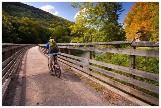
The Greenbrier River Trail is a rails-to-trails bike path that meanders 78 miles along the Greenbrier River in West Virginia. This portion we biked was about 25 miles from Cass to the little town of Marlinton.

Adam Says…
Our main reason for staying around the Marlinton, WV area was to do some biking on the Greenbrier River trail. A few friends of mine that had done the Virginia Creeper Trail told me that we should do the Greenbrier River Trail sometime. The trail was very similar to the Virginia Creeper. They are both rails-to-trails biking trails and don’t take a ton of cardio effort or biking skills to complete. The scenery may have been a little nicer along the Virginia Creeper; with mountain views and lots of bridges and trestles. However, the Greenbrier trail lacks the dense crowds that you find on the Virginia Creeper. You’ll have lots of solitude on this trail, but there are also fewer amenities along the way (other than occasional restrooms at campsites). Christine and I really enjoy the solitude more than anything, so it was great to get away for a nice, quiet, long bike ride.
We started our day with a car shuttle up to the northern terminus of the trail near Cass, WV. We arranged the shuttle through Appalachian Sport. We were the only people signed up for the shuttle, so we were able to arrange our own time. It was nice to talk to our driver (wish we caught his name) about his impressions of the trail. He was actually the one that gave us the news that JMU beat Virginia Tech in football. We had been completely “off the grid” for a few days without any cellphone service, TV, or internet. We actually thought he was joking the first time he told us that JMU won.

He frequently runs on the trail and told us about his goal to organize a Greenbrier River Challenge t0 raise funds with sponsorships for people to run the entire length of the trail. A friend of mine from work is one of the few known people to run the entire trail in a single effort (I think he and a couple friends did all 78 miles in a little over 16 hours). Our shuttle driver also told us that many people find the area between Cass and Marlinton to be the prettiest, but he thinks the entire trail is nice (with the exception of the more populated area between Marlinton and Seebert).
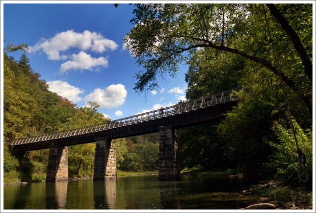
After being dropped off in the parking lot at the Northern Terminus of Slabtown (.5 miles from the town of Cass, WV), we got our gear together and headed down the trail. Mile markers are posted along the way to help you plan your distance along the trail. There are also slabs with the letter “W” along the trail, which were used by railroad engineers to know when to blow the whistle when they were approaching road crossings. The first notable stop along the way is about 9.4 miles in when you reach the Clover Lick Depot. This depot was built in the early 1900s and was recently renovated. At mile 14.6, you will reach the Sharp’s tunnel and bridge. The tunnel is 511 feet long and the bridge immediately after the tunnel is 229 feet long. If you’re interested in parking your bike for a brief rest, right before the entrance to the tunnel there is a path to the left that leads down to the riverside. There is also a steep, slippery path up to the top of the tunnel for the more adventurous. At mile 23.9, you will reach the water tank on the outskirts of Marlinton. Shortly after you pass the water tank , you will reach the Marlinton Depot at mile 24.3. The depot burned to the ground in 2008 and there are plans to have it rebuilt. You can then bike a short distance back to where you left your vehicle.

If you are interested in doing any geoaching along the bike trail, you can find a few along the way:
- Clover Lick Depot
- Katy’s Cache on GRT
- Are We Alone? GRT – part of the National Radio Astronomy Observatory SETI@50 geocaching event
We definitely enjoyed our ride on the trail and I hope to come back at some point to try out some other sections of this trail.
Christine Says…
We had a great bike ride along the Greenbrier River Trail (GRT)! I already can’t wait to go back and bike the remaining 53 miles. Rails-to-trails riding is so pleasant and leisurely. I love not having to worry about cars running me off the road.
If you’re going to bike a segment of the GRT, definitely look into arranging a shuttle. Typically, you leave your car at the end point, and the shuttle ferries you and your bikes to your start point. This allows you to bike a long section without having to retrace the trail to get back to your car. You can also take your time exploring because you don’t have a set time to meet your ride at the end of your trip. Shuttle companies are also a great source for trail tips – where to camp, where to eat, places to stop for water, etc. We used Appalachian Sport, but there are several other shuttle companies in the area.

We met our shuttle at 8:30, loaded up our bikes and headed off on our 45-minute van ride to Cass. The morning was still cool with thick mist lifting off the river. Fall is definitely in the air! We passed through Cass Scenic Railroad State Park on our way to the northern end of the GRT. Cass is near Snowshoe Mountain. The area offers so many options for outdoor fun – skiing, mountain biking, canoeing, scenic railroads, fishing, hiking, etc.
By 9:30, we were off and pedaling along the trail. For several miles, we followed along the river – no sign of roads, people or houses. It was wonderful! The river was really low, but it was still gorgeous. Every now and then, a deer would bound across the trail or go splashing across the river. The fog burned off and opened up to crystalline clear blue skies – not a cloud in site. Early splashes of fall color were already evident in the trees along the trail.
We passed a couple trailside campsites. The GRT is also popular with equestrians, so campsites all included hitching posts. If I still had my horse, this would definitely be a dream ride! Several of the campsites even had privies.
Occasionally, the trail passes by developed areas. But “development” in this section of West Virginia usually means a few houses clustered along a quiet country road. We passed a barn with equestrian services advertised on the building side. They also had an old horse cart that Adam couldn’t resist. We passed the Clover Lick Depot. I think this area was probably a lot busier when the train was still running. The depot building was really cute and had recently been restored. Sadly, it’s not being used for anything. I bet it would make a great trailside gift and snack shop, but I also bet it would be nearly impossible for a shop to stay in business along the GRT. In the entire 25 miles we biked, I think we saw 6 people all day long. With such low traffic, amenities will never spring up along this trail like they have along the Virginia Creeper.
One of my favorite things we passed along – or shall I say through – was the old Sharps Tunnel. When we arrived at the tunnel opening, Adam scrambled up the hill to the top of the tunnel opening. You can smell the inside of the mountain emanating from the tunnel. It’s a hard smell to describe – the best I can describe is like a cool wind carrying the scent of tar, dampness and earth. The tunnel is over 500 feet long and follows a curve. This means that there is a section in the middle where there is absolutely no ambient light. It is 100% completely pitch black and eerie as the grave. For a few moments, I lost all sense of up, down, forward and backward. It was like biking in space! I shrieked with a mix of fear and giddiness until my bike hit light again. It was really fun, but if you’re afraid of the dark or an uncertain biker, you might want to have a light on your bike or carry a headlamp in your bag.
There were a bunch of state park employees eating lunch on the other side of the tunnel. I think they all heard me screaming in the tunnel, because they looked at me oddly. Oh well… I hope they were entertained. As soon as you come out of the tunnel, you pass over the Sharps Bridge, which crosses the Greenbrier River on a tall trestle.

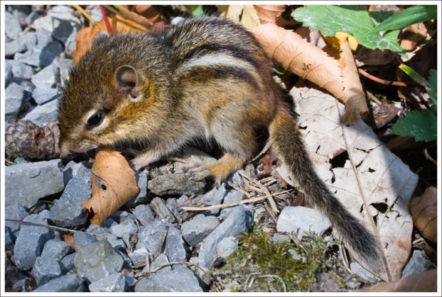
Shortly after crossing the bridge, I saw a tiny animal dart across the trail – barely missing Adam’s bike wheels. It was as small as a field mouse. I braked when I saw the tiny creature still sitting along the trailside. It turned out to be a tiny baby chipmunk. It was too young to be away from the nest, and the mother chipmunk was nowhere in site. We made sure the little guy was safely off the trail and headed on our way. As Adam was walking back to his bike, he almost stepped on another baby chipmunk. This one was sitting in the middle of the trail, trembling in fear. We made sure the other chipmunk was safely off the trail and nestled under some leaves before we biked on. I hope those little chipmunks somehow found some way to survive. 😦
Chipmunks and deer were not the only wildlife we saw along the way. We also saw a couple different kinds of snakes. One snake was the largest black snake I’ve ever seen! He was lying half on and half off the trail, clearly in a state of torpor from the chilly weather. At first, I thought it was a toy rubber snake that someone had tossed along the trail. It didn’t move at all when I nudged it with a stick. I pushed it again, and I noticed the body slowly constricting. The stick I had was an old fallen tree branch – about eight feet long. I pushed the snake again to get it off the trail, but this time the snake completely coiled up; raising its upper body off the ground and flicking its tongue at me. He was still really slow and stiff, but definitely awake! Adam, who was sitting on his bike 50 feet away, wanted nothing to do with the snake at all. Finally, I managed to push the snake completely off the trail into the grass. Hopefully, he slithered away when the sunshine of the day warmed him up. Later in the day, we saw another snake basking in the sun in the middle of the trail, but he moved out of the way really quickly.

The last few miles of the trail passed through more open terrain. We saw fields and old abandoned farm buildings. Shortly thereafter, we passed a huge water tank – the only one left standing along the trail. Trains used to stop at this spot to fill up. By the time you get to the water tank, the GRT switches from a crushed stone surface to paved. The paved section is about five miles long.
In a few minutes, we were back in Marlinton at the old train depot. The depot used to be the town visitor’s center, but as Adam mentioned, it burned down a few years ago. We took a few minutes to climb aboard the old train car at the depot before heading back to our car.
After loading up, we had a delicious lunch at the Greenbrier Grille. They had great sandwiches (I recommend the Steak & Mozzarella!) and a lovely deck overlooking the river. We ate lunch to the sound of honking ducks in the river below. The restaurant has a large menu of homemade desserts, but we were too full from the sandwiches.
The next day, we were on our way back to Virginia, but we’ll definitely be visiting Pocahontas County again!
Trail Notes
- Distance – 24.3 miles
- Elevation Change – Negligible. Hardly any elevation change.
- Difficulty – 2. While the biking is not difficult, the distance might be a little much for some people. Hiking or biking it should be fairly easy.
- Trail Conditions – 4.5 The trail is very well-maintained.
- Views – 3. The trail is scenic through most of the trail with views of the river most of the time.
- Waterfalls/streams – 2. The path runs along Wilson Creek for part of the trip and the Greenbrier River for most of the trip.
- Wildlife – 2.5 We saw deer a few times on the trail and in the river. We also spotted some baby chipmunks, a blue heron, a couple snakes and some geese.
- Ease to Navigate – 4.5. Just stay on the bike trail. A few spots run parallel with other driveways/roads, but you shouldn’t have trouble if you stay on the trail.
- Solitude – 3. We were surprised with how few people were on the trail biking. I think we only saw 6 people biking on the trail the entire day.
Directions to trailhead: The actual trailhead is located off Route 66/Back Mountain Road near Cass, WV. There are clear signs to direct you to the trail.


enjoyed reading about the grt. we are doing it in oct 22
LikeLike
My son is a train fanatic. We visit Cass about once a year. Biking is my thing! I will definitely bring my bike this July!! Thank you for the write up! I never knew in the three years we’ve been going here that this existed!
LikeLike
Enjoy the ride, Eddie! It’s a beautiful one!
LikeLike
Enjoyed reading your posts. Convinced us to visit Marlinton and take shuttle to Cass.
Hope to go the end of June or beginning of July. Can’t wait.
LikeLike
Enjoy! We loved that trip. I hope you will too.
LikeLike
Enjoyed the post and pictures. I ‘m leaving Florida in late Sept and will make my camp in the Marlington area. This will allow me to bike to the north terminus and back and the next day I can bike the south trail. Looking forward to this ride.
LikeLike
Enjoy! September should be a nice time to ride the trail!
LikeLike
Enjoyed your post, we are planning to ride the trail in June for my 70th birthday, 70 miles at 70 years, great! We plan to stay in Marlinton and use the shuttle.
LikeLike
You will have a great time! It’s a beautiful trail.
LikeLike
Great description of this part of the trail. My (then) 9 year old son and I biked in 2009 from Marlinton to Sharp’s and back and your entry brought back some of the enjoyment of that great day. He will be glad to see that the rope swing still exists next to Sharp’s Tunnel. And I cannot wait until he is older so we can get a group of his buddies to bike and camp along the full route. And then there is the North Bend Rail Trail, and the bike trail from DC to Pittsburgh… So many great possibilities, so little time!
LikeLike
Thanks for the visit! Yeah – there are so many great rails to trails options. It’s such fun terrain to bike. We can’t wait to go back and do the rest of the GRT.
LikeLike
Great post Christine and Adam… wonderful photos!
LikeLike
Thanks for the visit, Aaron!
LikeLike