
Introductory Guide to Visiting Great Smoky Mountains National Park
This eleven mile hike of Mount LeConte is beautiful and lots of fun! The scenery is diverse – streams, views, towering bluffs, an arched rock that you get to climb through, and a visit to the famous LeConte Lodge.
View the full album of photos from this hike


Adam Says…
When we were planning our trip to Great Smoky Mountains National Park, the hike that we were most excited to do was the hike up Mount LeConte. We hiked this trail last year by taking the Trillium Gap Trail, so it was time to try an alternate route. Last time we had talked to several people that had taken the Alum Cave trail, so we thought it may be a good option.
The weather was gorgeous this day, but we knew we had a chance for thunderstorms in the afternoon, so we decided to get as early of a start as we could. When we had hiked up via the Trillium Gap Trail, we didn’t run into a lot of hikers; however, it was evident early on this route was going to be a different story. While Christine was taking advantage of the facilities near the trailhead, I was getting nervous as I saw large groups of people starting the trail. We’re fairly fast hikers and I was worried we were going to get stuck in a jam behind families with small kids that would slow us down. Christine arrived and we got on our way.
We both jumped into the hiking and started hiking at a frenetic pace. We wanted to get in a spot that was far enough ahead of others where we could stop periodically and snap some photos. It took us a while to get separated from the larger groups, so we didn’t take as much time to enjoy the scenery in the first mile. We convinced ourselves that we could have more time to amble along on the return trip.


The trailhead starts from the Alum Cave Bluff parking lot on US-441. At the trailhead, there is a larger map and some trail information guides you can purchase for $ .50. You will immediately cross a bridge over the Walker Camp Prong stream. The trail starts off very flat, but you know you’ll have lots of climbing to do later on in the hike. The first mile of the hike goes along the Alum Cave Creek. There are several options to jump slightly off the main trail to take in the scenes of the cascading creek. At 1.4 miles, you will reach a footbridge to cross Styx Branch before you reach the interesting geological feature known as Arch Rock. Arch Rock is basically a hollowed-out rock tunnel. You will climb up some steep stairs with a guideline as you go through to the top. Once you emerge out of the top, you go a little further and then reach another footbridge to cross Styx Branch one more time.
The trail begins to climb more steeply at this point as you make your way to Alum Cave Bluffs. At 2.4 miles, you start to come across a larger rock outcropping. As the trail starts to climb around this, you behold the enormous Alum Cave Bluffs. With the word “cave” being in the title, your initial expectations would be a large cave would be here. However, the cave bluffs are basically a humongous rock overhang. It is still jaw-dropping impressive and unlike anything I’ve seen. The ground underneath is dry and dusty. We saw a few drops of moisture come over the edge, but the overhang reaches out about 60 feet. Standing at one end of the outcrop looking at people at the other end, gives you a perspective of how large of an area this is.

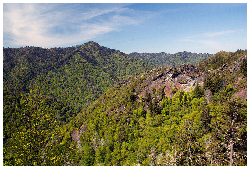
From the Alum Cave Bluffs, you will see a sign that shows the direction to continue up Mount LeConte. The trail climbs steeply for the next .4 miles, passing some views of Little Duck Hawk Ridge. The trail reaches a peak and then descends into a saddle for another .4 miles. The trail begins to climb again rather steeply for a good portion of the remainder of the hike as you make your way up the mountain. Along the way, you will pass by a rock slide, which opens up to some gorgeous views with nothing but layers of mountain ridges to see. At 3.8 miles, you reach a set of stairs on a switchback to continue your climb. The trail eventually comes into a steep, rocky climb with cables put in to use as handrails (since this trail gets very icy with little sun in the winter).
The trail finally starts to level off at mile 4.75 as you enter into a tunnel of fraser fir trees. Continue on a short distance and then you’ll reach a junction with the Rainbow Falls Trail. Continue a few hundred feet and you’ll reach the LeConte lodge.
Getting a spot at the LeConte Lodge is competitive and highly coveted by Smokies visitors. Reservations are made by lottery and typically start booking in early October for the following year, so it takes some planning and a little luck to be able to stay in one of these spots on top of the mountain. We were lucky enough to get a spot here last year and we hope that we’ll do it again in the future.


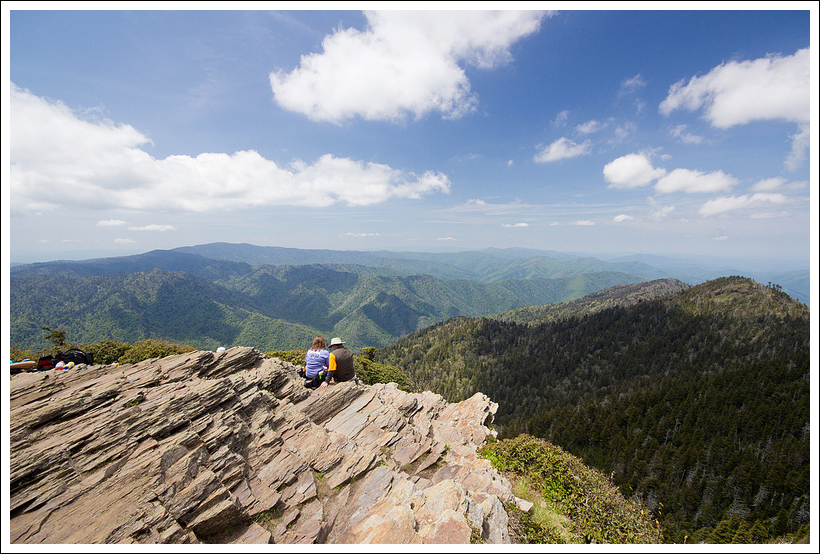
From the cabin area, we wanted to get some nice views and headed up the main path until we reached a junction. Hang to the right to go to the Cliff Top trail. This trail is rocky and quite steep. The sign says that it is .2 miles to the top, but it feels longer than that. However, when you get to the Cliff Top area, you will have great views for miles on a clear day. After taking in the views, we grabbed a sack lunch from the dining room to refuel for our trip back down. We talked with some fellow hikers at the top and relaxed for a while. After staying up there a previous year, it was hard to motivate ourselves to head back down.
On our way back down, the trip went by fairly quickly since everything was downhill. It’s always interesting when you see people hiking uphill that look like they are in complete misery. We spotted one woman, who was staring daggers at her husband (who I’m guessing convinced her to go hiking). Her daughter was hanging back with her and said, “I love you, mom”. The mother’s response was, “That’s nice”. She was definitely not having a good time hiking. We imagined how the father was going to get an earful for the rest of day.
If you are interested in geocaching, there are not a lot that are available in Great Smoky Mountains National Park since the national park prevents physical caches from being placed. However, there is a virtual cache on the trail to find – Alum Cave Bluff.
Christine Says…
Monday morning dawned in spectacular fashion. It was cool, sunny and crystal clear. Even the typical haze that makes the Smokies seem smoky was absent. That was such a treat, because clear air really lets you appreciate the magnificent, green, lushness of the mountains in this area.
We kicked off our morning with breakfast at Mountain Perks – a little café and espresso bar across from the train depot in Bryson City. The owners, Jeff and Pam Pulley are so friendly and are ready to serve local tips alongside their tasty breakfast and even better coffee. I left there with a pound of their ‘Black Widow’ roast coffee to enjoy at home after the trip.
Fully fed and caffeinated, we made our way into the park. On the way to the Alum Cave Bluff trailhead, we spotted a couple elk grazing in a pasture just north of the Occonaluftee visitor center. What a treat!


We got to the Alum Cave Bluff parking area around 9:30, and found that it was already 100% full. We had to park a ways up the road on a pullout. We geared up, and hit the trail – along with dozens and dozens and dozens of other people. I’ve rarely hiked with so many people on the trail at the same time – even on Old Rag. I’ll admit, it made me a little stressed. As you might have guessed, I stop frequently to take photos along the way. Also, Adam and I are relatively fast hikers. So, when I stop to take photos, we end up leap-frogging the same people over and over again. That’s not a problem when there are only a few groups on a trail, but coming up on the heels of large multi-generational families time after time makes me feel bad. It’s easy to pass a couple, it’s more disruptive to squeeze past ten people, six of them kids under the age of ten. I probably didn’t take as many photos early in the hike as usual so that I could avoid being disruptive.
The first couple miles of the hike were relatively easy, following a stream and climbing very gently through the moss covered forest. The terrain changed when we reached Arch Rock. After crossing a log footbridge, stone steps led uphill steeply through an arch of stone. Very cool!
After the arch, the trail began to climb more steeply. In several places, wire was affixed to the rocky side of the trail to help you keep your footing over narrow, slick areas. We climbed uphill for about .7 of a mile before reaching the famous Alum Cave Bluff. Along the way, the trail alternated between rocky and forested. There was even one nice view on a rocky, sand myrtle-covered turn in the trail.
WOW! I had seen photos of the Bluffs, but they were even more impressive in person. The rock wall soared and arched overhead, forming an immense overhang. The terrain beneath the arch was dry and silty. It was tough to walk on and I imagine this area is tough to traverse when it’s wet and rainy.


I think a good number of people stop at the Bluff and then return to the parking area, so the trail traffic was much lighter after passing that area. We pressed on toward the summit of LeConte.
After the Bluff, the climbing is serious and steady. There are also a number of great views along the way. The Smokies really take my breath away. I kept thinking about how lucky and blessed I am to visit such places and have the physical capability to enjoy the tough climbs.
Eventually the trail turned a corner and leveled out and passed arrow-straight through an evergreen forest. The trail bed looked almost like cobblestones – white, round, smooth rocks. From that point, we had an easy .75 mile walk until we arrived at LeConte lodge.
At LeConte, we did all the obligatory things – took our photo in front of the dining hall with the elevation marker/date, said hello to the llamas, visited the office to get our exclusive summit-shop-only 2013 shirts, sat on rocking chairs, drank copious amounts of LeConte lemonade with our bagged lunches and made the .2 mile climb to enjoy the view from Cliff Tops.
Being at the top on a nice day was such a different experience than our 2012 visit in the rain! However, as the afternoon wore on, we noticed that some darker clouds were starting to build in the sky. We headed back down after about an hour at the summit.
The hike down went very quickly – all downhill! It’s amazing how much faster you can descend 2700 feet than you can climb it! We saw several cute red squirrels that took the time to chatter loudly at us. We scared a grouse from it’s resting spot – and the grouse scared us equally back! They really explode out of the brush when they startle!


We enjoyed passing back under Arch Rock and taking some time to enjoy the beautiful stream beside the trail. We were back at the car before 3:00, tired but really happy with our day.
That evening for dinner, we rewarded ourselves with a feast at the Smoky Mountain Brewery. I got the Brewery Ale Steak, which might be one of the tastiest steaks I’ve ever eaten. I also really liked their Tuckaleechee Porter.
Trail Notes
- Distance –11 miles + a little extra for walking around the lodge grounds and up to the Cliff Tops Viewpoint
(Check out the stats from MapMyHike)*
- Elevation Change – About 2650 ft.
- Difficulty – 4. The hike up Mount LeConte is a steady uphill.
- Trail Conditions – 4. The trail is well-used and maintained, so we didn’t find much difficulty. During heavy times of rain or ice, parts of the rocky areas could be incredibly slick.
- Views – 4. The best views are along the hike up to Mount LeConte and at the Cliff Top overlook.
- Streams/Waterfalls – 3. Early in the hike, you do get some nice views of Alum Cave Creek and Styx Branch.
- Wildlife – 2. We did see some cute red squirrels, but last year people had seen a bear. There were some nice spots for birdwatching though.
- Ease to Navigate – 4. There are not many places to get steered wrong based on signage and the trail was always clear.
- Solitude – 0. On a nice day, expect heavy crowds on the way up to Alum Cave Bluffs. After that point, there should be fewer people on the way up Mount LeConte; however, this is definitely the most popular way up Mount LeConte.
Directions to trailhead: From Gatlinburg, TN take US 441-S into Great Smoky Mountains National Park. Go 11 miles. Parking is available in a large lot on the left or alongside the road. The trailhead starts near an opening on the southern side of the parking lot.
* MapMyHike is not necessarily accurate, as the GPS signal fades in and out – but it still provides some fun and interesting information.

We are the couple in your picture above at Cliff Tops. We had no idea that the picture had been made, but were thrilled to see it. We would sure love to have a digital copy of that picture so that we could print a large photo. Would it be possible for you to send a PDF copy of that picture to us?
LikeLike
Hi Garry! I’m happy to send you a large format version of the photo. 🙂
LikeLike
I am an avid hiker as well, and I love your site and especially your images…can you provide information about your equipment…typical camera/lens combination, what filters do you use, any advice for someone who wants to improve their photos, especially the open shutter images of water…mine typically are just too washed out :(…anyways thanks and your site is probably one of the best ones out there devoted to hiking, period.
LikeLike
Thanks for the visit, John! I usually carry a Canon Rebel T2i with two lenses: a super-wide 10-20 (my favorite for shooting on hikes – it distorts at the corners, but I love how it captures scenery) and the cheap 18-55 kit lens that came with the camera. I have more pro-level gear, but I don’t carry it hiking. I always carry a circular polarizer – it makes the skies bluer, takes the shiny reflections off of water and leaves, makes colors nicer and slows down the exposure a bit on water. If I know the hike has lots of pretty waterfalls, I either pack a Gorillapod or my Oben carbon-fiber tripod. I also might bring a neutral density filter along to make longer water exposures. I guess my best advice is just to experiment with several different compositions and exposures for each thing you shoot.
LikeLike
Wow, you have some beautiful images from this one. Actually, you’ve brought back a nice collection from your trip to the Smokies. I remember doing the first half of this hike about 16 years ago when my parents brought us to the Smokies for our family vacation. I’ve always wanted to return and make it to the summit. I must say that although I now live in a hiker’s dream world, your stories and images make me quite nostalgic for the Appalachian Mountains.
LikeLike
Thanks, Matt!
LikeLike
I made the climb up to the “cave” last year and that was more than enough for me! Would not be able to make it all the way to the top of LeConte! But I’m hardly the professional hiker you two are! I do remember the cables for one to hold on to as you go on parts of the trail where there is quite a drop off. Unfortunately, the cables had come out of the rock and were just hanging there loose. I hoped no one had used those when they came out from the rock!
I enjoy the first part of the trail as you like along the river. The pictures you took are fantastic and the view from Cliff Tops is great! Cool to see the llamas too!
LikeLike
Thanks for the visit, David! We really had a great time hiking up LeConte again this year.
LikeLike