This tough 8.75 mile hike follows a vaguely Y-shaped route to two outstanding viewpoints. There are ample opportunities for backcountry camping on this route. If you’re lucky, you may be joined on part of your hike by the famous House Mountain hiking goat!
View the Full Album of Photos From This Hike


Christine Says…
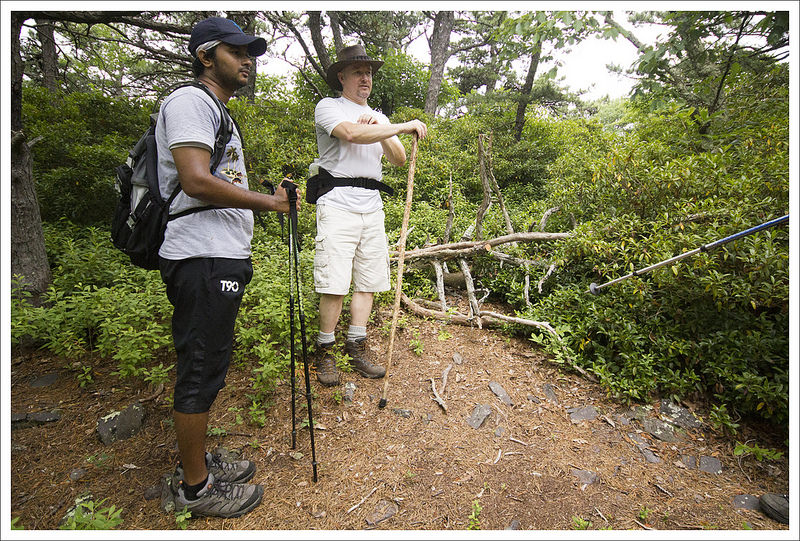
Like most hikers in Virginia, Adam and I are fans of Hiking Upward. It’s one of our primary resources for route information. We’ve been in touch with Bryce and Tony (the creators of HU) off and on the past few years. We had casually tossed around the idea of meeting up for a hike or backpacking trip, but our schedules never seemed to work out. Finally, in June, we found a date that suited everyone and made plans to meet up for a hike of House Mountain. The HU guys were working on updating information for the re-routed trail up Little House Mountain and we were hiking the area for the first time.
The morning started off gloomy and gray. I was a bit worried about missing out on views, but we got in the car and hoped for clearing skies. Everyone got to the trailhead around 8:30 a.m. We made our formal introductions and started the hike right away. Our hiking party was made up of Adam and me, Tony and Bryce (HU team), and two of Bryce’s friends from work – Wayne and Bharath. It was a great group to hike with and we all fell into easy conversation on the hike up.
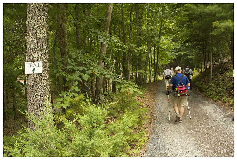
The first couple miles of this route follow the Saddle Ridge Trail. This portion of the hike starts off as a gravel road and passes a number of private residences. After the first half mile, the route becomes more trail-ish and passes through shady woods. There is one decent view of rolling hills and field on the right side of the trail.
At about two miles in, you reach the saddle between the Big House and Little House summits. The saddle was historically a homestead and a fruit orchard before being turned over to public use. There is still plenty of open pasture space for tent camping in the saddle. Take a few minutes to read the informational signs about the area while you’re at the saddle. They provide information about the area’s history and the conservation efforts that made these trails possible.


When we visited, we decided to hike Little House first. The trail to the summit is a recent re-route. The old trail was extremely steep, climbing straight up the mountainside without the amelioration of switchbacks. The new trail is still quite steep, but the switchbacks definitely ease the climbing. The trail was just blazed in spring of 2014, so if you hike anytime soon you’ll see plenty of fresh blue blazes marking the way.
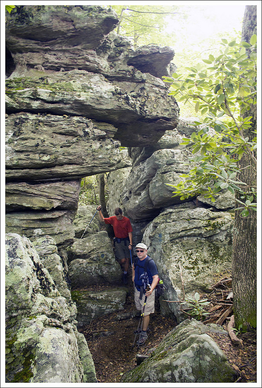
We caught some nice views through the trees on the way up before finally gaining the ridge. The ridge made for more moderate walking and included lots of interesting rock formations. There were several small campsites along the ridge walk, too.
Eventually, we reached the end of the trail and a beautiful viewpoint. It was still pretty overcast, but the low clouds had lifted enough to give us a view of the valley below and surrounding mountains. We took time for a snack and a few photos before making our way back down to the saddle. On the return trip, Tony and Bharath decided to take the old trail back down. They beat us back to the saddle by a few minutes.
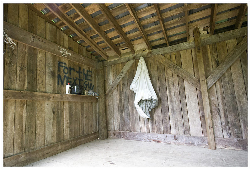
With everyone regrouped, we headed up the trail to the Big House summit. Within the first couple tenths of a mile, we passed the House Mountain backcountry shelter. It was a nice spot with a new privy and a side trail leading to a spring. We found the shelter stocked with lighter fluid, plastic silverware and other often-forgotten necessities. This hike would make a great beginner backpacking trip! You’d have a couple miles of hiking with a pack. But then you could set up camp and visit the two summits pack-free.
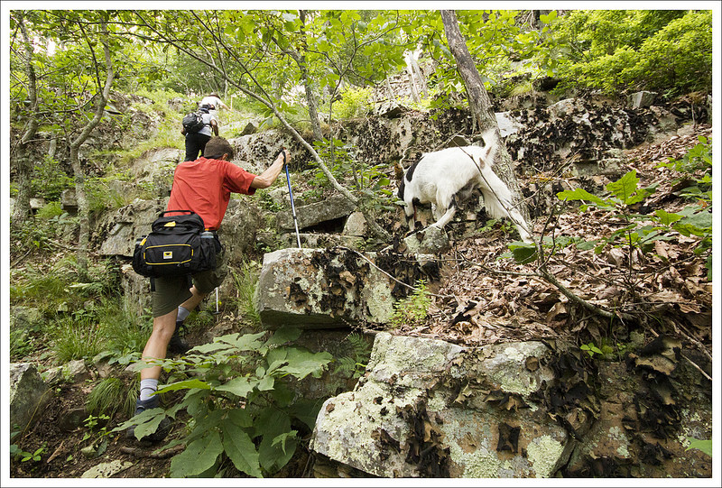
Most of the climb to Big House is along a rugged ATV trail. It’s straight up the mountainside until you reach one large switchback. At the switchback, look carefully for a very rocky, less-worn footpath departing the trail. Depending on the vegetation, this might be an easy spot to miss. If you take the switchback and continue the trail in that direction, you’ll just have a longer walk in the woods and no views.


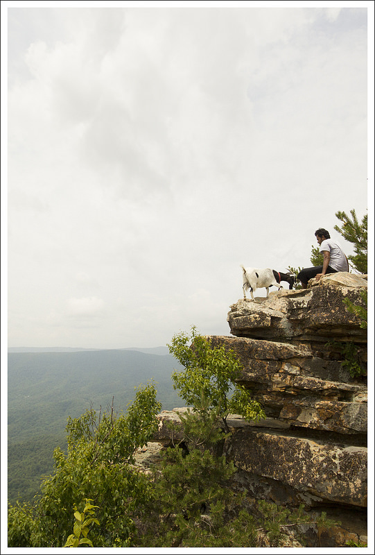
We started scrambling up the rocks when all of a sudden a black and white animal wearing a red collar bounded out of the woods. At first, I thought it was another random hunting hound that was lost in the mountains. But no… it was a GOAT! She hiked with us the rest of the way to the viewpoint.
At the summit, she followed us around – begging for food and vigorously licking the salty sweat off our arms and legs. It was a hoot and we really enjoyed such a friendly and novel companion on the trail. We ate more snacks, took more photos and spent time hanging out with our new goat buddy.
On the hike down, the goat left us shortly after the switchback. She gave us several loud farewell bleats before she bounded back into the woods. The return hike to our car was all downhill, passing the saddle one last time before retracing our steps on the Saddle Ridge Trail. Near the end of the hike, we had the privilege of meeting Brian. He lives in one of the houses along the trail and is one of the primary people who works on building/maintaining the trails on these mountains. If you see him, be sure to say thanks!
At our cars, we decided to head into downtown Lexington for some post-hike food and beers! As Bryce put it ‘Every good hike should end in a pub!’ We had a good meal and more fun conversation at ‘The Palms’. It was mid-afternoon and not very crowded when we visited – probably a good thing to not subject too many fellow diners to the smell of dirty hikers. 🙂 After lunch, we made our farewells and parted ways. We had a great day and can’t wait to hit the trail with these guys again.
Adam Says…
It was great to finally meet up with Hiking Upward. We do most of our hiking with just the two of us, so there is always a little anxiety about hiking with new people. Because of all the miles they have covered, I wondered if we would be able to keep up or were going to get left in the dust of their hiking boots. Along with our pace, I also wondered what we’d talk about. However, within a few minutes, I knew we were quite the kindred spirits. We talked about many things from hiking experiences to favorite microbrews. As we were sharing some of our favorite trails, we were bringing up names of trails as if we were consulting maps. I guess when we all write these hiking entries, that knowledge sticks with us. I know this was the first of many adventures we will share together.
We started off from the parking lot (pay attention to the sign to know where to park and respect the boundaries). We made our way up the road and at .3 miles, you reach a gate that begins the official trailhead. Past the gate, you start a gradual ascent up a fire road, passing by a residence to the left. At 2.25 miles, you reach the saddle between Big and Little House Mountain and the junction between the two trails.
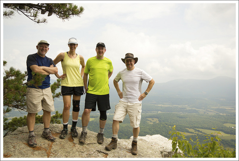


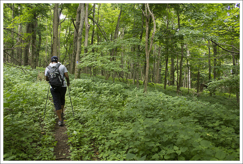
We started off by hitting Little House Mountain first, taking a right at the information signs and following the blue-blazed trail. The trail starts off relatively flat, but as you round the mountain the trail is very narrow and requires you to be mindful of where you step. At 2.5 miles, the trail then begins to climb up the ridge very steeply and you begin a series of switchbacks until you gain the ridge at 3.1 miles. The trail at this point goes through a thick area of rhododendron and remains slightly flat or downhill until you reach the viewpoint. Along the way, you pass through some areas of larger rocks. At 3.6 miles, the trail opened up to breathtaking views. We paused here for a while to eat a snack and take some photos. There are a few different places to get views from the rocks nearby.
We made our way back to the junction and saddle area, which we reached at 5.0 miles. Now, it was time to take on Big House Mountain. We took the opposite trail at the junction (as you were originally climbing up the trail, it is the trail to the left), making our way through some grassy areas before the trail opened up. Within a short distance, we passed a nice overnight shelter to the right. This shelter had it all – there was a sleeping bag someone left behind and even some cans of Yuengling for someone else to enjoy (if warm beer is your thing). There was a privy building a short distance away. We noticed another blue-blazed trail, which we were told later (by Brian, the trail maintainer) leads to a water source.


After we passed the shelter, the trail opened up to a larger fire road again which kept up a steady, tough climb gaining 400 feet in .4 miles. The trail came to a junction with a switchback trail to the right that leads to the true summit of Big House Mountain, but the views are gained by staying straight on the trail. The trail becomes very rocky at this point and we were soon joined by our goat friend. Her nimbleness on the rocks amazed us and she led us to the rocky Goat Point viewpoint at 5.9 miles. There was an upper perch and a lower perch for taking in some of the gorgeous views. As I was heading to the lower outcropping, I spotted a geocache behind one of the rocks. As I was signing the log, the goat jumped down from the high perch, scaring me and almost making me fall down the mountainside. Be careful out there, especially when there are salt-craving goats waiting to pounce.
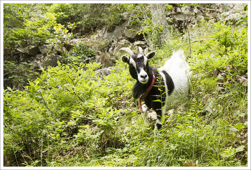

We headed back after taking in the views for a while (and being thoroughly licked by the goat). I will say that I think I was the favorite of the goat. This wasn’t the first time I had been amply licked by a goat while hiking – the other time was when we hiked the Massanutten Ridge trail. Maybe the salt from my sweat tasted the best or I was the most agreeable to being licked – I’m not sure. But, as we headed back down the goat followed us until we reached the rocky junction with the switchback to the summit. She stared at us from the top as if to beg us to come back to his place for more licking. We said our goodbyes to the goat and then made our way back. We reached the saddle junction again at 6.6 miles and made it back to our car at 8.75 miles.


If you are interested in geocaching, there are 17 different geocaches to find on the Little House Mountain and Big House Mountain trails. I won’t list them all here, but here are the two at the summits:
After we arrived back at our vehicles, we decided to hit The Palms in Lexington for some great food and a few beers. We had such a great day with our new friends! I can’t believe that we had not heard much about this hike before. This is a true gem of a hike with so many panoramic views!
Trail Notes
- Distance – 8.75 miles
MapMyHike Stats* - Elevation Change – 2850 ft.
- Difficulty – 4.5. There is some pretty serious climbing on this hike. Not many hikes of this length in Virginia have quite so much elevation gain.
- Trail Conditions – 4. The trail was in great shape and the hard work put into maintaining this trail is evident. The newer trail to the summit of Little House Mountain is narrow and steep with some loose sections. We recommend a hiking stick or trekking poles to help keep yourself upright!
- Views – 4.5. Gorgeous! I’d love to visit on a crystal clear fall day sometime!
- Streams/Waterfalls – 0. None – but there is a small piped spring near the camping shelter.
- Wildlife – 3. Any trail that has a wild(ish) goat gets a few wildlife bonus points!
- Ease to Navigate – 4. The trails in this area are very well-marked. The one tricky spot might be finding the viewpoint on Big House Mountain. If you miss the rocky path departing the trail at the hairpin turn, you might miss the views altogether.
- Solitude –3. We saw a fair number of hiking groups along the trail, but had both overlooks to ourselves.
Download a Trail Map (PDF)
Directions to trailhead: From I-81, take the I-64 exit 191 toward Lexington/Charleston. Follow I-64 for six miles to exit 50 (US 60 East). Follow US 60 East for 2.2 miles, turn right on Route 639. Go .8 miles and bear left onto Route 638. Follow 638 for 1.1 miles. Turn right on Route 641, go 1.1 miles. Turn right onto Route 643. Parking is on the left side of the road in .3 miles. Make sure you follow the parking signs on private property.
* MapMyHike is not necessarily accurate, as the GPS signal fades in and out – but it still provides some fun and interesting information.

One thought on “House Mountain”