This 7.3 mile loop has a bit of everything – views, waterfalls, history! The route takes you over Hazeltop Mountain, along several streams and past President Hoover’s Rapidan Camp.
Camp Hoover sits where the Laurel Prong and Mill Prong spill together, forming the Rapidan River. Below: Trillium was blooming everywhere when we hiked; The route had many stream crossings; Adam enjoys the view from Hazeltop.
Christine Says…
We love hiking in this part of Shenandoah! It’s the area we typically choose when we have out-of-town friends who want to visit Shenandoah National Park. It’s also a likely choice when we’re hitting the trail with hiking newbies. Why? Well… we think it’s pretty much perfect. The climbing isn’t difficult, so it helps convince non-hikers that hiking isn’t just torturous uphill climbing. This area is great for spotting wildlife. (In his portion of the post, Adam will tell you more about the exciting wildlife experience he shared with his office.) It’s also scenic, with lovely streams and a waterfall along the route. There is even a significant piece of American history sitting in the middle of the forest – the Rapidan Camp, which served as Herbert Hoover’s presidential retreat.
Our normal route in the area is a relatively easy 4 mile out-and-back to ‘Camp Hoover’. For this post, we decided to go the long way and make a 7.3 mile loop incorporating the Appalachian Trail, the Laurel Prong Trail and the Mill Prong Trail. This longer route added a nice view, many stream crossings and a bit more elevation gain.
Lots of trees were blooming in the park! Below: Adam walks along the Appalachian Trail. Adam was like a wind sock on Hazeltop.
We parked at Milam Gap. The hike started across Skyline Drive on the AT, headed southbound. Almost immediately, the trail began a long, gentle ascent to the summit of Hazeltop Mountain. The AT is so well-worn into the mountain that the path looked like a ribbon of dirt through the bright green of spring grass. On this particular May morning, the trail was abundantly lined with my favorite wildflower – Trillium. They were everywhere with big showy flowers in pink and white. We also saw (and heard) many birds. The prettiest songs came from the eastern towhees. This type of towhee has striking orange, white and black markings, which makes them easy to spot.
After almost two miles of climbing, we reached the high point of the hike on Hazeltop Mountain. There was one nice place to take in the view. It was really windy on the rocky outcropping, but I enjoyed looking out over the spring-green valley. From the viewpoint, we hiked downhill for almost half a mile to reach the junction of the AT and the Laurel Prong Trail.
There are obstructed views from the Laurel Prong Trail. Below: Eastern Towhee; Huge boulders and rocks along the Laurel Prong Trail; A neat tree near the junction of the Cat Knob trail.
The Laurel Prong trail descends all the way to Camp Hoover. Along the way, you’ll get some obstructed views from the trail, especially when trees are without their leaves. There are lots of rocks and boulders lining the path, especially right at the beginning. The lower parts of the Laurel Prong trail pass through a mix of open forest and mountain laurel thickets. As you approach the low point of the hike, you should begin to hear the sounds of water. Most of the time, streams along this trail will be shallow to non-existent. When we hiked, it was after several days of heavy rain. Single-step crossings became multi-rock hops and in many places the trail was under several inches of rain. It was fun to cross so much water!
At around the 5.25 mile mark, we reached Camp Hoover. It was a great spot to eat lunch, soak in the sunshine and enjoy the sound of rushing water. The camp is built at the headwaters of the Rapidan River, making it an ideal fishing spot. Most of the buildings that made up the camp have been lost to the ravages of time, but several cabins, including the president’s personal residence, have been renovated and preserved and are now open to the public (check park schedules for tour opportunities!).
While Adam napped in the sun, I went and did battle with my new carbon fiber tripod. It’s really light and stable, but it’s like an engineering puzzle to get it initially set up! I may have threatened to throw the tripod into the river. I guess I should look at this hike as the tripod’s dress rehearsal. It can prove its true worth on another hike. Besides, it really wasn’t a good day for taking photos of moving water (too sunny), but I think I was able to capture the impressive flow we witnessed on this day. I’ve never seen the streams around Camp Hoover flowing so powerfully! There were rapids and small waterfalls in places I’ve never seen them before. It was beautiful!
The Laurel Prong joins with the Mill Prong to form the Rapidan River just a few hundred feet from this spot. Below: Adam cross the stream again; The Brown House has a great back porch; Another streamside view of the Brown House.
After leaving Camp Hoover, we walked the trail along the Mill Prong. There is one spot where the trail crosses the stream (right below Big Rock Falls). We probably could have rock-hopped if we were careful, but both Adam and I decided to take off our boots and put on our Crocs to wade across the stream. The water came over my knees, which is really high for this spot.
After crossing, we took a few minutes to enjoy Big Rock Falls and then made our way back toward Milam Gap. For much of the way, the trail stayed close to the stream. We had several more stream crossings to complete, but none that required a shoe swap. The last couple miles of the hike went quickly, and we were back at the car by early afternoon.
We were surprised by how few people we ran into on the hike. I would have expected big crowds on a perfect, sunny Mother’s Day, but we really only saw a handful of people – a few backpackers making a short overnight of the loop and a pair of birders at the camp. I suppose we saw a few more people as we hiked back up the Mill Prong trail, but overall the crowds were light.
If I were to recommend a version of this hike – the 4 mile out and back or the 7.3 mile loop, I think I’d probably stick with the shorter version. The longer version is nice, and great if you’re looking to pick up some mileage, but there’s really not a lot to see on the Laurel Prong and it can sometimes be really muddy. The main reasons to hike in this area are Camp Hoover and beautiful stream scenery; and you get both of those on the shorter out-and-back.
Adam Says…
The hike down to the Rapidan Camp is always one of our favorites in Shenandoah National Park. We have taken several groups of people down to this area. When I talk to people about Shenandoah National Park, they have no idea that a Presidential retreat was once here and how this helped to establish a national park in Virginia. This route adds a view to the hike for an extra bonus.
Big Rock Falls was as big as we’ve ever seen it! Below: Adam crosses the stream right below Big Rock Falls; Lots of water in these little streams.
We’ve seen that on Hiking Upward and in our Hiking Shenandoah National Park Falcon Guide the hike was done in the reverse direction that we did the hike. But, our way has less of a continuous elevation climb and it puts Camp Hoover in the last third of the route (save the best for last!). We started off from the Milam Gap parking area and crossed Skyline Drive near the southern entrance to the lot to start on the Appalachian Trail. Heading southbound on the white-blazed AT, we quickly came across the junction with the Mill Prong Trail. This is your return route, so continue to go straight. The trail gradually climbs up a total of 450 feet. You reach a nice viewpoint to the right of the trail around 1.8 miles before you reach the Hazeltop summit in 1.9 miles.
The trail then begins to descend and at 2.6 miles, you reach the junction with the Laurel Prong Trail on the left. Take this blue-blazed trail which continues to descend. At the 3.6 mile, you will pass a junction with the Cat Knob Trail but stay on the Laurel Prong Trail. At 4.9 miles, you reach another junction with the Fork Mountain Trail, but again stay on the Laurel Prong Trail. The trail changes to yellow-blazed at this point, since it is now accessible to horses. At 5.3 miles, you will pass by a fire road on the left and then come up to a side trail for Five Tents. The Five Tents location was where some of the staff would stay at the Rapidan Camp, but there is no longer a building there. Christine took this route, but I stayed straight and we met up shortly at the Rapidan Camp, entering near the Prime Minister’s Cabin.
Upon leaving the Brown House at Rapidan Camp, we caught the trail heading past the Creel Cabin. Crossing the fire road, we picked up the yellow-blazed Mill Prong Trail which gradually ascends most of the way. At 5.5 miles, you will cross Mill Prong (which may require you to wade across the water after heavy rainfall) and reach Big Rock Falls on the other side. At 5.9 miles, you reach a junction with the Mill Prong Horse Trail. Continue straight instead of taking this trail, but the blazes change to blue as it is no longer a horse trail. The trail crosses Mill Prong again and then you will have a gradual climb back up. At 7.3 miles, you reach the Appalachian Trail junction again. Take a right and in a short distance you’ll reach the parking lot.
Pretty pink trillium Below: Wild geranium (I think?); Ragwort; Adam finishes out the loop.
Last year, I brought a few of my co-workers down to the Rapidan camp for a team-building retreat. I felt that if it was good enough for the President, it should be good enough for us. When we arrived, a volunteer who stayed at the Creel Cabin, gave us a tour of the Brown House, where President Hoover stayed. We learned a lot about Hoover, the problems he faced during his presidency, and his relationship to Franklin D. Roosevelt. After the tour, we did some team-building and communication exercises to learn more about how to work best with each other. While we were in the middle of making some breakthroughs, a small snake fell down off the roof just a few feet from where we were working. One of my co-workers, who is not a hiker by any definition, jumped out of her seat and was constantly looking around for other animals. After we made our way back up, we were talking along the way. I heard some people say, “Adam, look out”. I nearly walked right into a mama bear with three cubs. The family of bears quickly took off up the hill. I had told my co-workers that I’m usually pretty good at finding bears and we may see some. They were thrilled to see the cubs, as a few of them had never seen a bear cub before.
Along with the possibilities of seeing bears, you can usually find this trail to be an excellent trail for birding. The Laurel Prong and Mill Prong trails were filled with beautiful songs as we hiked along. A couple that was hiking near us also recognized the song of a blackburnian warbler.
If you’re up for a longer hike to the Rapidan Camp, I would suggest this route. The views from near Hazeltop summit were expansive, you get to see a nice waterfall, hear the songs of birds, and learn about the history of one of our Presidents and how it helped create a national park in Virginia. This hike does have it all!
Difficulty – 3. This hike is not steep or difficult, but some hiking novices might find the 7+ mile distance a little challenging.
Trail Conditions – 4. The trails were in great shape, despite being underwater in several place. We didn’t see any blowdowns or sloppy areas.
Waterfalls/streams – 4. Big Rock Falls, the Rapidan River, Mill Prong and Laurel Prong are all lovely and offer lots of water scenery along this hike!
Wildlife – 4. We didn’t see much on this particular day beyond birds, but we’ve seen lots of deer and bears on past trips.
Ease to Navigate – 4. Trail directions are clearly marked at junctions with cement markers.
Solitude – 2. This is a popular hike, both as a day trip and a short overnight loop.
Directions to trailhead:
The hike starts at mile marker 53 on Skyline Drive. Park in the Milam Gap lot, then cross the drive. The trail picks up on the other side of the crosswalk.
* MapMyHike is not necessarily accurate, as the GPS signal fades in and out – but it still provides some fun and interesting information.
This 13.2 mile circuit can be done as a day-hike, but we recommend extending the beauty and wildness into an overnight backpacking loop. Take your time, and you’ll be treated to panoramic views, lovely mountain streams, demanding climbs and peaceful campsites.
Christine takes in a a view of The Priest from Three Ridges mountain. Below: Welcome to the Three Ridges Wilderness; Over half of the circuit follows the Appalachian Trail; Nothing beats a campfire in the evening.
We had long been planning a three-day backpacking trip across Mt. Rogers, but as the day of the trip drew closer, we started seeing the term ‘Appalachian soaker’ thrown around in weather forecasts. We’re fine with passing showers and fleeting thunderstorms, but we didn’t want to get pinned down on Mt. Rogers on a wet and stormy night.
Fortunately, the weather in central Virginia was far more favorable, so we ditched our Mt. Rogers plan, and decided to hit another backpacking circuit on our list – Three Ridges. This route, which makes use of the Appalachian Trail and the Mau-Har Trail, is known as one of Virginia’s most rugged hikes. Everything we read about the circuit in advance of our trip emphasized the hike’s strenuous nature. With roughly 6,800 feet of elevation change, you’re almost never walking on flat trail. It’s a constant onslaught of heart-pounding climbs and knee-grinding descents. But along with the challenging terrain, you get spectacular views, beautiful streams and lovely campsites.
We started out early Saturday morning. The first stop was fuel… for ourselves. We had a huge breakfast at The Chuckwagon in Harrisonburg. If you have a chance, stop by and indulge in one of their homemade 4-inch biscuits (Adam’s favorite is ‘The Round-Up’) or a stack of their amazingly fluffy pancakes. (Sadly… Chuckwagon closed in January 2013) With full stomachs, we made our way to Reed’s Gap at mile marker 13.7 on the Blue Ridge Parkway.
When we got to the parking area, the lot was already jam-packed, mostly with heavy-duty construction vehicles left idle for the weekend. Just as we were about to give up and find a parking spot further down the parkway, one car pulled out and left an opening for us!
Adam makes the initial climb up Meadow Mountain. The climbing was occasionally rocky, but never terribly steep.
We started the Map My Hike app on Christine’s phone, hoisted our packs, and headed south along the Appalachian Trail. From the parking area, the trail hugs the edge of a meadow, which was full of blooming yellow ragweed and purple thistle. It was such perfect weather for backpacking – sunny skies, low humidity and a crisp breeze. The trail almost immediately began to climb uphill over Meadow Mountain. The climbing was steady, but never difficult, for about .8 of a mile.
At the top of the ridge, there was a small dry campsite with obstructed views. Department of the Interior boundary markers were all along the ridge. We spotted at least three or four right next to the trail. After walking briefly along level ridge, the trail descended to Maupin Field Shelter. The shelter site had tons of space for tents (many of the tent sites were flat, soft and grassy), a typical AT three-sided hut, a metal bear-hang post and a picnic table. The area also had an informational kiosk with trail notes and wilderness-usage policies. There was also a child’s orthodontic retainer tucked into a Ziploc and pinned to the board. We’re guessing there is now one retainer-less Boy Scout and a less than happy mother!
Christine climbs the stone steps up Bee Mountain.
After Maupin Field Shelter we began climbing again, over Bee Mountain. The climbing was slightly more strenuous, but definitely manageable. In several places, rock steps were set into the trail to make the climbing easier. Along the way, we started playing ‘Categories’. It’s pretty basic – each player designates a category, then players take turns naming items that fit within that category. For example, categories might include Movies Based on Comic Books or Items You Need on a Backpacking Trip. It’s pretty mindless, but it kills time. Whoever successfully names the last item for the given category wins the round. The best category of the day was Complaints Uttered When Hills Are Steep. We won’t share the specifics of our trail talk here, but it was pretty funny to reflect on this topic! Bee Mountain didn’t offer any views and was followed by a short descent before tackling the more serious climb up Three Ridges Mountain.
The climb up Three Ridges consisted of several steep pushes, with nice stops for views all along the way. The first view, Hanging Rock, was very impressive, so we decided to break for lunch and enjoy the amazing vista. As we ate our Panera bagels (Cherry-Vanilla with Justin’s Chocolate Hazelnut Butter for Christine and French Toast with Peanut Butter for Adam), we noticed two dogs fitted with radio collars – doubtlessly bear hunting dogs set loose in the woods for pre-season practice. Both dogs were female; both were emaciated and showed signs of over-breeding. We hate to cast aspersions or generalizations on any group of people, but we are not fans of hunters that use this type of technology to hunt bears. Both of the dogs were pretty persistent about trying to steal our food. The bolder dog, who was heavily perfumed by a skunk encounter, came within inches of snatching Christine’s bagel right out of her hand.
One of the bear hunting dogs we encountered seemed to be enjoying a view of the Priest from the Hanging Rock Overlook. Below: Adam climbing the first uphill section of Three Ridges Mountain; Southbounders (BeeSting, Fats and Happy) contemplate the Priest and their upcoming climb; The view from Hanging Rock.
While we sat at the overlook, we had a chance to chat with three Southbound AT hikers – Happy, Fats and BeeSting. All three had started in Pennsylvania in August and were making their way toward Georgia. Happy was already there when we arrived, so we got to talk with him for a good bit while he waited for his companions to show up. He was from Las Vegas and on his first long-distance hike. He told tales of his shoes breaking down on the Pennsylvania rocks, getting caught in a vicious cold-front driven storm on Bearfence Mountain, and his epic weight loss (40 pounds in less than a month!). He was a nice kid and we enjoyed talking to him and telling him about some of the things he has to look forward along the trail in Virginia – The Priest, Spy Rock, Cove Mountain, McAfee Knob the Grayson Highlands. He told us the friendliest place he’d stopped on the trail was the town of Waynesboro.
After a while, Fats and BeeSting came along. They were a young couple from Montgomery County, Pennsylvania. We didn’t talk to them as much, because we wanted to press on and make our way to camp by mid-afternoon. Happy left a few minutes ahead of us, and we were sure we wouldn’t see him again. Thru-hikers are known for keeping a blistering pace!
Upon leaving the vista, there was quite a bit more uphill climbing before we finally reached the true summit/highpoint of Three Ridges Mountain. At the highpoint, we ran into a group of three women out on the same circuit we were hiking. We chatted briefly about the great weather before leaving them to enjoy their lunch.
Christine enjoys the view on a perfect late-summer day. Below: The actual high point of Three Ridges is in the trees; Adam walking through ferns along the trail.
After the high point, the long, seemingly endless descent to Harper’s Creek began. It wasn’t always super-steep. Sometimes it almost leveled off. As we were walking along, we saw a bear dash off through the brush. We were both glad that the bear hunting dogs hadn’t pestered the bear into a tree. A few steps later, we heard an exuberant voice shouting into the wind – ‘Woooooo!’ ‘Yeaaaaaah’! ‘Echo Echo Echo’ and ‘I’m on TOP of the WORLD’. As the voice drew nearer, we guessed it was Happy having a ‘mountain moment’. Sure enough, he called to us through the trees so we could share the nice view spot he had found a little ways off the trail.
We left the spot before he did, knowing that there would be more views along the way. One unnamed view on the left side of the trail was especially beautiful. We stopped for photos and a pack-less rest. A bit further along, we saw a huge flat, upright rock that looked just like a tombstone. Immediately past that, we noticed a faint trail that climbed up steeply through the woods to a jumble of rock. We guessed correctly that we had found Chimney Rock. It was a great place to sit, and every bit as scenic as the very first overlook on Three Ridges. We enjoyed looking down into the valley, dotted with homes, streams and a large Christmas tree farm. The Priest, one of Virginia’s most beautiful and distinct mountains, loomed impressively across the way.
Adam enjoys one of the many spectacular views from Three Ridges Mountain. This particular stop came at a rocky outcropping known as Chimney Rock. Below: Views, views and more views!
After Chimney Rock, the last real vista was a wide flat shelf of rock overlooking the scene below. After that, the downhill got pretty bad. It was the bone-jarring, steep, type of downhill that makes your knees beg for mercy! We both slipped a couple times on the descent. It was probably all the fallen acorns – if your boot hits them just right, they sort of function like tiny roller-skate wheels. Adam managed to hyperextend his knee on one slip, and hiked in a significant amount of pain the rest of the day. Christine hit a loose flat rock and rode it like a surfboard until she finally landed hard, but unharmed, on her rear end.
Honestly, the uphill on this hike is moderately hard, but the downhill is brutal. Anyone in reasonable condition should be able to handle the physical demands of the ascents along the trail, but if you have bad knees, the descents are nothing short of punishing. We both tried to keep our packs on the light side for this trip. Christine’s pack was 22 pounds and Adam’s was 29… but that was before water. After a dry week, we weren’t sure if Harpers Creek would be flowing, so we both carried quite a bit of extra water – 3.5 liters for Christine and 4 for Adam. We knew there was a chance we wouldn’t need it, but when it comes to water it’s always better to be safe than sorry.
The climb down from the summit of Three Ridges was grueling and rocky! Below: The trail went over many large boulders; It passed thick stands of rhododendron and mountain laurel; We were thrilled when the Harpers Creek shelter site came into view.
After over two miles of switchbacks, dangerous acorns and tricky rocks, the colorful domes of tents came into sight. We had reached Harpers Creek Shelter – our stop for the evening. We found the shelter itself empty, but most of the tent sites adjacent to the shelter had already been claimed by a large group of Boy Scouts from Fluvanna County.
We found a mostly flat and smooth tent site across the creek, about 50 yards south of the shelter. We figured it was a perfect spot – we were close to the shelter and could use it for a ‘kitchen’. Also, the privy was on our side of the stream, but far enough from the tent that it wouldn’t be annoying when people went to use it.
For the most part, Harpers Creek wasn’t flowing. There were several shallow pools in the streambed, which gave us plenty of access to water, but also provided a perfect breeding ground for mosquitoes. Christine immediately noticed bites forming welts on her legs, so she quickly changed out of her shorts and into long pants. She tried to change behind a large boulder, but she’s pretty sure the Boy Scouts saw her in her underpants, but hey… modesty sort of goes out the window in the backcountry.
Within twenty minutes, the tent was up, the sleeping pads were inflated, and sleeping bags were in place. We set aside all the food, cooking implements, water filter and bear bags to take over to the picnic table at the shelter. The Harpers Creek shelter was small and kind of dingy. There was no shelter log. Actually, the only thing in the shelter was a sodden pair of ‘tighty-whiteys’.
Adam set about collecting water. We recently picked up a very handy collapsible bucket made by Sea to Summit. It folds down to about the size of a deck of cards and weighs just a few ounces. But, it allows us to collect up to nine liters of water at once. Typically, we pump water through our Katadyn straight into the bucket. Then we cover the bucket with a bandanna and usually have plenty for dinner, breakfast and bottle refills.
While Adam filtered water, Christine worked on collecting wood for a campfire. It was already starting to get chilly, so it was a perfect night for a fire. As is the case at most shelters, good firewood is hard to find. There is always plenty of tinder/kindling, but the larger, long-burning pieces of wood are at a premium. In the backcountry, we only use downed wood that we can break by hand.
Our camp on Harpers Creek. Below: Setting up our ‘kitchen’ at the Harpers Creek shelter; On the menu for dinner; Adam feeds the fire.
Christine made a teepee-style campfire with larger pieces of wood on the outside, and a tinder-packed center. All of the wood collected from the forest floor was cold and damp, so the fire had a hard time catching at first. A little squirt of alcohol-based hand sanitizer took care of that problem, and within a few minutes a small fire had sprung to life.
With the campfire going, water collected and the campsite set, it was time for dinner! We keep saying we’re going to prepare our own fancy homemade backpacking meals, but when the time comes we always seem to find ourselves reaching for Mountain House or Backpacker’s Pantry. It’s just easier, and for the most part, the packaged food is really tasty (notable exception – Natural High’s Banana Cream Pie – worst dessert EVER.) Our menu for the evening included Chili Mac with Beef as the entrée and Cheesecake for dessert. Christine brought several sticks of cheddar cheese to mix into the chili and single-serving plastic bottles of Merlot. It was quite the feast!
After dinner, we put up our bear hang. Oddly, this shelter did not have a metal post like most AT shelters in this part of Virginia. We had to find a tree with a free branch. After the food was secured, we settled into our camp chairs and enjoyed the fire. Some people we’ve met along the trail think the camp chairs are a waste of pack space, but they fold down to about the size of a water bottle and weigh just about a pound. We find them well worth the extra weight for the back-resting comfort they provide. We might not carry them on a long multi-day trip when every bit of pack space counts, but for a weekend trip, we like having creature comforts.
Entertainment unfolds by the campfire. Below: Our tent at night.
As we sat by the fire, we watched a little piece of comedy unfold on the other side of the stream. A couple of the older Scouts had been assigned the task of hanging the group’s food. We watched as they missed getting the rock and rope over the tree branch, dozens and dozens of times. The boys took turns making fun of one another for their off aim. Eventually, they got the rope over a branch. They celebrated with a high-five and a ‘Woot!’. But, the branch snapped off the tree as soon as they tried to hoist the weight of many food bags. Eventually they went for help and settled on a less-than-perfect, but still functional tree. All in all, it took them over an hour to get their food hung.
Our campfire died around 9:00, so we headed back to the tent. Adam read by headlamp and Christine listened to a book on her iPod. For one of the first times ever, we both fell asleep quickly and slept soundly through the night. We were actually awoken by voices and headlamps at what seemed like the middle of the night. Christine rolled over and asked Adam ‘Is it around midnight and these kids are up late or is it morning already?’ It turned out that the Scouts were awake and cooking/packing up at 5:30 a.m. We lazed around in the tent for another hour until the sun came up.
The Scouts actually hiked out around 7:00, just as we were getting breakfast together. Usually, we’re the early risers and the first out of camp! We made maple-brown sugar oatmeal with freeze-dried bananas and coffee and hot chocolate for breakfast. We both ate two packs, knowing that we had a tough day of hiking on the Mau-Har Trail.
After a good night of sleep, Christine is ready to tackle day two! Below: Adam changes out of his Crocs and back into boots; The Appalachian Trail departing Harpers Creek.
After breakfast, we broke down camp. Adam’s hyperextended knee was still pretty sore, so Christine stowed some of his gear in her pack to make his load a little lighter. While she was transferring gear, she noticed that a mouse had chewed through the little mesh compartment on the hipbelt of Adam’s pack! The only thing in the compartment was a set of car keys, so we’re really not sure why it was appealing to a mouse. It reminded Adam of one of his favorite books as a kid – The Mouse and the Motorcycle. He thought this mouse was trying to make a sequel with their car.
We left Harpers Creek around 8:00. On our way out, we passed four or five other groups that had been tenting near the shelter. All told, there were probably somewhere between 25 and 30 people camped along the creek that night. Quite a tent city!
After leaving the shelter site, we followed the Appalachian Trail for almost a mile, largely uphill, to its junction with the Mau-Har Trail. The odd trail name is a combination of Maupin and Harpers – the names of the two shelters the trail runs between. The Mau-Har was designed by a man named Angelo Filippi. One funny review we read of the hike evidently thinks ‘designed’ is too kind a word for the trail. The review states:
“We started from Reeds Gap and heading down the Mau-Har, cussing Angelo Philippe [sic] the whole dang way. I swear he unfolded a map, put it on the ground, pulled out a piece of string, dropped the string onto the map and said “There! That is where the trail should go!” What a jerk!”
The start of the Mau-Har Trail. Below: The Mau-Har trail starts innocently enough; Then it starts to climb more steeply downhill; And then it gets even steeper than it already was!
To be fair, the trail was clearly designed to follow scenic Campbell Creek as closely as possible and following a creek that goes tumbling through a deep gorge is going to require some rugged climbing. The Mau-Har trail descended very steeply to the creek. Adam grimaced in pain from his knee injury on every downhill step. The weight of his pack, combined with the steep trail was almost more than he could bear. This was some of the gnarliest downhill we’ve ever done.
Eventually, we got to the spur trail that leads to a series of small waterfalls. Adam decided to stay put and rest his knee while Christine explored the falls. She took off with the camera, hoping to get a few documentary shots for the blog. A few minutes later, Adam decided to follow. He had heard there was a geocache hidden by the falls (known as “firedogs fishbowl”), but he had forgotten to input coordinates into his GPS. He looked for it, but without coordinates it was pretty close to impossible to find. The waterfalls were all very small due to low water flow. In spring, with snowmelt and heavier rain, the creek is probably spectacular!
Water volume in Campbell Creek was fairly low. Below: The section of the Mau-Har that follows Campbell Creek is very steep; Some sections require you to pull yourself over the rocks; Christine is happy for a more moderate grade.
From the waterfall spur trail to the Maupin Field shelter, the Mau-Har climbs very steeply uphill. At first, the trail is very rocky as it passes through the canyon. You wind your way between and over boulders. Sometimes you have to stow your trekking poles in one hand to pull yourself up over a big step. It reminded us very much of hiking the gorge at Little Devils Stairs. The terrain was very similar. After leaving the canyon, the trail becomes less rocky, but no less steep. A series of sweeping switchbacks carry you relentlessly uphill. Eventually the grade becomes more moderate in the last half mile before you arrive at the Maupin Field shelter.
Near the end of the climb, Adam announced that he was going to stop at the shelter and ‘eat every single bit of anything edible left in his snack bag’. Two packs of oatmeal, bananas and hot chocolate burn off pretty fast when the climbing is tough! He proceeded to eat a Luna Bar, ShotBlox, a bag of cashews and a bunch of mini candy bars. He reined himself in and skipped eating a dry packet of cocoa mix.
At Maupin Field, we read the shelter log. Entries talked about the skunky, food-nabbing bear dogs (someone had named them Bagels and Muffins). A southbounder left a warning to northbounders about 20-30 miles of dry hiking. Someone even left a really nice pair of ladies LaSportiva for someone to claim.
Adam relaxes at the Maupin Field Shelter. Below: One of the stream crossings near Maupin Field Shelter; Adam checks out the shelter log; The Mau-Har’s end point at the shelter.
The last 1.6 miles retraced our route from the morning before. We had a gradual climb up and over Meadow Mountain and then back to our car at Reeds Gap. We drove back toward home along the Blue Ridge Parkway, stopping at Humpback Rocks to wash our hands with soap and running water. Our last stop was the Sonic in Waynesboro for more ‘refueling’. We definitely earned some tater tots and CreamSlushes!
Three Ridges turned out to be a great alternative to our planned Mt. Rogers trip! While the terrain was challenging, we think most people accustomed to backpacking/hiking would be up for the challenge and would enjoy the beautiful and wild scenery offered by this loop.
The one issue we would like to bring up is a discrepancy about the length of this hike. Most sources list the loop at 14.4 miles. Based on our information (maps, GPS, trailer marker posts), here is how we would break down the segment distances on the trail.
0.0 miles – Start from parking lot on Reeds Gap, heading south on the Appalachian Trail and begin your ascent. .8 miles – The trail reaches the first ridge and shortly begins to descend through some switchbacks 1.6 miles – Reach the junction with the Fire Road (which heads to Love Gap). Take a left to stay on the Appalachian Trail and pass a few side trails that lead to campsites at the Maupin Field Shelter. The trail begins to climb again. 2.0 miles – Reach the summit of Bee Mountain 3.7 miles – Reach some great views from Hanging Rock. Continue to climb further up through the woods. 4.2 miles – Reach the summit of Three Ridges 5.8 miles – Great viewpoint of the eastern ridge 5.9 miles – Reach the tombstone and take an immediate right up the path to reach Chimney Rock and the best views on the trail. Rejoin the trail and descend steeply. 7.5 miles – Arrive at Harpers Creek Shelter across the creek and your stay for the night. The next morning, cross back over the creek and continue on the Appalachian Trail. 7.6 miles – Cross Harpers Creek and the trail begins to ascend very steeply. 8.5 miles – Reach the junction with the blue-blazed Mau-Har trail. Turn right and follow the trail that parallels Campbell Creek. 10.0 miles – Reach a sign designating a short yellow-blazed trail to a few waterfalls. The waterfalls are only a few hundred feet off the Mau-Har trail. Retrace your steps and continue on the Mau-Har trail. 11.5 miles – Reach the Maupin Field Shelter. Continue straight past the shelter to rejoin the Appalachian Trail. 11.6 miles – Take a left on the Appalachian Trail to retrace your steps back to your vehicle. 13.2 miles – Return to the Reeds Gap parking lot.
Returning to Reeds Gap. At this point, Adam said he was 90% sure he was going to survive the trip. Below: Christine had a great time!
Trail Notes
Distance – 13.2 miles (Check out the stats from MapMyHike [Day One] [Day Two])*
Elevation Change – About 3900 feet
Difficulty – 5. This hike is no joke. The downhill areas are steepest on the Appalachian Trail coming down from Chimney Rock and the uphill on the Mau-Har trail is equally brutal.
Trail Conditions – 2.5. The trail starts off quite nicely, but once you reach Three Ridges, expect a rocky slide downhill and loose footing uphill for much of the hike. The Mau-Har Trail was pretty overgrown in places.
Views– 5. Absolutely amazing. Chimney Rock and Hanging Rock provide some of the nicest views.
Streams/Waterfalls – 3. You’ll be near a stream most of the second day and there are a few small waterfalls. The water wasn’t flowing too strongly though.
Wildlife –3. We did see a bear. Oh yeah, and the mouse ate through part of Adam’s backpack, so there is some wildlife out there.
Ease to Navigate – 4. The trails were fairly well marked and signs were at the junctions.
Solitude – 2. This is a tough hike, but it is popular for backpackers, trail runners, and day visitors to the shelters.
Directions to trailhead: On Blue Ridge Parkway, south of Humpback Rocks. Park at mile marker 13.7 at Reeds Gap in the large lot. Head south on the Appalachian Trail, marked with white blazes on a tree near the left of the open field.
This 5.9 mile loop takes you over Cadillac and Dorr mountains – two of Acadia’s most prominent peaks. There is some very steep climbing along exposed granite on this hike, but the views are truly spectacular!
Cairns mark the trail along the ridgeline leading to the summit of Dorr. Cadillac Mountain is visible across the gorge. Below: Stone stairs on the North Ridge Trail; Adam climbs across bare granite, Trail names are marked at junctions; The trail was more forested after leaving Kebo Mountain.
Christine Says…
Tuesday morning started clear and sunny, so we decided to get an early start and tackle a loop hike that would take us across the summits of Cadillac, Dorr and Kebo mountains. After bagels, muffins, fruit and coffee (hooray for free hotel breakfasts!), we made the short drive from downtown Bar Harbor to the Cadillac North Ridge trailhead, which is located shortly after the Park Loop Road becomes one-way.
We’ve climbed the North Ridge Trail three or four times before, but this is the first time we combined it with other trails to create a loop. The North Ridge Trail is significantly shorter than the South Ridge, but still offers beautiful views of the ocean and offshore islands. When we arrived, we were able to get a parking spot at an overlook right across from the trailhead. Unless you get an early start, you’ll definitely want to use the Island Explorer bus to access this hike. It’s a popular route, and the overlook can only accommodate several cars.
Porcupine Islands are visible along the North Ridge Trail. Below: Adam at the trailhead at the beginning of our hike; Christine hikes across open granite; Cairns and the Porcupine Islands.
As we started hiking uphill, we passed a family of four that had hiked up in the dark to arrive at the summit in time for sunrise. They looked exhausted but told us it was well worth the early start. After that group, we really didn’t see anyone else until we arrived on the summit. Even though it was early, the day was already really hot and humid. Not even a hint of breeze was blowing. I’m not used to sweltering in Maine (even in the summer), but I was so hot! My head was pouring sweat which soon washed all the ‘waterproof sport’ sunscreen off my face. Sometimes sunscreen seems like a losing battle!
Occasionally, the trail would duck into a small copse of pine trees. Momentarily, the heat would abate and I would feel comfortable for a few minutes. But the shade never lasted, and I continued to march up the mountain, behind Adam. Finally, I had to stop and pull my shirt up and across my face to dry off the sweat. Adam looked back at me and I told him I was hotter than I’d ever been in my entire life. And honestly, that wasn’t much of an exaggeration!
Adam passes a precarious cairn as he nears the Cadillac Summit. Below: Lots of sweeping views and granite; The trail occasionally went into the shade; Big sky over Cadillac.
As we approached the summit, the trail followed closer to the auto road. We could see the roofs of passing cars and hear motorcycles rumbling nearby. Whenever the trail came close to the road, I noticed more trash littering the trail – bottle caps, candy wrappers, and so many cigarette butts. People driving up clearly throw stuff out their windows – how they can do that in Acadia is beyond me!
Soon, the parking lot at the summit of Cadillac came into view. It was still fairly early, so the summit wasn’t terribly crowded – one bus and a few dozen cars. We got cold drinks at the summit shop. Adam surprised me with a bandanna with a map of Mount Desert Island on it. He thought I could use it to mop sweat! I tied it onto the shoulder strap of my pack, and we headed off to explore the network of paved pathways around the summit.
We took a few photos and then worked on finding the Gorge Path. Basically, we just had to find cairns heading down Cadillac and in the general direction of Dorr Mountain. There were no signs or markers telling us we were going the right direction (all blazes in Acadia are blue and trail names are only identified at junctions). Pretty soon, we were all but certain that we were going the right way. The steep, boulder-strewn face of the mountain matched the description we had read of the Gorge Path. I put my trekking poles away, so I could have both hands free to climb. I also stowed my dSLR and got my inexpensive point-and-shoot out to document the climb down.
Christine enjoys the view from Cadillac Mountain. Below: Adam at the summit building; Crowds on the summit; Adam begins the climb down the Gorge Path.
The climb down went pretty quickly. Though, all the while we were looking at the face of Dorr. I asked Adam if we were going to be climbing up that cliff face. He said ‘I don’t see how the trail would go… but maybe?’. Around that time, we spotted two colorful specks making their way down the mountain – other hikers. They confirmed the trajectory of our upcoming climb.
At the junction in the saddle between Dorr and Cadillac, we took a break. I actually changed out of my heavy Oboz hiking boots and back into my Montrail trail runners. Initially, I thought the Oboz would be better on this ankle-turning terrain, but really they just made me feel clumsy and heavy-footed. I think I might have taken my final step (pun intended) in my transition to trail runners.
The climb up Dorr ended up being much easier than I expected. From the shoulder of Cadillac, it looked steep and slick and scary. But once we were actually there, the climbing was really fun! I enjoyed looked back at the tiny, ant-like people atop the Cadillac summit. Once we finished the initial climb up the face of Dorr, the walking was fairly gradual and moderate along a ridgeline. The summit was marked in traditional Acadia-fashion – with a large pile of stone with an elevation/summit marker in the middle. There were a few groups of hikers atop the summit of Dorr, but nowhere near the crowds on Cadillac.
Adam takes in the view from the Gorge Path.
There were several routes down Dorr, so Adam consulted out map and hiking guide to make sure we found the right one. On most Acadia hikes, you get views in nearly every direction, so we stopped frequently to admire the beauty around us. The climb down Dorr turned out to be tough – steep and knee-grinding. Granite is always jarring and unforgiving on your joints. I could see Adam starting to grimace in pain along the descent.
Once we were back in the woods and the views were gone, we still had a couple more miles to go, so we focused on covering the terrain as quickly as safety would allow. Most of the return arm of the loop was downhill, with one short uphill climb over the summit of Kebo mountain. Kebo is short and tree-covered, and offers no open views. After the summit of Kebo, the remainder of the hike passed through forest before eventually coming back out on the Park Loop Road. From the end of the trail, we still had about a mile of road walking to get back to our car.
The road was really crowded and the shoulder was narrow. I practically jogged to get the road-walking portion of the hike completed as quickly as possible. I got back to the car a little before Adam. I found a ranger writing parking tickets for all the cars that had overflowed the North Ridge parking area. There were probably about a dozen cars people had just left sitting in the middle of the road. Someone had parked on either side of our Subaru, allowing just inches in front and behind. It took me about ten minutes to rock the car out of the spot. By the time I got the car out, Adam was making the final uphill push along the road. I picked him up and we headed back into town to get a big lunch with my parents.
The Cadillac-Dorr loop was an ideal way to bag these two Acadia summits in a single hike! I think I still like the South Ridge Trail up Cadillac a little prettier, but this was a fantastic hike, too.
Adam Says…
When we were deciding which hikes that we would like to have accomplished for the week, we both knew we wanted to hike up Cadillac Mountain. On our last trip, we hiked up the south ridge of Cadillac Mountain. But our first time hiking up Cadillac Mountain was taking this route up the north ridge and we were excited to cover it on the blog. Christine has been mentioning the last few trips to Acadia that she wanted to hike up Dorr Mountain. My memory of hiking up Dorr Mountain (via the East Face Trail) included visions of hiking up seemingly endless rock stairs and I was not excited to do this again. So, I consulted my map and came up with a way that we could combine the two and also bag another peak, Kebo Mountain. The great thing about Acadia National Park is that so many of the trails intersect, so you can be quite creative with how you approach different hikes.
Adam climbs the steep, rocky face of Dorr Mountain. Below: Adam looks back at Cadillac; People look like tiny ants on Cadillac; Walking the ridge toward the summit of Dorr.
We started our hike from the Park Loop Road at the trail marker for the Cadillac North Ridge Trail. Climbing up a few quick steps, we started to ascend the granite path that makes up the entire park. In a short distance, the blue-blazed trail then turns right and you entire a wooded area of evergreens and birches. As you approach .6 miles, the trail begins to draw close to the Cadillac Summit Road and you may hear cars and motorcycles nearby but the road is not visible for much of the hike. The trail continues through the forested area, but occasionally will open up to some views. At 1.1 miles, you reach a section of over 100 steps built into the trail. Once you feel tired of the steps, the trail comes above the treeline and begins to open up to gorgeous views behind you. The trail becomes a little trickier at this point as you have to focus more on following the blue blazes marked on the rock or cairns that lead you along the trail. A few times, you will come closer to the road and may even see some cars parked at pullouts enjoying the views. Keep following the trail and you will reach the top of Cadillac Mountain (at a parking lot) at 2.2 miles.
Many of the summits of the mountains are marked by tall cairns and signs marking the summit. For Cadillac Mountain, the 1,532 foot summit is marked simply with a USGS summit marker, which is located behind the gift shop at the top. On a clear day, you will likely see a full parking lot and a ton of people climbing around the rocks of Cadillac Mountain taking photos. But, instead of driving up to the top, you have earned it by hiking up.
At the top of Cadillac Mountain, there is a .5 mile Cadillac Summit Trail which is a loop around the top of the mountain giving you great views along the way. We took this trail around for .3 miles and on the Northeast side you will begin to see some cairns that marks the Gorge Path. Follow this trail down the mountain which starts to quickly go steeply down the side of Cadillac Mountain. I would only recommend this trail if you feel like you have good balance and knees as you are climbing down a steep rocky path, often requiring you to crab crawl down the trail on all fours in some spots. It is called the Gorge Path for a definite reason and you will soon see that this path cuts sharply between Cadillac and Dorr Mountains. I kept trying to look ahead to see if the path leveled off to join Dorr Mountain, but you do have to go to the bottom of the gorge before you climb up on the other side. At 2.9 miles, just .4 miles and 500 feet down from the summit of Cadillac Mountain, you reach the bottom of the gorge and will see a sign marking the intersection of several trails. We went straight across to begin climbing up to the summit of Dorr Mountain. This part of the trail was not as bad as it appeared as we were descending Cadillac Mountain, but it does require some rock scrambling to make your way up. At 3.1 miles, we were finished with the scrambling and reached another intersection sign post. Heading to the right following the Dorr South Ridge Trail, we hiked another .1 mile, following cairns along the way, until we reached the summit post of Dorr Mountain at 1,270 feet.
Once you are finished enjoying the summit, we retraced our steps back to the intersection sign at the top of Dorr to follow the Dorr North Ridge Trail at 3.3 miles. This trail is extremely steep downhill, descending 900 feet over the next mile, but we were glad we were hiking down instead of up even though it is hard on the knees. At 4.2 miles, you come to an intersection with the Hemlock Trail, but stay straight. The trail then begins to go up and down as you crest some small hills until you make another climb up to Kebo Mountain. At 4.8 miles, you reach the summit also marked by a summit post, but there are not great views from here. Once we reached the summit, it was another downhill hike until we reached the Park Loop Road at 5.1 miles. Take a left here, ascending slightly up the road until you return to your vehicle at 5.9 miles.
The summit of Dorr Mountain. Below: Christine on the summit; Island view from the Dorr summit, Trail markers upon departing Dorr.
While I do think you earn some respect by hiking up Cadillac Mountain, I’m always impressed with the people that bike up the Cadillac Summit Road. While I was drinking a Gatorade while resting outside the gift shop, I struck up a conversation with a man in his upper 50s that had just biked up. When I asked him how long of a ride it was, he laughed and said that he just knew that it was 1150 feet up. As I researched later, it looks to be a 3.5 mile ride, but that is some decent elevation to gain in that distance on bike. I’m sure the ride down is more fun, but this could be tough on your brakes.
I did cover some of the interesting history behind Cadillac Mountain on our South Ridge post, so I thought it would be interesting to talk about the history behind the naming of Dorr Mountain. George Dorr was the man that is often credited as being the father of Acadia National Park. Hailing from Boston originally, he first came to visit Mount Desert Island in 1868. He decided to make his permanent home here on the island. He worked on convincing others that protecting this area was important and acquired much of the land through the Hancock County Trustees by purchasing it or receiving it in donations. While the trustees were being threatened with having their ownership revoked, Dorr worked with lobbying the government to help protect the land. In 1916, President Woodrow Wilson created the 6,600 acre Sieur De Monts National Monument. In 1919, the area expanded to become Lafayette National Park, later changed to Acadia National Park in 1929. George Dorr became the first director of the National Monument and the director of Acadia National Park. He swam daily from his home on the coast, even chipping through the ice in the winters. He suffered a heart attack after a morning swim in 1934 and was told he had six months to live. But, he survived for 10 more years before dying on 8/5/44. Dorr Mountain was once known as Dry Mountain. George Dorr named the mountain Flying Squadron Mountain to honor French pilots from World War I.
Adam and views on the climb down Dorr Mountain. Below: The downhill climb was steep and rocky; The tree-covered summit of Kebo; The trail exits the forest on the Park Loop Road for the final mile back to the car.
As the photos clearly demonstrate, the views from both Cadillac and Dorr Mountains are truly breathtaking. I’m glad we took the path that we did to combine the summits of these three mountains. We often felt as people were climbing up Cadillac Mountain from the Gorge Path or climbing up Dorr Mountain from the North Ridge Trail, that we were taking this trail the easiest way possible. If you were to do this in reverse, you would be up for some brutal climbing. I do agree with Christine in that I prefer the south ridge overall as a way to just hike up Cadillac Mountain. Part of the reason for this is that the south ridge doesn’t get close to the park road and the other is that most of the views along the way are behind you. But this does give you a great opportunity to stop and enjoy the views frequently. However, I do think this is the best way to enjoy both Cadillac and Dorr Mountains and I will gladly do this again.
Difficulty – 3.5. The initial climb up Cadillac Mountain is steady, but gradual. The downhill climbing is actually the tougher part of this hike – it’s steep and across unforgiving granite.
Trail Conditions – 3. The trail is rooty, rocky and crosses a lot of bare granite. It’s very typical Acadia terrain.
Views– 5. There are spectacular views all along this hike.
Streams/Waterfalls –0. No streams or waterfalls.
Wildlife – 2. Other than occasional birds and chattering red squirrels, you won’t see much.
Ease to Navigate – 3. The cairns and blazes are pretty easy to follow. The only tricky spot is finding the Gorge Path at the summit of Cadillac.
Solitude – 1. The summit of Cadillac is crawling with tourists that have driven up the auto road. You’ll see fewer people on the trails, but Acadia is too small and popular to offer real solitude.
Directions to trailhead: From Bar Harbor, head west on US-233 for about a mile. Enter Acadia National Park on the left and take another left onto the Park Loop Road. Travel for about .5 mile and park on the left side of the road at a pullout. The trailhead is on the opposite side of the road from the pullout.
* MapMyHike is not necessarily accurate, as the GPS signal fades in and out – but it still provides some fun and interesting information.
This 8.3 mile hike takes you past two nice overlooks and gorgeous Emerald Pond. After some significant climbing early in the hike, most of the terrain is pleasant and easy ridge walking.
Christine enjoys the view along the Bird Knob hike. Below: The trail started out from the defunct Massanutten Visitors Center; Some damage from the derecho wind storm was still evident along the trail; After an early climb, this hike had lots of easy ridge walking.
Christine Says…
I don’t think anyone will argue – this has been a tough summer weather-wise. It’s been hotter, stormier, muggier and buggier than usual. There really haven’t been many weekend days that I would label ‘nice hiking weather.’ So when we finally had a day that was a little less hot and humid, we took full advantage of the opportunity and headed out to hike Bird Knob.
Bird Knob, like our last hike – Little Devils Stairs – had been on our list for quite a while. The trailhead is relatively close to our home. The distance and terrain – slightly over 8 miles and around 1600 feet of climbing – fall right in the ‘perfect hike’ range by our standards. Still, it wasn’t a hike I was looking forward to with a lot of excitement and anticipation. This was mostly due to middling/negative reviews I saw on another hiking site we read. People complained that the views weren’t that great, that part of the hike looked like a construction site, that it was too easy and that it was nothing but circling under the trees. None of the descriptions made the hike sound particularly appealing. Even the photos posted from the hike led me to believe that it would be rather mundane and lacking in scenery.
But – wow… when we got out there, we were pleasantly surprised by how nice the hike turned out to be. The trail started off from the defunct Massanutten Visitors Center on Route 211. We descended from the parking lot along the Wildflower Trail until its junction with the Massanutten Ridge Trail. The first mile and a half had some steep climbing. We hiked past and over lots of large and interesting rock formations. Once we gained the ridge, we were treated to two magnificent views overlooking the valley to the west. We had both of the rocky outcroppings all to ourselves, so we spent some time goofing off and taking silly photos. I’m definitely a more graceful leaper. 🙂 Also, after several years of struggling with chronic vertigo, my balance seems to finally be returning to normal.
Adam and Christine enjoyed goofing off and taking silly photos on the rocky outcropping. Below: Upon leaving the parking area, the hike begins on the Wildflower Trail; The first junction with the Massanutten Ridge Trail is nondescript; Adam checks out a large boulder along the trail; Christine climbed the boulder; More steep uphill hiking; Then the steep uphill also became rocky.
After leaving the second overlook, the trail followed the ridge for a while. Eventually we came to a large clearing in the woods. The trail wasn’t clearly marked, so we explored the open meadow and eventually found that the trail continued on the near-side, downhill corner. Shortly after passing the clearing, the trail branched in a couple directions. Right at one of the junctions, we saw an odd animal that looked like a goat leap across the trail and dive into the woods. I’m 100% certain it wasn’t a deer, raccoon, possum or bobcat – so we’re sticking with goat. We never saw it again.
We followed the first spur trail off to the left so we could explore the swimming hold that we had read about. It was a very pretty spot – much more inviting than we had been led to believe. Mountain ponds are a rarity in Virginia, so visiting this one was a nice treat. There was a heavily used campsite next to the water, and despite a sign imploring people to ‘Enjoy the Place, Leave No Trace’, we found the area was thoroughly trashed. We had brought an empty garbage bag in one of our packs, so we spent some time picking up cans, bottles, food packaging and cigarette boxes. People can be so gross!
After leaving the pond, we had a short climb to where the trail met up with a forest service road. We turned left and hiked uphill along the road for about half a mile. At a hairpin turn near the top of the mountain, a locked gate marked the spot where we got off the road, and hopped back onto the Massanutten Ridge Trail. This was the only spot along the hike that we saw other people – one truck passed us on the road and we caught a glimpse of two trail runners headed downhill. Honestly, this trail offered more solitude than I’ve seen anywhere lately. It was really nice.
Christine enjoys the pond view. Below: Adam consults the map at the junction of the Bird Knob and Massanutten Ridge Trails; Adam descends through the clearing; Picking up garbage at the campsite near the pond.
Once we were back on the ridge trail, the hiking was flat again. The trail made a nice, wide corridor through the woods. We passed some HUGE anthills. When I stopped to take a closer look, I found myself bitten by ants almost immediately. We also saw lots of ripening blueberries. I enjoyed popping handfuls into my mouth as we walked along. I love wild blueberries!
Eventually, we came back to the junction of the Bird Knob and the Massanutten Ridge trails. At this point, we retraced our steps past the overlooks. We stopped to take in the view once again. A lot of the haze had cleared off and the view was much better.
After the overlooks, we climbed steeply downhill back to the junction with the Wildflower Trail and then back to our car. It was a fantastic hike, and definitely worth doing!
Adam Says…
About a year ago, I had someone that I was talking to during a workday that recommended that we needed to hike up Bird Knob. They said the views were absolutely gorgeous and it wasn’t too long of a hike. Since that point, I’ve been wanting to try this hike out.
We made this hike into a longer stretch to include the swimming hole, but you can make this about a 3 mile out-and-back if you just wanted to get to the views. The hike starts off from the Massanutten Visitor Center parking lot. The Visitor Center has been closed for a while, but access to the hiking trails is still open. There is also plenty of parking. Towards the entrance of the parking lot, you will take the white-blazed Wildflower Trail that leads downhill. You will come across several interpretive signs along the way that describe some of the flora around you. Continue down .3 miles until you reach a bench.
Uphill to the right, the orange-blazed Massanutten Ridge Trail climbs steeply. Take the Massanutten Ridge Trail and begin your climb. This is the steepest part of the entire hike and you will be climbing without many switchbacks and gaining about 800 feet through a large field of boulders until you reach the top of the ridge at 1.0 miles. Continue along the ridge climbing slightly. At 1.5 miles, you reach the first viewpoint and the second viewpoint is only about 200 feet away from the first one. On a clear day, you should be able to see magnificent views of the valley for miles to the west from both points. Take some time to enjoy the views and then continue your hike along the ridge.
The trail continues to be relatively flat as you are continuing along the ridgeline, but then begins to descend slightly. At 2.3 miles, you will reach an intersection with a sign for the Bird Knob Trail. Take the white-blazed Bird Knob Trail to the right. You will pass a few unmarked trails along the way, but continue on the main trail as it slowly descends. At mile 4.2, the trail reaches an open field. Take a left, heading downhill, when you come to the field. You will join an old fire road that will continue to descend. When the road begins to ascend, you will see a branch of the fire road head off to the left. Take this fire road just .1 mile which dead-ends as you reach the large swimming hole. After hanging out at the swimming hole or taking a dip if you dare, rejoin the fire road and continue up.
In about 350 feet you reach a gate, leading you to a gravel forest service road at 4.7 miles. This is also marked as orange-blazed as it is part of the Massanutten Ridge Trail. Take a left here and head up the steep road. At 5.1 miles, you will see another gate, but the road continues to the right sharply. Go through this gate to stay on the orange-blazed Massanutten Ridge Trail. At 5.5 miles you reach another intersection, taking a right to stay on the orange-blazed trail and continue to ascend. At 6 miles, you reach the junction again with the Bird Knob Trail. This time, take a right to retrace your steps and you should reach your car at 8.3 miles.
The hike involved about a half mile of walking along a forest service road. Below: After you pass the locked gate, you’re back on the Massanutten Ridge Trail through the woods; Giant ant hills.
For most people, they will do this as a 3.2 mile out-and-back to the nice views. On a beautiful, clear day you may spot some people enjoying the views at the top. The rest of the hike, we saw very few people. The Massanutten Ridge Trail is very popular with long-distance trail runners and we did see a pair of guys running by when we were near the swimming hole. I have a co-worker that does some of those insane 100 mile trail runs with some friends and I know this is a popular spot for them. I’m sure this ridge trail is great for covering long distances and there are plenty of views along the entire ridge trail. There are a few of these ultra-marathons that are held here each year, most famously the Massanutten Mountain Trails 100 run.
The view was clearer on the return leg of the hike. Below: The other viewpoint; It was a great hike!
Christine and I enjoyed jumping around for the cameras at the vistas. We did some jumping mid-air photos, yoga poses, and I even tried my hand at the old Karate Kid crane technique. After making one of the pictures my facebook profile picture, one of my friends said it reminded them of the old Toyota commercials (Oh, what a feeling!). While the photos do look a little scary, we were about 8 feet from the edge. Please watch over any younger children as there is a sharp drop.
This hike was a pleasant surprise. I didn’t know the views would be so remarkable after reading reviews, but I know we will plan to make a return trip here sometime in the future.
Difficulty – 3. The initial climb is steep and challenging, but most of the hike is easy ridge walking.
Trail Conditions – 3.5. The trail is in good condition. There were some overgrown parts, but it was obvious people had been out working recently to clear blowdowns and trim back brush.
Views– 4.5. The two views early in the hike are beautiful!
Streams/Waterfalls –2.5. No streams or waterfalls, but we’ll give this a better score because of the pretty pond.
Wildlife – 3. We saw plenty of deer, a goat (?) and bear scat.
Ease to Navigate – 2. Trails are not consistently blazed and marked. Some areas have lots of blazes and are easy to follow. Other spots you may have to guess, or better yet… consult a map!
Solitude – 5. We only saw a couple people on the forest service road. We didn’t see another soul on the trail. Our car was alone in the parking lot both before and after the hike.
Directions to trailhead: The trailhead starts at the Massanutten Visitor Center. This is located on US-211, 5 miles east of New Market and west of the town of Luray and the intersection with 340-S. Park in the gravel lot. The Wildflower Trail is marked by a sign near the entrance to the parking lot.
* MapMyHike is not necessarily accurate, as the GPS signal fades in and out – but it still provides some fun and interesting information.
Mount LeConte is the third highest peak in the Great Smoky Mountains National Park. This 13.4 mile hike takes you past Grotto Falls and up to LeConte Lodge.
One of the early highlights from the hike up was a walk behind Grotto Falls. Below: Christine at the trailhead; Adam starts the hike up the Trillium Gap Trail; The higher we got on the mountain, the thicker the fog became; LeConte was enshrouded in fog and rain when we arrived; We had queen-sized bunk beds in our room; Near sunset, sky conditions began to clear up.
Adam Says…
When we were first thinking about going to the Smokies, we learned that the only lodging in the park was a rustic place atop Mount LeConte. After doing some research, I found out it was very difficult to get a reservation. LeConte Lodge does reservations by a lottery system. Rooms are typically available March-November, but weather occasionally dictates a shorter season. When entering the lottery, you can submit three dates you would like to stay. Then they do a drawing to determine if you have spot. The lottery drawing happened in October (the year before our proposed stay). We were really disappointed when we didn’t get a spot for any of the three dates we requested. I kept calling daily to see if a spot had opened up. I finally asked when the deposits to hold the reservation were due. Once I got that information, I called the very next day and a spot had luckily opened up on one of the original dates we had selected. We were thrilled and got started planning the rest of our Smokies trip around our stay at LeConte.
We chose to the hike up the Trillium Gap Trail for a couple of reasons. First, it’s path that the llamas use to bring up supplies and food to LeConte Lodge. Due to the remoteness of the lodge, a team of eight pack llamas is led up the mountain three times a week (Monday, Wednesday, and Friday). They bring up supplies and clean linens and carry out used linens and other refuse. The second reason we chose Trillium Gap was the more gradual elevation gain. Mount LeConte has several different routes to hike up with the others being the Bull Head Trail, Rainbow Falls Trail, Alum Cave Trail, and The Boulevard Trail. Most people seem to choose Alum Cave – it’s the shortest route (5.5 miles) and has a bit less elevation gain (2700 ft).
We started on the trail around 8:00 a.m. We noticed the llama trailer was sitting empty in the parking lot, so we didn’t get to see them packed for the hike up. Later, when we talked with the handler, he told us he normally starts around 6:00 a.m. or sunrise – whichever comes first. We headed up the trail to try and make the lodge by lunchtime. The trail begins through thick hemlock forest. The hike continues up (and is uphill just about the entire way to the top) and at 1.3 miles, you will reach Grotto Falls. Grotto Falls is a gorgeous waterfall and the interesting thing is that you get to walk behind it as you continue along the trail. We stopped for some photos of the waterfall, but due to the early start we had it completely to ourselves. We continued past the waterfall and continued the climb. The trail becomes rockier and more narrow at this point on. The trail continues to round the mountainside. At 3.1 miles, you reach the junction with the Brushy Mountain Trail. Hang a right to stay on the Trillium Gap Trail. The trail seems to be relatively level for about .25 miles, but then begins some switchbacks that lead you up the mountain. The trail continues to climb for the rest of the hike. You will eventually come to some areas with steps through a tunnel of fir trees. At this point, you are nearing the end of your journey and will pass a horse hitch. You will finally reach the lodge at 6.7 miles.
Adam approaches Grotto Falls. Below: We saw lots of llama prints and boot prints on the trail; The damp conditions were perfect for snails – we saw so many along the hike; Adam checks out the other side of Grotto Falls; Christine passes beneath the falls, All the vegetation along the trail was so lush and green; Catawba rhododendrons were in full bloom; Our legs and boots got really muddy on the hike up.
We came up behind the dining room and saw the llamas getting a few last minutes of relaxation before their hike back down. We talked to the handler and watched as they loaded up the llamas, who didn’t seem happy to be standing in the drizzling rain. We went into the dining room and sat down for lunch. Lunch is served at the lodge from 12-2 and needs to be reserved two days in advance. We then made our way to the lodge office/gift shop to get checked in.
The rest of the afternoon, we hung out in the lodge office and played cards and watched as other guests arrived. I picked up a guitar and played a bit while Christine went to get some more photos of the lodge. We took a short nap, tired from our uphill climb, and met some of the people that would share our cabin with us for the evening. The dinner bell rang at 6:00 p.m. Dinner is served family style and there was plenty of food to go around. Christine had opted for the bottomless wine glass to accompany dinner and we stuffed ourselves on delicious food. After a few hours, the rain was stopping and the clouds were breaking enough to give us a little sunshine. We decided to hike up .25 miles to Cliff Tops to try and catch a view of sunset. The view was still completely in fog. We headed back to the lodge for a while and continued to play cards before we made our way back to the cabin to read by and headlamp. After a little while, we snuffed the lamp and went to sleep in the highest elevation cabin east of the Mississippi River.
Adam hikes up log stairs along one of the steeper sections of trail. If you look closely, you can see another hiker a little bit ahead of Adam. Upon chatting with him we learned that he’s hiked all but 30 miles of trail in the Smokies. Impressive! Below: Trail junction; Another waterfall hidden in the woods. We could hear larger falls somewhere in the gorge below; Places that should have offered views were nothing but fog; Everything was moss-covered; Some interesting cliffsides on the hike up.
The next morning, we noticed that the clouds had moved out, so we made our way back up to Cliff Tops to finally get some great views from the top of the mountain. We were very impressed by the scenery around us. We made our way back down the mountain after quickly packing up. When we reached Grotto Falls, there were lots of families there. We made our way back to the car and then headed off to Gatlinburg, TN for the remainder of our stay.
While visiting, you can learn a lot about the history of the lodge. It started off as a large tent camp in 1925. Jack Huff started building the cabins in 1926. There are some amusing pictures in the lodge office of some of those early days of building, including a picture of Jack Huff carrying his mother on his back up the mountain with a chair strapped onto his back. Jack Huff was married up there in 1934. It is said the wedding party started their hike up the mountain at 10:00 the previous night. There are also several records that are kept of hiking up the mountain.
Most round-trip hikes in one day: 4 by Bill Sharp
Hiked up each trail in one day – Lee Lewis and Mike Povia
MT. LeConte – clever cache to gather information from the lodge office
Our hike up to Mt. LeConte is one that we will remember for the rest of our lives. We definitely plan to make the trip up again in the future, but we’ll probably try a different route to be able to have a different experience. Try to book a room at the lodge and you won’t regret it.
Christine Says…
The hike up LeConte is something we started planning last October. With some good luck, our date with the mountain was set – Wednesday, May 23, 2012.
As the day approached, we anxiously watched the weather. What had started out as a forecast for pleasant sunny weather slowly changed to a 30% chance of afternoon thunderstorms; then a 50/50 chance of morning rain showers. The morning of the hike dawned with nearly 100% chance of rain and storms. I checked the High on LeConte blog to see if there were any differing reports from the mountain-top (there weren’t). We were none too pleased, but when you have a special date with LeConte – you hike regardless of the weather – rain, wind or snow! The only thing that would have kept us off the mountain would have been dangerous weather like tornadoes or flooding rain.
We decided our best bet to beat the weather was to start off early. We got up at 5:15 a.m. to make the hour-long drive from Bryson City over to Gatlinburg and the Roaring Forks Nature Loop area. The drive took about a half hour longer due to road construction near Newfound Gap.
The LeConte llamas were just as adorable as we expected. Below: The llamas are tied behind the dining room. They get rest and snacks while the outgoing trash and linens are packed; The handler leads the llamas down the mountain; One last look at the llamas – so cute!; The classic LeConte arrival shot (although our trail actually arrived on the other side of camp); The common room of our bunkhouse; As people arrived the common room was used to hang sodden clothes to dry.
We finally got to the trailhead around 8:00 a.m. We had several trails to choose from when selecting a route up LeConte. In the end, we decided on the Trillium Gap Trail. Adam had initially suggested Boulevard (less drive-time from Bryson City), but I really wanted to see the llamas. Additionally, the Trillium Trail includes lovely Grotto Falls – a waterfall that you get to walk behind! It didn’t hurt that the trail also had a more gradual elevation change than other routes up to the summit. Personally, I’d rather hike a longer distance with a more gradual climb than steeper over a shorter path.
We started hiking around 8:15 and quickly covered the short distance to Grotto Falls. We had the falls all to ourselves, so we enjoyed taking a few photos and climbing around on the rocks around the falls. For this Smokies trip, I invested in a Joby Gorillapod. I’ve been super-impressed with its stability and weightlessness. It’s great to have a functional tripod that doesn’t even weigh a pound!
After the falls, the climbing becomes a bit steeper, but the trail is still relatively smooth and well graded. On the climb up, we saw tons of llama footprints (and llama droppings… which look strikingly like Raisinettes or Goobers.) So far, we’d been relatively lucky with weather. It was thin overcast and looked like the sun might actually burn through. But within the next mile, we stepped into the clouds. The way up wouldn’t be clear for the remainder of the hike. Nevertheless, the forest looked beautiful in the mist. Everything looks greener and more lush under cloudy skies. We crossed a number of small streams and waterfalls by traversing rock hops. We saw tons of blooming Catawba rhododendron. There were snails everywhere along the way. The damp, mossy environment must be perfect for them.
Lunch was a hot bowl of soup, a huge (and delicious) chicken salad sandwich and a no-bake chocolate oatmeal cookie.
After almost three miles of climbing, we reached the junction with the Brushy Mountain trail. To reach LeConte, we stayed on Trillium Gap. At the junction, a sign indicated that we had 3.6 miles to reach the summit.
The trail became trickier and steeper for the rest of the hike around this point. There was poison ivy to dodge. There were thick swamps of mud to traverse. There were slick rocks and roots to negotiate. With every step, I could feel mud splashing up the backs of my legs, making me wish I’d remembered to pack my gaiters. Even though the trail was slippery and sloppy, I was still having the time of my life. It was such a gorgeous trail. And honestly, the fog and mist made it even more lovely. The green, mysterious forest around us made up for what we lost in missing the views from the trail.
Around 5,500 feet, we caught up with a hiker that had left the parking lot just about 10-15 minutes ahead of us. I had noticed him when we were packing up our bags. We stopped to chat with him. It turned out that he has hiked almost every single mile of trail in the Smokies. Of the nearly 900 trail miles, he only has about 35 miles to go. He had been up LeConte numerous times and we really enjoyed chatting with him about the different routes and about hiking GSMNP in general.
We hiked close to one another the rest of the way up the mountain. Occasionally he would give us altitude updates. At around 5,900 feet, the rain finally started in earnest. After fog and occasional light drizzle, this was the first real rain of the hike. We only had about half a mile left to go, so we were pretty pleased with how well the weather held up. Hiking a half mile in rain is nothing.
The rooftops of LeConte lodge soon came into view. The Trillium Gap Trail comes up right behind the dining room. We were met by the eight llamas, who were all tied up to a hitching line right outside the lodge. They were adorable and I’m so glad we got to see them! They had just finished a snack of leftover pancakes and were resting up for the hike back down the mountain.
It turned out that we were the first of the overnight guests to arrive for the night. A couple folks who had come up for a two-night stay were already there, too. It took us about 3.5 hours to hike up, including generous stops for photography, water and snacks. It’s amazing how fast you can hike when you know bad weather is right on your heels!
We were the first guests to arrive for the day, so we had some quiet time in the main lodge/office. Adam enjoyed playing one of the guitars provided for guests. Below: One corner was filled with memorabilia and information; Christine and Adam enjoy rocking chairs on their porch; Christine on the porch swing; It was a very rainy afternoon/evening; Dinner was served at 6:00; After dinner card game.
After spending a bit more time with the llamas, we said hello to the cook, Chrissy. We had made reservations for lunch at the lodge because we knew we’d probably be arriving sometime between 11:30 and 2:00 and would want something hearty to eat. Lunch was a steaming bowl of vegetable-noodle soup, a huge chicken-salad sandwich on the sweetest, softest wheat bread I’ve ever eaten, and an enormous no-bake chocolate-oatmeal cookie. The dining room also provides unlimited hot tea, coffee, cocoa and lemonade. Since I was cold and wet, I drank two mugs of cocoa with lunch. The literature about hiking LeConte tells you to wear wool layers, gloves and a hat – even in the summer. I was comfortable hiking up in shorts, a wicking tank top and a light jacket. I brought rain gear, but never used it. And honestly, I was not the least bit cold until I stopped hiking after arriving at the lodge.
After lunch, we headed up to the office/main lodge to check in. Staff member Bonnie led us to our room in the bunkhouse right next to the main lodge. We scored a prime location – right in the middle of a triangle of buildings made up of the bathrooms, the dining room and the main lodge. She went over how the heaters and kerosene lanterns worked, provided a pail to use for sponge baths and gave us some general need-to-know information. For example, when visiting LeConte, you have to store all of your personal food items/snacks in a metal can in the main lodge. This keeps mice (and bears!) away from the bunks.
Adam decided to go back over to the main lodge to poke around and I decided to change into dry clothes and take a nap. I was really glad I had packed long pants and a fleece to wear at night. Top of the mountain temperatures at night ranged around 45-50 degrees, so it was nice to be cozy and dry. Our room had a set of queen-sized bunk beds, a chair and a small table. A kerosene lamp was provided for light, but even when it was lit, we still needed headlamps to see well. Our bunkhouse was made up of three private rooms surround a common area. LeConte has a couple bunkhouses like this in addition to the smaller cabins that house just a single party of hikers.
Adam eventually came back and we napped on the bottom bunk in our room, with me splayed across the bed sideways so my feet could be close to the heater. I listened to rain hitting the roof of the bunkhouse – quite a serious downpour! As the afternoon progressed, other hikers began arriving at the lodge. A group of four women from Wisconsin were assigned to one of the other rooms in our bunkhouse. The third group in our bunkhouse didn’t arrive until much later – one of them, a woman who had suffered a 35’ fall on the trail earlier that day. She was scraped up and dirty, but unhurt. She was lucky to escape serious injury. Everyone who came in later was soaking wet!
After resting a while, Adam and I headed back over to the main lodge. We bought LeConte souvenirs, which you can’t buy anywhere else in the park. I also wrote a postcard to my parents, which was stamped ‘lugged by llamas’ and will be sent by post from LeConte. The main lodge is comfortable and rustic – with a stove, a worn leather couch, tons of rocking chairs, historic memorabilia on the walls, a couple guitars and a generous collection of games and books. Adam and I settled into a game of gin rummy followed by a (new to us) game called ‘Clever Endeavor’. It was fun! We read through several books about the Smokies and learned more about George Huff who originally built the lodge.
The clouds cleared off enough for us to enjoy a sunset! Below: Sunrise was pretty, too; Our little cabin on a sunny morning; We pose on our front porch; Adam takes in the view from Clifftops; Pancake breakfast; The main lodge under nicer weather.
At 6:00, the dinner bell rang. We were ushered into the dining room and seated at assigned tables. Our tablemates were lovely people and we spent most of the evening chatting with a mother and her two adult daughters who had hiked up the Alum Cave trail. Dinner was fantastic – hot soup, pot roast with gravy, mashed potatoes, green beans, spiced apples, cornbread and chocolate chip cookie bars for dessert. I opted to take advantage of the ‘bottomless wine glass’, too! They weren’t kidding about the bottomless part. As soon as my glass was half empty, one of the crew members would sweep by with a refill. I forced myself to stop at two glasses because I wanted to make sure I didn’t feel the least bit hung-over for the hike down.
At dinner, staff member Nathan made announcements about where we could see sunset and sunrise and thanked everyone for hiking up. After dinner, Adam and I walked the .25 miles up to Cliff Tops to see if there was any chance of clearing below for sunset. The view was nothing but a wall of fog, so we hiked back down again and headed back to the main lodge to play more games – Phase 10 and another round of rummy. As soon as we got settled in, it started to rain again. Fortunately, after this band of showers, the sky started clearing up. We could see the faint outlines of mountains through the mist.
As sunset approached, we put the games away and found a place on the back porch of the dining area to see if a colorful sunset would turn up after all. We were treated to shades of red, purple and blue across the sky. The fir trees looked especially pretty as silhouettes.
When dark fell, Adam and I went back to our room and settled in for the evening. Hikers seem to prefer going to bed early! I think a lot of people jokingly call 9 o’clock ‘hiker midnight’.
I woke up to make a bathroom run around 2:00 a.m. I put on my headlamp and horrid green Crocs and made my way over to the restrooms. As I walked, I noticed the sky was clear as a bell and I could see all the city lights of Gatlinburg or Pigeon Forge (not sure which) twinkling below in the valley. I was so distracted by the nice view, that I stepped in a deep puddle and soaked my socks. Oops!
The next time I woke up was around 5:30 when I heard voices outside the bunkhouse. One group of people decided to hike the .75 miles up to Myrtle Point to watch for sunrise. I decided to stay in my cozy bunk and wait for breakfast.
We enjoyed a clear view from Clifftops in the morning. This is the spot people normally watch sunset, but it had been covered with fog the evening before. Below: A parting look at LeConte Lodge; Deer peek at us from the woods.
Around 6:30, I got up for good and enjoyed sunrise right from the lodge. I may not have seen the actual sun peek over the horizon, but I enjoyed the soft, pastel-colored sky and the cloak of low fog in the valley below. At 7:00, I walked back over to the main lodge and had a couple cups of coffee. Before the breakfast bell rang, we decided to make a quick hike back up to Cliff Tops to see if there was a view. And boy, was there! The air was clear and crisp, and we enjoyed seeing majestic mountains rolled our before us. Cliff Tops was such a different place under sunshine than it had been in fog the evening before. I’m so glad we took the time to walk back up!
Breakfast was served right at 8:00 – pancakes, Canadian bacon, biscuits, eggs, apple butter, grits and Tang. I had some more coffee; figuring four cups would give me lots of energy for the hike back down.
With full stomachs, we bid farewell to our tablemates, and headed back to our bunkhouse to pack for our hike down. We were back on the trail by 8:40. We made great time back down the mountain, not surprising since it was all downhill this time!
By the time we passed Grotto Falls, it was crawling with people who had made the brief 1.2 mile walk up to see the waterfall. Places like that always seem strikingly different when they’re busy with tourists.
We were back at the car shortly after 11:00 and eating lunch in Gatlinburg a half hour later. Gatlinburg felt so busy and overwhelming after experiencing the peacefulness of LeConte. If you ever have the opportunity to stay at the lodge, I can’t recommend it enough! It was such a memorable part of our first visit to the Smokies.
Trail Notes
Distance – 13.4 miles to hike up to LeConte Lodge and back.
Elevation Change – about 3400 feet
Difficulty – 4. Due to the elevation gain and the constant ascent, this is tough and you will need to take your time.
Trail Conditions – 3. The trail becomes rockier past Grotto Falls. With recent rain, rocks can be slippery.
Views– 4. Even though we didn’t see a lot the first day, we can tell there are great views.
Streams/Waterfalls – 4. Grotto Falls on the hike is the highlight in this area. It isn’t often that you get to hike behind a waterfall.
Wildlife – 3. Someone who hiked up after us said they spotted a bear on the trail just ahead of them. We also saw deer near the junction with Brushy Mountain. There were plenty of juncos nesting near the trail.
Ease to Navigate – 4.5. There is really only one turn at the junction with the Brushy Mountain Trail. The trail is well-defined.
Solitude – 2.5. Expect to see lots of people at Grotto Falls and close to 50 on most days at the top of the lodge.
Directions to trailhead: From Gatlinburg, TN turn at traffic light #8 and stay straight on Historic Nature Trail-Airport Road to head into the National Park. Continue on Cherokee Orchard Road and turn onto the one-way Roaring Fork Motor Nature Trail. Follow this for 1.7 miles, until you reach the large parking area for Grotto Falls. The trailhead is at the far end of the parking lot.
This 9.5 mile hike, mostly along the Appalachian Trail, starts out from Newfound Gap. The route offers several places to take in magnificent vistas of the Smoky Mountains.
Adam enjoys the view from Charlies Bunion. Below: The trail starts out from Newfound Gap. The area has the Rockefeller Memorial (pictured), plenty of parking and restrooms; Christine at the start of the hike; The forests in the Smokies are so dense and green.
Christine Says…
We knew this hike was one of the most popular in the Smokies, so we got off to an early start – breakfast at the hotel, in the car by 7:15 and on the trail around 8:00. We were one of the first cars in the Newfound Gap parking lot, which is always very busy.
We headed north along the Appalachian Trail. Immediately, we began to marvel at how different the Smokies are from Shenandoah. I’ll admit, I sort of expected this park to be similar to Shenandoah – kind of like an older sister – bigger and taller, but still similar in looks and personality. But, the trail was strikingly different – more evergreens, wetter, mossier, greener, more rugged – I might even say ‘more alive’.
I’d heard and read plenty about the extensive biodiversity of the Smokies before, but wasn’t really prepared by how awestruck the park would make me feel. This park has dramatically more plant and animal species than almost any other place on earth. During the last ice age, plants and animals were pushed into the Southern Appalachians as glaciers advanced. When the glaciers retreated, species were left behind – almost stranded in the Smokies.
The trail climbed gradually uphill over the first couple miles, climbing over rocks and roots and mud. Little rivulets of water were running down the mountainside all over the place and filling the woods with the sound of dripping and trickling. Every now and then, we got a view of mountains in the distance. Everything was still partly cloaked with fog and clouds, but it was evident that the sun was making a full effort to burn through.
Christine makes her way up the trail. Below: One of the first nice views came at the junction of the AT and the Sweat Heifer Creek trail; Trail junctions were well-marked; There were plenty of wildflowers along the trail. We even spotted a few fading trillium, but they were all pretty tattered and not photo-worthy.
At the junction of the AT and the Sweat Heifer Creek Trail (isn’t that a funny name?), we diverted a short distance off the AT to take in the view. Almost immediately after turning onto Sweat Heifer, there is a bench and a marvelous open view of the mountains. After a few minutes, we proceeded along the trail which had become more level as it followed a ridgeline. We saw a couple trillium still in bloom – one bright purple and one white, but most were far past their peak.
Eventually we reached the junction with the Boulevard trail. This is the spot where you can take a detour to another viewpoint – the Jumpoff. We decided to press on toward Charlies Bunion, in hopes of having the spot to ourselves a while before the crowds materialized. About .3 of a mile past the junction, we reached the Icewater Shelter. It was still full of weekend backpackers, some making breakfast and some still in their sleeping bags. We didn’t want to disturb them, so after a brief hello, we moved on. Shortly after leaving the shelter, we stepped over Icewater Spring, which is the water source for this area. The piped spring seemed to be running nicely.
The trail climbed steeply downward over slick, wet trail. The forest around us was extremely dense evergreen. It was quite beautiful and different! As we made our way along, thick, cottony fog started to roll in. We passed one hiker marching south – tripod in hand and a disgusted look on his face. I can only gather that he went to Charlies Bunion for the view and saw nothing. The next hiker we encountered pretty much confirmed the sky conditions. We asked how the view looked and he said ‘No view – unless you like fog, but it looks pretty cool blowing up the sides of the mountains.’
I felt a little disappointed about the prospect of missing out on the view, but we stayed optimistic and hoped that the fog would burn off within the next fifteen minutes. When we first spotted Charlies Bunion from a distance, the fog was swirling around and covering the rocky outcropping almost completely. But, by the time we reached the bunion, conditions were clearly improving.
What a spectacular place! The mountains are so craggy and ragged and sharp around the bunion. The rocks were covered with sand myrtle and a few rhododendron were about to bloom. The fog was whipping by, rolling up the sides of the mountains in giant waves. Every now and then, a thin spot would give us a glimpse of distant mountains and not even a hint of civilization. We sat on the rocks, enjoying the solitude. We were absolutely thrilled to enjoy this special place without the company of other park visitors. As the minutes passed, the view became more and more clear. It was everything I imagined the Smokies would be!
Christine checks out the view from the Bunion. Below: Adam walks through the cool, dense evergreen forest as we cover the last mile toward Charlies Bunion; Some sections of trail were covered with this smooth, slate-like rock; Many high, rocky places in the Smokies (including Charlies Bunion) are covered with sand myrtle.
Shortly before we were ready to head back, another couple from Michigan joined us at the rock. We chatted a while and took photos for one another. We decided to head on out and let them enjoy a bit of solitude, too.
On the hike back, we planned on eating lunch at the Icewater Shelter, but found it still loaded with people – and not very friendly ones at that. So we pressed on, with plans to eat lunch at our next stop – a viewpoint called ‘The Jumpoff.’
The side trip to the Jumpoff required about an extra ¾ mile of hiking along the Boulevard Trail and a small side spur trail. The climb up to this view was our toughest climbing of the day. It was steep and very slippery and root-covered. Once we got to the view, it was quite evident why the spot garnered the name ‘jump off’. It has an extremely precipitous drop from the edge! We ate lunch on the rocks and enjoyed the view.
On the hike back down to the junction, we passed a huge hiking party and were thankful that we had once again dodged sharing a nice viewpoint with crowds.
The rest of the hike back down went quickly and was mostly downhill. We saw dozens and dozens of backpackers and dayhikers making their way up the trail. When we got back to the parking lot, it was full of people taking in the view from Newfound Gap. Most of them will probably never set foot on the trail, and maybe with so many people already out there… that’s just fine!
Adam Says…
This was a great first hike in the Smokies for us. We had driven up to Newfound Gap the previous day and saw a ton of cars. We knew it would be a great idea to start off on this trail as early as possible. The view from Newfound Gap is absolutely gorgeous, but you’re in for a treat if you continue on to Charlies Bunion and The Jumpoff.
When you park in the large lot, you will see a terraced memorial for Laura Spelman Rockefeller, the wife of John D. Rockefeller. It is amazing the impact that Rockefeller family’s philanthropy has had on our national parks. In addition to the Great Smoky Mountain National Park, the Rockefeller family’s donations have given land and money to help establish Acadia, Grand Teton, Yosemite, and Shenandoah national parks.
The origin of the rock outcropping being called Charlies Bunion is amusing. A mountain guide named Charlie Conner had a large bunion on his foot and Horace Kephart named it in honor of him and his foot affliction stating “That sticks out like Charlie’s bunion”. Horace Kephart was one of the people that helped get the Great Smoky National Park established and plotted the Appalachian Trail path through the Smokies.
This rock outcropping was created through a combination of logging, fire, and flooding. This area was heavily logged in the early 20th century, leaving behind lots of dried debris. A large forest fire came through this area known as The Sawteeth in 1925, destroying much of the vegetation and sterilizing the soil. A torrential cloudburst in 1929 washed away the soil and left this as a rocky outcropping.
A view through the ‘smoke’ at Charlies Bunion. Below: The quickly changing clouds and fog opened up new views depending on how the wind blew; The Icewater Shelter.
For trail directions, the hike started with an uphill climb just right of the memorial (there is also a small bathroom to the right of the trail) on the white-blazed Appalachian Trail. At 1.7 miles, you will reach the junction with the Sweat Heifer Creek Trail. Continue straight on the AT. At 2.7 miles, you will reach another junction with the Boulevard Trail to the left. You will use this trail to get to The Jumpoff, but we continued straight on the AT. At mile 3.0, we reached the Icewater Spring cabin, which serves as an overnight cabin for any backpackers. On the trail shortly after the shelter, you will see a pipe that serves as a water source if you need water, but you should treat any water before drinking. The trail then begins to go downhill steeply at this point as you make your way to Charlies Bunion. You will reach Charlies Bunion at mile 4.4. After visiting the Bunion, go back the way that you came. At mile 6.1, you will reach the junction with the Boulevard Trail again. Take a right on this trail and after a very short distance, you will see a wooden sign that points up to The Jumpoff. This trail was definitely the most strenuous of the entire hike. The trail is about .4 miles to reach the end at 6.5 miles. Take a minute to enjoy the view and then head back down the way you came to rejoin the Boulevard Trail and take a right at the junction to rejoin the Appalachian Trail. You should reach the parking lot at 9.5 miles.
The Appalachian Trail is relatively smooth up to the junction with the Boulevard Trail, but gets rougher, rockier and more slippery as you descend down to Charlies Bunion. The trail up The Jumpoff is the toughest climbing of the day – quite steep and treacherous, so it will take a while to reach the viewpoint.
The view from the Jumpoff was pretty impressive! Below: To reach the Jumpoff, follow a short spur from the Boulevard Trail; Adam gets ready to eat lunch with a view; By the time we passed back by early spots on the trail, the view had cleared up significantly.
When Christine and I were hiking up past the junction with the Sweat Heifer Creek Trail, the strangest thing happened. We both felt that we had a drumming noise inside our heads that was beating rapidly for a few seconds. I said to Christine, “That was weird” and she asked what I felt. It turns out that she had the same sensation happen at the exact same spot. I’m not sure if it was an adjustment to the altitude, a pulse increase, or an alien scanning us, but it was quite odd.
The highlight of this hike is definitely the views. From the Bunion, you can see steep, mountain peaks all around. We were so glad that we stayed around a while to be able to watch the “smoke” rise up and blow over the Smokies. We really felt like we were up in the clouds as the wind blew the fog around quickly. We stayed around at this viewpoint for longer than we normally stay because it was so entertaining to get different glimpses of the mountains. The Jumpoff trail gives you similar views, but you can also see Charlies Bunyon from afar. The Jumpoff did seem a lot more treacherous. The soil is eroding off this viewpoint and you just think if you take a wrong step you could plummet. When we were leaving the area, a large group of older adults were on their way to The Jumpoff. There is not a lot of room at the viewpoint, which made us both wonder how they were going to be able to take the views in. We found someone’s driver’s license at the top of this point and we were just hoping that he has survived. We took it to mail it off to him, but we did check the news to see if anyone was missing.
Trail Notes
Distance – 9.5 miles if you go to The Jumpoff, 8.2 miles if you just do Charlies Bunion
Elevation Change – about 1600 feet for the complete hike
Difficulty – 3. There are several moderate climbs on this hike. The only truly steep climbing is the short spur trail to The Jumpoff
Trail Conditions – 3. The trail is in good condition, but you can expect to hike over lots of mud, loose rocks and roots. It’s just the way the Smokies are made.
Views– 5. Spectacular!
Streams/Waterfalls – 0. There are no streams or waterfalls along this trail, as it follows mostly ridgeline.
Wildlife – 1. Lots of juncos darting underfoot from low-lying plants. We didn’t see anything else, but the Icewater Shelter was closed during fall 2011 for an aggressive bear, so there is undoubtedly other wildlife in the area.
Ease to Navigate – 4. Trails are well-marked and blazed. There are several turns, but it would be tough to get lost on this trail.
Solitude – 2. This trail is one of the top five most popular hikes in the Smokies. Hike early if you want to avoid crowds.
Directions to trailhead: Take 441 through Great Smoky National Park to reach the large Newfound Gap parking lot. Park in the lot and head towards the memorial. The trail starts off just to the right of the memorial.
This 12.6 mile hike gives you several breathtaking views to the west and a visit to an AT overnight shelter. Instead of doing our normal ‘Adam Says‘ and ‘Christine Says‘ segments, Adam is going to cover the first day and Christine will cover the second.
Christine enjoys the view from one of the Marshalls on the second day of the trip. Below: The Gravel Springs Hut; Views on the first day; Adam relaxes by the campfire.
From the Elkwallow Wayside, follow the short spur trail at the northern parking lot for .1 miles until it reaches the junction with the white-blazed Appalachian Trail. Turn right, heading north and you will almost immediately cross Skyline Drive. The trail begins to climb. At 1.4 miles, the trail crosses Skyline Drive again and continues to climb. At 2.5 miles, the climbing reaches an end as you reach the junction with the Tuscarora Trail. At mile 2.9 and mile 3.2 you will cross Skyline Drive a few more points crossing over Hogback Mountain. At the cross at mile 3.2, you are on a fire road for a very short while (that is used for people bringing in hang gliders) and the AT goes into the woods. At mile 3.4 you reach some nice views and where the hang gliders take off for a descent over the mountains. At mile 3.6, you will reach a junction with a side trail that leads to a spring. The trail begins to descend at this point. At mile 4.3, the trail begins to slightly ascend until you reach a nice viewpoint at mile 4.4. The trail descends again and crosses Skyline Drive again at mile 5.0. At mile 6.0, you reach the side trail which leads .2 miles to the Gravel Springs Hut. For the start of our second day, from the Gravel Springs Hut, rejoin the AT at 6.4 miles. At mile 6.6, the trail crosses Skyline Drive again and continues to ascend. At mile 7.4, you reach a great viewpoint on South Marshall Mountain. The trail continues to climb up and crosses Skyline Drive at mile 8.2. The trail then ascends steeply up North Marshall Mountain and leads to another nice view at 9.4. The trail ascends for another quarter of a mile and then descends steeply down the trail. The trail crosses Skyline Drive again at mile 11.0. The trail ascends over a short bubble of a hill and then reaches the Jenkins Gap Trail junction at mile 12.5. Take a right at this junction and reach the Jenkins Gap Trail parking lot at mile 12.6.
Day One – Adam Says…
I noticed the weather forecast was saying that we had a 0% chance of rain on Friday and only a 10% chance of rain on Saturday. Since we have opted to cancel a few backpacking trips recently due to rain, we felt we couldn’t resist these odds and decided to take the day off work to work on this section of the Appalachian Trail. We had bought two annual park passes last year, with one expiring at the end of May. We felt the pressure of getting this hike in since it required two vehicles for the shuttle.
Adam climbs uphill from the Elkwallow Wayside. Below: A nice view of the valley below. For some reason, Christine likes to wear backpacking clothes that don’t match; The Appalachian Trail in Shenandoah often runs within sight (or earshot) of Skyline Drive; The trail crosses and briefly follows fire roads in several spots.
It took us a while to get our act together to make sure we were ready for the trip. We started loading our packs, made sure we had instructions for our dog sitter, and picked up some lunch along the way from Subway. We drove up to drop a car off at the Jenkins Gap parking lot and then made our way back down to the Elkwallow Wayside. We ate our lunch outside and saw a few thru-hikers that we wondered if we would see later that evening. Christine was really cold sitting in the wind outside the wayside. Her legs were covered with goosebumps and she kept pulling her jacket tighter and tighter around her ribs. She told me that she was really worried about the cooler temperatures, and hoped she would warm up once we started hiking.
We finally started off on our hike around 1:30PM. We strapped on our 30 lb. packs on to our backs and started climbing up the hill. While we had been hearing the loud screams of the seventeen-year cicadas near our house, we were pleasantly surprised to hear they were not out in Shenandoah National Park. We stopped at a few points on the uphill climb to take in the views from Hogback Mountain. One nice thing about this hike is that the views were mostly on the uphill climbs, so it gives you a reason to take off your heavy pack and enjoy the scenery. A couple of thru-hikers we had seen at Elkwallow passed us near the hang glider launch. We’re always amazed at how fast they hike. I guess hiking every day has its pay-offs!
The hang-glider launch site offers a beautiful view! Below: Adam hikes uphill again near Hogback Mountain; Wildflowers blooming along the trail; Our tent site at the hut.
We made our way down the mountain at this point. Backpacking uphill seems to be where you feel the weight the most, but going downhill has its own challenges – you feel the weight differently in your legs and have to be extra careful of your footing. We made it to the Gravel Springs Hut around 4:30PM and checked out the nearby area. There weren’t any other hikers there yet, so we were wondering if we were going to have this all to ourselves that night. We scouted out some of the campsites near the shelter. There were five campsites. We started to pitch our tent at the first campsite, but we realized we wouldn’t have enough of room to put up the fly. And with the night forecast to go into the upper 30’s, we definitely wanted the extra layer of insulation on our tent. We ending up moving to the largest of the sites, but this site was more sloped. We pitched our tent so that our feet were on the lowest, downhill part of the slope. We filtered some water and I began to work on cooking dinner while Christine gathered some kindling for a campfire. In most places in Shenandoah National Park, you can’t set fires in the backcountry, but this shelter had a large stone fireplace. We ate a dinner of Backpacker’s Pantry Sweet and Sour Chicken (which was delicious and definitely something we would have again) and Natural High’s Banana Cream Pie (which we didn’t like the taste or consistency).
One of the highlights of staying at an AT shelter, is the people that you get to meet. Around 5:30, we met our first group of hikers that were planning on staying at the shelter. There was a gentleman named Don from Indiana, who had suffered a knee injury from hiking the AT previously, but was returning for a hike through Shenandoah to Harper’s Ferry to test his knee on an extended trip. He was accompanied by two brothers from Florida. The older brother, Adam had decided to introduce backpacking to his younger brother (who wasn’t enjoying it as much). The original plan was to hike the AT through SNP and return back. However, they had recently decided they would stop at Front Royal and then find a way back to Waynesboro that didn’t involve hiking. Next, two women came along and set up tents at two more of the campsites. They were out on a two night trip and had parked a car nearby so they could slackpack most of the trail. Shortly afterwards, Standing Bear arrived. Standing Bear was a thru-hiker that had started his trip from Georgia around the end of February. He told us a lot that night about how he has been attracting a lot of recent trail magic, from margaritas at a campsite to meals and lodging along the way. He told everyone that he was very good at ‘Yogi-ing‘. We then had another thru-hiker join us named Mountain Goat. When you looked at Mountain Goat’s legs, he just looked like a tough beast and he was working on trying to do over 25 miles a day to finish the trail quickly. As dusk approached, the last group of thru-hikers joined us – Rat Bucket and Sketch. They had purchased a couple of bottles of wine and were making their 6-mile trip from Elkwallow to the hut drinking wine instead of water. They were of course a little happier than most of the hikers when they arrived at the cabin. We hung out for a while, sitting around the campfire and talking about what areas the hikers had enjoyed the most (Grayson Highlands was the unanimous vote) along the way and food (which seems to be a constant discussion with thru-hikers).
Christine works on getting a fire going. She still hates her lime green Crocs. Below: Adam filters water from the spring at the shelter; Everyone congregates and cooks dinner at the picnic table in front of the shelter; Relaxing by the campfire after dinner. Everyone is usually in bed by 9:00 or so.
Around 9:00, we headed back to our tent. I continued to read my book that I have been only reading while backpacking – a book of John Muir’s writings and Christine listened to her iPod. We fell asleep to the sound of nearby owls. The slope really affected my sleeping as my fitted sheet for my air mattress kept coming off and I would wake up in fetal position at the bottom of the tent and would have to fight back up to the top.
Day Two – Christine Says…
I woke up as soon as the birds started chirping and the first hints of light filtered through the trees. It was cold, so I pulled my sleeping bag tighter around me and cinched its hood around my head. I had slept really well despite the fact I had repeatedly slid downhill to the bottom of the tent. I heard others nearby starting to stir as well – tent zippers sliding, the privy door slamming and the whoosh of camp stoves firing up. I didn’t want to leave the warmth of the tent, but I did. There’s always so much that needs done to break down camp before eating breakfast.
The table got really crowded at breakfast time, so we cooked on the little stone bench on the side of the shelter. Below: Adam checks out the trail sign showing hike options in the vicinity of Gravel Springs; Adam tucks his pants into his socks to avoid ticks; Christine and Adam on South Marshall Mountain.
Adam and I are usually pretty efficient and can have our whole campsite broken down and backpacks repacked within about half an hour. The first step is always to shove our sleeping bags back into their stuff sacks. Then we repack our sheets, crunch down our pillows and let the air out of the sleeping pads. Once the bedding is stowed away, we pack up the tent and any clothing that was left strewn about the site. Yes… we really carry all this stuff! As you might have guess, we are not lightweight backpackers. We carry a lot of creature comforts and luxury items (pillows, sheets, chairs, books, card games, etc). When we go on longer trips, we’re really going to have to reevaluate our gear and make some sacrifices. 🙂
When we walked down to breakfast, our backpacks were pretty much fully loaded and ready to go for the day. The only things left to pack were our food, dishes, stove and water filter – and we always keep those items near the top of our packs. When we got down to the hut, almost everyone was already up and working on breakfast. We got our two bags (trash and food/other stuff that has a scent) down from the bear hang and joined the rest of the group at the picnic table. Breakfast was coffee and instant apple cinnamon oatmeal. You see a lot of oatmeal and granola at backpacker breakfasts. Clif bars and bagels are pretty popular too. Although, this particular morning, one pair of hikers even had a container of fresh berries!
Adam and I were the first to leave the hut. We climbed up the short, but steep, access trail back to the AT and headed north. The early part of the morning’s hike took us past several gorgeous views from the Marshalls. We spent time at each of them, taking photos and enjoying the cool, crystal-clear morning. While we were at the first view, Rat Bucket caught up with us. We took a photo of him and he returned the favor for us before heading quickly down the trail. Once again, I marveled at the speed and distance covered by thru-hikers. Most of these folks are covering 20-28 miles a day through Shenandoah National Park.
Christine on North Marshall Mountain. Below: Views from both Marshalls were excellent; You can see Skyline Drive off in the distance; Christine scrambling around on the cliffside; Another excellent view; Adam takes in the scenery from a high perch; Checking out mileage on the trail marker.
At the next view, Mountain Goat caught up and passed us. He only briefly stopped to check out the vista. I guess when you hike big miles, you don’t have time to meander and pause at every pretty spot along the trail. While we were stopped at this spot, we had a quick snack of PowerBar Energy Blasts. They’re basically caffeinated gummy candy, but the website makes them sound like they magically give you Lance Armstrong-like endurance and help your muscles recover. Maybe they don’t do all that, but they sure do taste good! And they have sugar and caffeine – both of which seem to help me hike stronger.
At the third viewpoint, Standing Bear passed us, but we ended up leapfrogging him a little further down the trail and didn’t see him again. Nor did we see any of the other folks from the hut. All but two people staying at Gravel Springs had been northbound, so I suppose they just stayed at camp a bit later.
The trail was so beautiful and lush and green! Even when there wasn’t a view to enjoy, the hike itself was so lovely. The climbs were never too hard and the descents were never too steep. We crossed Skyline Drive several times. We saw lots of dayhikers… two of them were even dressed in their ‘Sunday Best’ clothing. They were walking south along the trail, not in the vicinity of any views or special attractions. Neither of them looked in the least bit happy and both of them looked hot and uncomfortable. I see people like that and wonder if this hike was a spontaneous decision. I wonder if they know where they’re going, or if they just set out on a trail thinking ‘Hmmm… if I walk on a trail, eventually I’ll see something!’
We saw a lot of dayhikers as we approached Jenkins Gap. Below: An old foundation along the trail; The only bear we saw on this trip came in the form of Adam in a mask at the Skyland gift shop.
We made it back to our car at Jenkins Gap around 10:30 or so. We had plans to meet my parents at Skyland for a Mother’s Day lunch at noon, so I brushed my hair and changed into my less-dirty clothes. We had plenty of time to kill, so we stopped by the Elkwallow wayside for more snacks and drinks. When we got to Skyland, it wasn’t even 11:30, so we relaxed in the lobby until they arrived. We had a nice lunch together and then headed home. It was a fun trip, and I can’t believe we only have several more miles of Appalachian Trail to hike in Shenandoah!
Trail Notes
Distance – 12.6 miles
Elevation Change – 1900 feet.
Difficulty – 3. Despite the two big climbs of elevation, we didn’t feel that it was overly difficult.
Trail Conditions – 4. The trail was in great condition and was well-maintained. There were only a few rocky areas that you had to worry about footing.
Views– 4.5. We were impressed with the views along this section. The best views were from South Marshall Mountain, but there were probably 4-5 areas to take in the expansive views.
Streams/Waterfalls – 0. There were no streams or rivers nearby, but there was a reliable water source at Gravel Springs Hut.
Wildlife – 3. Someone had written in the hut trail journal they had seen a few bears on the way down to the hut that day. We did see a deer and the woods were filled with pileated woodpeckers, owls, and other birds.
Ease to Navigate – 4. There are some side trails, but just consult the cement posts to keep following the Appalachian Trail.
Solitude – 3. We ran into most of the people around the Jenkins Gap to North Marshall mountain. I would imagine this would be fairly popular since it is closer to the northern end of Shenandoah National Park.
Directions to trailhead: Park one vehicle at the Jenkins Gap lot at mile 12 on Skyline Drive. Then travel down south to mile 24 at Elkwallow Gap Wayside. The spur trail to the Appalachian Trail starts from the northern parking lot.
This 8.1 mile hike passes an impressive boulder field then climbs along the Gunter Ridge trail for some nice (but obstructed) views.
Adam scrambles around the Marbleyard. Below: The hike begins on the Belfast Trail; Entrance to the National Forest is marked by a placard. The two stone pillars mark an old Boy Scout camp that used to be located in this area. You can still see the footprint of the swimming pool and a few building foundations along the Belfast Trail. The camp was named after Chief Powhatan; Catawba Rhododendron were in bloom everywhere!
Christine Says…
We keep a list of hikes we want to do stuck with a magnet to the side of our refrigerator. The Devil’s Marbleyard hike had been on that list for nearly three years. It kept getting delayed for closer hikes or hikes with better views or taller waterfalls. We finally decided it was time to knock it off the list.
We got up early Sunday morning, grabbed donuts, bagels and coffee en route and made our way down the Blue Ridge Parkway. We got to the trailhead parking area around 10:00 and thankfully found only a couple other cars there. Evidently, cars that overflow the official parking lot are frequently towed. So, if you hike this trail, make sure your car is in the lot or that all four wheels are off the road and not on private property.
The beginning of the trail takes you over Belfast Creek. Below: The bridge over the creek; Adam crossing a small stream early in the hike; All the recent rainy weather made conditions ideal for snails.
After crossing a small bridge over a stream, the trail passes through an old stone gateway that used to mark entry to a Boy Scout camp called ‘Camp Powhatan’. You immediately come to a National Forest/Wilderness placard. At this point, you’re only a little over a mile from the Devil’s Marbleyard. (The sign says one mile, but our GPS and most trail guides seem to say it’s about 1.4 miles to reach the Marbleyard). The trail meanders through the woods, crossing shallow spots on the creek a couple times.
I really enjoyed seeing the blooming azaleas, Catawba rhododendron and mountain laurel. The laurel bloomed so early this year! What I did not enjoy were the locusts! The Blue Ridge Brood of the seventeen-year cicada is currently emerging in our area, and they were everywhere along the Belfast Creek trail. They were screaming overhead in the trees — I likened the sound to the one made by a failing belt tensioner on our SUV a few years ago. It’s a squeal mixed with an undertone of hiss. Not only are the locusts noisy – they’re CREEPY! Sometimes they fly into you. They have red eyes. And worst of all, they leave yellowish-clear, crunchy, empty husks everywhere when they molt. I will be very glad when locust season is over and I can have seventeen years of peace again!
So much stuff was blooming along the trail. Below: Christine checks out the large boulders that make up the Devil’s Marbleyard; Adam climbs back down the Marbleyard to rejoin the trail; A creepy locust husk.
As we came upon the Marbleyard, we crossed paths with the hikers from the two other cars we had seen in the lot. The first was a nice guy from Virginia Beach who was at the tail end of a week-long hiking vacation along the Blue Ridge Parkway. We enjoyed chatting with him and sharing information and tips about favorite hikes. The second was a pair of local kids who warned us of muddy/slippery conditions on the trail ahead. Adam had a little incident there, but I’ll let him share that tale in his portion of the post.
Before proceeding up the trail, we took some time to explore the Marbleyard. Basically, it looks like an immense stone mountain exploded and collapsed into thousands of boulders of every shape and size. If you want to climb to the top of the Marbleyard, you have to do so by scrambling up the rocks. It looks like the trail alongside the Marbleyard reaches the top, but in reality the trail turns slightly away from the boulder field and climbs upward to the Gunter Ridge trail. I imagine most hikers visit the Marbleyard and then head back to their car, making this a short 2.8 out and back. We considered doing this, but since we had already driven so far, we decided to do the full 8.3 mile loop.
After playing on the rocks for a while, we headed along… climbing uphill for a while until we reached the junction of the Belfast trail and the Gunter Ridge trail. At this spot there is a spacious (but dry) campsite.
Christine climbs the steep trail that runs alongside the Marbleyard. Below: The junction of the Belfast and Gunter Ridge trails; Adam spotted a black widow spider along the trail; Christine walks past an especially pretty stand of mountain laurel.
The Gunter Ridge trail was easy walking, but was quite overgrown. Because of the heat and humidity, I had decided to hike in shorts and a t-shirt, so I started to worry about ticks climbing onto my legs from the tall grass. Adam, on the other hand, hiked in long pants tucked into his socks. I’m getting ahead of myself, but guess who came home with six ticks crawling on his clothes – and guess who came home with none crawling on her. I always joke that my husband is a real ‘tick magnet’.
The trail along this section really opens up and provides some nice, but slightly obstructed, views. A forest fire that swept through this area about a decade ago is still very evident. There are no tall trees and charred stumps can be seen peeking up through the brushy vegetation in many places.
After walking along the ridge for a while, you come to a seemingly endless series of switchbacks climbing down the mountain. Eventually you reach a wooden horse gate, and cross out of designated wilderness into standard National Forest. Almost immediately after passing through the gate, you will encounter a stream. We stopped here for lunch. I had been wanting to eat for almost an hour, but this was the first place that really had an opening to sit and eat since the campsite at the junction of the Gunter Ridge and Belfast trails.
A hazy mountain view from the Gunter Ridge Trail. Below: Damage from a forest fire about ten years ago is still very evident; A view of mountains and clouds along the trail.
After lunch, we still had a couple miles of walking along the Glenmont Horse trail. It was easy hiking, but also really boring. It’s the part of the hike where you know you’ve seen all the cool stuff, but you still have several miles of walking along a featureless road/path. It reminded me a lot of all the fire road/paved road walking at the end of the Old Rag hike.
All in all, the hike to Devil’s Marbleyard made for a pleasant day. But, if I were to recommend the hike to others, I’d suggest just hiking to the Marbleyard as an out-and-back. If the rhododendron, laurel and azaleas hadn’t been blooming, I don’t think there was much to see on the rest of the loop.
Adam Says…
It has been about 20 years since I last hiked the Devil’s Marbleyard trail. Those that know me personally or have read this blog for a while know I grew up in Lynchburg. Some of the hikes that are most popular with people around there are Sharp Top, Flat Top, and Devil’s Marbleyard. The first two have great views and are close to Peaks of Otter, a popular picnic area. The last time I did this hike I was with with a group of friends from home. I remember the boulder field seemed so impressive. While there are similar slopes of rock along Furnace Mountain and Hawksbill summit (among others), these boulders are much larger. My friends and I climbed up the boulders from the bottom of the field. One of my friends almost stepped on a rattlesnake that was sunning itself on the rocks. I’m sure a number of rattlesnakes make their home in the cracks between the rocks, so be careful. The climb up to the top takes longer than you would expect and requires a lot of energy to navigate the scramble. Since we planned on hiking a long loop, we opted to just climb around a while on the bottom.
Beautiful mountain laurel along the ridge hike. Below: Stopping to enjoy the mountain laurel; Passing out of the designated wilderness area; Lunch by the stream.
With every interesting geological feature, there seems to be a legend that has been passed down over the years and Devil’s Marbleyard is no different. In the local tale, this area was occupied by Native Americans and the land was supposedly very green and lush. There was a large stone altar at the top of this hill that was used for worship on full-moon nights. A white couple met the Native Americans and they were thought to be spirits since they looked so different than the local tribes. The couple said they were not spirits but they worshiped a higher power. They converted the Native Americans to Christianity. However, the next year brought about a great drought and the Native Americans felt the new God and the missionaries were to be held responsible. They burned the couple alive on the altar. As the flames reached high into the sky, a storm formed. Lightning struck down upon the altar and exploded the rock over the mountainside.
Christine and I talked about this legend on the hike. I guess there can be a few different morals to the story depending on your perspective. From the perspective of the white missionaries, it may be best to not spread your religion to others if you want to stay alive. From the perspective of the Native Americans, it may be to either believe your own gods or keep faith in your new God. It is an interesting thing to think about on this hike, even if there may not be much truth to the origin of the boulder slope.
Walking along the Glenmont Horse Trail gets tedious.
To complete the full loop hike, begin in the parking lot and cross the bridge and take the blue-blazed Belfast Trail. At .2 miles, the trail splits. Bear right to stay on the blue-blazed trail. The trail is a rocky, uphill climb that leads to the Devil’s Marbleyard boulder field at 1.4 miles. Continue up the trail which follows parallel to the right of the boulders up a steep section (which can also be very slippery if there has been recent rain – as I found out with a hard fall onto slick rock). After you near the summit of the boulder field, the steepness of the trail lessens. At 2.5 miles, you reach a junction with the Gunter Ridge Trail and a small campsite. The Gunter Ridge Trail heads off to the left heading down the mountain slightly, but you are mostly following along a ridge line. Eventually, this trail begins to open up to some obstructed but nice views on the ridge. The trail then descends quickly through a series of switchbacks. At 5.8 miles, you will exit the James River Face Wilderness boundary through a gate and cross Little Hellgate Creek. At the 6.0 mile mark, you will reach the orange-blazed Glenwood Horse Trail, a large fire road. Follow this to the left and make your way along this trail that does go slightly uphill until reaching the junction with the Belfast Trail at 7.9 miles. Take a right on the Belfast Trail to reach the parking lot at 8.1 miles.
If you are interested in geocaching, there is one geocache that can be found on the scramble up the boulders at the Devil’s Marbleyard – Devils Marble Yard Cache.
Like Christine, I would probably recommend that if you were coming here to see the best features of the trail, I would just do this as a 2.8 mile out-and-back to the Marbleyard and back. The views from the top of the Gunter Ridge Trail are more obstructed and doesn’t seem necessary when there are many other nice view hikes nearby on the Blue Ridge Parkway.
Trail Notes
Distance – 8.1 miles
Elevation Change – 1510 feet
Difficulty – 3. The climb up past the Marbleyard to the Gunter Ridge trail is steep, but once you gain the ridge it’s most level or downhill. The Glenmont horse trail is wide open and slightly uphill.
Trail Conditions – 3. The trail is in decent shape in most places. It was very slick, steep and muddy climbing alongside the Marbleyard. The Gunter Ridge trail was easy to follow, but very overgrown with tall grasses and brush.
Views– 2. There are plenty of obstructed views on the Gunter Ridge Trail, but nothing spectacular.
Streams/Waterfalls – 2.5. The stream running along the Belfast Trail is small but lovely.
Wildlife – 2. We saw a ton of fence lizards but not much else (unless you want to count the seventeen year locusts)
Ease to Navigate – 3. There are a few turns and trails here are not as well marked as trails in the national park, but if you pay attention, finding your way should be easy.
Solitude – 3 You will likely share the Marbleyard with other hikers, but the rest of the loop does not seem heavily traveled.
Directions to trailhead: From the Blue Ridge Parkway at mile 71, you will see a small road (FSR 35) that is on the western side of the road at a curve. Take this road which leads past the Petites Gap AT parking area. At 4.2 miles, you will see the parking area on the right (just after you start seeing more houses on the road). Make sure you either park in the lot or make sure you park completely off the road or your vehicle may be towed.
Bear Church Rock is a 8.5 mile hike that leads to gorgeous, mountain views. The hike passes alongside two rivers, waterfalls, and a PATC cabin. You can also reach this beautiful overlook from Skyline Drive (Bootens Gap).
Adam enjoys the view from Bear Church Rock. Below: The tall, straight trees along the Staunton River trail were very beautiful; Azalea blooming near the top of Jones Mountain; The last push to the rock almost killed Adam.
Adam Says…
Bear Church Rock is a hike that has it all – nice trail alongside a stream, a few small waterfalls, a visit to a PATC cabin, and a great view at the top. The views are completely of mountains with rarely a sign of civilization. I always feel like I am truly getting away when I don’t have to see houses or roads dotted across the landscape. You can easily see Fork Mountain and Doubletop Mountain nearby, but past that ridge, you can also get glimpses of the ridge that makes up Skyline Drive.
The hike starts off on the Graves Mill Trail, which is a flat walk that runs along the Rapidan River. At .5 miles, you reach a junction with the Staunton River Trail. Take a left at the junction to follow the Staunton River Trail, which runs along the Staunton River. Shortly after you join the trail, you will come across a beaver dam on the river and you’ll notice several stumps of trees that have been gnawed by beavers. At 1.1 miles, you will see a small waterfall leading into a small pool off the trail that is worth a stop. At 1.8 miles, you will see on the left side of the trail some piles of stone and on the right you’ll be able to see another small waterfall through the trees. At 2.7 miles, you reach the junction with the Jones Mountain Trail. Take a left on this trail. The trail becomes very steep at this point and will remain so until you reach the top. At 3.1 miles, you reach the junction with the McDaniel Hollow trail. Take a left here to follow the Jones Mountain Trail. At mile 3.4, you reach a junction that leads to the available-to-rent PATC cabin. If you stay relatively straight on the trail, it leads to the PATC Jones Mountain Cabin. We took this trail which starts off flat, but then descends rather steeply. After visiting the cabin, return to reach the junction with the Jones Mountain Trail and head up the steep incline until you reach Bear Church Rock. Continue back the way you came, but your return trip will be shorter if you have already visited the Jones Mountain Cabin. The total trip should be 8.5 miles.
You could also approach this hike from Skyline Drive for a longer hike, following the Laurel Prong Trail to Cat Knob Trail to Jones Mountain Trail. My guess is it would be about a 10 to 12-mile round-trip to approach it from that direction.
Adam pauses to look at distances marked on the Staunton River trail sign. Below: Parking for this hike is at Graves Mill; The lovely Rapidan River; Trillium were still blooming along the trail, but were nearing the end of their peak.
On our way up the Jones Mountain Trail, we ran into a few PATC volunteers that were working on maintaining the trail. Some PATC members volunteer to help maintain the trails that run through Shenandoah National Park, the Appalachian Trail, and other regional trails. One of the workers has been working on improving this trail for the last five years. At the time that we saw them, they were working on building in some water bars through the trail that helps pull the water off the trail to prevent erosion. They were digging drainage ditches, placing some dead black locust tree logs across the trail they had cut, refilling with dirt, and then mounding the dirt in a way that it was unnoticeable to hikers. We learned that the black locust trees were great trail logs because they don’t rot. We thanked them for helping to improve the trails and we plan on getting in touch with them to help them some weekend in the future. We both feel that as much as we enjoy hiking, it would be nice to give back.
This was the first of many small waterfalls we saw along the Staunton River trail. Below: Another waterfall; There were many remnants of stone walls and stone structures in the woods along the trail; Adam stops to consult the map at the junction of the Staunton River and Jones Mountain trails.
At one moment when we were hiking up the Jones Mountain Trail, I decided to take a break from the climb and sat on a log on the side of the trail. As I was relaxing, a piece of the log broke off, causing me to hit myself in the head with one of my trekking poles. I felt like I was in the Subway commercial of fat people breaking things. Embarrassing, but funny.
This was our first time hiking this trail, but Christine and I both think this is one of the best trails in Shenandoah National Park. If you can handle the distance and the steep climb, this should be on your “must” list. For further reading about this area, check out Lost Trails and Forgotten People: The Story of Jones Mountain. I think I would like to pick up a copy and learn more about this area, since it was such an amazing hike.
Christine Says…
Another weekend, another backpacking trip cancelled due to rainy weather – what can I say? When you’re a fair-weather backpacker, lots of spring trips end up delayed. We were pretty glad we postponed again, because the thunderstorms that passed through overnight on Saturday were pretty fierce and torrential. I would not have enjoyed being in our tent during those winds and rains! Fortunately, Sunday morning dawned dry, but foggy with a forecast of dissipating clouds followed by brilliant sunshine. We decided to tackle the 8.5 mile route up Jones Mountain to Bear Church Rock. It’s a hike we’ve been meaning to do, especially after seeing it covered by PATC – Charlottesville Chapter and Hiking Upward.
The hike vastly exceeded my already high expectations. I had the BEST time! Without a doubt, this hike has cracked my top-five list of hikes in Shenandoah National Park (along with Riprap, Mary’s Rock from Pinnacles, Rapidan Camp and the Rose River Loop). This hike had it all – gorgeous river scenery, waterfalls, fantastic trail conditions, a rustic cabin, spectacular views and plenty of opportunities to spot wildlife.
We saw this impressive beaver dam on the Staunton River. There were lots of gnawed trees (inset) around the water. Below: Showy Orchis is a common wildflower seen blooming along the trail; Everything was so lush and green; You may notice Adam’s pants tucked into his socks to avoid ticks. Ticks are out in force this year!
We started out around 10:00 a.m. from the Graves Mill parking area. The lot is small; with room for about 8-12 cars at most. It was already mostly full when we arrived. The hike starts off on the Graves Mill trail – a flat section of trail running parallel to the Rapidan River. Within a half mile, the Graves Mill trail meets the Staunton River trail. This trail is a gentle uphill grade, following within sight or earshot of the water. One of the first interesting things we passed was a series of several beaver dams spanning the river. I don’t know if they’re active dams or long abandoned. We saw plenty of gnawed tree stumps, but no sign of beavers or any fresh activity. A little further upstream, we passed the first of a series of small waterfalls. All of the falls and cascades along the Staunton River are beautiful! If you’re a photographer and like shooting long exposures on moving water, this river is a goldmine. I’d love to return on an overcast day after there has been plenty of rain. I think this trail would also be popular with people in search of the perfect summertime swimming hole. There were so many deep, quiet pools between the faster moving cascades.
After about a mile and a half along the Staunton River trail, we reached the junction with the Jones Mountain trail. Adam took a brief break at this point to consult the map. We quickly figured out that we were about to start climbing. Overall, the path to Bear Church Rock requires about 2200 feet of elevation gain.
PATC volunteers have been working on the trails in this area for over five years, spending 1000+ hours of their time.
After just a few minutes of walking, we heard voices and the sound of tools coming through the woods. Shortly later, our paths crossed with a PATC trail crew hard at work installing water bars. We learned from the crew that they’ve done over 1000 hours of work on this particular section of trail over the past five years. No wonder the trail is in such magnificent shape. Everyone who hikes in Shenandoah and enjoys the fantastic trail conditions owes a debt of gratitude to volunteer trail workers. They do mind-boggling amounts of backbreaking labor to make the trails nice for everyone else.
After chatting with the trail crew for a few minutes, a couple came down the trail. They mentioned that they had seen a bear with two tiny cubs just a few minutes earlier. We were excited and hopeful that we might spot them too. Unfortunately, we weren’t that lucky!
Eventually we reached a ‘Y’ in the trail, with one arm leading .3 of a mile down to the Jones Mountain cabin and the other arm leading a half mile up to Bear Church Rock. We decided to visit the cabin first, and then enjoy lunch atop Bear Church.
The trail to the cabin led rather sharply downhill, first passing through an ancient, gnarled stand of mountain laurel. The curly branches practically formed a tunnel over the trail. All along the final descent to the cabin were stacks of firewood – also courtesy of PATC trail crews. Apparently, there is a significant problem with cabin renter chopping down live trees near the cabin to use as firewood. I find that SHOCKING! What is wrong with people? Who goes to a National Park… and chops down living trees (especially when deadfall is so abundant in the park)?
The Jones Mountain cabin sits in a peaceful opening in the woods. Below: Christine walks through a tunnel of ancient mountain laurel on the path down to the cabin; Christine has new hiking shoes – Montrail Mountain Masochists (very comfy!); Christine enjoys the wilderness views from the rock.
After rounding a final bend, the roof of the cabin comes into view. The Jones Mountain cabin is adorable – two stories with a big front porch. We peeked in through an opening in the shutters and saw a big fireplace, a rustic wooden dining table and a sunny loft on the top level. A privy and a spring are both located near the cabin. What a great place to hike in and camp for a couple nights!
We didn’t stay long at the cabin because we were hungry for lunch and wanted to enjoy Bear Church Rock before any other hikers arrived. The climb back up to the trail junction was pretty steep, but didn’t take too long.
The toughest climbing of the day came along the final push up to the rock. After a few switchbacks, the trail went straight up the mountainside. At the top, a little unmarked (but highly visible) path cuts through the vegetation onto a large rocky outcropping. The trail continues past the little spur trail to the rocks, so don’t miss it! If you continued along the trail, you’d eventually come to trails in the vicinity of Camp Hoover.
The view from Bear Church Rock is fantastic! Instead of looking down into a valley full of roads, farms and small towns, you look down into wilderness. You see nothing but trees and a line where the river cuts through the forest. If you have a map, you can identify some of Shenandoah’s other peaks from this spot. We hit this spot on a perfect spring day. We had bluebird skies with only occasional puffy clouds. The progression of spring was evident in the mountains – vibrant green climbing its way up toward the still barren mountain tops. We enjoyed our lunch and relaxing in the sunshine.
Just some more beauty shots from atop Bear Church Rock.
The hike back down went quickly – with a descent so steep it was easier to run than to walk! We made the return trip to the car in about half the time it took us to climb up. In the end, the entire hike took us about four hours, including stops at the cabin and half an hour for lunch.
Bear Church Rock is definitely worth doing! What a beautiful day!
Trail Notes
Distance – 8.5 miles
Elevation Change – 2210 feet
Difficulty – 4. The parts near the Rapidan and Staunton Rivers are very flat, but the uphill climbs are very steep.
Trail Conditions – 4. The trail is wide during much of the trail where you could even walk side-by-side with someone if you wanted. The trails are well-maintained thanks to our PATC volunteers and it is not very rocky through most of the hike.
Views– 4. The view from Bear Church Rock is amazing. It’s not a 360-degree view, but you can see mountains for miles and little sign of civilization.
Streams/Waterfalls – 4.5. The rivers are nice to walk alongside. You also have a beaver dam and a few small waterfalls on this trail.
Wildlife – 4. We saw some snakes by the river and on the trail. We saw deer by the Jones Mountain Cabin. People coming down the trail when we were coming up had just seen a mama bear with two cubs.
Ease to Navigate – 4. While the trail does have a few turns, it is well marked with concrete posts to help give you direction.
Solitude – 3.5. We had the view to ourselves by going early in the day, but this is a fairly popular hike.
Directions to trailhead: From Route 230 near Wolftown, VA turn on to Route 662. Continue to follow the signs for 662. In about 6 miles until 662 ends at a parking lot. The trailhead is visible from the parking lot.
This 6.1 mile segment along the Appalachian Trail was relatively short and easy – a perfect first hike after a long break from the woods. Although there aren’t any views or noteworthy stops along this section of trail, it’s a nice walk.
Wookie and Adam make their way along the trail. We saw quite a few people along the segment of AT that makes up the Rip Rap circuit.
Christine Says…
Hooray – our first ‘real’ hike since Thanksgiving Day. We decided to knock off another little section of the Appalachian Trail in Shenandoah National Park. It was a fun hike, but an uneventful one.
For some reason, Adam wanted to hike southbound even though I pointed out that it was a lot more uphill. He didn’t think the elevation profile looked substantially different in either direction, but he was wrong (as he’ll admit in his write-up). He told me I can choose the direction on our next hike. 🙂
Honestly, it really didn’t matter one way or another to me. The hiking wasn’t steep or challenging by any stretch of the imagination. Even though the hike was mostly uphill, it was gentle uphill.
Wookie and Adam climb uphill. Below: Wookie is always very eager to get started; Adam checks out trail mileage at the junction of the AT and the Riprap trail.
There really weren’t any views or distinct stops along this section of trail, but it was still good to be out and about. I will say, this section of trail is GORGEOUS in late spring when mountain laurel is in bloom. When we hiked Riprap a couple years ago, the section of AT joining the Rip Rap trail and Wildcat Ridge trail was abundantly in bloom. It was like a tunnel of flowers. So, if you want something to see – hike this trail section in May/June!
Oddly, we didn’t see (or even hear) any wildlife the entire hike. Usually we see a deer or two, or at least hear a few birds singing in the trees. This hike was practically silent. The closest we came to wildlife was a ‘problem bear’ sign near the Wildcat Ridge trail junction.
All in all, this was a pleasant outing with nothing special to report. Hopefully, we’ll be hitting the trails a bit more frequently as spring approaches.
Adam Says…
Well, it has been a while since we’ve been out on the trail. Actually, this has been the longest gap since we started this blog. It was great to get back on the trails again. We decided to continue working on covering the Appalachian Trail through Shenandoah National Park. We bought a second park pass last year, so we could be able to cover this with some shuttles.
Christine and I had talked about how we were going to cover the trail. We had some differing opinions on whether to do this northbound or southbound. I wanted to do the southbound way because I would prefer to not have an uphill climb at the end of the trail. However, going southbound ended up being uphill most of the way until the very end.
There was one road crossing on this section of trail. Below: Problem bears!
The white-blazed Appalachian Trail starts off uphill going about .7 miles and covering 300 feet of elevation until you reach the junction with the Riprap Trail. Stay on the AT and the trail does go back downhill for the next .5 mile until you reach the nearby Riprap parking lot. The trail continues a steady incline over the next few miles. If you hike during the winter you will have some obstructed views of the rocky ledge of Calvary Rocks to the east, but there aren’t any good overlooks on the trail. The trail then meets up with the Wildcat Ridge Trail at mile 4.2. Continue on the AT for a short incline. You will cross Skyline Drive around mile 4.4. The trail finally levels off and eventually leads downhill until you reach your second car at mile 6.1.
Despite it being a little break since we had been hiking, we still felt like we were in decent enough shape to handle the hiking without much problem. We were surprised to run into several groups of people along this trail, but I think it is largely due to the access to the nearby Riprap and Wildcat Ridge Trails we have covered in the past. That set of trails are some of the best hiking in the southern section of Shenandoah National Park.
Wookie Says…
It’s been a while since I’ve been hiking, too! What you might not know is that I had surgery shortly after my last hike. While I’m fit and trim for a pug, my soft palette had become thicker and longer in my middle years. Any time I became excited or exerted myself, I would faint. I don’t remember much – I would be happy and spinning around, then I would see stars and find myself lying on the ground wondering what the heck happened. My masters were very frightened for me and took me right into the vet. After a simple surgery and a month of recovery, I’m as good as new!
This was a fun hike for me! I kept up pretty easily and even met several intimidating dogs along the way. I think they were friendly, but you can’t be too safe around strangers, so I mostly hid behind Christine. As a treat for doing so well on the hike, I got to eat two chicken nuggets when I got home!
Trail Notes
Distance – 6.1 miles
Elevation Change –about 850 feet
Difficulty – 2.5. The hike was fairly easy. If you would like less uphill walking, follow the trail northbound instead.
Trail Conditions – 4. The trail was in great shape after our mild winter.
Views– 0. Nothing to see here.
Streams/Waterfalls – 0. None
Wildlife – 0. We barely even heard the chirp of a bird along this hike. We did see a ‘problem bears’ sign near Rip Rap, but no sign of them.
Ease to Navigate – 4.5. Just follow the white blazes and sign posts. The trail is very direct. When crossing parking lots and the Skyline Drive, keep your eyes peeled for cement trail markers to continue your hike.
Solitude – 2. This hike passes along a substantial section of trail used as part of the Rip Rap circuit, so expect to see plenty of people.
Directions to trailhead: Park one vehicle along the side of the road at MM89 on Skyline Drive. You will see the AT crossing. Park a second car at the Turk Gap parking area (This is where the Turk Mountain hike begins)


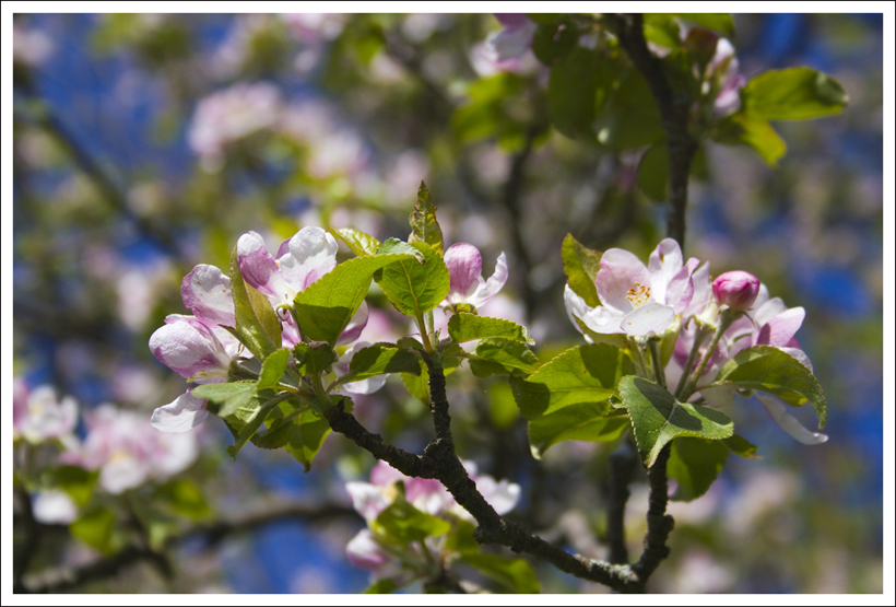
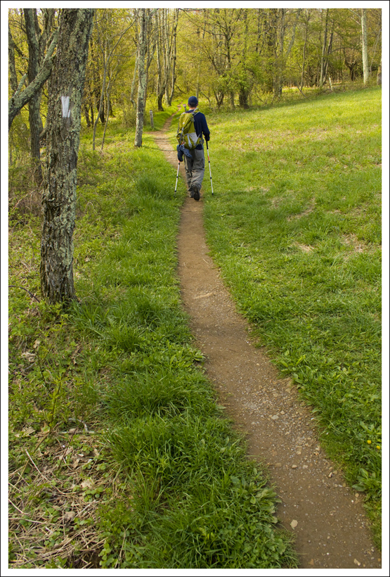


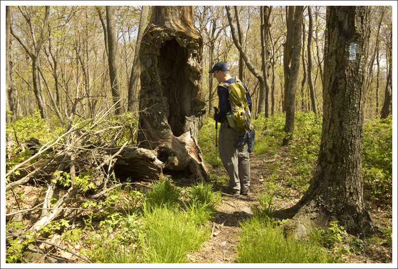


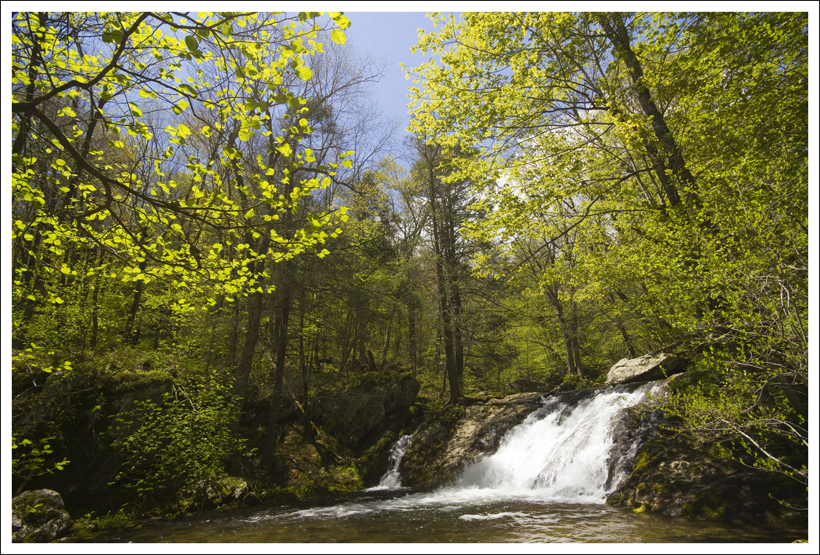
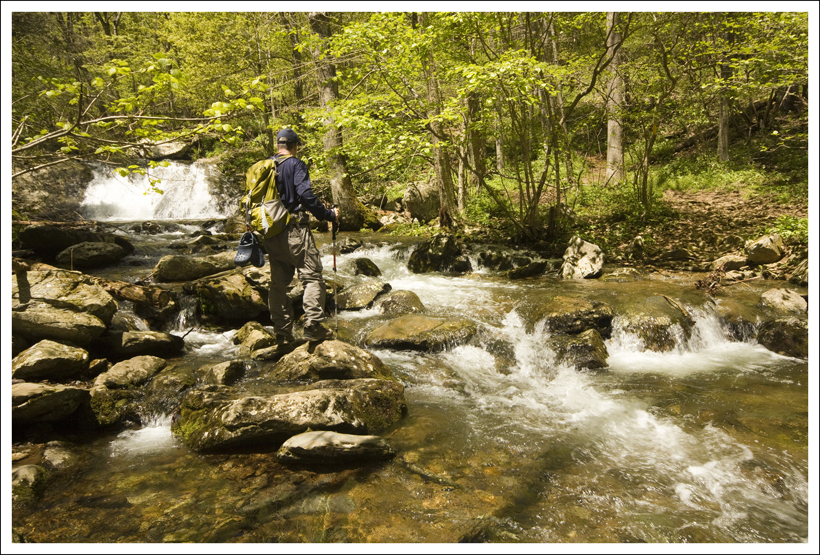


 Wookie Says…
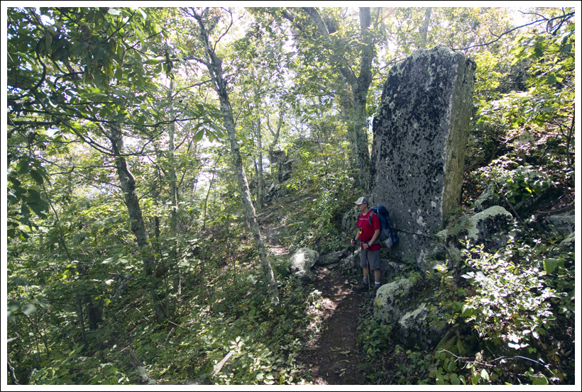