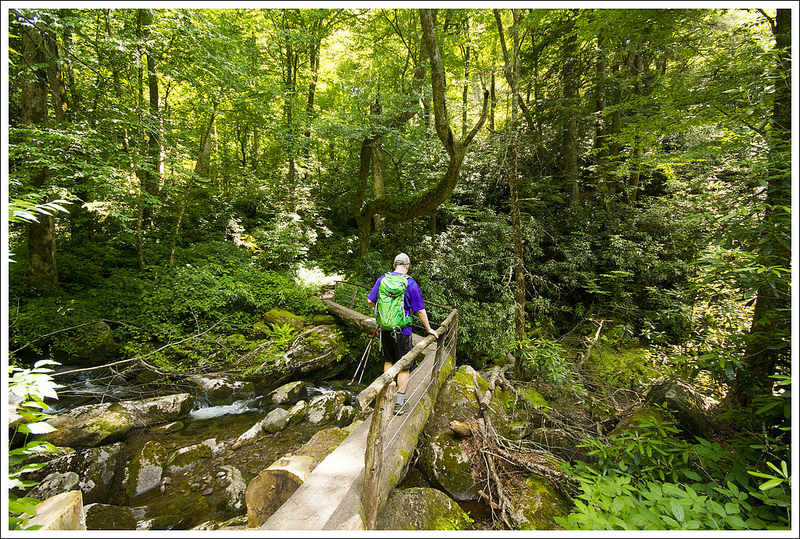
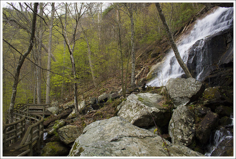
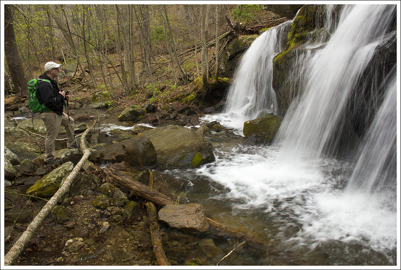
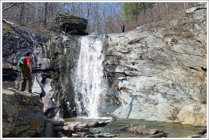
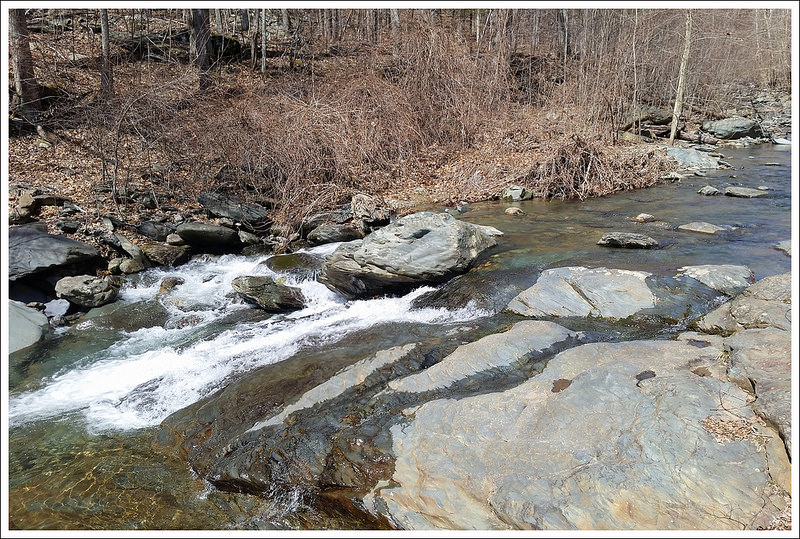
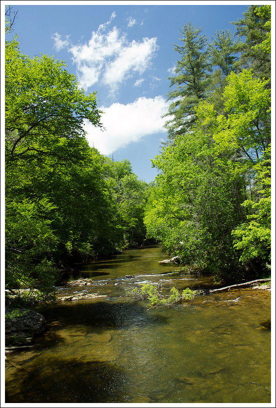
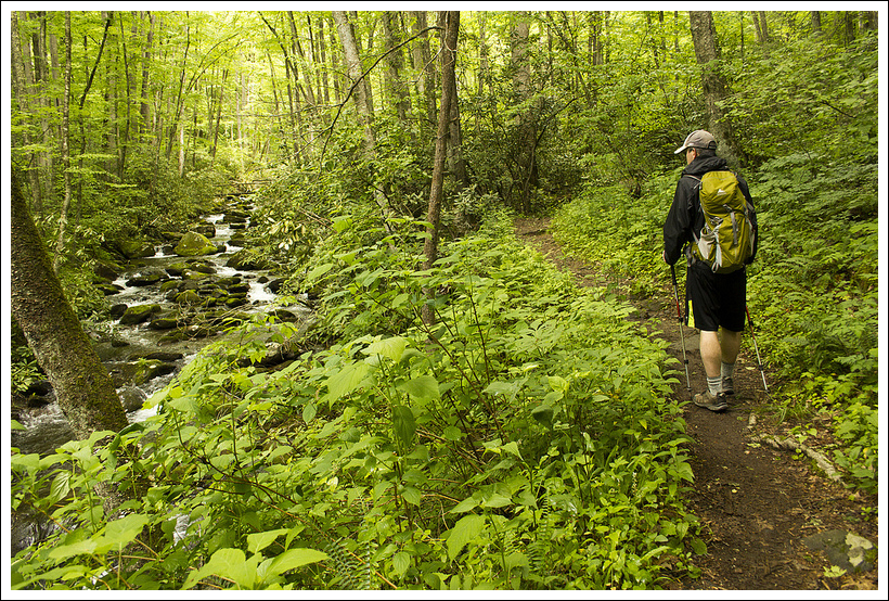
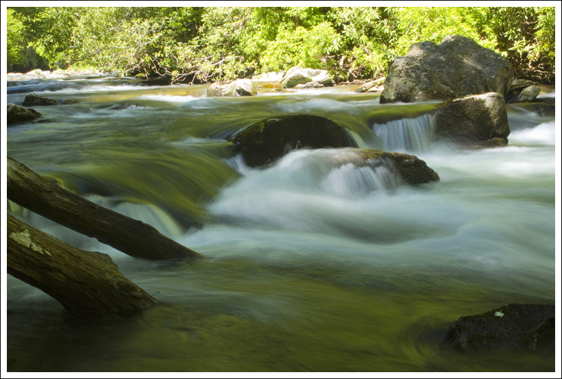
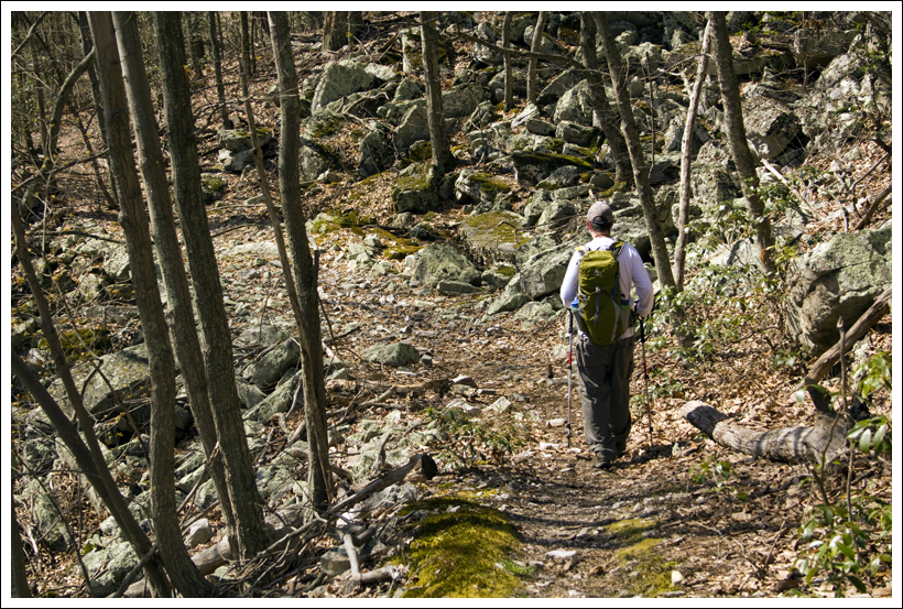
This 3.6 mile hike takes you over more than 15 water-crossings to see a series of small waterfalls and swimming holes. The main scenic draw of this hike is the visit to the Devils Bathtub – a beautiful sandstone formation in the streambed.
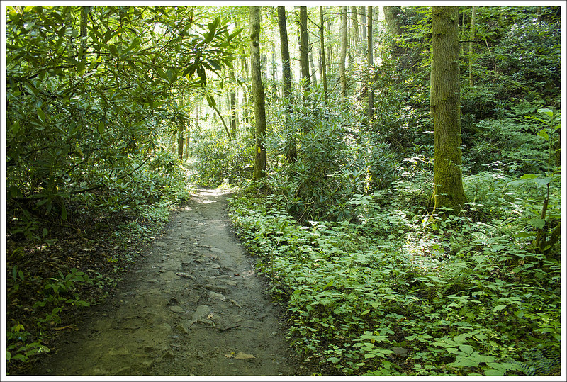
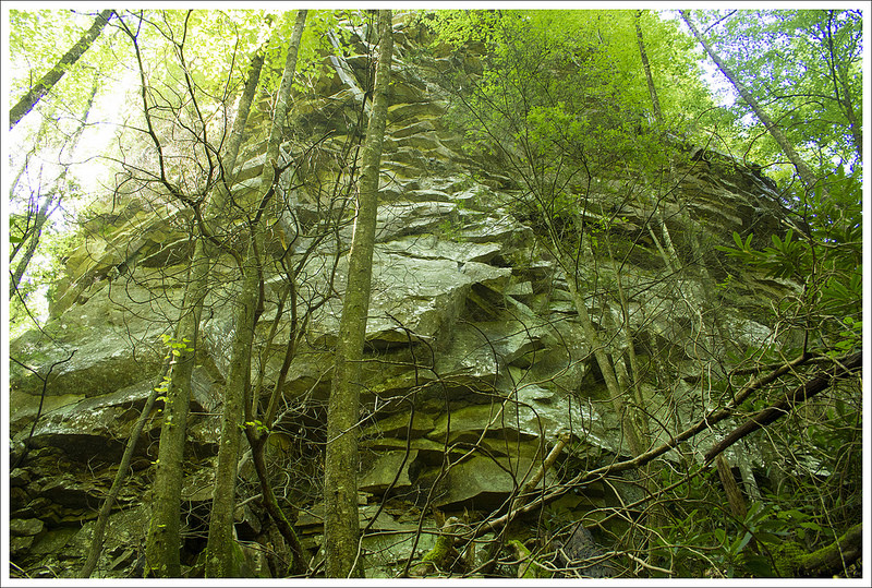
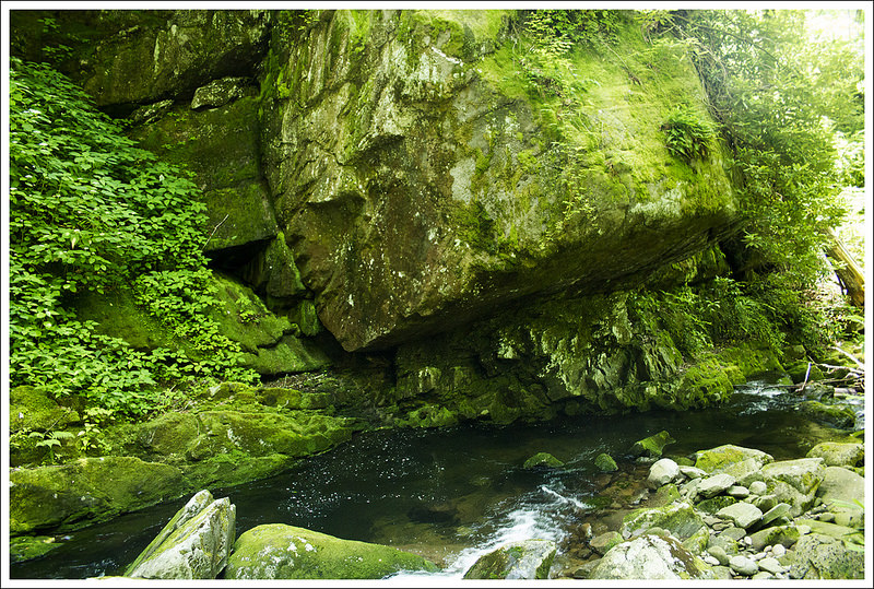
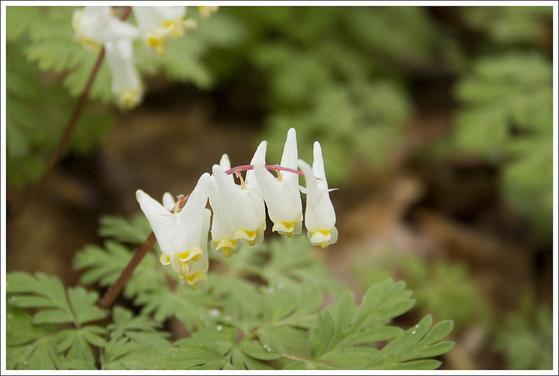
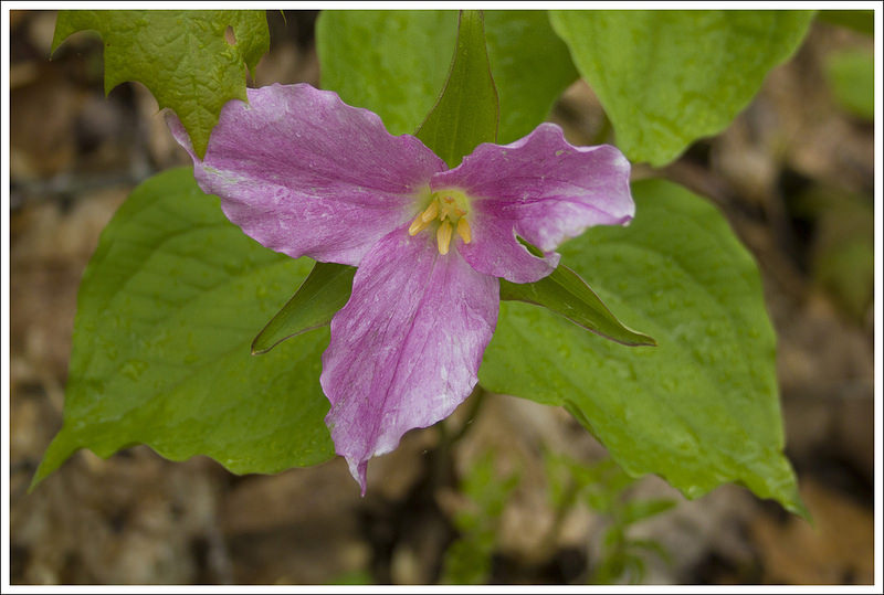
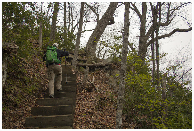
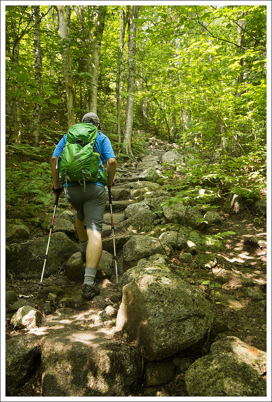
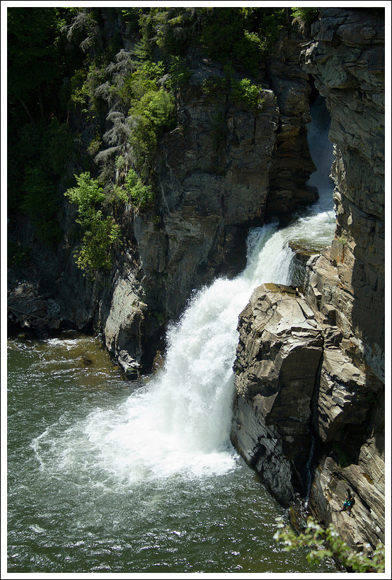
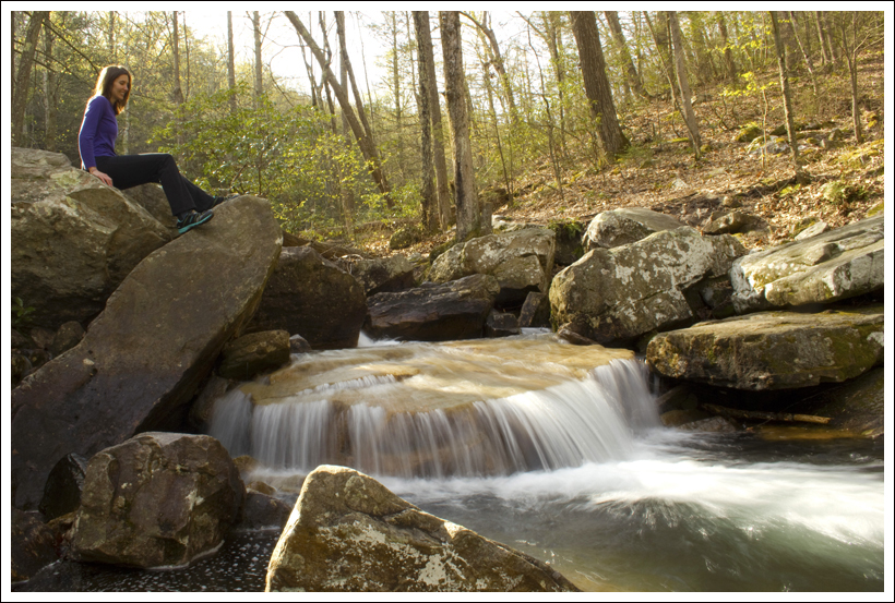
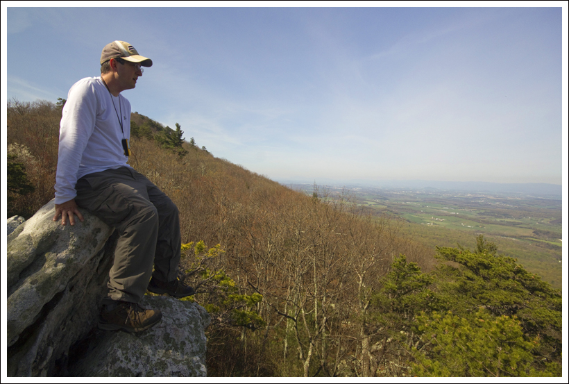
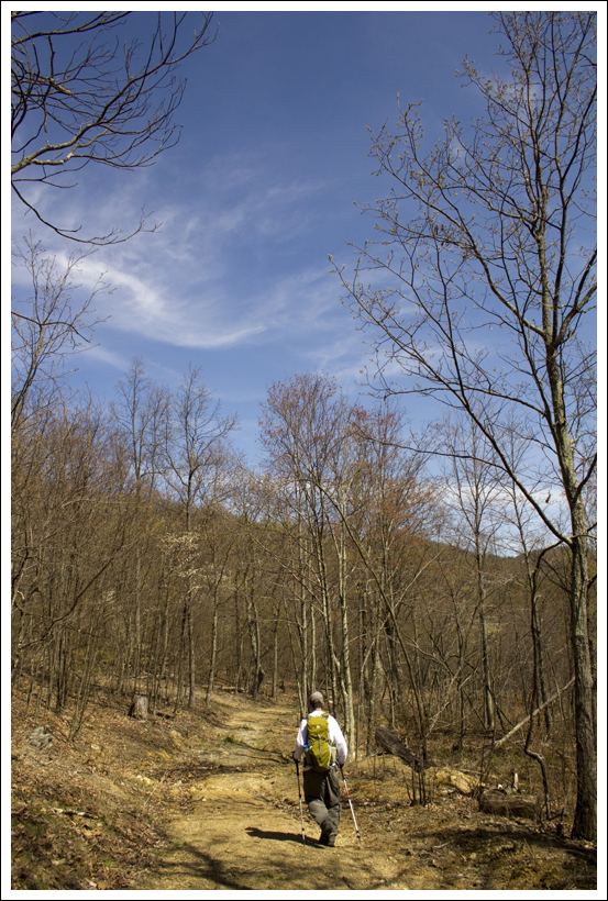
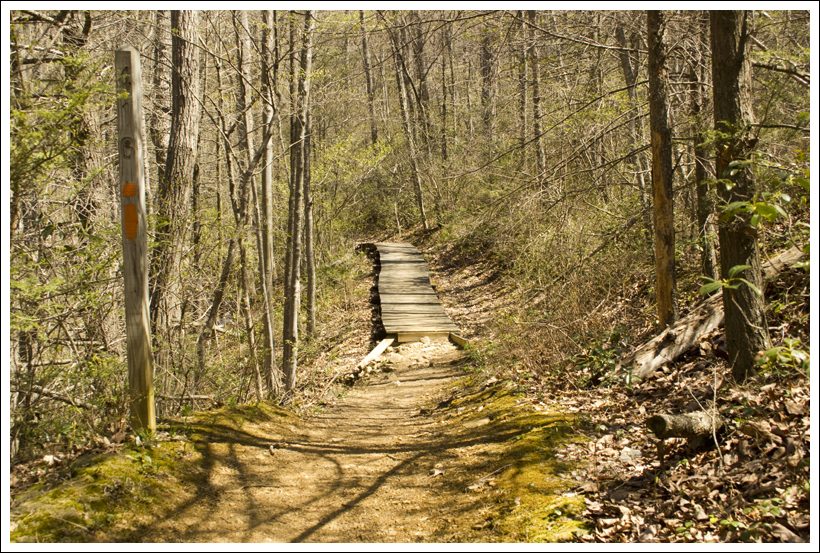
The Devils Bathtub is a perfectly clear, oval pit in the sandstone. It really does look like a bathtub! When we visited the water levels were very low. Normally the striated area above the tub forms an even larger pool. Below: Stairs at the beginning of the hike; First water crossing; Early part of the trail.
Christine Says…
The Devils Bathtub popped up on our radar after getting quite a bit of attention on the internet. Sometime after 2014, it started showing up on Pinterest, on Reddit, on lists of most beautiful places in each state – even the Weather Channel called it Virginia’s hidden gem. As dedicated hikers, we wondered how such an amazing place could have escaped our notice for so long.
As it turned out, this hike has been hiding in our plain sight for years. The route to the Devil’s Bathtub is fully outlined in Bill and Mary Burnham’s ‘Hiking Virginia’ guidebook as part of the larger Devil’s Fork loop. Burnham’s description of the scenery was far less dramatic than accounts we read on the internet. And, we’re rarely in the far southwest corner of Virginia, so we stayed in the dark like most outdoorsy Virginians.
However, on our summer trip to the Abingdon area, we finally had a chance to find out first-hand if the Devil’s Bathtub lived up to its internet hype.
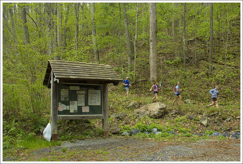
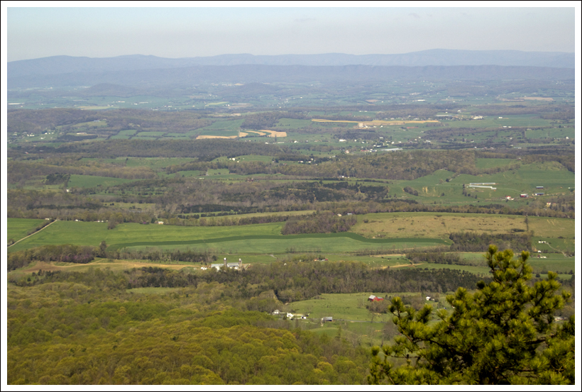
First off, the Devil’s Bathtub is in the middle of nowhere in Scott County, Virginia. There isn’t a nearby gas station to ask for directions or use the restroom. You probably won’t have any cell service, so make sure you have good directions and all your trail information ahead of time. Second, the last bit of road to get to the trailhead parking is quite rugged with mud and deep potholes in the road bed. Our Subaru did fine, but it was a bumpy ride! Third, parking for this hike is extremely limited with room for just a few cars. We visited early in the morning on a quiet, overcast weekday, so there was just one other car when we arrived. We’ve heard parking can be a nightmare for this hike, so time your visit strategically.
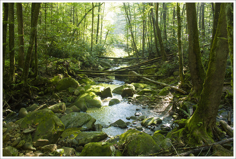
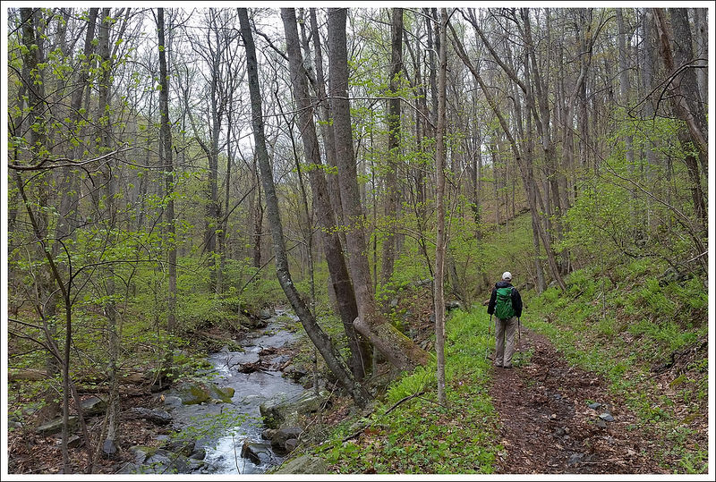
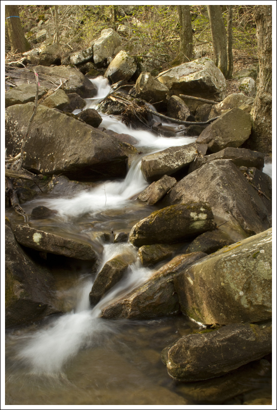
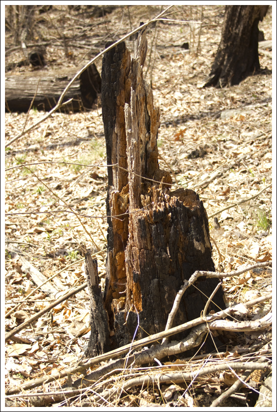
We saw dozens and dozens of these efts. Below: Scenery along the stream
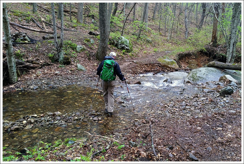
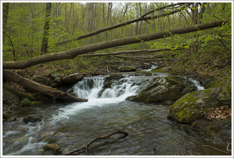
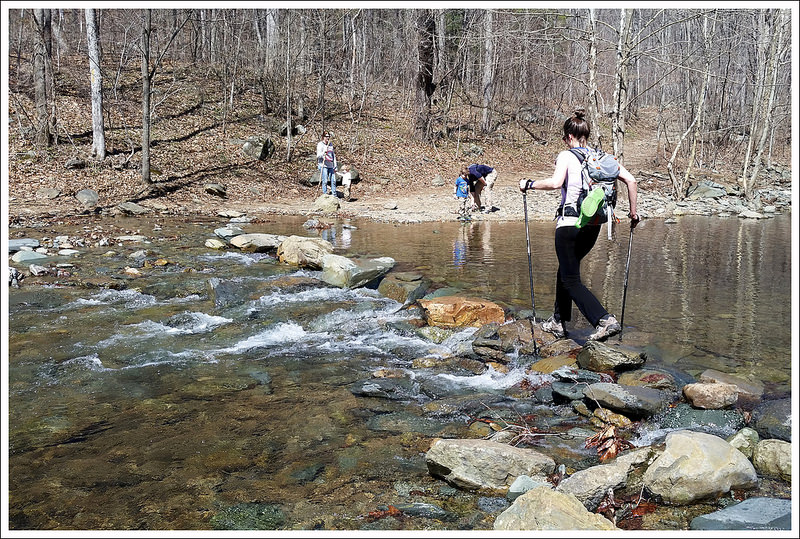
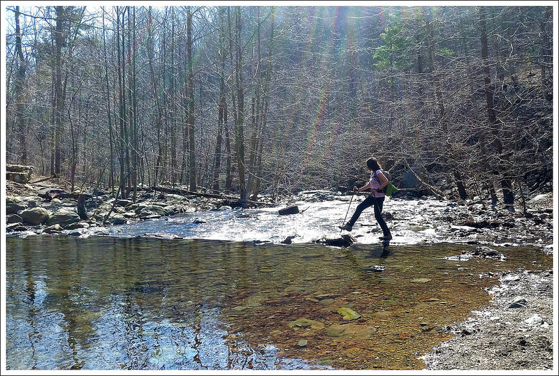
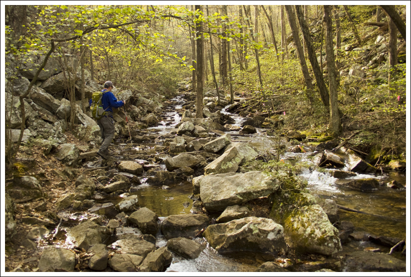
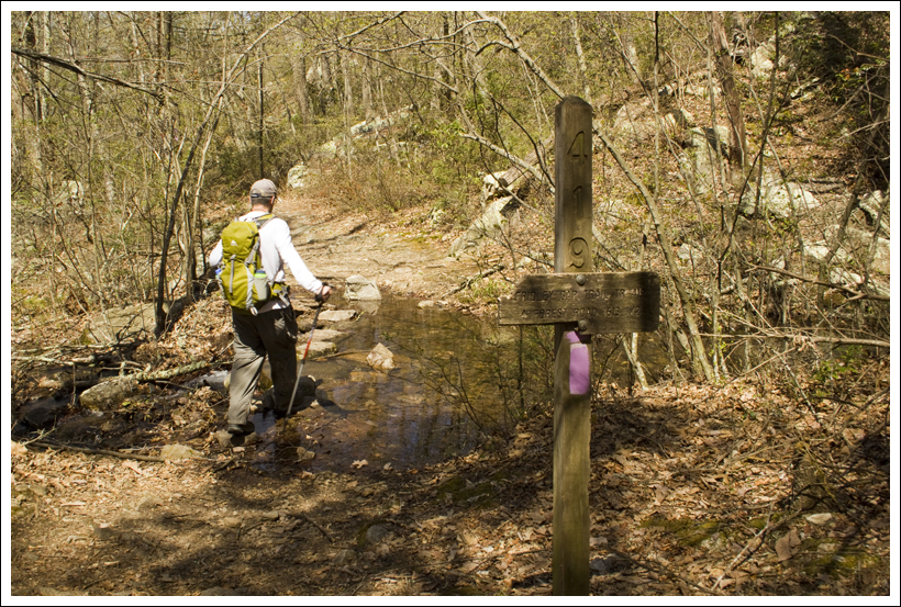
Once we got past the logistical challenges – location, road access, and parking, we were all set to see this spectacular beauty spot! The hike started at the top of a staircase at the top of the parking area. At the top of the stairs, follow the trail to the left, passing almost immediately under/around a locked metal gate. In just a quarter mile, you’ll have your first of many stream crossings. The first crossing was the widest and deepest we experienced on the hike – and we visited during drought conditions. During periods of heavier rain or snow melt, this stream crossing could be quite a bit deeper and wider.
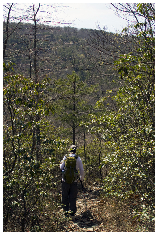
Shortly after the first stream crossing, you’ll reach marked split in the trail. You’ll want to bear to the left, following the arrow in the direction of the Devils Bathtub. The sign says it’s 1.8 miles to the Bathtub, but our GPS calculated the hike at almost a full half mile shorter by the end of the round trip. This route is also the most direct way to the scenery and is an out-and-back hike. There is a full 7-mile loop of this area, but all recent accounts say that most of the trail is poorly blazed, covered with blowdowns, and beset by aggressive wasps.
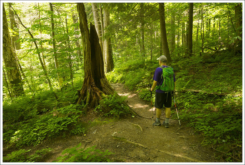
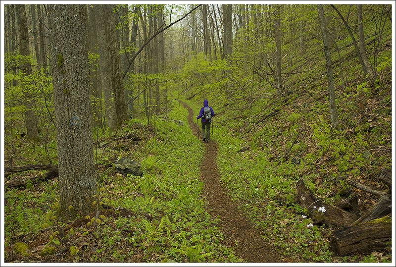
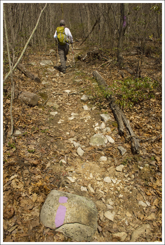
After the junction, we continued along following the yellow blazes. Even though the trail doesn’t climb much in elevation, it still provides challenges with its sporadic blazing and 15+ water crossings. It was really easy to lose the yellow blazes, as the trail is eroded and appears to have been relocated several times. We made our way by carefully looking for yellow blazes any time the trail wasn’t abundantly clear. We were lucky to visit in a time of low water, so all of the water crossings were easily passable. I imagine the way could be really tricky when there is more rain.
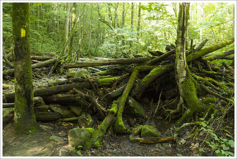
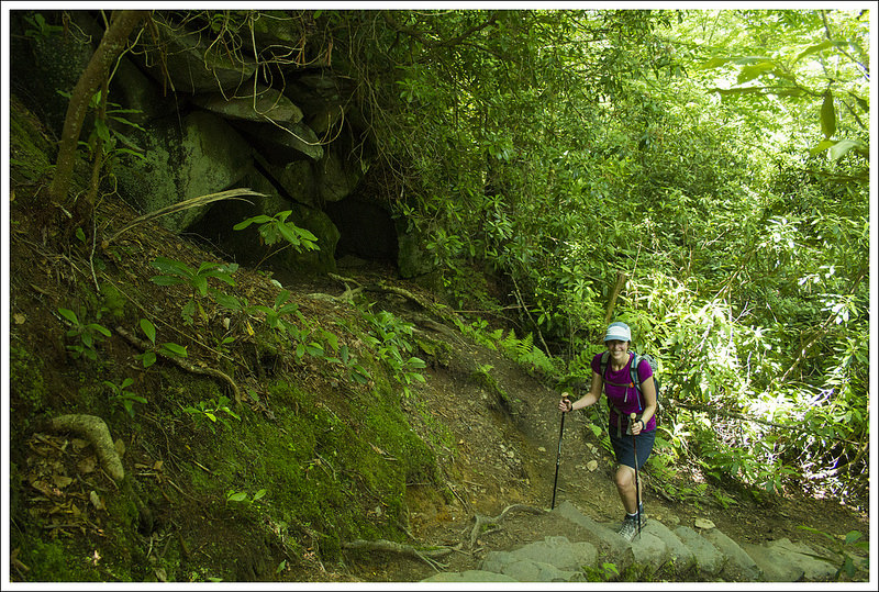
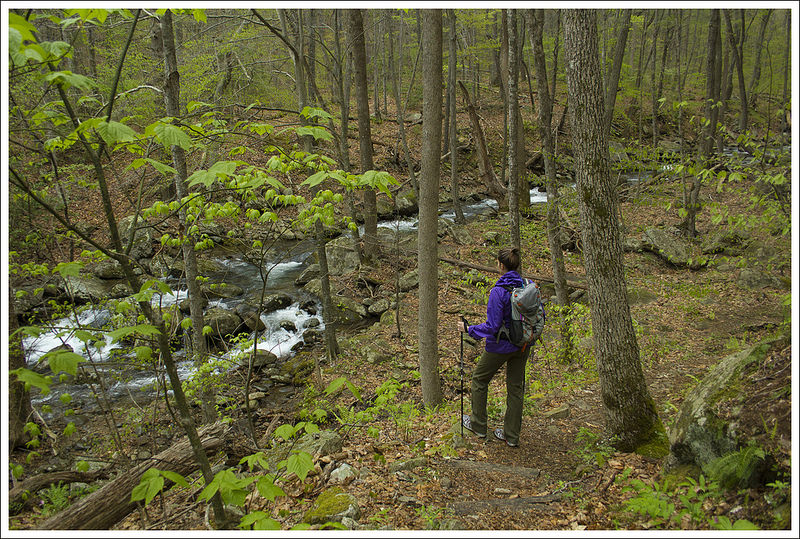
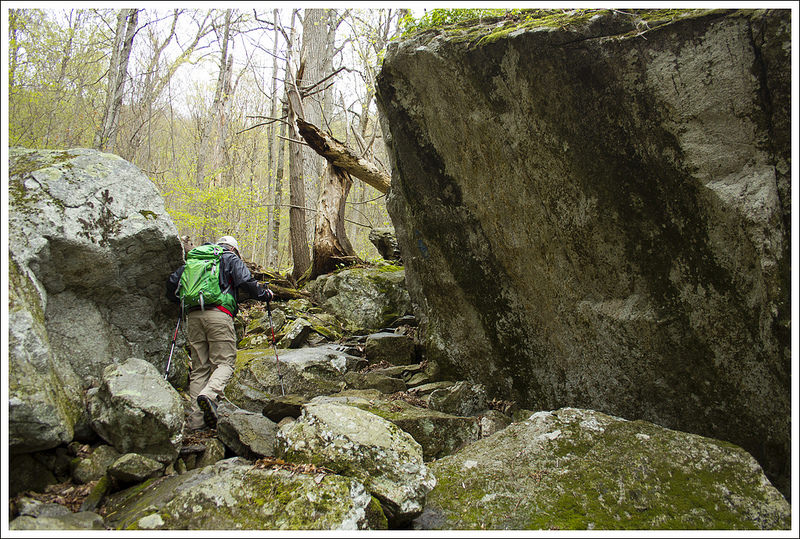
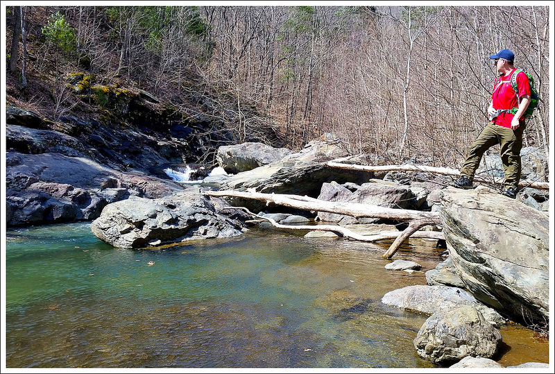
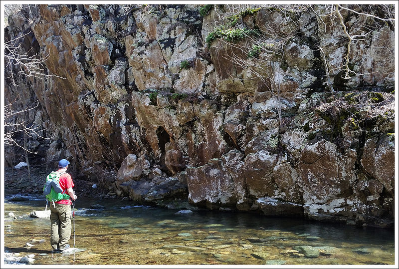
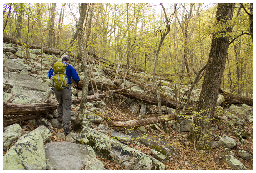
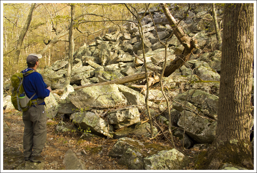
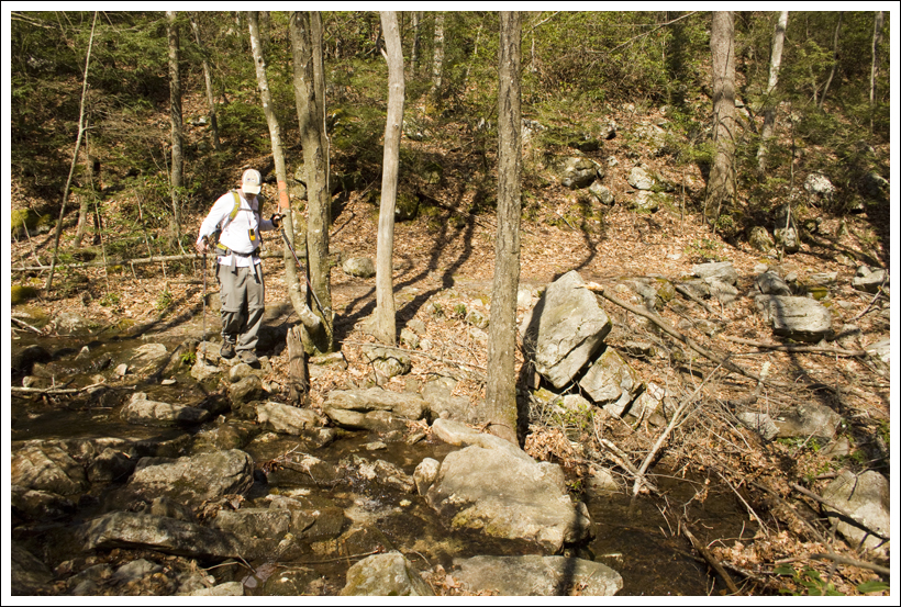
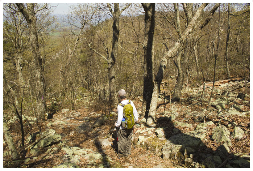
We passed a neat cliff-side that looked like it was built out of block. It was set off the trail, about 20 feet into the woods. Shortly after the cliff, the trail dipped down along an eroded bank next to the stream. There was a rope fixed to the uphill side of the trail to make passage a little easier. At the end of the rope, we reached the beautiful sandstone streambed that makes this area so popular.
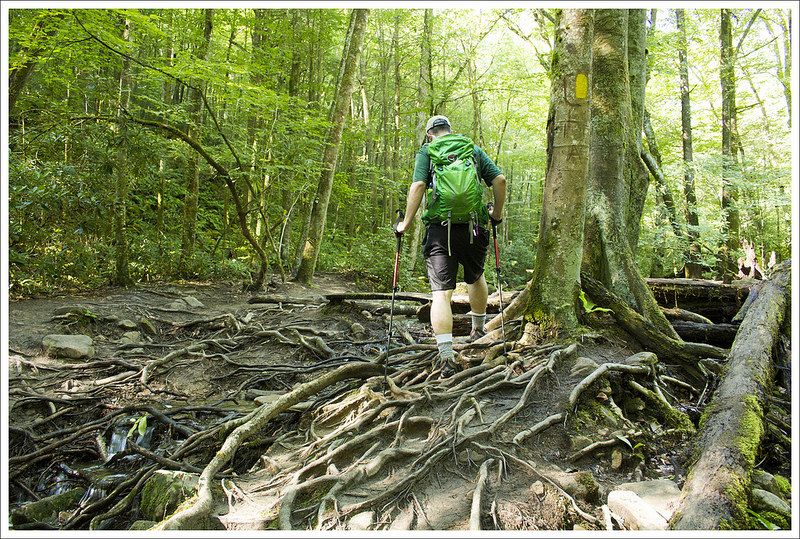
Rock Formations on the Devils Bathtub Hike. Below: More stream scenery; A rope assist along the eroded trail; Steep eroded bank
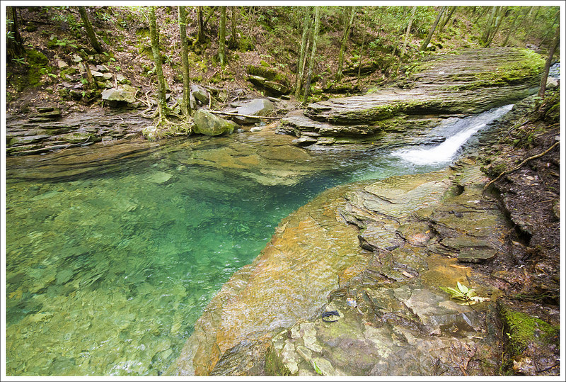
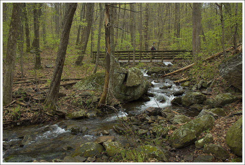
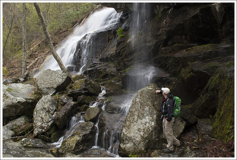
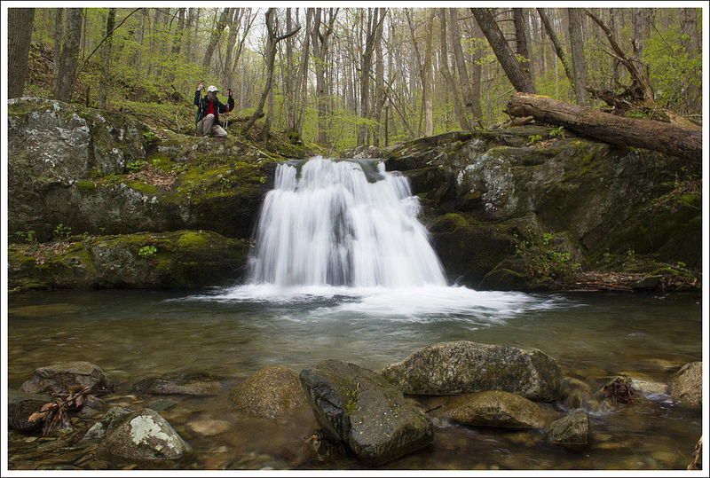
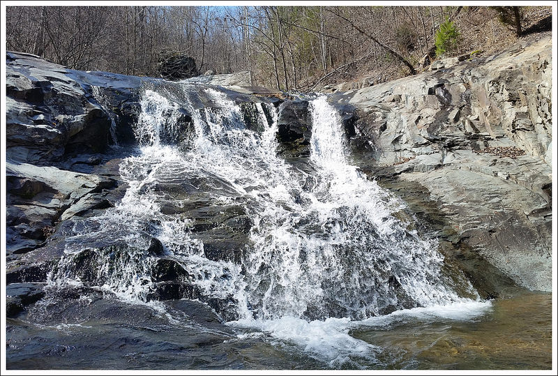
The trail crossed the stream one final time at the base of a large pool with a small waterfall. I imagine a lot of people reach this point and think it’s the Bathtub. It’s a pretty spot with deep, clear green water. But, to get to the Bathtub you should continue along the trail up a short but very steep scramble up the bankside.
At the top of the bank, a newer wooden sign indicates that you’ve reached the Devil’s Bathtub. If you follow the footpath down to the stream’s edge, you’ll find the formation at the base of another small waterfall. It’s a gorgeous spot, though smaller than I expected it to be. The water was low on our trip, so I’d say the tub was only about half full!
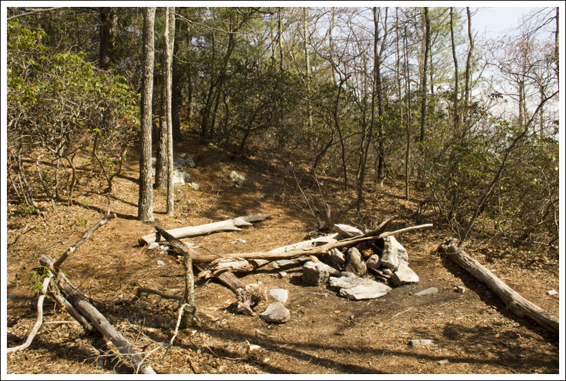
We explored and photographed the area for a while… dismayed by the enormous amount of garbage left behind by other hikers. We saw dirty diapers, Styrofoam cups, beer cans/bottles, tampon applicators, sodden socks, discarded t-shirts, empty pudding cups, a spent asthma inhaler, and countless cigarette butts. I simply can’t understand how a person can visit such a naturally lovely place, and feel alright about leaving their trash behind. Adam and I ended up carrying out three bags of garbage, and it didn’t even make a dent in what was still left behind.
After a while, a couple more groups of hikers joined us at the Bathtub, so we decided to pack up and make our way back to the car. To exit, we simply retraced our steps. On the way out, I kept thinking about all the litter we saw on our hike. If you choose to do this hike (and we hope you will) please bring a trash bag and help clean up along the way! This is a gorgeous area – but it’s overused and fragile.
Adam Says…
A friend of mine had asked me about a year ago if we had hiked Devil’s Bathtub yet. After checking out pictures online, I knew this is one we had to put on our radar. Living several hours away and the fact this is a short hike made our decision to incorporate this hike into a four-day trip to check out a bunch of hikes in southwest Virginia.
This hike does have some challenges involved – navigating to parking without reliable GPS signal, the bumpy drive on the fire road to get to parking, the often poor blazing on the trail, and the numerous stream crossings. But with a little determination, we found our way to this gorgeous spot.
Adam enjoys the Devils Bathtub. Below: Signage; Terrain around the Bathtub; The Bathtub
From the parking lot, we heading up the short flight of stairs where we met the trail. There are no signs to say which way to go, but we took a left at the top of the stairs and found we were correct. The yellow-blazed trail leads to a gate and passing through, the trail leads down to your first of about 15 stream crossings at .15 miles. When we went, the water was at a low level, so if you are hiking when there has been a lot of rain, expect your feet to get wet and plan to do a lot of rock hopping. At about .2 miles, you reach a junction with the straight fork ridge spur trail. Bear left to stay straight on the trail.
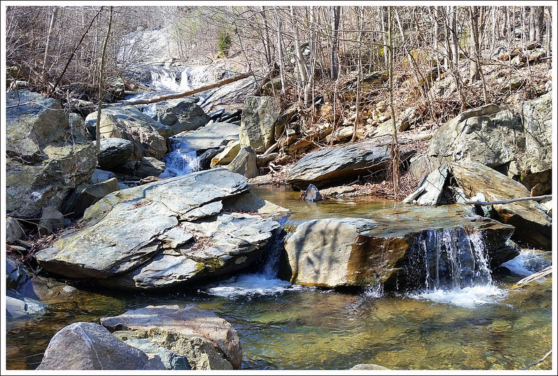
The Devils Pool. Below: Small cascades; Pools along the stream.
At .7 miles, we reached the first of the hard to navigate sections. We approached this larger creek section and saw some blazes straight ahead, but also to the right of us. We went straight ahead and up a steep bank that went down a steep, slick hill back to the creek, only to realize this section had been re-routed. We went back to the original spot to cross, bore right to the larger fire road and found the blaze to continue on the trail.
At .9 miles, at the fifth stream crossing, we had a hard time finding where the blazes continued. We reached the large stream bed and rock-hopped and walked ahead on the creek about 75 yards before finding the yellow blaze going up a steep bank to the other side. Our instincts led us the right way, but the lack of blazes made this an unnecessary challenge. We got back on the trail and just a little over a tenth of a mile, we were standing above a swimming hole, looking down to the left. From the trash and abandoned clothing left behind, we could tell many people have taken a dip in this spot before. Continue on the trail and continue to cross the stream several more times.
A beautiful green, waterfall-fed swimming hole. Below: A sampling of litter; Butterflies
At about 1.5 miles, the trail reaches a large rock formation and you scale the side of it on a narrow path, but with some assistance to an anchored rope that guides you along. You then climb down to a stream crossing and swimming hole before making your way up a very steep bank to continue on the trail. From here, the hike is relatively flat and at 1.7 miles, you reach the sign for Devil’s Bathtub. There is a small lookout over the bathtub from here, but if you want to see it up close, the best thing to do is continue past the sign and stay on the trail. When you reach the stream again, cross it and then navigate along the side (the rocks were very slippery here) until you make your way down to the bathtub at 1.8 miles. The water again was low, so we were expecting a deeper basin of water from what we have seen in some pictures. The rock around the bathtub was covered in algae and very slick, so be careful!!
It took us a while to just remove enough trash around the site to get some decent pictures. As Christine mentioned, please bring a trashbag and help pick up around the area. The devastation of litter here made me quite sad that people would treat such a picturesque spot with such disrespect. We made our way back the way we came and saw a few people on our way back.
The green water plunging over and into the Devil’s Bathtub makes for one of those truly magical places in Virginia. If you are ever down in the southwestern part of Virginia, put this on your must-hike list.
Trail Notes
Distance – 3.6 miles
(Check out the stats from Map My Hike)*
Elevation Change – 580 ft
Difficulty – 3. The climb is easy and very small/gradual. The challenge factor is increased by the number of water crossings you must negotiate.
Trail Conditions – 2.5 The trail is eroded in numerous places and there is a real issue with litter.
Views – 0. None on this hike.
Waterfalls/streams – 5. The stream scenery is gorgeous!
Wildlife – 2. We saw lots of newts.
Ease to Navigate – 2.5 The trail is poorly blazed and hard to follow in several spots.
Solitude– 2. We visited on a quiet weekday, and still saw multiple groups of people.
Directions to trailhead: Parking coordinates: 36.819106, -82.628852. This location is very isolated and not really close to anything. It’s best to use the GPS coordinates and navigate fro=m your home direction.
* MapMyHike is not necessarily accurate, as the GPS signal fades in and out – but it still provides some fun and interesting information.
We’re back in the Smokies region for the next three hikes! Ramsey Cascades is the tallest waterfall in the park. It’s also one of the most popular – despite the fact that the hike is a strenuous 8-miler!
We’ve seen a number of the big waterfalls in the Smokies. Ramsey Cascades might be one of the prettiest. Below: Adam at the trailhead; The first part of the trail was along an old road; You could see and hear water for most of the hike.
Adam Says…
Our May vacation plans fell through due to a sick pet, but we were fortunate enough to slip away on a last-minute four day trip to the Smokies in mid-June. When we vacation, we tend to go hard. We try to pack in as much as we can during every waking moment of the day. While it may not be as relaxing as some people like on vacation, we feel we want as many experiences as possible. We like to tell each other that we can be tired and act like zombies at work for the first day back, so we stay “on the go” during vacation. So, to maximize our time, we woke up around 4:30 a.m., packed up the car, and headed out to the Smokies. When we got to the trailhead, it was a little after noon and the temperature and humidity made it feel like over 100 degrees. We typically like to start hiking (especially in the warmer months) early in the morning before you can feel the height of the day’s heat. This time, we were stuck with it. The small parking lot for the trail was packed with cars, so we ended up having to park a little down the road. So, we quickly got on the trail and pushed on. Most of the trail was fairly shady, so not being in direct sunlight helped.
The foot log across this chasm was narrow and long. Below: The chasm beneath the log bridge; Another view of the bridge’s narrowness; Christine under the giant tulip poplar.
The trail starts on a wide gravel fire road which made for easy footing. One family had ventured out before us when we were trying to find parking. We saw the mother of the family doubling back along the trail, looking for the rubber foot that was lost on one of her children’s trekking poles. When we came upon the rest of the family, it looks like they sent the mom off about a mile to look for it. We felt bad that the mom was spending all of this time searching while the rest of the group was just relaxing. At 1.5 miles, you reach an area that comes to edge of the stream. To the left, the trail goes through a deep tunnel of rhododendron. It is here the trail begins to climb and the trail becomes narrower.
At 2.1 miles, we reached a long foot log bridge. As I’ve stated before, I hate man-made things when it comes to heights. We had just passed another family on the hike, so I thought I would try to cross before they got there. I got a little ways along, chickened out, and returned to the start of the bridge. I knew it would take me a while to muster the strength to do it and I didn’t want to feel the pressure of judging eyes as I made my way across. I debated internally if I should just wait here and let Christine continue on, but I knew I would regret not making it to the falls. We let two families go by, one boldly taking selfies on the log. After they were out of sight, I decided to give it another try. As you can tell from the picture above, the bridge is only wide enough for an average person’s feet. I’m not sure how far the drop would be if you fell off, but I would guess you would likely break something if you fell. I decided to shuffle my feet side-by-side, while gripping the handrail white-knuckled. During half of the traverse, I could feel the bridge bounce slightly up and down with each step, not easing my comfort-level at all. I finally made it across and double-checked my map. I was hoping there was a loop on this hike, but since this is a straight out-and-back hike, I’d have to face this beast again. I rested on the other side a while, because I felt like I had just burned 2000 calories through the stress and adrenaline used crossing the log.
After crossing the narrow log bridge, the trail became increasingly steep and rugged. Below: Hiking along the rocky part of the trail; The second L-shaped log footbridge; Rocky trail; Arriving at the falls.
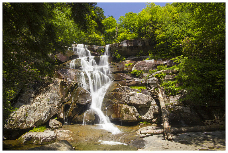
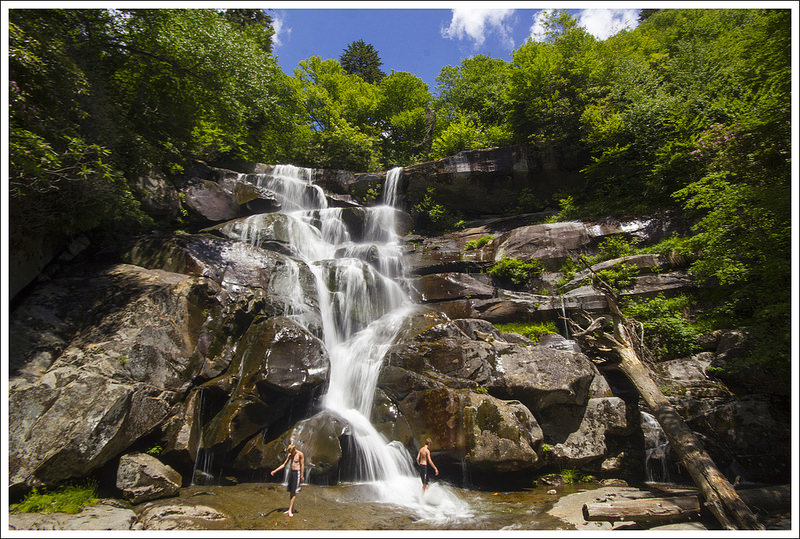
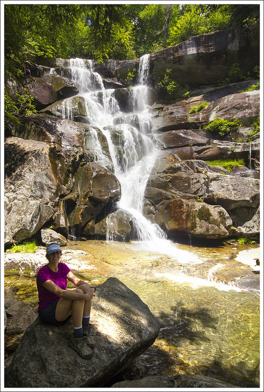
At 2.6 miles, we came across the three large tulip poplars. The size of these trees was truly impressive! There was a large group of high school JROTC students stopping here, so we decided to take time to appreciate them more on the way back. We continued up the steep trail, which was very tough in this muggy, hot weather. Eventually, at 4.0 miles, we arrived at Ramsey Cascades. The waterfall is probably 90 feet across and plunges down through cascading rocks over 100 feet. The rock outcropping to view the falls was packed with people, but we waited a while and eventually most of them left. This is one of the prettiest waterfalls in the Smokies, so it was worth the sweat and effort (and maybe even crossing that log bridge).
We made our way back fairly quickly since the hike was mostly downhill. We stopped to enjoy the large tulip trees along the way. When I got to the bridge this time, I folded up my trekking poles (which I didn’t do on the way across initially) and immediately went across. I was much quicker this time across, but it still took a toll on me. I rested again, ate some jelly beans to replenish my sapped energy, and continued back. The rest of the trip was easy and we made quick time back to our car.
We cranked up the AC in the car and drove to our hotel in Gatlinburg. Gatlinburg was even hotter than the trail, so it was hard to get cooled down for the rest of the day. But, we were so glad we made the trip out to view Ramsey Cascades.
Christine Says…
It was a little nuts to hop into the car at five in the morning just so we could pack one more day of hiking into our whirlwind, too-short, almost-completely-unplanned trip to the Smokies. We’ve visited the area for three consecutive years, but there are still so many mountains and streams for us to explore. We love coming back to this area!
The first hike on deck was Ramsey Cascades. It’s one of the park’s most popular and impressive waterfalls, and we’ve wanted to hike it for a while now. We arrived to the area a little before mid-day, so we decided to fuel up with a quick lunch at The Sub Station. It had great reviews on Yelp and it was right along our route. We scarfed down pulled pork sandwiches and then made our way to the Greenbrier section of the Smokies.
Arriving right at noon, the parking lot was already jam-packed with cars, so we had to find a pull off further down the road. As soon as I stepped out of the car, the heat and humidity hit me like a sucker punch. I looked at Adam and said, “We’re not used to this heat… this is going to be a brutal hike!” The area went on to set several heat records during our visit.
The first part of the hike followed an old gravel road. It climbed steadily uphill, but was nicely graded and easy to traverse. We saw lots of rosebay rhododendron starting to bloom along the trail. We also enjoyed the constant sound of running water from the Little Pigeon River.
Some people opted to swim in the basin beneath the falls. Below: A vertical version.
About a mile and a half in, the gravel road ended and the route became a narrow footpath through the lush green forest. This section of the hike followed alongside the Ramsey Prong which drains down the side of 6621-foot Mt. Guyot – the second tallest mountain in the park. As we walked, I tried to focus on the loveliness of the trail instead of how I was feeling. I was utterly gassed. The heat was getting to me and making me feel weak and lightheaded. I kept drinking water, but it just made the sandwich I’d had for lunch churn in my stomach. Maybe eating had been a bad idea. I kept pushing my physical discomfort to the back of my mind and focusing on putting one foot in front of the other. Sometimes, it just what you have to do!
At 2.1 miles, we reached the narrow log bridge that Adam described so thoroughly. The Smokies are full of these split log bridges, but this was the longest and highest one we’ve seen! I suppose these log bridges keep streams cross-able when water is high (as opposed to a rock hop) and are less expensive than real bridges to build/maintain. I like the way they blend into the natural scenery so nicely.
After crossing the bridge, we soon reached a grove of giant, old growth trees. There are three tulip poplars that you’ll notice immediately. They rise, straight and proud, from the forest floor – all of them dwarfing the other trees around them. They were such impressive trees!
The last mile to the falls was increasingly steep and rocky. We climbed stone steps, crossed another L-shaped log bridge, scrambled over boulders, and stepped over a couple shallow streams before reaching the falls. At first, we could just see it through the woods, but after climbing over one last large boulder, we came to a big clearing.
We stopped by the three giant tulip poplars again on the hike back. Below: Adam crossing one of the small streams; Back across the scary footbridge; Pretty green Smokies forest.
The falls were so impressive, plunging over 100 feet down the mountainside into a beautiful pool. There were tons of people gathered on the rocks. It was hard to find a place to sit and relax, but we eventually did. Despite warning about treacherous conditions, people were still swimming, wading, and climbing on rocks around the falls. We saw one young teenager come very close to taking a terrible fall onto the rocks. He was lucky that he caught himself at the last minute.
We stayed and enjoyed the falls for quite a while. This gave me a chance to cool off and eat a little sugary snack. That definitely made me feel better and helped my dizziness and fatigue. Eventually, the crowd thinned and we had the falls to ourselves. Or I should say mostly to ourselves with the exception of bees! I don’t know why it is, but there are massive numbers of bees living in hives around the falls. There are hundreds of them and they’re constantly buzzing around. Fortunately, they’re not aggressive and seemed happy to share the falls. Just be careful about sitting or putting your hands down. I’m sure they’d sting if someone tried to squish them!
After taking a bunch more photos, we made our way back down the trail. The downhill hiking went really quickly. Adam crossed the scary log bridge boldly on the return trip. We were back at the parking lot in half the time it took us to climb up!
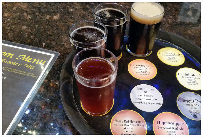
Great steak dinner at Smoky Mountain Brewery post-hike. Below: Smoky Mountain Brewery flight; Pretzels and beer cheese!
Before we got in the car, I was very tempted to jump into the Little Pigeon River. The spot where we parked was right next to a deep, cool swimming hole. Adam told me it was a bad idea and that I’d be soaking wet in the car – so phooey – I passed on my chance to plunge in!
We had a short drive into Gatlinburg from the hike. Because we didn’t plan ahead for this trip, our choices for lodging were fairly limited – but we picked a winner. We ended up stayed at the Mountain House Motor Inn. It was clean and comfortable, with a super-strong air conditioner. It was also located within walking distance of all the downtown restaurants and shops.
We checked in, showered, and headed out for a great dinner at the Smoky Mountain Brewery! What a great first day of this mini vacation.
Difficulty – 4.5. The trail starts off fairly easy and gradual, but becomes steeper and rockier after the first 1.5 miles. The last few tenths of a mile to the falls are a scramble over boulders.
Trail Conditions – 3. The trail is rocky in places. There is also a long, narrow log bridge that might intimidate some hikers. It crosses a chasm over a stream and feels precipitous to anyone afraid of heights.
Views – 0. No views here – it’s all about the stream scenery!
Streams/Waterfalls – 5. The stream is beautiful and Ramsey Cascades is one of the park’s prettiest waterfalls.
Wildlife – 0. There were so many people on the trail we didn’t see any animals.
Ease to Navigate – 4. The trail is simple to follow. There aren’t any turns or junctions.
Solitude – 1. The trail is one of the park’s most popular.
Directions to trailhead: From Gatlinburg, TN, take US-321 N/East Parkway for about 5.5 miles. Turn right onto Greenbriar Road. Follow this for 3.1 miles before turning left onto Ramsey Prong Road. Go 1.5 miles and you should reach the parking lot for the trailhead. The trailhead starts at the end of the parking area. Coordinates: 35.702730, -83.357599
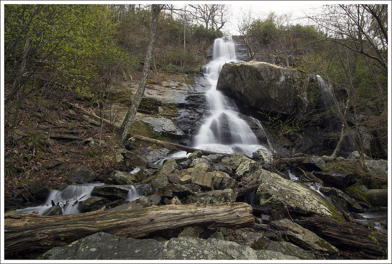
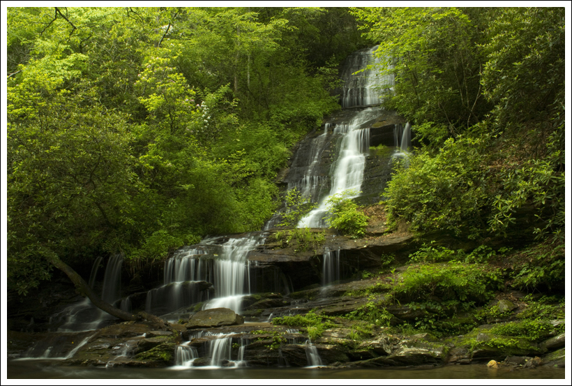
Beautiful Apple Orchard Falls plunges about 200 feet down the mountainside. Below: Even the fire roads were scenic on this hike; Abundant wildflowers including Dutchmans Breeches; There were several stream crossings to negotiate.
Christine Says…
Apple Orchard Falls has been on our ‘must hike’ list for years now, and I’m so glad we finally got out there and did it! It’s a bit of a drive from our home-base of the central Shenandoah valley, but it was well worth the trip! We hiked it on a cool, rainy day in mid-April. We thought we’d have the trail all to ourselves, but as our car bumped along the forest road nearing the parking area, a runner went by. Then three more runners… and then a cluster of ten. Pretty soon we realized that there was some kind of race going on in the vicinity. It turns out we picked the same day as the Promise Land 50K for our hike. We ended up sharing the first half of our six-mile route with 300+ trail runners.
They were all friendly folks, but it was a little stressful to constantly be looking over my shoulder, watching to make sure there wasn’t a racer on my heels, needing to pass. I certainly didn’t want to get in anyone’s way as they cruised toward victory or a personal record! I still enjoyed the gorgeous stream scenery as we ascended alongside North Creek. The sound of the water was soothing. The hillsides along the trail were covered with trillium and purple wild geraniums. The air was filled with a light misty rain and all the trees were unfurling their brilliant spring green leaves. With all these pleasures along the trail, I tried my best not to let the constant stream of passing racers disrupt the zen-like peace.
Christine checks out the creek early in the hike. Below: We hike the loop on the same day the Promised Land 50K was running. It made for a crowded trail; Trillium was blooming everywhere; Pretty little rapids on the creek.
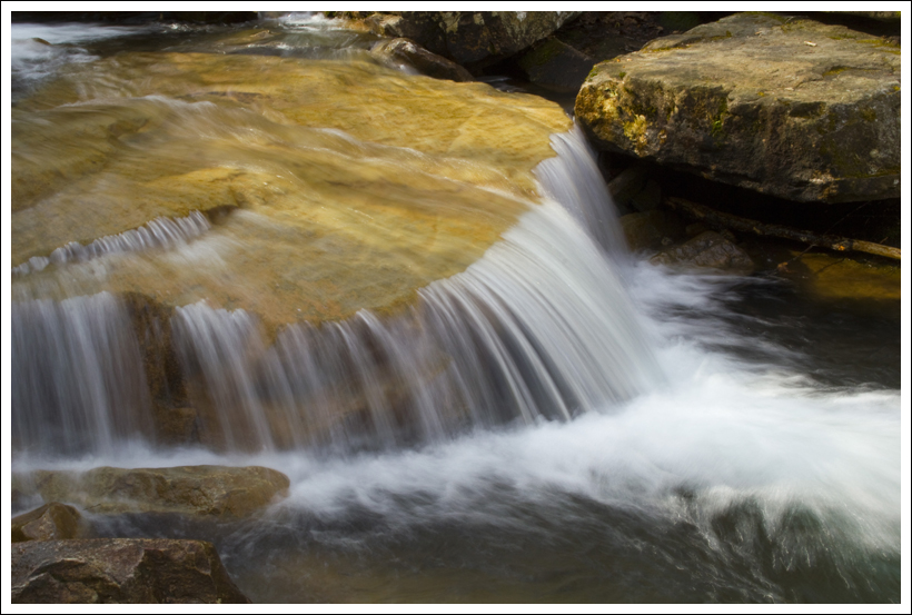
The trail was in great shape and ascended steadily and moderately uphill. There were several sturdy footbridges across the creek on our hike up. Around 1.3 miles into the hike, the climb became a little steeper and rockier. Right before reaching the base of the falls, we passed through a jumble of huge boulders. At first, we could only see the falls through the trees. They were majestic, but obscured by the foliage. We continued uphill, making a wide switchback before coming to a curved wooden bridge and a viewing platform at the base of the fall’s largest plunge.
Adam set up my tripod and I spent some time photographing the waterfall from a variety of angles. I wish the trees around the falls had been a little more ‘leafed out’. The green would have made an even more attractive frame for the falls, but it was still very nice. I was challenged by the rain – which was beginning to fall at a steadier pace. Droplets kept landing on my lens, and making blurry bubbles on each of my photos. I used a hat as an umbrella as much as I could. While we were enjoying the waterfall, the bulk of the racers passed us by.
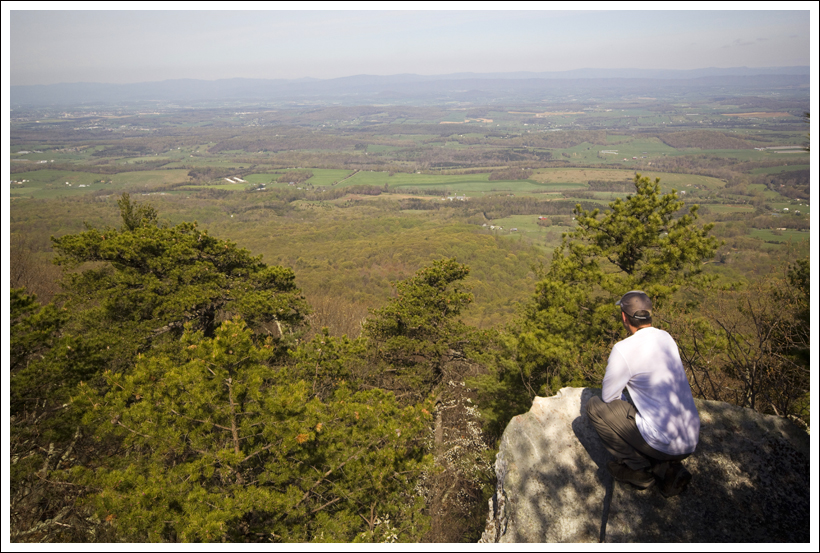
After leaving the falls, we climbed the 175 stairs above the falls. About halfway up the stairs, we caught our one open view of the hike – a pretty peek out over a spring green valley. Shortly after the top of the stairs, we passed another small waterfall. There was a nice established campsite near the smaller fall. What a idyllic place to spend a night! In fact, we saw many great campsites all along this loop. I think it would make a great beginner backpacking trip or short gear shakedown route.
There were several sturdy, well-constructed bridges on the trail toward the falls. Below: Just before reaching the falls you climb through an opening between huge boulders; The viewing deck for the falls is very nice; Adam checks out the falls.
About a third of a mile past the small waterfall, we reached Apple Orchard Road, which is a grassy fire road that connects to the Cornelius Creek trail. The racers all continued uphill toward the Blue Ridge Parkway. We turned right and followed the fire road for about a mile to its intersection with the Cornelius Creek Trail. Fire roads are typically sort of dull, but this one was actually quite nice – lush green, curvy, and decorated with wildflowers – more trillium, geraniums, violets, and enormous dense patches of Dutchman’s Breeches.
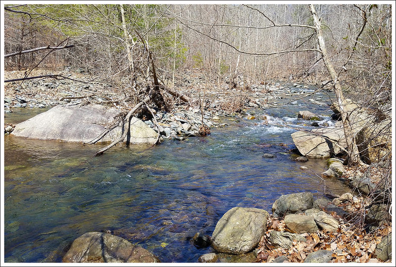
The Cornelius Creek trail was probably my favorite part of the hike. The racers were off our tail, and I could fully focus on the spring forest and sound of flowing water. The rain was coming down steadily, so my photo opportunities were a bit limited. Hopefully, I captured enough to adequately convey the feel of Cornelius Creek. It was lovely with so many small cascades and swimming holes. The only real challenge on this part of the hike were the two significant stream crossings. The first (pictured at the top of the post) was wide, but not very deep. Our toes got a little wet. But the second was quite deep, wide, and fast-moving. We packed all of our camera gear and electronics away in dry bags and plunged in. Even rock-hopping, the water came halfway up to my knees. The footing was small, shifty, and slick! Thankfully, we made it across without falling completely into the water! The last bit of walking was done with sodden shoes and socks – that squishy feeling is always so weird!
When we got back to the car the first thing I did was take off my soaked shoes and socks and put on flip flops! Then we were off on our way for a well-deserved lunch at Peaks of Otter!
Adam Says…
We got up early to hit the road and beat the crowds on this hike. With a gloomy day with some rain scheduled around the early afternoon, we wanted to make the best use of our day. When we first saw the runners on the gravel road, I thought well at least they are going in the opposite way. We parked our car at the end of the road and there was a race stop set up for people to check in, get some snacks and water and keep running. Little did we know we would see most of them all again on the trail.
We got out of our car and found out that there were going to be runners on the trail. We thought we would at least try to get a head start, so we jumped on the trail right away. We took the blue-blazed Apple Orchard Falls trail left of the kiosk that came to a wooden bridge almost immediately. We soon came across the first runner of the day on the trail, who we heard ended up coming in 2nd in the race. Along the trail, there were funny signs to try and inspire the runners along the way (and most were done with Game of Thrones references). At .2 miles, take a right at the intersection to stay on the trail.
A view into the valley on our way up the stairs. Below: Adam takes in a side view of the falls; Climbing the famous stairs, the smaller waterfall above Apple Orchard Falls.
The trail continues along North Creek for a steady uphill. At 1.2 miles, you reach a couple of bridges and a small creekside campsite. Crossing over the second bridge, the trail becomes steeper uphill. Eventually, you get some views of the falls to the right as you make the climb up. But don’t worry, the trail leads right up to the falls. The climb up to the falls is also very steep. But, as you reach the falls at 2.0 miles, there is a nice bench and platform, inviting you to take your time to enjoy the views. We stayed here for a while and saw a ton of runners pass by. Some of them just took a quick glance, some walked slowly by, but one guy stopped to take a picture. I guess the runners had different levels of competitiveness and different levels of exhaustion at this stage of the race.
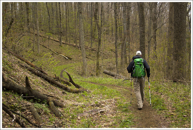
The trail continues on and winds around the hillside before beginning a series of stairs. Along the climb, there was a nice viewpoint that gave you glimpses of mountains to the west. We continued uphill along the trail until we reached another waterfall around 2.3 miles. There was a nice campsite by this waterfall also and we thought it would be a great overnight stop for a backpacking trip. At 2.5 miles, we reached a junction with a fire road. We took this fire road to the right. At 3.7 miles, the trail meets a junction with the Cornelius Creek Trail. We headed straight to start the Cornelius Creek Trail. This trail descends quite steeply. As we had seen the runners on this trail when we first arrived at the parking lot, I felt that I too was having to run down the steepness of this trail in the beginning. Be careful where you step, since the trail is incredibly steep and filled with loose rock, begging for a twisted ankle or fall. At 4.2 miles, the trail runs along Cornelius Creek.
Christine walks along in the rain. Below: Most of the hike closely follows water; A lovely little cascade on the Cornelius Creek Trail; Post hike beers at Apocalypse Ale Works.
Cornelius Creek was a long exposure photographer’s dream. There were so many spots where you saw small waterfalls and swimming holes along the way. Contrasted with the lush green forest, it was truly beautiful to see. We did have to cross Cornelius Creek a couple of times and with any recent rain, you are likely going to get your feet wet. Be careful as there are some deep holes along the creek crossings that could have you up to your waist if you don’t step carefully. We made it across and continued our hike. The rain was coming down fairly steadily, so we didn’t stop a lot for fear of ruining camera gear, but it was one of the most beautiful creekside hikes you will see in Virginia. Right before you return to the parking lot, you’ll see a large campsite (with even a rope swing put in). We got back to the parking lot at the 6 mile marker.
On our way back home, we took a detour and drove along the Blue Ridge Parkway to have lunch at Peaks of Otter. My family used to picnic here yearly, so this spot always holds a near and dear place in my heart. We had a nice lunch with music from a local singer. We decided also to stop by Apocalypse Ale Works brewery for one of our favorite post-hike things to do – beer sampling. The drive back home was rainy most of the day, but we felt like we had accomplished a lot on a dreary day.
Trail Conditions – 4. The trail is very pleasant to walk. Sturdy bridges and a wide viewing platform are available so the walk up to the falls along North Creek is pleasant and safe. There are a couple crossings on the Cornelius Creek descent that can be tricky when there has been recent rain.
Views – 2. There is one nice view when you’re climbing the stairs after visiting Apple Orchard Falls.
Streams/Waterfalls – 5. Spectacular – you are within view of the stream for most of the hike.
Wildlife – 1. Too many people to see much wildlife!
Ease to Navigate – 4. The signs make this route pretty easy to follow. There are several places where trails go in multiple directions, but this route is well marked.
Solitude – 0. It’s supposedly the most popular hike in Jefferson National Forest. It was cool and rainy when we hiked it, so there weren’t many other day hikers. But there were 300+ racers on the trail with us.
Directions to trailhead: From I-81, take exit 168 for VA-614 toward Arcadia. Turn on to VA-614 heading east and go 3.3 miles. Turn left on to North Creek Road. Go 2.8 miles and turn right on to an unnamed road*. This road is a gravel road. Follow it for 2.2 miles until you reach the large parking lot. The trail starts left of the kiosk. Right of the kiosk, the trail going uphill is your return route. *Since this unnamed road can’t be found on GoogleMaps, I would suggest printing the trail map above to have a way to find this road.
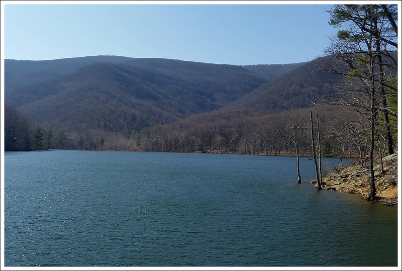
Adam at the Falls. Below: The beautiful Moormans River; Sugar Hollow Reservoir; Lunch stop after the hike.
Adam Says…
For people that are looking for a nice family-friendly waterfall near Charlottesville, look no further than this hike. In fact, it was rare to not see groups of people that weren’t hiking as a family. Most of the families with smaller children tended to stop along the river at some of the crossings to eat a snack or try and skip stones. And I can’t think of any hike that I’ve been on where I have as many dogs on a trail. So, if you want to take Fido for a walk (and a possible dip in the river) near Charlottesville, this would be a great spot as long as your dog is friendly with other dogs. We saw a couple of dogs that were running full speed chasing each other and crashing into the water. The park requires all dogs to be leashed, but we saw many (most!) people breaking this rule.
When we arrived at the trailhead, there were a ton of other cars here. There are two parking lots on this hike – the first being the larger lot and the second being a half-mile further up a rough road, but I would recommend having a four-wheel drive due to the uneven ground (even though we did see a convertible BMW driving on here with reckless abandon). The first, main parking lot was full, so we ended up parking along the roadside just a short distance prior to the first large parking lot. From the parking lot, there are two trails. You want to take the one that continues up the gravel road heading north (North Fork Trail). Walking up the gravel road, we came to the second parking area at .5 miles. There is a large closed gate directly behind the lot where the trail continues.
Christine rock hops across the stream. Below: The river was beautiful and clear; Adam checks out the rock wall at one of the crossings; Rapids from above.
Most of the trail gives you nice views of the Moormans River as you are walking by. In .75 miles, you reach your first of four river crossings. There had been a recent, heavy rain so we were expecting these to be a little challenging. The first three of the rock crossings were fairly easy to rockhop across. The fourth crossing however required us to get our feet wet in the fast-flowing current. We brought our crocs to change into for just this occasion and the cold water was refreshing. It always makes us a little nervous carrying camera equipment though when the water is moving fast and you are not 100% sure of how deep the water is or if the rock you are putting your foot on is stable. The water ended up halfway up my calf at one point, so if there has been a lot of rain, be careful.
At the 2.0 mile marker, the trail starts to gain some elevation. At 2.15 miles, we took the side trail to Big Branch Falls. You arrive at the lower falls fairly quickly, but continue further and you will see the larger Big Branch Falls at 2.25 miles. Because of the recent rains, the water was flowing nicely over the top, but probably during the dry summer months, this would be less impressive. After we took some time to enjoy the falls, we headed back the way we came to get back to our car at 4.5 miles.
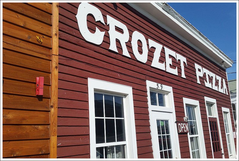
After our trip, we headed to nearby Crozet, VA to try Crozet Pizza. We had heard about how wonderful their pizza was for about 25 years now and I’m glad to say that we finally got to try it. Then, we stopped right down the road at Starr Hill brewery to sample a few post-hike beers.
Christine Says…
What a beautiful March day we had to hike Moormans River! It was the first day in a long time that actually felt warm. Early wildflowers were starting to bloom and the sunshine felt great. We started out pretty early, but found the parking lot already completely full at the trailhead. We had to find a place alongside the gravel road with enough room to park our car. After we were situated, I started MapMyHike, grabbed my camera, and started hiking.
I pointed my camera up to take a shot of the first trail marker, and the camera wouldn’t even turn on! Hmm… I had recently charged the battery, so it didn’t really make sense. I pulled out the battery and memory card to reset everything, and still no power. I figured that I had finally killed my Canon Rebel T2i. That camera has accompanied me on countless hikes. It’s been rained on, bumped against rocks, left sitting out overnight in the damp. I’m not careful with it at all, because I find I just don’t take photos when my camera is safely packed away in its padded, waterproof bag. I knew it would eventually meet this end. So… today, you get photography from my cell phone! Honestly, my phone takes decent photos – just not quite as nice as my dSLR. (Fortunately, when I got home, I found that the battery was drained after all. I guess I stored it accidentally with the power button depressed. The Rebel lives to fight another day!)
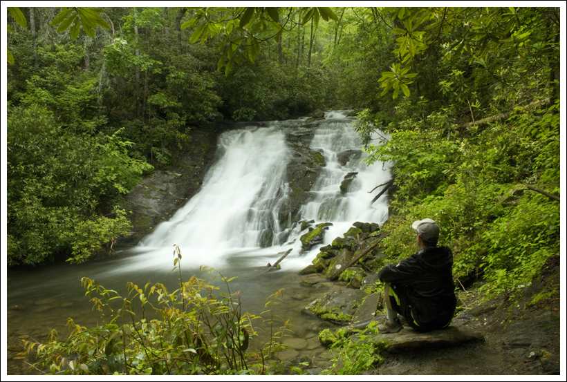
The lower falls are really pretty. Below: A view of the upper and lower falls; Rock hopping; One crossing was too deep to rock hop – so we waded.
The water was flowing beautifully and we really enjoyed the sights and sounds of running water all through our hike. The trail was one of the easiest we’ve hiked in a long time. It’s relatively level and not too rocky. The stream crossings were all moderate to easy, with the exception of the final one. The last crossing required us to put on water shoes and wade across. We saw several people attempt to rock hop, but they all ended up with wet boots.
When we reached the spur trail to the falls, there were several groups of people at each viewing point. We waited our turn and spent a few minutes enjoying and taking photos of the upper falls. One group had climbed up to the top of the falls and was picnicking on the rocks alongside the cascade. A man with the group walked out to the precipitous, domed edge of the falls several times. We were worried he might slip and have a nasty fall to the rocks below. Thankfully that didn’t happen!
On our way back down, we scrambled off the trail to a rock shelf beneath the lower falls. On the climb back up, I stuck my trekking pole in a hidden hole. When the pole suddenly dropped and vanished under the weight of me climbing up, I slipped and smashed the bridge of my nose into the trekking pole handle. Wow – did that hurt! I thought I hit hard enough to break the skin open, but thankfully it was just swollen and lightly bruised. Between that and the broken camera, it was not one of my luckier days on the trail!
The dam and reservoir. Below: Yum – Crozet Pizza; Flight at Starr Hill.
The hike back went very quickly. After we got back to the car, we made our way to a great lunch at Crozet Pizza and a flight of beers at Starr Hill. It was a fun day! I would definitely recommend this hike when there has been significant, recent rain. The falls dry up pretty quickly.
Difficulty – 2. The hike is not difficult with the distance and elevation, but the stream crossings could be a challenge.
Trail Conditions – 4. The trail is heavily-used and well-maintained.
Views – 1.5. You do get some elevated views of the river. Views from the top of the dam (after the hike) are really nice too, but don’t count in the score because they’re not technically part of the hike!
Streams/Waterfalls – 4. The waterfalls are nice to see (but could be disappointing in dryer months), but the highlight is probably walking along Moormans River.
Wildlife – 0. Due to the location and popularity, I wouldn’t expect to see much.
Ease to Navigate – 4. Once we knew where to go from the parking lot, it was easy to navigate.
Solitude – 1.5. I would expect on a nice day, you should see lots of people. Go early to beat the crowds and to get parking. But, there weren’t as many people going all the way to Big Branch Falls.
Directions to trailhead: From I-64 near Charlottesville, take exit 124 for US-250W. Turn right on 250-W and go 5 miles. Take the Country Road 654/Barracks Road exit. Turn right on Barracks Road and go 2 miles. Continue on SR 601/Garth Road for 9 miles. Continue straight on to Sugar Hollow Road for 5.5 miles. When you pass the Sugar Hollow Reservoir on the left, you are getting close. The road turns into gravel and you will eventually arrive at the first large parking area. Park here and walk further up the road for .5 miles until you reach the second parking area and closed gate.
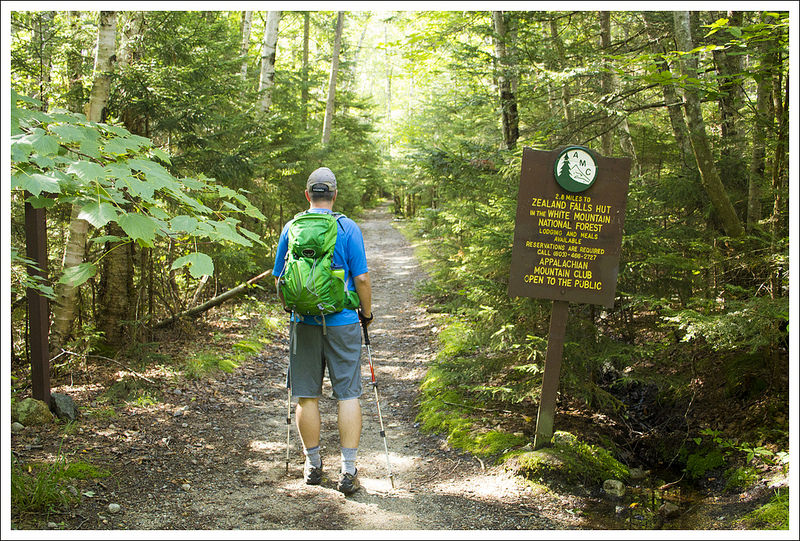
This 5.6 mile route to Zealand Falls is one of the easiest hikes we’ve done in New Hampshire. Most of the footing is smooth, soft, and flat! It was a real treat after climbing Pierce and Madison.
Adam sits at the top of Zealand Falls and takes in the view of mountains beyond and wetlands below. Below: Zealand Falls Hut is a popular hut for people who want to stay at an AMC Hut, but don’t want a tough hike; Christine hikes along; While the trail was generally flat and smooth, there were occasional roots and rocks to negotiate.
Christine Says…
The hike to Zealand Falls is doubtlessly the easiest ‘hut hike’ in the White Mountains. The elevation gain is barely discernible until the last couple tenths of a mile. The route offers mountain views, waterfalls, stream scenery, and lovely ponds. Guidebooks say it’s a great place to bird-watch and spot a moose (though I have my doubts about the actual likelihood of seeing a moose!)
The hike starts out at a parking area at the end of Zealand Road. It’s a fee area, so make sure you bring cash to pay at the self-service parking station.
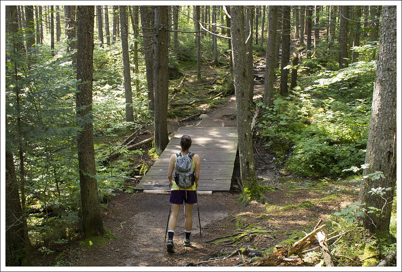
We made our way along the trail, marveling at how smooth and soft the footing felt. There were certainly some spots with roots and rocks, but generally the trail was level and covered with a bed of pine needles. We could hear the Zealand River, but didn’t reach a close view of the water until .8 miles into the hike. When we hiked (early August), the water was low, clear and running quietly along. Almost all of the water crossings we encountered on this trail were assisted by wooden footbridges – no wading and very little rock hopping necessary!
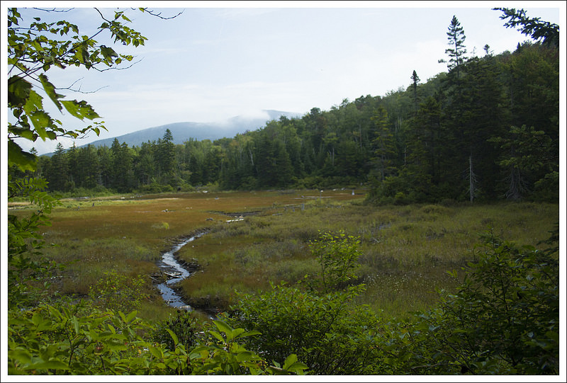
The Zealand Falls trail passes many ponds and marshes. Below: Several views of the ponds and marshes along the Zealand trail.
As we walked along, the terrain became marshier. At about 1.8 miles in we passed a lovely beaver pond. We could see the dam from the trail, but didn’t see any beavers. The reflections of trees and mountains in the water were especially beautiful! With all the wetlands, I expected biting flies, mosquitoes and gnats to be a major issue, but we didn’t have any trouble at all. Maybe there was just enough of a breeze to keep the bugs at bay.
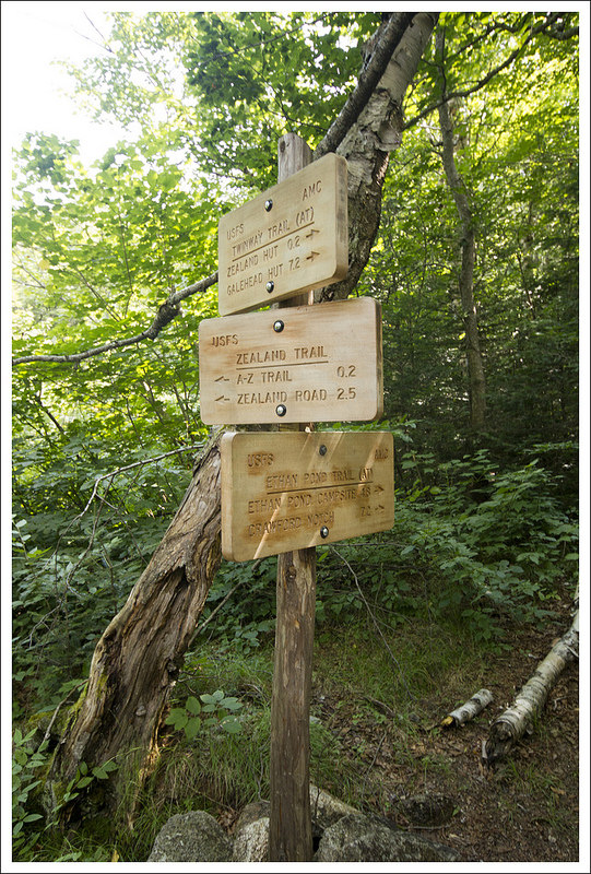
At 2.3 miles we passed the junction with the A-Z trail, where we continued on the Zealand Trail. A couple tenths of a mile later, we passed Zealand Pond and reached the junction with the Twinway (which is also the Appalachian Trail in this area) and Etlan Pond Trails. The last couple tenths of a mile to the hut follow the Twinway Trail.
Almost immediately after the junction, we reached the bottom of Zealand Falls. The water was running low, but it was still beautiful. There are two places to stop and admire the falls on the way up. The first stop is a view of the gradual, slide-like lower falls. The view of the upper falls is a bit more dramatic. The rocks around the falls are blocky and reddish-orange in color. The water comes plunging steeply over a cliff-side. The last tenth of a mile up to the hut is steep and rocky – honestly, it’s the only challenging part of the hike.
Zealand Falls make a couple distinct drops. Below: New signs were recently posted to mark trails in the area; Adam checks out the falls; The final ascent to the hut was the only steep part of the hike.
Zealand Falls Hut enjoys a lofty perch looking out across two notches. You can see the Bonds and Mt. Carrigain. There’s even a bench available for anyone who wants a nice seat to enjoy the view. We spent some time poking around the hut. The Croo had just made cinnamon rolls and purple frosted blueberry cake, but we weren’t quite ready for a snack. Instead, we decided to take the little side trail to the ledges of Whitewall Brook. It’s just a 25-30 foot walk through the trees. The brook passes over immense slabs of rock. It’s a nice place to sit, soak in the sun, and enjoy the view of the pond below and distant mountains beyond.
After spending some time enjoying the hut, we returned the way we came. The walk back was all downhill, so we made quick work of it. I would highly recommend Zealand Falls to anyone looking for a low-key hike without much climbing. In fact, we gave it such glowing reviews that my parents tried the hike a few weeks later. They enjoyed it and felt it was very approachable for hikers of any level.
Adam Says…
When we go about trying to cover a lot of hiking mileage on our vacation trips, we like to alternate some easier hikes with the tougher ones. Since we had just climbed Mt. Madison, our feet and joints were happy that we chose this easier leg-stretcher.
Christine and I do like to hike with goals in mind. Since we have climbed a few of the 4000-footers in New Hampshire (there are 48), we have thought about possibly trying to bag all of those peaks. Last year on our visit, I picked up AMC’s Passport to AMC’s High Huts in the White Mountains. That book describes each of AMC’s huts through the White Mountains and details the history, features, and interesting stories about each of the huts. It also serves as a passport that you can have stamped at each location to mark that you have been there (you can even earn a patch when you’ve visited them all). This was definitely enough of an incentive to try and reach all the huts.
Zealand Falls Hut sits at the top of a waterfall. A short trail from the side of the hut leads to the streambed; Inside the hut; View from the hut; Christine at the top of the falls.
As Christine mentioned, this trail had nice footing compared to what we were used to in the White Mountains. The trail was fairly smooth as it started through the woods mixed with pine and birch. The trail eventually opened up into some great views over marshy ponds. There was a large boardwalk to walk across that I thought would be a perfect vantage point for spotting a moose. There were such nice views over the dammed-up ponds and it reminded me that we were in a state filled with lots of lakes, ponds, and streams. We took a while to enjoy the scenery around us. The trail continued to give us lots of similar views and short step-offs to pond views. The trail eventually goes back into the woods as you get closer to Zealand Falls Hut.
At 2.3 miles, we reached the junction with the A-Z trail, which I came to realize after looking at our map that it connects the Avalon and Zealand trail, hence the A-Z name. At 2.5 miles, we reached a short side trail to check out Zealand Falls. The falls here were a nice place to get sidetracked. We crossed a few rocks and enjoyed climbing around the rocks at the base of the falls. Looking up towards the top of the fall is where this hike ends, but you should stick to the trail rather than trying to climb up the falls.
We continued our last piece of the hike, which was a steep and rocky .2 miles until we reached the Zealand Falls Hut at 2.8 miles. There were a few day-hikers at the hut, recounting tales of all the places they had visited around the world. We decided to take the short trail from the hut to the streambed of Whitewall Brook, which is the top of the falls we had seen below. Christine got a lot of pictures while I walked around climbing on some of the rocks and collecting a few blueberries from the nearby bushes. We then found a picturesque spot on the large rocks to take in the view of mountains ahead and the waterways below.
The woods along the trail were so beautiful! Below: Adam rock hops; Beautiful, tall, straight trees; A beaver dam.
We stopped back in to the hut to talk to the Croo members who were cleaning up breakfast and starting to prepare some food for lunch. I know they have some busy days, preparing meals, cleaning the hut, and transporting supplies on their backs to and from the hut. I talked to one of the members about how this hut was so much easier to reach than most of the others we had seen. I wondered if there was a selection process that was made to match up Croo members to the huts or if they even had a choice. It seems like maintaining this hut and transporting supplies would be made for those that wanted or needed an easier experience. We made our way back to our car the same way we came up.
I would recommend this hike to anyone that would like to see what one of the AMC huts looks like. It is the easiest one to reach, so people of most abilities should be able to attain the top. This is one I could see us doing many times in the future due to the ease and the serenity that the scenery of the marshes and waterfall evokes.
Difficulty – 2. This is a pleasant, easy walk until the last couple tenths of a mile. The last push to hut is short but steep.
Trail Conditions – 4. The trail is so nicely built and easy to walk. Most of the water crossings and marshy areas are traversed by sturdy bridges and boardwalks.
Views –3.5. Views from the hut and Whitewall Brook are nice, as are several views across the wetlands, but generally the views here are less dramatic than other spots in the White Mountains.
Waterfalls/streams – 4.5. The river, pond, wetlands, brook and waterfalls are all lovely!
Wildlife – 3. It’s supposed to be a nice area to spot wildlife, but we just saw birds and squirrels.
Ease to Navigate – 4. Trail junctions are clearly marked and easy to follow.
Solitude– 3. We saw relatively few people, but we hiked on a weekday in August. I think this is generally a popular trail.
Directions to trailhead: From I-93: Take Exit 35 for Twin Mountain. Follow 3N for 10.4 miles. Turn right onto 302E for 2.2 miles. Turn right onto Zealand Rd. and drive about four miles. The road will turn to gravel. The parking area is at the dead end of the road. There is a $3/day fee to park at the trailhead.
* MapMyHike is not necessarily accurate, as the GPS signal fades in and out – but it still provides some fun and interesting information.
This wonderful little network of trails gives you the opportunity to view Linville Falls from every angle! You can choose short/easy routes or longer/harder routes depending what you’re in the mood to do. When all was said and done, we hiked a little over 3.5 miles and enjoyed several views of the falls.
Adam enjoys a bird’s eye view of Linville Falls. Below: The forest service information station; the trail network offers many options; beautiful blooming rhododendron.
Adam Says…
To finish our trip to North Carolina, we had to visit Linville Falls along the Blue Ridge Parkway. While overcast days are better days for photographing waterfalls, we had to take what we were given. The sun was high in the sky and it was quite hot on the hike, but we knew this wasn’t going to be too long of a hike.
We drove up the gravel Wiseman’s View Road and went first to the USFS Visitor’s Center. Two women were inside and gave us some information on how to tackle the falls. We were looking for a place to eat lunch before the hike and they recommended Famous Louise’s Rock House, especially for their pies. We took their advice and refueled for the hike. We ventured back up Wiseman’s View Road and parked in the large gravel lot at the to the left of the road. The trail starts from the eastern side of the lot and begins with a steep descent.
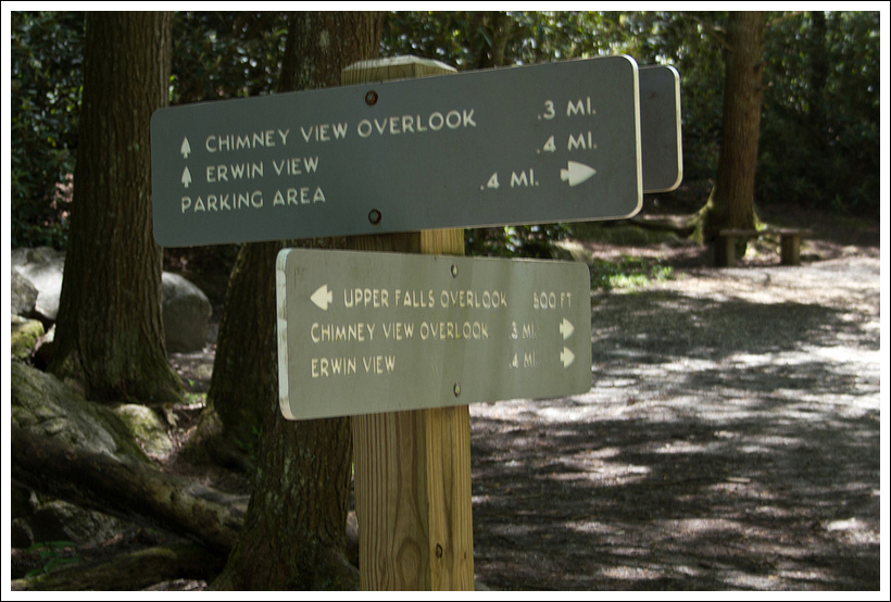
At about .2 miles of a descent, we reached a junction. We took a right here to make our way to the series of overlooks of the falls. In a short distance, we reached another smaller junction with the trail to the Upper Falls, but we decided to approach that on the way back. Since there are so many choices to make about the order in which you take in the views, I will not list all the distances; but you can tell from the downloaded map the distances to each. We opted first to take a left for the trail to Chimney View, which provided a viewpoint to see the upper and lower falls. From this point, we backtracked to the main trail and took a left. Shortly, we came on to the side trail on the right for the Gorge View. The views from here showed the canyon of the gorge but the views didn’t allow you to see the bottom of the canyon. Next was the end of the main trail, which ended at Erwins View. This view gave you the furthest view away from the falls, but it was still spectacular. We backtracked and made our way back to the Upper Falls viewpoint. From here, you could see the water plunge down the falls from a closer distance.
The upper falls view. Below: A view into the gorge; Adam hikes along.
From seeing people on the opposite side of the water and very close to the falls, we decided to take the trail down to the Linville Falls Visitor Center. The trail was wide, road-like and going slightly downhill. We eventually came to a bridge over the Linville River and the Visitor Center was on the opposite side. We grabbed a few cold waters from the center and talked to the rangers about the trails on the other side. We were fairly tired by this point, since we had done so much hiking during the week, but the temptation of the falls kept us pressing forward. From the front of the Visitor Center, the trail headed into the woods on the eastern side of the building. In a few feet, the trail branched and we took a right to head to the next overlook. This trail branched off after about .3 miles. We took a right at the junction, descending to reach the Plunge Basin overlook at .5 miles. This point gave you a vantage point to see the water shoot through the gorge and down below. We watched one man standing on the cliffside below, fishing from a precarious position. We then made our way back to our car by returning to the Visitor Center, back across the bridge, and taking a right to the trail junction that led us back to our vehicle.
We had a great time visiting Linville Falls and this is definitely a hike that most people could do with their families. A return trip in the peak of fall color with an overcast sky is something we will try to do. While many waterfalls allow you to get very close to them, the trails here mostly keep you at a distance. However, the view of the gorge with the waterfalls is breathtaking.
Christine Says…
Linville Falls was a perfect hike to end our trip through Tennessee and North Carolina – short and very easy! Ten hikes packed into eight days was pretty rigorous and I had the sore knees, bruises and sunburned arms to show for it! Truth be told, I was secretly pleased that the ninth day of our voyage was stormy and rainy, because it meant we’d go home a day early instead of biking the 33+ miles of the Virginia Creeper. Don’t get me wrong – I LOVE biking the Creeper, but I was exhausted from our whirlwind trip. Maybe we ought to relax more on vacations – like normal people! Nah…. probably not. 🙂
Linville Falls were a gift to the National Park Service from John D. Rockefeller. So many of our favorite parks would not have existed without his generosity. Acadia, Shenandoah, Yosemite, the Grand Tetons, and the Smokies were all established, in part, due to his financial support.
The plunge view of the falls. Below: The Linville River; Beautiful desserts from Storie Street Grille.
Adam did a thorough job describing all the different paths we took, so I don’t have a lot of details to add about the terrain. The only thing I would say is that you can walk to the bottom of the falls. It’s about about .8 miles of hiking (some steep). We opted to skip the view from the bottom on this trip, mainly because we were tired and could tell that the base of the falls was extremely crowded.
I enjoyed stopping in the visitors center and talking to the park ranger. He was a pretty serious hiker and we enjoyed trading trail tips. He suggested Crabtree Falls, NC for a future hike. I was also fascinated by the cross section of an enormous tree hanging in the center. It fell when the Linville Gorge flooded in September of 2004. The hurricane-related flooding was so severe, that it washed away half of the visitor’s center and left many gigantic, toppled trees in its wake. Water is such a powerful force!
Linville Falls has one of the highest water volumes of any waterfall in the Blue Ridge, so it’s not surprising that it floods so easily. The high volume of water also makes the gorge perilous for people. Swimming is not allowed in the river near the falls, but numerous fatalities have still occurred in the area.
After finishing our hiking for the day, we retreated back to our cabin at the Pineola so we could get showered and dressed for dinner. We decided to go fancy for our last evening in the area, and enjoyed a fabulous dinner at the Storie Street Grille in Blowing Rock, NC. In addition to lovely outdoor patio seating, hey had a great wine line, beautifully prepared entrees, and amazing desserts. Even though I’d already had pie a la mode earlier in the day, I could not pass up their dark chocolate – coconut bread pudding. Adam’s banana creme brulee was equally delicious. It was a fitting end to a fabulous trip!
Our next post will actually be a Virginia hike – shocking! But then we’ll be going back to some more out-of-state posts. We’re headed for the White Mountains of New Hampshire in a couple weeks, and are hoping to bring back at least a couple posts from that area. Stay tuned!
Difficulty – 1. The trail does have a little climbing up and down on the trail, but most people should be able to do it without too much trouble. We saw people of all ages and all levels of fitness on the trail, so it should be doable by anyone willing. The options for different viewpoints allow for people to choose what they can handle and decide when to stop.
Trail Conditions – 4.5. Most of the trail is either gravel or dirt and is well-worn.
Views – 4. Great views of the gorge and waterfalls.
Streams/Waterfalls – 5. There are many viewpoints to see the waterfalls. The only challenge will be to enjoy it with few others around.
Wildlife – 1. You may see squirrels and some birds flying around, but it would be unlikely to see much else.
Ease to Navigate – 4. There is a large branching of side trails here, but using the map should guide you along.
Solitude – 0. With such a close proximity to the Blue Ridge Parkway along with the ease of difficulty, this hike is crowded.
Directions to trailhead: From US 221, turn on to NC 183. In .7 miles, turn right on to Wisemans View Road at the large curve. The parking lot is a short distance on the left and the trail starts from the eastern side of the parking lot.
* MapMyHike is not necessarily accurate, as the GPS signal fades in and out – but it still provides some fun and interesting information.
The 4-mile Kephart Prong hike ascends gently along a beautiful stream and end at the backcountry campsite – Kephart Shelter. This hike offers lovely cascades, wildflowers and history.
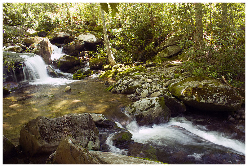
Adam crosses one of several log bridges over Kephart Prong. Below: The trailhead is located on the side of Rt.441. The first bridge takes you across the Oconaluftee River; The Oconaluftee is beautiful and cascading; So much of the Smokies seems to be wet, green and covered with moss.
Christine Says…
Our second day in the Smokies was earmarked for a hike to the summit of Mount LeConte, but we woke to gloomy weather. We decided that we didn’t want to hike ten tough miles and not even get payoffs in terms of views, so we devised a new plan! After redoing our Deep Creek Waterfall Loop Hike to get better photos, we were still ready for more hiking.
I perused our hiking guide and found a trail called Kephart Prong. It sounded interesting – remnants of an old railroad and a CCC camp, a backcountry camping shelter and the trail followed a (possibly pretty) stream. After redoing the earlier hike, the 4-mile length of the Kephart Prong was appealing, too – short and sweet! Also, it had the benefit of being closer to the Bryson City side of the park where we were staying for the early part of our trip.
It was still morning, so we grabbed a snack and made our way to the trail. What we found exceeded my expectations. The stream was incredibly beautiful – rapids and small waterfalls tumbling over mossy rocks and fallen hemlocks. In at least four places, rough, hewn log bridges traversed the stream. The sounds of running water carried through the entire hike. We saw lots of wildflowers – pink lady slippers, wild geranium, ragwort and many others I couldn’t name.
There were many kinds of wildflowers along the trail. This might be a wild geranium? Below: Adam explores the ruins of the old CCC camp in the area. This chimney was supposedly located in the barracks; There was once a railroad and a trout hatchery in this part of the Smokies, so look for abandoned rails, train parts and pipes from the hatchery. The item below appears to be an old pipe joint possibly; Another beautiful, mossy, log bridge over the stream.
The hike climbed gently the entire two miles until eventually arriving at the Kephart shelter – a sturdy stone and timber hut intended for backcountry camping. We chatted with other dayhikers using the hut for a lunch stop and one man who was there for an overnight stay.
Signs near the shelter showed that the Kephart Trail connects to the Sweat Heifer and Appalachian Trails. If we had continued to climb past the shelter, we would have arrived at Charlie’s Bunion in several miles.
Despite the draw of the Bunion, lunch was a higher calling, so we made our way back down the trail. It’s amazing how much faster the climb down always goes! We got back to the car around 1:00 and were back in Cherokee by 1:30. We couldn’t find anything that sounded good and was actually open on Sunday, so we pressed on back to Bryson City and ended up at a place we found on Yelp – The Bar-B-Que Wagon. They served great, traditional Carolina style pit barbecue with all the expected sides. We sat at a picnic table by the river and enjoyed an enormous, late lunch.
After lunch, we thought about going back to the hotel to shower, but instead we pushed on to visit the NOC (Nantahala Outdoor Center). The complex has a fantastic outdoor outfitter and a super cool riverside patio bar (Big Wesser BBQ + Brew). We got a few drinks and watched rafters and kayakers working the rapids. So relaxing! What a great day!
Adam Says…
The Kephart Prong Trail is one of the most definitive picturesque, riverside trails you’ll find. The lush forests surround you in a sea of green in every direction you turn.
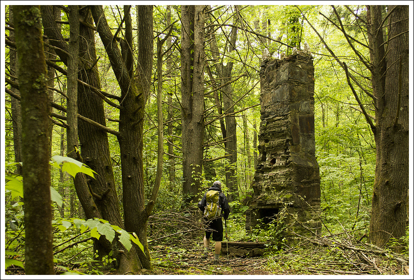
The trail starts off by crossing a large bridge, giving you great views of the Oconaluftee River. Once you cross the bridge, the trail starts off as wide and gravel-covered. At .2 miles, you will come across the remnants of the Civilian Conservation Corps camp that was here from 1933-1942. You’ll see signs of a stone plaque and a tall chimney, among other partial walls.
At the .5 mile mark, you’ll reach your first footbridge over the stream. As you continue further, the trail continues a slow, gradual ascent to the end. You’ll cross three other footbridges, but these consist of narrow, split logs with wood handrails. The last of these was the only one I was a little concerned with crossing, since the handrail required you to stoop to be able to touch it and the log bounced some in the middle. The trail leads to the Kephart shelter, which was well-constructed. From the shelter, you can proceed on the Sweet Heifer Creek Trail which joins the Appalachian Trail in 3.7 miles or take the Grassy Branch Trail to the Sluice Gap Trail for a total of 3.8 miles to reach Charlies Bunion. Since this is a nice junction for an overnight trip, expect other people staying at the shelter in the nice summer-fall weekends. Backcountry reservations for overnight campers is $4/night and is required to be made in advance. See here for further regulations regarding backpacking permits.
Kephart Shelter sits under the shady evergreens. You must have a permit to stay the night in this shelter. The stream runs behind/left of the shelter. There used to be a logging camp where the shelter now stands. Below: Most of the trail follows the stream closely; Adam makes his way across the bridge; A trail sign near the shelter shows the directions to other trails higher up the mountain.
The Kephart Prong is named after Horace Kephart, who was instrumental in the establishment of the Great Smoky Mountains National Park. He was an extremely intelligent man, enrolling in graduate school at Cornell University at the age of 17. He became the head of the St. Louis Mercantile Libray, but he lost his job. He had turned to drinking and his wife and family left him for New York. He decided he wanted to re-establish himself in the wilderness of western North Carolina and Tennessee. There he wrote the book Camping and Wildlife, which was considered the “bible” of camping. When he became concerned that the Smoky Mountains were going to be heavily logged, he started writing letters to advocate for the establishment of this area as a national park. He soon became friends with a photographer, George Masa and together they started photographing and mapping this area. It was the partnering of Kephart’s words with Masa’s pictures that caught John D. Rockefeller Jr.’s attention, who donated $5 million to help purchase the lands to help secure the area to become a park. Kephart died in a car crash before the park was to be established, but Mount Collins was renamed Mount Kephart in his honor.
Big Wesser BBQ + Brew at the Nantahala Outdoor Center is a great place to enjoy drinks after a day on the trails. You can see the canoe/kayak course gates in the river. It’s fun to watch people coming down the rapids. Below: Carolina-style BBQ in Bryson City.
Another interesting spot almost immediately on the trail are the remnants of the site of the Civilian Conservation Corps (CCC) camp 411 here. You can see the large chimney and camp signboard on the side of the trail. This group of nearly 200 built rock walls, roads, trails, and footbridges that are still in use today. There is an interesting history of this from one of the leaders, James William Biggs.
We enjoyed this beautiful trail and I can see incorporating this trail as part of a backpacking trip in the future.
Difficulty – 1.5. The ascent on this hike is very gradual and easy.
Trail Conditions – 4. The trail is well-graded and in great condition.
Views – 0. No scenic views.
Streams/Waterfalls – 5. Very beautiful!
Wildlife – 2. We didn’t see anything other than chipmunks and squirrels.
Ease to Navigate – 4. The trail is very easy to follow to the shelter. Once you reach the Kephart Shelter, you may decide to continue on.
Solitude – 2. Because of the relatively short length and easiness of this hike, you will probably see a fair number of people.
Directions to trailhead: Head north on US-441 N from Cherokee, NC. Head 4 miles north of the Smokemont Campground. Parking is available on the shoulder of the road and the trail starts after crossing the bridge over the Oconaluftee River.
* MapMyHike is not necessarily accurate, as the GPS signal fades in and out – but it still provides some fun and interesting information.
Deep Creek is an area of the Smokies popular with tubers, bikers, horseback riders and hikers. This (roughly) 5.4 mile hiking route provides spectacular views of three waterfalls and the beautiful streams that feed them. We ended up hiking this trail twice on our trip – the second time was mostly to get better photos. 🙂
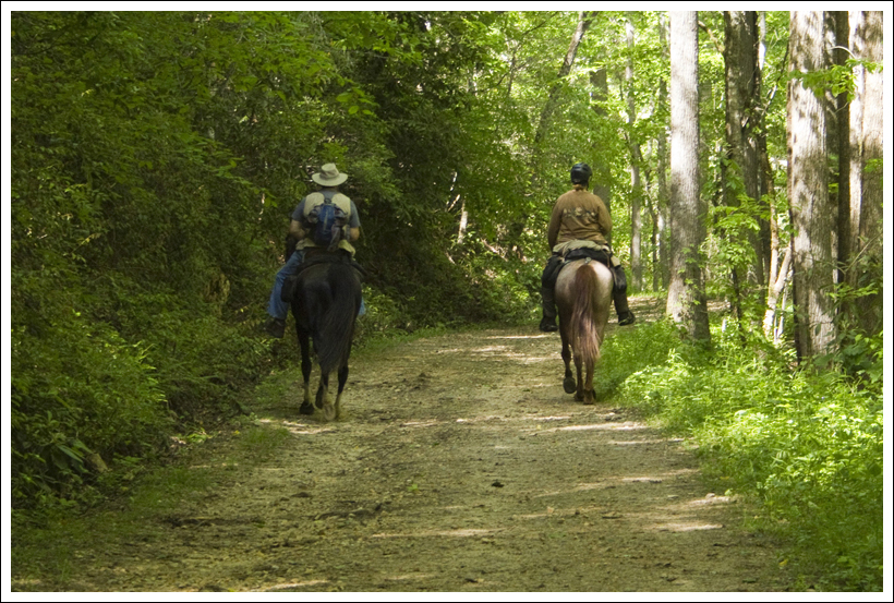
Toms Branch Falls is the first waterfall you’ll come to on the loop. It’s only about a quarter mile from the parking area. Below: Another angle of Toms Branch Falls; Horseback riders love the Deep Creek area; Tubers on Deep Creek; Christine enjoys stream scenery.
Adam Says…
We rolled into Bryson City, NC around 2:15 and almost immediately headed out for a hike. We were tired but our hotel wouldn’t let us check in even 45 minutes early. Evidently, the Microtel in Bryson City is very strict with their policies! We decided to do something close by, so we headed to Deep Creek campground for this hike with three waterfalls.
We knew we were getting close to the campground when we saw tons of “TUBES” signs. People were waving as we drove by, hoping that we would stop and rent tubes from them for floating down the river.
We arrived and got changed in the parking lot and made our way to the trailhead. The parking lot was crowded, mainly for tubing people. We followed the masses heading out carrying their inner tubes to their drop-in spots.
We started on the Deep Creek trail and soon passed the junction with the Juney Whank trail on the left. In just about .25 miles, we came across the first waterfall on the right, Toms Branch falls. This is a gorgeous waterfall that drops about 60 feet over several different rock shelves before plummeting into Deep Creek. We saw several people floating down the creek as we stopped for some photographs.
Adam enjoys beautiful Indian Creek Falls. Below: We spotted pink lady’s slippers along the trail. They were a little tattered at the end of their blooming season; Adam climbs the trail.
At .75 miles, we reached the junction with the Indian Creek Trail. This is actually the last spot where people can drop their tubes into the creek, but we continued on the Deep Creek trail. At 1.75 miles, this trail intersects with the Loop Trail. We took a right on to the Loop Trail which starts a steep ascent. At 2.4 miles, the trail reaches its peak and intersects with the Sunkota Ridge Trail. Continue on the Loop Trail which now descends at about the same rate as it ascended. At 3.0 miles, you reach the junction with the Indian Creek Trail. Take a right here.
At 3.8 miles, you’ll see a side trail that descends to Indian Creek Falls. Indian Creek Falls is a wide waterfall that has a gradual, sliding cascade into the water. After taking in the sight, head back to the trail and continue to the right. Shortly after passing the waterfall, you will reach the junction again with the Deep Creek Trail. Take a left here to retrace your steps. You could make this a shorter trip by initially taking a right at the junction, but we enjoyed putting a little extra effort to earn all three waterfalls.
Right before you reach the parking lot, you’ll see the junction trail again with the Juney Whank trail at 4.5 miles. Take the steep trail to the right up for .3 miles. Once you reach the top, you’ll see Asian which points you to the next waterfall. Descend down a short path and you’ll reach a footbridge and the waterfall. Juney Whank Falls is another great waterfall that plunges down after about a 80 foot cascade.
Continue to the other side of the footbridge and continue on the trail, heading left at the first junction. The trail descends rather steeply. You’ll see signs that lead you to the parking lot and back to your car.
The streams in the Smokies are so beautiful! Below: Since the trail is popular with horseback riders, there is a lot of manure along the way. Butterflies apparently love manure!; Beautiful Deep Creek; Adam on the loop portion of the trail.
We had a great time on this trail that maximizes your waterfall experience. The Deep Creek Trail and Indian Creek Trail both gave you great creek views almost the entire walk and it was fun to watch everyone float by us. I can see why this is such a popular place to hike and tube for families. We saw one person with a foot cast and met one woman with a pacemaker along the way, so most people should be able to handle this. If you want to see some great Smokies waterfalls, this is a hike for you!
Christine Says…
We wanted to do this hike last year when we visited Bryson City, but with so much to do in the Smokies, we just ran out of time. This year, we knew the lay of the land a bit better, and we ready to hit the ground running (or hiking, so to speak!)
We arrived to the area mid-afternoon on the Saturday of Memorial Day weekend. We tried to get into our hotel one before official check-in, but the desk clerk turned us away. We decided to drive over to the Deep Creek Campground, and check out an easy loop hike that took us by a couple waterfalls – Toms Branch Falls and Indian Creek Falls.
I changed clothes in the crowded parking lot. Let me tell you… switching from jeans and a shirt into shorts, wicking shirt and sports bra without flashing anyone is quite a feat!
We started off along a wide, road-like trail that followed parallel to Indian Creek. It was packed with people out enjoying the warm, sunny weather. Apparently, the Smokies have had an exceedingly cold and wet spring, so the bright, 80-degree Memorial Day weekend was a great chance for everyone in eastern Tennessee to go outside. Deep Creek is very popular with tubers. All up and down the road leading to the campground, various vendors have set up shop renting tubes for roughly $5 a day. Once you have a tube, you walk about a mile up the trail, and then bob and bump along the shallow, but rapid-y river. It looks like a lot of fun! As hikers, we were in the definite minority.
Juney Whank may be the prettiest waterfall on the loop. Below: Adam enjoys the falls from the bridge; Juney Whank is beautiful from every angle; Below the falls.
Walking along the Deep Creek Trail for about .25 miles, we came to the lovely Toms Branch Falls. It’s a tall waterfall that enters Deep Creek from the bank opposite the trail. Very impressive!
We walked along the creek until reaching a junction that makes a lollipop loop on the route. We decided to follow the longer arm of the loop so that we could visit Indian Creek Falls closer to the end of our hike. The trail mostly followed the stream before turning and climbing steadily uphill for about half a mile. At the highest point, the trail met the Sunkota Ridge Trail, which leads to higher elevations and a larger trail system. We remained on the loop and descended another half mile to meet another trail junction.
At this junction, we met a group of horseback riders. One rider was really struggling with her mule. She had dismounted because he had become so skittish. When we passed, he was bellowing and dancing around. She eventually got him under control and was able to ride on. He looked like quite a handful though!
In a few more tenths of a mile, we came upon Indian Creek Falls. These falls are not as steep, and are made up of a couple of small ‘shelf-drops’ before falling into one larger fall. Very beautiful!
About a tenth of a mile past the falls, you join back up with the beginning of the lollipop loop. From there, just follow the trail and the tubers back to the parking area.
The Nantahala Brewing Company – a good post-hike stop in Bryson City.
To be honest, I was really unhappy with my photos from this hike. Waterfalls, sunny conditions and photography simply don’t go together. So, I left this hike feeling a little disappointed with the photos I had to share. That regret quickly faded after a few beers at the Nantahala Brewing Company. What an awesome place! If you like craft beer, don’t miss a visit. After beers, we went for pizza at Anthony’s. It hit the spot and we loved our outdoor table facing the train depot.
I thought our experience with the waterfall hike was over, but the next morning we woke to gloomy, drizzly weather. Since it was such an easy hike, we went back and did it again so I could get better photos. And the second time, we added the .6 mile loop to visit Juney Whank Falls to the trip. These falls required a short, but steep climb, but may have been the prettiest of the three! And the better photos gained from a second trip around made this hike twice as nice!
Trail Notes
Distance –5.4 miles
(Check out the stats from MapMyHike)* These stats are from the first time we hiked the loop, so Juney Whank Falls are not included in the MapMyHike mileage or elevation.
Elevation Change – About 630 ft.
Difficulty – 2. The only tough parts of this hike are the steep trail on the Loop Trail and the side trail to the Juney Whank falls
Trail Conditions – 4. Most of the trail is gravel except for the Loop Trail. This is a multi-use trail and you will see hikers, bikers, and horses on this trail. The trails were in great shape with no blowdowns or rough footing.
Views – 0. No scenic views from the trail, but this is more for the waterfalls.
Streams/Waterfalls – 5. You’ll have the best stream views along Deep Creek and three gorgeous waterfalls.
Wildlife – 2. Don’t expect larger wildlife due to the crowds of people on this trail. We did hear lots of pretty warblers in the tree.
Ease to Navigate – 4. Good signage at the trail junctions for the most part except for coming off the Juney Whank falls trail.
Solitude – 1. Expect to see lots of people for most of the trail. A lot of people choose not to do the Loop Trail.
Directions to trailhead: Take exit 67 off of NC-74 towards Veterans Blvd. Go .6 miles and take a right on Main Street/NC-19. Take the second left on to Everett Street. You’ll see signs directing you to Deep Creek Campground. Go .3 miles and take a right on Depot Street. This road makes a quick left on Collins Street and then a quick right to continue on to Depot Street. This becomes Deep Creek Road. Go .3 miles and take a left on to West Deep Creek Road. Continue 2.4 miles until you enter the Great Smoky Mountains National Park – Deep Creek campground. A parking lot is on the left. The trailhead starts near the drop-off roundabout next to this parking lot.
* MapMyHike is not necessarily accurate, as the GPS signal fades in and out – but it still provides some fun and interesting information.
This six-mile loop hike in the Fridley Gap area of George Washington National Forest has everything – views, waterfalls, beautiful stream scenery, rugged climbing and great backcountry camping. It’s a perfect hike to get away from the crowds in Shenandoah National Park.
If you miss spotting the faint side trail behind one of the many backcountry campsites along this loop, you’ll miss the best view of the hike! Below: Adam crosses the stream; A small waterfall on the stream; This loop has many choices for backcountry camp sites.
Adam Says…
Last year, we made an attempt to do this Fridley Gap loop hike, but we had trouble finding one of the trails. We bushwhacked for a while, but finally gave up. This time when we returned, we had better directions and the blazes had recently been repainted on much of the loop.
From the top end of the parking lot, we started on the trail. We saw both purple and blue blazes early on, and started to worry. (Fortunately, it turned out that this was the only section of the trail that hadn’t been recently re-blazed.) Early parts of the trail traverse large rocks, and it’s sometimes tough to see exactly which way the trail goes. We saw faded red Xs painted on the surface of some of the rocks which let us know that we were going the right way. The trail is uphill but not too steep. In .2 miles, you come to a fire road. Take a right here and continue on the fire road. You will pass by some small falls and Mountain Run to the right and a large boulder slide to the left. The trail actually follows the streambed, and you will need to rock-hop to continue on. At .45 miles, you will reach another falls area and you will cross over Mountain Run until you see the trail junction cement post. This is also the point that Mountain Run and Fridley Run join. It was at this point that we failed last time trying to find the orange-blazed Massanutten South trail. Looking at the cement post as you approached it, look back around 4:00. You will see the orange blazes on the Massanutten South trail as you will cross the water again (this time it is Fridley Run) and climb up the hillside. These weren’t painted on the trees before (they look fresh now), so you should be able to find your way more easily.
Early in the hike, the trail traverses the streambed. There are plenty of rocks, so it’s fairly easy to hop from spot to spot and avoid getting your feet wet. Below: Adam climbs up the trail shortly after the parking lot; A rockslide early on the hike; Blooming redbuds.
The climb up the Massanutten South trail is quite steep and you may need to stop a few times along the way to catch your breath. This trail is also narrow and you may have to cross over a few blown-down trees, but the trail wasn’t too hard to navigate with the recent re-blazing. At 1.85 miles, you will reach a campsite area. Look closely and you will see a path that leads to a rock outcropping called Grubbs Knob Overlook. Take this path up to the overlook to get the best views along the hike. You will see the top of Grubbs Knob to the left from the overlook and views to the west. After taking in the view, go back to the campsite and continue along the Massanutten South trail. At 2.05 miles, the trail reaches its peak and then you will start to descend, as the trail takes a steep turn to the left. You will make your way back down this very narrow path and cross Fridley Run at 2.70 miles.
After crossing Fridley Run, you will begin to ascend on the trail again (turning again into a wider fire road) until you reach a rocky slide that gives you views of Fridley Gap and North Mountain at 3.25 miles. Continue to ascend as you walk around part of Third Mountain. The fire road stops ascending at 3.5 miles. The trail then descends and you reach another cement junction post at 3.84 miles. Take a left on the purple-blazed Fridley Gap trail, which follow another wide fire road. You will likely see lots of burned trees from a fire in 2010 that covered a big portion of this area. At 4.5 miles, you will reach another junction. The purple-blazed Fridley Gap trail ascends to the left and continues through the woods. Take this trail and begin a steep ascent across some switchbacks. At 4.85 miles, you will reach the top of your climb and there are a few stones that you can rest on for a few minutes if you need to catch your breath.
This small waterfall feeds one of the most popular swimming holes in the area. Below: More pretty cascades.
The trail now begins to descend very steeply. We were so glad we had our trekking poles since the rocks under the leaves were often loose and it helped to lower ourselves down the steep steps. We were also glad we did this hike this direction rather than the clockwise version of the loop. At 5.5 miles, we reached another junction with the Massanutten South trail. Take a left on the orange and purple-blazed fire road (don’t go the way that crosses the bridge) and you will reach the junction that closes the loop at 5.65 miles. Take a right here, crossing Mountain Run again and make your way back down the fire road. Be sure to catch the rocky path at 5.8 miles that leads back to the parking lot at 6 miles.
A funny moment happened along the hike. Christine had programmed her phone to use the MapMyHike app. In a recent upgrade, it now includes some vocal updates along the way, usually at the mile increments. One time, we heard the voice say “Don’t stop now. Walgreen’s is behind you.” (Walgreen’s is now advertising on MapMyHike.) While this is meant to be a word of encouragement to keep hiking strong, I was thinking of it as “Walgreen’s is chasing us.” As I sometimes do, I started thinking of a parody song to the tune of the Road Runner Show TV theme song. So for your enjoyment, here are my lyrics: “Fridley hiker, Walgreen’s is after you. Fridley hiker, if he catches you, you’re through. That Walgreen’s is really a crazy store. They have pharmaceuticals, toiletries, and so much more. Fridley hiker, never, never, never slow down. Fridley hiker. Walgreen’s is after you. Fridley hiker. If he catches you, you’re through.”
There is one geocache along the trail, Fridley’s Cache, a normal-sized cache near the swimming hole.
It is always a good feeling to know that we redeemed ourselves by covering a hike that we had previously failed to navigate. If you are looking for good views of streams or a swimming hole, along with a challenging hike to get some views, this may be a great hike to try out some time.
The rocks at Grubbs Overlook might trick people into thinking there isn’t an open view. Below: Views from Grubbs Overlook and the campsite that sits adjacent to the overlook.
Christine Says…
Hallelujah for freshly painted blazes! I was so frustrated last year when our attempt to hike the Fridley Gap Loop ended in failure. The failure was mostly my fault. I tried to map out the hike based on a course I saw on someone’s Runkeeper page. There were no directions, just the route overlaid on a rudimentary map of the area. I thought we’d be able to figure things out on our own with a NatGeo map of the area. It turns out that faded blazes and a large group of people camping in the middle of the trail are insurmountable challenges to my ability to navigate. We’ll let bygones be bygones and get on to the successful version of our Fridley Gap hike.
Let me start by saying, I loved this hike! It was even better than I expected. The stream was running beautifully, the views of the valley ‘greening up’ below were lovely and the weather was perfect (sunny, cool and breezy enough to keep the bugs away). I really enjoyed the little rock-hop as the trail followed the stream bed. The small waterfall and swimming hole were so pretty.
The climb up the Massanutten South trail to Grubbs Knob was steep enough to be challenging, but not so steep that we had to stop for a breather. On the way up, we could see all the little signs of spring creeping back into the forest – tiny buds on trees, tightly curled ferns and the occasional early season wildflower poking up through the leaves. The overlook at Grubbs Knob is rather easy to miss. It lies at the top of a faint footpath above a campsite. When you first climb to the top of the footpath, vertical, spine-like plates of rock obstruct any possibility for a view. But if you climb along the rocks, eventually you come to a few footholds that allow you to scramble to the top of the rocks. Once you’re there, the valley below spreads out as far as the eye can see – farms dotted with red barns; small country towns; and wide, green fields make up most of the vista.
The climb downhill after Grubbs Knob takes you through dense mountain laurel. The harsh light makes for an ugly photo… but you get the idea. Below: Adam approaches the stream; Crossing Fridley Run.
After leaving the Grubbs Overlook, we ascended a few more moments before taking a sharp downhill turn. The trail passed through dense mountain laurel, with occasional peeks toward the next ridgeline. Eventually, we heard the sound of water again. For a short way, the trail followed Fridley Run. But soon, we had to cross the stream and head back uphill along a wide fire road. From the fire road, we caught our second open viewpoint of the hike. It was a nice view, but nowhere nearly as lovely as the one from Grubbs Overlook. It’s one thing to slog uphill and come to a magnificent rocky outcropping with a sweeping vista to appreciate. It’s a little less stirring to stop along a roadside and take in a view of a couple mountain ridges.
Eventually, the fire road met up at a four-way trail junction. One direction headed toward the Boones Run shelter, another toward Cub Run Road, another continued along the Fridley Gap trail in the direction of Martins Bottom, and of course the fourth headed back in the direction from which we arrived. Seeing this junction made me think of all the different ways these trails cross and connect. There are definitely multiple possibilities for overnight backpacking loops in this area.
The second overlooks comes at a spot along the fire road. Below: Adam checks out the map at this four-way trail junction; Continuing along the fire road before our climb up Third Mountain; Charred trees from the 2010 fire.
We followed the fire road to another junction. Heading straight would have taken us toward Martins Bottom, but to stay on course we turned left and started very steeply uphill along the purple-blazed Fridley Gap trail. By this point of the hike, I was pretty hungry and my energy was starting to flag. If I were smarter, I would have eaten a snack before tackling the climb. But I’m not smart, so I spent most of the climb complaining that I was hungry!
After a short break (and snack) atop the tree-covered peak of Third Mountain, we began a crazy-steep descent. For three-quarters of a mile, we carefully picked our way down the craggy, leaf covered mountainside. Through the trees, we could see some really fascinating rock formations on the shoulder of the next mountain over. I kept trying to appreciate the view, but every time I did, I lost my footing a bit. This climb down definitely makes the case for paying attention and using your trekking poles.
The ascent of Third Mountain may not look steep in this photo, but it is! Below: Descending Third Mountain – you can see rock formations through the trees; A bridge not taken on the Massanutten trail; Adam once again crosses the stream we crossed early in our hike.
At the bottom of Third Mountain, we had just a short walk back to our original junction – the one where everything went wrong when we tried to hike Fridley Gap last year! I was quite pleased to see that marker again and be 100% certain that we had actually found our way successfully this time around. From the last junction, we retraced our steps through the streambed, past the rockslide and back to our car.
Difficulty – 3.5. The trail goes up and down several times.
Trail Conditions – 3. The trail had blowdowns, loose conditions, and narrowness, but there were also sections that followed a fireroad. It gets an overall average rating.
Views – 3. The views from the Grubbs Knob overlook are the best on the trail, but if you miss the path from the campsite you’ll miss the best view on the loop. The views along the path at 3.25 miles are nice, but not remarkable.
Waterfalls/streams – 4. The trail goes along (and through) Mountain Run and Fridley Run on several occasions. The small falls and swimming hole gives it a bonus.
Wildlife – 2. This may be a good hike for bird watching. We saw a peregrine falcon soaring above at the Grubbs Knob overlook and enjoyed hearing the song of the eastern towhee along the way.
Ease to Navigate – 2. If we got lost before, we have to give this a low rating. The path to start the trail from the parking lot could be better blazed and there are several turns to make.
Solitude – 4. You may see some people at the swimming hole or camping alongside the junction with Mountain Run and Fridley Run. However, we only saw one other group after this point on a nice spring weekend day.
Directions to trailhead:
From Harrisonburg, VA, head east on 33. Take a left onto VA-620 North/Indian trail Road and continue for 1.7 miles. The road will turn into Rt. 717. Go 3.4 miles and take a right on Minie Ball Ln. Go 1.1 miles. At this point, the road will turn back into Rt. 620. Go 2.7 miles and take a right, continuing on 620 for about half a mile. Take a right onto Armentrout Path. Take the first left onto Airey Ln. Parking is a lot at the end of this gravel lane. If you pass the lot, you are on private property. The directions to this trailhead are a little confusing, and we recommend putting the coordinates on the map below into your phone/GPS.
* MapMyHike is not necessarily accurate, as the GPS signal fades in and out – but it still provides some fun and interesting information.
Mount LeConte is the third highest peak in the Great Smoky Mountains National Park. This 13.4 mile hike takes you past Grotto Falls and up to LeConte Lodge.
One of the early highlights from the hike up was a walk behind Grotto Falls. Below: Christine at the trailhead; Adam starts the hike up the Trillium Gap Trail; The higher we got on the mountain, the thicker the fog became; LeConte was enshrouded in fog and rain when we arrived; We had queen-sized bunk beds in our room; Near sunset, sky conditions began to clear up.
Adam Says…
When we were first thinking about going to the Smokies, we learned that the only lodging in the park was a rustic place atop Mount LeConte. After doing some research, I found out it was very difficult to get a reservation. LeConte Lodge does reservations by a lottery system. Rooms are typically available March-November, but weather occasionally dictates a shorter season. When entering the lottery, you can submit three dates you would like to stay. Then they do a drawing to determine if you have spot. The lottery drawing happened in October (the year before our proposed stay). We were really disappointed when we didn’t get a spot for any of the three dates we requested. I kept calling daily to see if a spot had opened up. I finally asked when the deposits to hold the reservation were due. Once I got that information, I called the very next day and a spot had luckily opened up on one of the original dates we had selected. We were thrilled and got started planning the rest of our Smokies trip around our stay at LeConte.
We chose to the hike up the Trillium Gap Trail for a couple of reasons. First, it’s path that the llamas use to bring up supplies and food to LeConte Lodge. Due to the remoteness of the lodge, a team of eight pack llamas is led up the mountain three times a week (Monday, Wednesday, and Friday). They bring up supplies and clean linens and carry out used linens and other refuse. The second reason we chose Trillium Gap was the more gradual elevation gain. Mount LeConte has several different routes to hike up with the others being the Bull Head Trail, Rainbow Falls Trail, Alum Cave Trail, and The Boulevard Trail. Most people seem to choose Alum Cave – it’s the shortest route (5.5 miles) and has a bit less elevation gain (2700 ft).
We started on the trail around 8:00 a.m. We noticed the llama trailer was sitting empty in the parking lot, so we didn’t get to see them packed for the hike up. Later, when we talked with the handler, he told us he normally starts around 6:00 a.m. or sunrise – whichever comes first. We headed up the trail to try and make the lodge by lunchtime. The trail begins through thick hemlock forest. The hike continues up (and is uphill just about the entire way to the top) and at 1.3 miles, you will reach Grotto Falls. Grotto Falls is a gorgeous waterfall and the interesting thing is that you get to walk behind it as you continue along the trail. We stopped for some photos of the waterfall, but due to the early start we had it completely to ourselves. We continued past the waterfall and continued the climb. The trail becomes rockier and more narrow at this point on. The trail continues to round the mountainside. At 3.1 miles, you reach the junction with the Brushy Mountain Trail. Hang a right to stay on the Trillium Gap Trail. The trail seems to be relatively level for about .25 miles, but then begins some switchbacks that lead you up the mountain. The trail continues to climb for the rest of the hike. You will eventually come to some areas with steps through a tunnel of fir trees. At this point, you are nearing the end of your journey and will pass a horse hitch. You will finally reach the lodge at 6.7 miles.
Adam approaches Grotto Falls. Below: We saw lots of llama prints and boot prints on the trail; The damp conditions were perfect for snails – we saw so many along the hike; Adam checks out the other side of Grotto Falls; Christine passes beneath the falls, All the vegetation along the trail was so lush and green; Catawba rhododendrons were in full bloom; Our legs and boots got really muddy on the hike up.
We came up behind the dining room and saw the llamas getting a few last minutes of relaxation before their hike back down. We talked to the handler and watched as they loaded up the llamas, who didn’t seem happy to be standing in the drizzling rain. We went into the dining room and sat down for lunch. Lunch is served at the lodge from 12-2 and needs to be reserved two days in advance. We then made our way to the lodge office/gift shop to get checked in.
The rest of the afternoon, we hung out in the lodge office and played cards and watched as other guests arrived. I picked up a guitar and played a bit while Christine went to get some more photos of the lodge. We took a short nap, tired from our uphill climb, and met some of the people that would share our cabin with us for the evening. The dinner bell rang at 6:00 p.m. Dinner is served family style and there was plenty of food to go around. Christine had opted for the bottomless wine glass to accompany dinner and we stuffed ourselves on delicious food. After a few hours, the rain was stopping and the clouds were breaking enough to give us a little sunshine. We decided to hike up .25 miles to Cliff Tops to try and catch a view of sunset. The view was still completely in fog. We headed back to the lodge for a while and continued to play cards before we made our way back to the cabin to read by and headlamp. After a little while, we snuffed the lamp and went to sleep in the highest elevation cabin east of the Mississippi River.
Adam hikes up log stairs along one of the steeper sections of trail. If you look closely, you can see another hiker a little bit ahead of Adam. Upon chatting with him we learned that he’s hiked all but 30 miles of trail in the Smokies. Impressive! Below: Trail junction; Another waterfall hidden in the woods. We could hear larger falls somewhere in the gorge below; Places that should have offered views were nothing but fog; Everything was moss-covered; Some interesting cliffsides on the hike up.
The next morning, we noticed that the clouds had moved out, so we made our way back up to Cliff Tops to finally get some great views from the top of the mountain. We were very impressed by the scenery around us. We made our way back down the mountain after quickly packing up. When we reached Grotto Falls, there were lots of families there. We made our way back to the car and then headed off to Gatlinburg, TN for the remainder of our stay.
While visiting, you can learn a lot about the history of the lodge. It started off as a large tent camp in 1925. Jack Huff started building the cabins in 1926. There are some amusing pictures in the lodge office of some of those early days of building, including a picture of Jack Huff carrying his mother on his back up the mountain with a chair strapped onto his back. Jack Huff was married up there in 1934. It is said the wedding party started their hike up the mountain at 10:00 the previous night. There are also several records that are kept of hiking up the mountain.
Most round-trip hikes in one day: 4 by Bill Sharp
Hiked up each trail in one day – Lee Lewis and Mike Povia
MT. LeConte – clever cache to gather information from the lodge office
Our hike up to Mt. LeConte is one that we will remember for the rest of our lives. We definitely plan to make the trip up again in the future, but we’ll probably try a different route to be able to have a different experience. Try to book a room at the lodge and you won’t regret it.
Christine Says…
The hike up LeConte is something we started planning last October. With some good luck, our date with the mountain was set – Wednesday, May 23, 2012.
As the day approached, we anxiously watched the weather. What had started out as a forecast for pleasant sunny weather slowly changed to a 30% chance of afternoon thunderstorms; then a 50/50 chance of morning rain showers. The morning of the hike dawned with nearly 100% chance of rain and storms. I checked the High on LeConte blog to see if there were any differing reports from the mountain-top (there weren’t). We were none too pleased, but when you have a special date with LeConte – you hike regardless of the weather – rain, wind or snow! The only thing that would have kept us off the mountain would have been dangerous weather like tornadoes or flooding rain.
We decided our best bet to beat the weather was to start off early. We got up at 5:15 a.m. to make the hour-long drive from Bryson City over to Gatlinburg and the Roaring Forks Nature Loop area. The drive took about a half hour longer due to road construction near Newfound Gap.
The LeConte llamas were just as adorable as we expected. Below: The llamas are tied behind the dining room. They get rest and snacks while the outgoing trash and linens are packed; The handler leads the llamas down the mountain; One last look at the llamas – so cute!; The classic LeConte arrival shot (although our trail actually arrived on the other side of camp); The common room of our bunkhouse; As people arrived the common room was used to hang sodden clothes to dry.
We finally got to the trailhead around 8:00 a.m. We had several trails to choose from when selecting a route up LeConte. In the end, we decided on the Trillium Gap Trail. Adam had initially suggested Boulevard (less drive-time from Bryson City), but I really wanted to see the llamas. Additionally, the Trillium Trail includes lovely Grotto Falls – a waterfall that you get to walk behind! It didn’t hurt that the trail also had a more gradual elevation change than other routes up to the summit. Personally, I’d rather hike a longer distance with a more gradual climb than steeper over a shorter path.
We started hiking around 8:15 and quickly covered the short distance to Grotto Falls. We had the falls all to ourselves, so we enjoyed taking a few photos and climbing around on the rocks around the falls. For this Smokies trip, I invested in a Joby Gorillapod. I’ve been super-impressed with its stability and weightlessness. It’s great to have a functional tripod that doesn’t even weigh a pound!
After the falls, the climbing becomes a bit steeper, but the trail is still relatively smooth and well graded. On the climb up, we saw tons of llama footprints (and llama droppings… which look strikingly like Raisinettes or Goobers.) So far, we’d been relatively lucky with weather. It was thin overcast and looked like the sun might actually burn through. But within the next mile, we stepped into the clouds. The way up wouldn’t be clear for the remainder of the hike. Nevertheless, the forest looked beautiful in the mist. Everything looks greener and more lush under cloudy skies. We crossed a number of small streams and waterfalls by traversing rock hops. We saw tons of blooming Catawba rhododendron. There were snails everywhere along the way. The damp, mossy environment must be perfect for them.
Lunch was a hot bowl of soup, a huge (and delicious) chicken salad sandwich and a no-bake chocolate oatmeal cookie.
After almost three miles of climbing, we reached the junction with the Brushy Mountain trail. To reach LeConte, we stayed on Trillium Gap. At the junction, a sign indicated that we had 3.6 miles to reach the summit.
The trail became trickier and steeper for the rest of the hike around this point. There was poison ivy to dodge. There were thick swamps of mud to traverse. There were slick rocks and roots to negotiate. With every step, I could feel mud splashing up the backs of my legs, making me wish I’d remembered to pack my gaiters. Even though the trail was slippery and sloppy, I was still having the time of my life. It was such a gorgeous trail. And honestly, the fog and mist made it even more lovely. The green, mysterious forest around us made up for what we lost in missing the views from the trail.
Around 5,500 feet, we caught up with a hiker that had left the parking lot just about 10-15 minutes ahead of us. I had noticed him when we were packing up our bags. We stopped to chat with him. It turned out that he has hiked almost every single mile of trail in the Smokies. Of the nearly 900 trail miles, he only has about 35 miles to go. He had been up LeConte numerous times and we really enjoyed chatting with him about the different routes and about hiking GSMNP in general.
We hiked close to one another the rest of the way up the mountain. Occasionally he would give us altitude updates. At around 5,900 feet, the rain finally started in earnest. After fog and occasional light drizzle, this was the first real rain of the hike. We only had about half a mile left to go, so we were pretty pleased with how well the weather held up. Hiking a half mile in rain is nothing.
The rooftops of LeConte lodge soon came into view. The Trillium Gap Trail comes up right behind the dining room. We were met by the eight llamas, who were all tied up to a hitching line right outside the lodge. They were adorable and I’m so glad we got to see them! They had just finished a snack of leftover pancakes and were resting up for the hike back down the mountain.
It turned out that we were the first of the overnight guests to arrive for the night. A couple folks who had come up for a two-night stay were already there, too. It took us about 3.5 hours to hike up, including generous stops for photography, water and snacks. It’s amazing how fast you can hike when you know bad weather is right on your heels!
We were the first guests to arrive for the day, so we had some quiet time in the main lodge/office. Adam enjoyed playing one of the guitars provided for guests. Below: One corner was filled with memorabilia and information; Christine and Adam enjoy rocking chairs on their porch; Christine on the porch swing; It was a very rainy afternoon/evening; Dinner was served at 6:00; After dinner card game.
After spending a bit more time with the llamas, we said hello to the cook, Chrissy. We had made reservations for lunch at the lodge because we knew we’d probably be arriving sometime between 11:30 and 2:00 and would want something hearty to eat. Lunch was a steaming bowl of vegetable-noodle soup, a huge chicken-salad sandwich on the sweetest, softest wheat bread I’ve ever eaten, and an enormous no-bake chocolate-oatmeal cookie. The dining room also provides unlimited hot tea, coffee, cocoa and lemonade. Since I was cold and wet, I drank two mugs of cocoa with lunch. The literature about hiking LeConte tells you to wear wool layers, gloves and a hat – even in the summer. I was comfortable hiking up in shorts, a wicking tank top and a light jacket. I brought rain gear, but never used it. And honestly, I was not the least bit cold until I stopped hiking after arriving at the lodge.
After lunch, we headed up to the office/main lodge to check in. Staff member Bonnie led us to our room in the bunkhouse right next to the main lodge. We scored a prime location – right in the middle of a triangle of buildings made up of the bathrooms, the dining room and the main lodge. She went over how the heaters and kerosene lanterns worked, provided a pail to use for sponge baths and gave us some general need-to-know information. For example, when visiting LeConte, you have to store all of your personal food items/snacks in a metal can in the main lodge. This keeps mice (and bears!) away from the bunks.
Adam decided to go back over to the main lodge to poke around and I decided to change into dry clothes and take a nap. I was really glad I had packed long pants and a fleece to wear at night. Top of the mountain temperatures at night ranged around 45-50 degrees, so it was nice to be cozy and dry. Our room had a set of queen-sized bunk beds, a chair and a small table. A kerosene lamp was provided for light, but even when it was lit, we still needed headlamps to see well. Our bunkhouse was made up of three private rooms surround a common area. LeConte has a couple bunkhouses like this in addition to the smaller cabins that house just a single party of hikers.
Adam eventually came back and we napped on the bottom bunk in our room, with me splayed across the bed sideways so my feet could be close to the heater. I listened to rain hitting the roof of the bunkhouse – quite a serious downpour! As the afternoon progressed, other hikers began arriving at the lodge. A group of four women from Wisconsin were assigned to one of the other rooms in our bunkhouse. The third group in our bunkhouse didn’t arrive until much later – one of them, a woman who had suffered a 35’ fall on the trail earlier that day. She was scraped up and dirty, but unhurt. She was lucky to escape serious injury. Everyone who came in later was soaking wet!
After resting a while, Adam and I headed back over to the main lodge. We bought LeConte souvenirs, which you can’t buy anywhere else in the park. I also wrote a postcard to my parents, which was stamped ‘lugged by llamas’ and will be sent by post from LeConte. The main lodge is comfortable and rustic – with a stove, a worn leather couch, tons of rocking chairs, historic memorabilia on the walls, a couple guitars and a generous collection of games and books. Adam and I settled into a game of gin rummy followed by a (new to us) game called ‘Clever Endeavor’. It was fun! We read through several books about the Smokies and learned more about George Huff who originally built the lodge.
The clouds cleared off enough for us to enjoy a sunset! Below: Sunrise was pretty, too; Our little cabin on a sunny morning; We pose on our front porch; Adam takes in the view from Clifftops; Pancake breakfast; The main lodge under nicer weather.
At 6:00, the dinner bell rang. We were ushered into the dining room and seated at assigned tables. Our tablemates were lovely people and we spent most of the evening chatting with a mother and her two adult daughters who had hiked up the Alum Cave trail. Dinner was fantastic – hot soup, pot roast with gravy, mashed potatoes, green beans, spiced apples, cornbread and chocolate chip cookie bars for dessert. I opted to take advantage of the ‘bottomless wine glass’, too! They weren’t kidding about the bottomless part. As soon as my glass was half empty, one of the crew members would sweep by with a refill. I forced myself to stop at two glasses because I wanted to make sure I didn’t feel the least bit hung-over for the hike down.
At dinner, staff member Nathan made announcements about where we could see sunset and sunrise and thanked everyone for hiking up. After dinner, Adam and I walked the .25 miles up to Cliff Tops to see if there was any chance of clearing below for sunset. The view was nothing but a wall of fog, so we hiked back down again and headed back to the main lodge to play more games – Phase 10 and another round of rummy. As soon as we got settled in, it started to rain again. Fortunately, after this band of showers, the sky started clearing up. We could see the faint outlines of mountains through the mist.
As sunset approached, we put the games away and found a place on the back porch of the dining area to see if a colorful sunset would turn up after all. We were treated to shades of red, purple and blue across the sky. The fir trees looked especially pretty as silhouettes.
When dark fell, Adam and I went back to our room and settled in for the evening. Hikers seem to prefer going to bed early! I think a lot of people jokingly call 9 o’clock ‘hiker midnight’.
I woke up to make a bathroom run around 2:00 a.m. I put on my headlamp and horrid green Crocs and made my way over to the restrooms. As I walked, I noticed the sky was clear as a bell and I could see all the city lights of Gatlinburg or Pigeon Forge (not sure which) twinkling below in the valley. I was so distracted by the nice view, that I stepped in a deep puddle and soaked my socks. Oops!
The next time I woke up was around 5:30 when I heard voices outside the bunkhouse. One group of people decided to hike the .75 miles up to Myrtle Point to watch for sunrise. I decided to stay in my cozy bunk and wait for breakfast.
We enjoyed a clear view from Clifftops in the morning. This is the spot people normally watch sunset, but it had been covered with fog the evening before. Below: A parting look at LeConte Lodge; Deer peek at us from the woods.
Around 6:30, I got up for good and enjoyed sunrise right from the lodge. I may not have seen the actual sun peek over the horizon, but I enjoyed the soft, pastel-colored sky and the cloak of low fog in the valley below. At 7:00, I walked back over to the main lodge and had a couple cups of coffee. Before the breakfast bell rang, we decided to make a quick hike back up to Cliff Tops to see if there was a view. And boy, was there! The air was clear and crisp, and we enjoyed seeing majestic mountains rolled our before us. Cliff Tops was such a different place under sunshine than it had been in fog the evening before. I’m so glad we took the time to walk back up!
Breakfast was served right at 8:00 – pancakes, Canadian bacon, biscuits, eggs, apple butter, grits and Tang. I had some more coffee; figuring four cups would give me lots of energy for the hike back down.
With full stomachs, we bid farewell to our tablemates, and headed back to our bunkhouse to pack for our hike down. We were back on the trail by 8:40. We made great time back down the mountain, not surprising since it was all downhill this time!
By the time we passed Grotto Falls, it was crawling with people who had made the brief 1.2 mile walk up to see the waterfall. Places like that always seem strikingly different when they’re busy with tourists.
We were back at the car shortly after 11:00 and eating lunch in Gatlinburg a half hour later. Gatlinburg felt so busy and overwhelming after experiencing the peacefulness of LeConte. If you ever have the opportunity to stay at the lodge, I can’t recommend it enough! It was such a memorable part of our first visit to the Smokies.
Trail Notes
Distance – 13.4 miles to hike up to LeConte Lodge and back.
Elevation Change – about 3400 feet
Difficulty – 4. Due to the elevation gain and the constant ascent, this is tough and you will need to take your time.
Trail Conditions – 3. The trail becomes rockier past Grotto Falls. With recent rain, rocks can be slippery.
Views– 4. Even though we didn’t see a lot the first day, we can tell there are great views.
Streams/Waterfalls – 4. Grotto Falls on the hike is the highlight in this area. It isn’t often that you get to hike behind a waterfall.
Wildlife – 3. Someone who hiked up after us said they spotted a bear on the trail just ahead of them. We also saw deer near the junction with Brushy Mountain. There were plenty of juncos nesting near the trail.
Ease to Navigate – 4.5. There is really only one turn at the junction with the Brushy Mountain Trail. The trail is well-defined.
Solitude – 2.5. Expect to see lots of people at Grotto Falls and close to 50 on most days at the top of the lodge.
Directions to trailhead: From Gatlinburg, TN turn at traffic light #8 and stay straight on Historic Nature Trail-Airport Road to head into the National Park. Continue on Cherokee Orchard Road and turn onto the one-way Roaring Fork Motor Nature Trail. Follow this for 1.7 miles, until you reach the large parking area for Grotto Falls. The trailhead is at the far end of the parking lot.