
Introductory Guide to Visiting the White Mountains
This 7.2 mile hike takes you to the summit of Mt. Moosilauke – Dartmouth College’s ‘home mountain’. It’s also the first place in New Hampshire where Appalachian Trail hikers walk above treeline in the alpine zone.
View the Full Album of Photos From This Hike


Christine Says…
For the final hike of our granite-state adventure, Adam and I chose to hike the western-most of New Hampshire’s 4,000-footers – Mount Moosilauke. At 4,802 feet, Moosilauke is the first spot northbound Appalachian Trail thru-hikers truly walk above the treeline. Yes… there are balds and high grassy meadows in the south, but those are not created by the unforgiving alpine climate it takes to truly create areas above the treeline.
There are several different routes up Moosilauke. We chose a 7.2 mile loop following the Gorge Book Trail, the old Carriage Road and the Snapper trail. It’s probably the most popular route for dayhikers.
We started off from the Moosilauke Ravine Lodge. Before I get started talking about the actual hike, I wanted to take a moment to talk about how much I enjoyed visiting the Ravine Lodge. The lodge and several surrounding bunkhouses were built in the late 1930’s and were originally used as a hub for competitive skiers. Nowadays, the lodge is owned by Dartmouth College and run by students. You can stay the night or just come in to enjoy a hearty home-style dinner. The lodge is everything you would imagine a rustic mountain cabin to be – antique skis, old trail signs and mooseheads adorn the walls. There’s a big stone fireplace (yes… a fire was necessary and burning cheerfully on this chilly August morning) and an old piano along one wall of the dining room. There’s even a cozy library on the lower level! The lodge windows and back porches also offer stunning views of its namesake mountain.


Now back to the hike… our route started off behind the lodge. We almost immediately crossed the Baker River on a nice, sturdy bridge. The Gorge Brook trail climbs uphill gradually over rocky terrain. We soon came to a sign announcing a reroute of the Gorge Brook Trail. Evidently, the heavy rains from Tropical Storm Irene caused rock slides and irreparable damage to part of the original route. A group of Dartmouth students built the Wales Carter Connection, a short section of trail that bypasses the damage. The connection eventually came back out on the Gorge Brook trail near it’s junction with the Snapper Trail. We continued gradually uphill on Gorge Brook. Much of this section of trail followed a pretty stream. After passing a memorial plaque and a sign for ‘last sure water’ we moved away from the stream and into forest increasingly made up of evergreens.
At 2.3 miles, we got our first open views of the hike. Through a wide opening in the trees, we could look across the valley in the direction of Mount Cardigan – our first hike of the trip! Around this part of the hike, we came across our first human company! One group of three was carrying on a loud and detailed conversation about the best spots to get clear 3G service in the wilderness. Another group, maybe a father/daughter, was arguing about the nature of God – whether he’s benign and quietly observes suffering or if he’s like a menacing boy who enjoys pulling the legs off of bugs to watch them struggle. I think we overheard them talking about Shakespeare, too, but I can’t be certain. Usually when Adam and I talk on the trail, we talk about the scenery/wildlife or we just walk in companionable silence. It made me curious… are you a chatty hiker? What are your typical trail topics?


After the first view, the trail got a bit steeper and the trees a bit sparser. We enjoyed several nice views from a section of the trail called ‘The Balcony’. After climbing the massive stone steps along the Balcony, we dipped in and out of thick stands of evergreens. It was almost like walking through an overcrowded Christmas tree farm.
We soon stepped out into the alpine zone – the barren rocky expanse that exists above the treeline. We could see the rocky path winding across the bare terrain toward a copse of rocks a top the summit of Moosilauke.
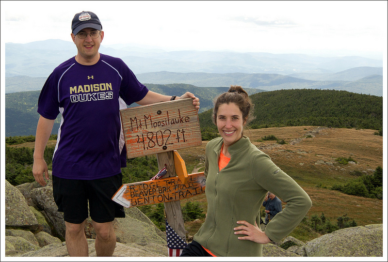
As soon as we were in the open, I had to dig my fleece out of my backpack. It was a good 15-20 degrees colder (and much windier) on the summit. We enjoyed a snack, took our photos at the summit sign and marveled at the views. I especially liked looking across and seeing the Kinsmans, Franconia Ridge and the distant Presidentials.


Leaving the summit, we briefly followed the white-blazed Glencliff trail (which is also the Appalachian Trail across this mountain) to its junction with the Carriage Road. This section of trail was almost perfectly flat and went through more areas that resembled large groupings of Christmas trees. We could have taken a detour to visit the South Peak of Moosilauke, but we decided to skip it.
The Carriage Road was wide and graveled, but a little steep. I can’t imagine people coming up this route in horse-drawn carriages! This part of the hike was pretty uneventful, and we were glad to finally reach the Snapper Trail.
The Snapper Trail descended gradually through stunningly beautiful New England woods. There were thick beds of moss, peeling white birches and several small bubbling streams. It was a lovely way to bid farewell to New Hampshire trails. Before we knew it, we were back at the Ravine Lodge and finished with a productive week of hiking!
Adam Says…
Mt. Moosilauke was one of the three hikes we most wanted to do in New Hampshire. Having hiked Mt. Washington and Franconia Ridge earlier that week, we were feeling a little tired and sore but we decided to press on to cover Mt. Moosilauke. We try to get a lot accomplished on our vacations, so we didn’t want to have any regrets of not doing a certain hike. We always say that we can be tired when we go back to work, so we run ourselves ragged on our vacations.
Parking at Mt. Moosilauke can at times be a challenge. There is one long gravel road and during the summer, you will likely see cars lining one side of the road, parallel parked. We had to drive to the end of the road and then turn around and backtrack, but we were able to find a decent spot since we left so early in the morning.
We first visited the lodge and you can just imagine the history here. The lodge is rustic but has that snuggle-by-the-fire cozy feel to it. Since this is maintained by an Ivy League school, my mind began to wonder if there were academic secret society meetings held here or if famous alumnus, Robert Frost penned any of his poetry here. All I witnessed were a few students playing Magic: The Gathering in the basement.


The trail had us a little confused to start off on the right path. My recommendation would be to go to the back of the lodge and as you are looking into the backyard, head down the lawn towards the right. You will soon come to a path that will lead you to the Baker River. In a short distance, you will cross the bridge over the river. The Gorge Brook Trail starts off to the left. The trail takes a right turn in a short distance and you begin a moderate ascent through a very rocky trail. You’ll hear the sounds of the Gorge Brook to the left of the trail at times as it carries water to the Baker River. As you keep climbing, at .6 miles you will reach the junction with the Snapper Trail, your return route. The trail has been rerouted at this point with the Wales Carter Connection. Follow the signs through this .5 mile connection to continue along the Gorge River Trail. The trail continues to ascend through a steeper section of trail through the woods.
At 2.3 miles you reach a break in the trees and can see your first views of Mount Carr, Mount Cardigan, and Mount Kearsarge. The trail continues to ascend and then loops back around to the northwest as you gain some more views from the area known as The Balcony at 3.0 miles. The views were quite delightful and gave us something else to focus on as we labored up more rocky steps. The trail then ducks away from the views and you find yourself soon immersed into a dense forest of spruce and fir as the trail snakes through. You will see signs reminding you to stay on the trail to protect the fragile vegetation. At about 3.25 miles, you will come out of the trees and into the open alpine area. Large cairns are placed on the side of the trail. The summit looks misleadingly close, but due to the open nature it still takes about 10 minutes to reach the summit at 3.5 miles.
At the summit, the wind had picked up quite a bit across this vast, open area. We found lots of people huddled up against rocks, trying to protect themselves from the wind. We ate some lunch on the trail, snapped a few photos from the summit, and made our way back on a different set of trails.


From the summit marker, we followed the signs for the Glencliff Trail (also known as the Appalachian Trail) southwest of the summit. This trail started off as a ridgeline hike which gave us even more views along the way to start our hike. At 4.4 miles, the Appalachian Trail ducks off to the right to take you to the South Peak summit. We stayed on the main trail which is the Moosilauke Carriage Trail, which drops steeply down the rocky “road”. The trail was fairly uneventful, but the downward climb can be hard on the knees. At 5.7 miles, we reached a junction and took the Snapper Trail. This trail was thickly wooded and had lots of beautiful fern along the trail. At 6.4 miles, we rejoined the Gorge Brook Trail and made our way back to the lodge, which we reached at 7.2 miles.


One thing that amazed me about this hike is how Dartmouth College has integrated with and adopted this mountain. They maintain and run the lodge and the network of trails is maintained by students in the Dartmouth Outing Club. We had the opportunity on our visit to New Hampshire to step on the campus and actually walked into the Dartmouth Outing Club building. Yes, this college has a building designated for this club and they even post information for Appalachian Trail thru-hikers to get them connected to where they could stay for the night. I was amazed at how the students have made this a strong tradition of caring for the mountain and environment. They even hold freshman pre-orientation trips where they all meet up at the Ravine Lodge. I wish more colleges and universities had more intentional connectivity with the outdoors.
What a great last hike for our trip to New Hampshire! We felt so blessed to have great weather for the entire week and our hiking adventures whetted our appetites for more trips in the future.
Trail Notes
- Distance – 7.2 miles
(Check out the stats from MapMyHike)*
- Elevation Change – About 2500 ft.
- Difficulty – 3. There may be over 2,000 feet of climbing, but it’s gradual and never feels that difficult.
- Trail Conditions – 4. The Dartmouth Outing Club does a great job on these trails!
- Views – 5. Spectacular – especially at the summit where you can see all across the White Mountains.
- Waterfalls/streams – 3. The Baker River and streams in the area are lovely.
- Wildlife – 2. We didn’t see anything, but rumor has it that there are occasional moose sightings in the area.
- Ease to Navigate – 3. The reroute was a little confusing at first because it varied from our map.
- Solitude – 1. This is an extremely popular dayhike. Expect to see many other hikers.
Download a trail map (PDF)
Directions to trailhead: From Interstate 93, take exit 32 for NH-112 toward North Woodstock/Lincoln. Follow NH-112 West for 3.2 miles. Take a slight left onto NH-118 S/Sawyer Highway. Follow this for 7.1 miles. Take a right on to Ravine Road. Follow this gravel road for 1.5 miles. The entrance to the lodge is on the left. Go behind the lodge across the lawn to the right to start the hike.
* MapMyHike is not necessarily accurate, as the GPS signal fades in and out – but it still provides some fun and interesting information.

dartmouth alum here. Students and alums will occasionally hike this in the winter and ski down the carriage road if there is coverage. I also helped with some trail work on the Glencliff trail further down than where you were.
Many of the water bars on the carriage road, and a lot of the stone work done on Gorge Brook are/is the work of Put Blodgett, who even recently is still performing trailwork on the mountain, despite graduating back in 1953. He’s also one of the best canoe paddlers in the North East.
LikeLike
The trails on Moosilauke are fantastic! We were really impressed with their construction and maintenance. Thanks for the visit!
LikeLike
I did this exact loop several years ago in the winter. It’s a beautiful hike, and if you ever get to go up for a winter trip, put this one on your list.
LikeLike
I’ve heard it’s a pretty popular loop for snowshoes and cross country skies. The winter photos are gorgeous!
LikeLike