
This 1.8-mile, moderately steep hike takes you to the summit of Hawksbill Mountain where you can enjoy stunning views of Linville Gorge.
View the full album of photos from this hike


Christine Says…
Shenandoah National Park has a Hawksbill Mountain. It’s a nice hike and has lovely views, but Hawksbill Mountain in North Carolina’s Pisgah National Forest is even more impressive! With a dramatic skyline of mountains with interesting profiles and a plunging view into Linville Gorge, this short hike offers scenery unparalleled by our Virginia Hawksbill. (sorry… I have to be honest!)
Adam and I woke up early on our last morning at the Pineola Inn. After a grueling day on Grandfather Mountain, we were in search of low-key hiking. My knee was hurting; every step I took on even the slightest downhill elicited stabbing pain under my kneecap. I thought to myself, ‘if only we could find a hike without much elevation change, I can gut this out!’ I referred to our hiking guide for the Blue Ridge Parkway and found a few short, easy hikes in the Linville Gorge area. The first was Hawksbill. The description was pretty vague, but it sounded easy and short – good enough to fit the bill for the day.
We had breakfast and made our way to the trailhead. The drive down Table Rock Road was dusty, bumpy and pitted with axle-rattling potholes. Fortunately, we were on the road only a short while. We parked near the trailhead and started up the Hawksbill Trail.
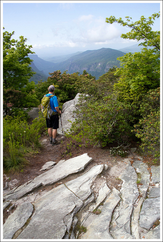
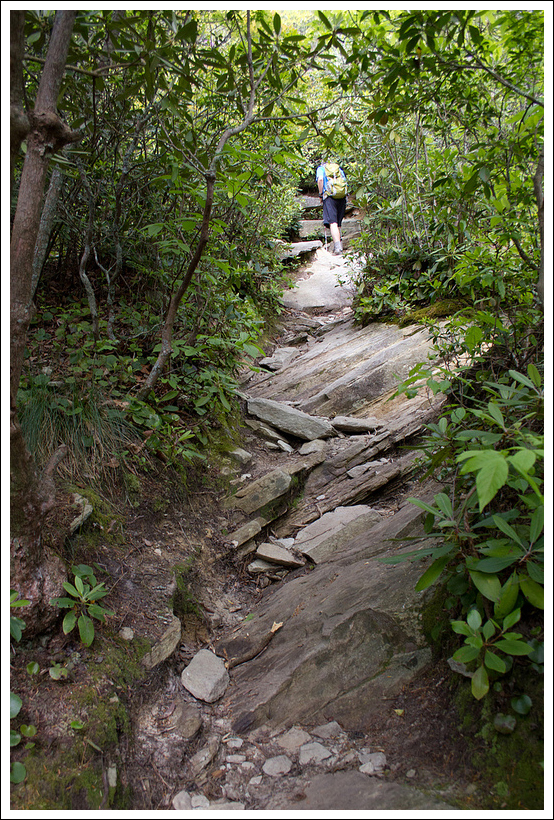


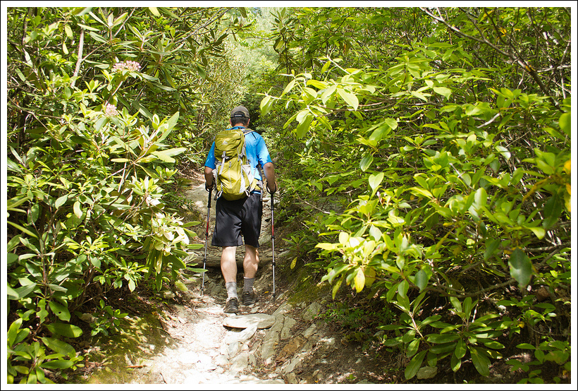
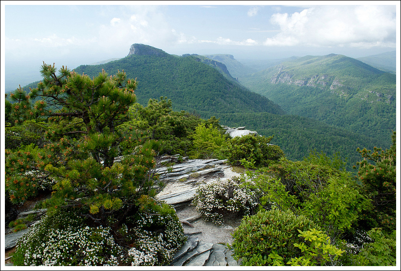
There’s really not a lot you can say about a .9 mile trail that pretty goes straight up a mountainside. There weren’t many noteworthy features on the route. It started off gentle, but became increasingly steep and rocky as we approached the summit. We saw mountain laurel and Catawba rhododendron blooming along the way. After a short while of walking, the trail leveled out on a rocky summit. At first, we didn’t see any views. But then we followed a series of worn footpaths through the brush and over boulders. On the other side, we found magnificent views that far exceeded any expectations we had for the hike. Linville Gorge is a precipitous plunge from the summit of Hawksbill. If you look deep into the canyon, you can see the river trailing through the forest. All the mountains around the gorge have unusual shapes. Instead of gentle rounded domes like most mountains, they have cliffs and plunges and missing chunks.
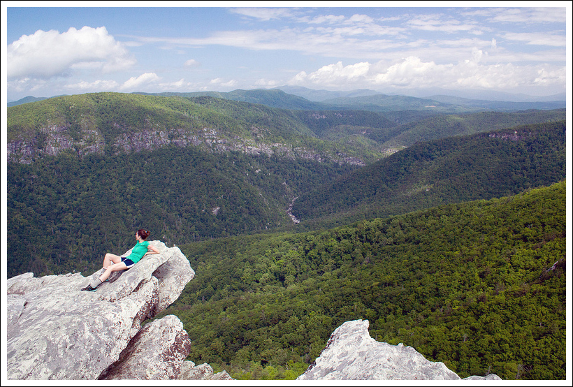
There were tons of places to sit and enjoy the views in every direction. When we visited, morning clouds were still swirling around the summits – making the vista even more dramatic. We saw a large group of cedar waxwings cross the summit, pausing to eat berries from the trees. Much of the summit was crowned with sand myrtle. And best of all, we had the entire place to ourselves! We stayed up there for about 45 minutes before climbing back down.
On the descent my knee nagged at me, but I still wanted to get one more little hike done after Hawksbill! Because, what would a visit to the Linville Gorge area be without a visit to the famous Linville Falls? We opted to stop for lunch at Famous Louise’s Rock House before visiting the falls. The restaurant sits simultaneously in three different counties (Burke, McDowell, and Avery), and is very well known for its pies. I enjoyed a slice of their five fruit pie with ice cream, then it was on to our final hike of the trip!


Adam Says…
When we started off our hike from the parking lot up Hawksbill Mountain, there were lots of cars at the trailhead. After seeing some of the people preparing for the walk, we noticed they were bringing a supply of ropes and carabiners for rock climbing. As it turns out, Hawksbill is more popular for rock-climbing than hiking, featuring several moderate and difficult routes. We jumped on to the trail not knowing how many people we would see, but as it turns out we were the only ones hiking the trail on this gorgeous day.


The trail started off very gradual, which felt fine to our sore joints from hiking up Grandfather Mountain the previous day. At .6 miles, the trail took a sharp left up the mountain. I’m not sure, but this may be the point that the rock climbers veer off the main trail since we saw a faint trail leading out from this point. The trail then becomes more steep and there are some very large steps to take in places up rocks to keep climbing up the trail. At .8 miles, we reached the height of the trail. We headed to the left and within a short distance, we could see the views open up. We walked on a faint trail at the top until we reached a nice rock outcropping to take in the views of the gorge. Across from this viewpoint was Table Rock and Short Off. We talked about how we would like to come down here again and hike those two. As we were taking in the views, we saw several cedar waxwings chasing each other in the air.
We initially thought this viewpoint was what we came to see, but I wondered where the rock climbers were. So, while Christine took some more photos, I decided to scout back to the top of the trail we traveled and headed the opposite direction. I could tell this opened up to even grander views, so I backtracked and brought Christine back. We walked about .1 mile to this other viewpoint which had a large rocky cliff-face to take in the view. We climbed around on the rocks for a while taking in the views of the gorge and mountains. One rock that I stood on pictured above wobbled a bit when I stood on it, so be very careful on the edges!
We made our way back to the trail, again not encountering any other people. We were so glad that we had found this gem of a hike. This is another one of those hikes that has outstanding views with not a lot of effort. I would recommend it to anyone visiting the Linville Gorge area.
Trail Notes
- Distance – 1.8 miles
(Check out the stats from MapMyHike)*
- Elevation Change – About 700 ft.
- Difficulty – 2. A little bit of the hike is steep and rocky, but it’s so short that most people should be able to tackle the route with ease.
- Trail Conditions – 4. The trail is in nice condition.
- Views – 5. Beautiful views of the gorge, Table Rock Mountain and Short Off Mountain
- Streams/Waterfalls – 0. None.
- Wildlife – 2. We saw a flock of cedar waxwings and a lizard.
- Ease to Navigate – 4. The trail is a straight shot up the mountainside. There are a variety of footpaths around the summit, and lots of places to take in the view.
- Solitude – 4. Oddly, we did not see a single other person after we left the parking lot. We had the summit all to ourselves for a full 45 minutes.
Directions to trailhead: From Banner Elk, NC (a good hub for this area). Follow NC 105 south for about eight miles, turn left on NC-181 S/US-221 S/Linville Falls Hwy for about three miles, turn left onto NC-181 S/Jonas Ridge Hwy for six miles, turn right onto Ginger Cake road and continue onto Table Rock Rd. The trailhead will be marked with NFS signage.
* MapMyHike is not necessarily accurate, as the GPS signal fades in and out – but it still provides some fun and interesting information.

Nice, thanks! I have been there but only saw the he Table Rock. I will be there next week and can hardly wait!
LikeLike