Introductory Guide to Visiting the White Mountains
This 4.5 mile ascent of Mt. Washington follows challenging, steep, slick terrain along a ravine that showcases waterfall after waterfall. Once you clear the treeline, you are treated to a hut visit and some of the most dramatic alpine walking in the east.
View the Full Album of Photos From This Hike

Adam Says…
Hiking to the summit of Mount Washington (also known as ‘the most dangerous small mountain in the world‘) was definitely a bucket-list item for me. Making it to the top of the highest peak in New England feels like an accomplishment and we definitely have memories from the hike that we will never forget.
Before you attempt to hike up Mount Washington, some planning needs to take place. Mount Washington has been called the Home of the World’s Worst Weather due to the high winds, ice, and low visibility that can rear quickly. In fact, in 1934, they recorded a wind gust of 231 mph. Check out the funny video of someone trying to eat breakfast from the summit area during one of these high wind days. Needless to say, I would strongly recommend checking out the weather from the Mount Washington Observatory to determine if a summit is possible and how different the weather and temperature will be at the top.
We arranged for Christine’s parents to meet us at the top and shuttle us back to our car. Many people descend by trail, but there is a hiker shuttle and a limited number of seats available on the Cog. It’s important to note that you should always be prepared and have a plan for walking off the mountain. Trains and shuttles book up quickly and the auto road closes from time to time. Ultimately, you are responsible for your safety and the manner of your descent. Visit New Hampshire’s Hike Safe site so you can learn more about mountain safety and the state’s expectation that every hiker be prepared.

As we were driving along the road to the parking lot, the sky was completely cloudy. The online forecast said it was going to be a perfect day, but the clouds were saying something different. We hoped that the weather would push off and made it to the parking lot. We packed some extra gear knowing that the temperature was going to be much cooler at the top. We started off from the parking lot and filled out our parking permit, enclosing $3 in an envelope to allow us to park in the lot. The parking lot was already getting full and we could tell that all the people getting ready to hike were in great shape. We hoped we were ready for the challenge and started on the Ammonoosuc Ravine Trail from the end of the parking lot. The trail started off relatively flat through a thickly forested area. At .25 miles, we reached a stream crossing. Because a heavy rain fell just the day before, the crossing, which is normally easy, presented a real challenge. We saw a few others cross in different areas, but ultimately decided the best route was tightrope-walk across a thin log that spanned the creek. This is always more unnerving when you are carrying expensive camera gear, but we made it across without a hitch. We were worried how many other crossings we would have to make seeing the Ammonoosuc River on our trail map coming ahead.
At 1.0 miles, the trail reached the Ammonoosuc River, but the trail turned quickly to the right. We saw the rushing water of the river and glimpsed up at the sky, which looked less foreboding than earlier. The trail hugs the riverside and begins a steep ascent up a rocky slope. At 2.1 miles, we reached the Gem Pool, a serene swimming hole created by a small waterfall. We rock-hopped across to continue the path from the pool and stopped for a short rest in this peaceful area. After leaving the Gem Pool, the trail becomes very steep as you climb up the rocky slope. At 2.35 miles, a small trail to the right leads about .1 miles to The Gorge waterfall. I highly recommend checking out this waterfall, which you can see plunging over 100 feet. We returned from The Gorge and rejoined the trail. The trail continues its steep ascent and you can only imagine that you are climbing up a slope that seems to be as steep as the slope of the waterfall you just saw.

We continued to climb up the very steep slope until we reached a great viewpoint at 2.7 miles. Along with the view, there were also multiple waterfalls falling in dramatic cascades. It was here that we were finally able to see that the clouds had moved off and we should have a gorgeous hike to the summit. The unnerving thing was that in order to continue the trail we had to walk across the top of a waterfall with a very precipitous drop to one side Due to the rain, there was no way to rock-hop across. We knew we had to put our feet in the water to make it across, but we couldn’t tell how deep the water was or how fast it moved. As we realized that a false step could have meant a long plummet down, it definitely gave us a gut-check to see if we could make it. We tried to look around for the best way to cross and decided to wait and let a few other hikers attempt it first. After learning what others had done, we followed suit and crossed without any difficulty.
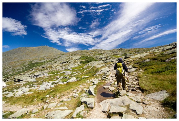
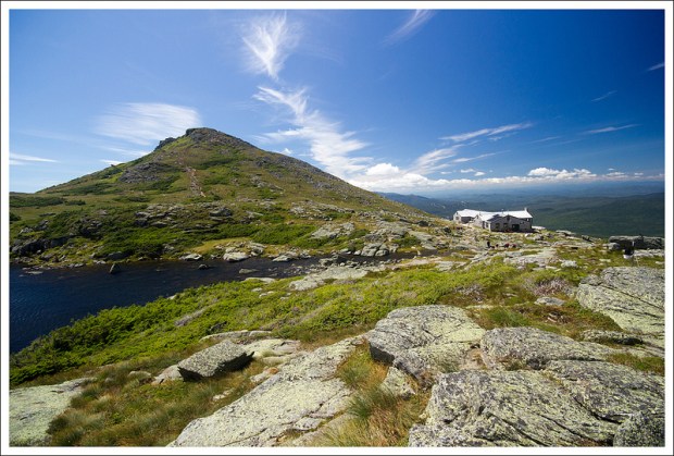
The hike from this point continued to be steep as you climb along some areas of bare, slick rock. Eventually, we began to rise above treeline and were able to see Lakes of the Clouds hut seated on the edge of the ravine. The wind was already picking up and the cold wind had us switching into cold-weather clothes. To the left of the hut was the summit hike to Mount Washington and we could clearly see the Observatory Tower in the distance. We reached Lakes of the Clouds hut at 3.2 miles and decided to go inside to eat a snack.
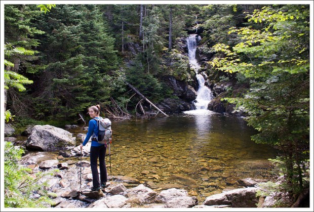
- One little spur trail on the steepest section of climbing led to this large and impressive waterfall called Gorge Falls. Below: Christine picks her way through boulders and across the water; Our first views into the Washington Valley; At the halfway point
Lakes of the Clouds Hut was built here over 100 years ago and has some interesting history. Two AMC members, William Curtis and Allen Ormsbee, were hiking up the Crawford Path to go to an annual AMC meeting at the Summit House on the top of Mount Washington in 1900. They reached what is now Mount Eisenhower and met 60 mph winds and cold temperatures. By the time they reach Mount Monroe, the temperature had plummeted to freezing and the rain became ice. Curtis died at Lakes of the Clouds and Ormsbee pushed on for help before perishing himself only a few hundred yards from the summit station. The storm lasted for 60 hours and their bodies were discovered. The AMC created a wooden shelter first near where Curtis had died. In 1915, the wooden shelter was replaced with a stone shelter and it has since had several additions and improvements made. It can accommodate up to 90 guests per night.
From the shelter, you can see a trail that leads up to Mount Monroe. If you are interested in peak-bagging a few of “the Presidentials”, it is a short but steep hike. We decided to save our energy and just tackle Mount Washington. We continued along the trail and soon reached views of the Lakes of the Clouds, which are actually more like mountaintop ponds than full lakes.
Since we were now above treeline, the hike to the summit of Mount Washington was now just a series of steps across boulders for the remaining 1.3 miles. The wind was incredibly strong and I believe gusts were at least 50 mph, which is considered more of a calm day on the mountain. The wind was blowing up the ravine to the left of our bodies, so there were times that we had to angle ourselves to fight the winds as we pushed onward. The views of the ravine and behind us were more breathtaking with each step. Whenever we stopped to turn around, the wind had our noses running from the cold and it was hard to even talk to each other through the force of the gusts.

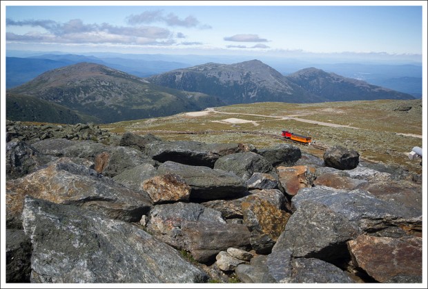
At 4.5 miles, we reached the summit area. We followed the signs to the summit marker, that was crawling with people. Most people reach Mount Washington by car or by the cog railroad. When you pay to take the Mount Washington auto road, you receive a sticker that states “This Car Climbed Mt. Washington”. We waited our turn to get a picture with the summit sign. Some people were amazed that we had hiked up. We made our way over to the visitor center and snack bar. We had agreed to jokingly meet her parents by the “death plaque”, a plaque that shows a list of the names of people who have died on the mountain. When we arrived at the snack bar area, a group of hikers we had seen earlier on the trail whispered to us “there’s a hiker’s lounge downstairs”. While the upstairs area was crawling with people, the hiker’s lounge was quiet and nearly empty. We had a peaceful time to eat our lunch and then were able to meet her parents in about 30 minutes. From here, we jumped in their vehicle and enjoyed the car ride down the narrow road that snakes down the mountain. We stopped a few times along the way to catch some last views of the Presidential Range before we were back on the road.
The hike up Mount Washington was definitely something that Christine and I felt that we wouldn’t have been able to accomplish several years ago. I can’t think of any other time that I have felt such a sense of accomplishment after reaching this summit. We were so blessed with the great weather and we have already begun talking about how we could do an entire hut-to-hut Presidential traverse.
Christine Says…
With our days in New Hampshire running out and great weather in the forecast, we decided we had to tackle Mt. Washington. With a reputation for fickle weather, ice storms that happen at the height of summer, and gusts of wind that can blow a grown-man sideways, I wasn’t quite sure what to expect. The night before our hike, we were looking at maps and guidebooks and discussing our different route options. Across the living room, my mother was Googling ‘deaths on Mt. Washington‘, ‘failed hikes of Mt. Washington‘ and ‘accidents on Mt. Washington’. Comforting, right? She also told me to make sure I had the phone number for New Hampshire’s Fish and Game department on hand – they do most of the mountain rescues in the state. Her worries and cautiousness got into my head, and I went to bed feeling really nervous about my ability to make it to the top.

On the drive to the trailhead, dark blackish clouds completely obscured the mountain. I said to Adam, ‘This is probably a bad idea.’ He reassured me, telling me he was certain the clouds would blow off, the day would be beautiful, and that we would have a great time. I let my worries non-verbally stew in the back of my mind. We parked, geared up and made our way down the trail with several other groups of people.
Within the first mile, we came to a rain-swollen stream with no clear way to cross. The rocks normally used to rock hop were all under rushing water. I tested a few spots, and ended up falling shin deep into water and wrenching my knee. I was feeling discouraged, because the only other potential crossing left was a thin, bouncy, moss-covered log that had fallen across the stream. I have problems with vertigo and balance, so situations like this really push me outside my comfort zone. Adam carried all the expensive camera gear, and I slowly and carefully stepped across that log. Phew! I told Adam if there were lots of crossings like this one, I didn’t think I could do the hike. He offered to turn back, but I told him that I wanted to challenge myself and keep going.
Fortunately, most of the hike followed alongside the stream with only a few much easier crossings along the way. Eventually we reached the Gem Pool. What a gorgeous spot! It’s a crystal clear, green, pool; fed by a cascading waterfall. It would be a great place to take a picnic and go for a swim. We did one more rock hop at the end of the pool and prepared ourselves to do some serious climbing!

About 1600 feet of elevation gain comes in just about a mile of hiking after you pass the Gem Pool. It’s grueling and steep, but both Adam and I were well-prepared with all the hiking and other cardio we’d done to prepare for this trip. We were able to make the ascent without having to take a breather! The only stop we made along the way was the side trail to check out the Gorge Waterfall.
On the climb up, we started seeing glimpses of the valley through the trees. The majestic Mount Washington Hotel looked like a tiny red speck below. We’d come a long way up already! The remainder of the steep climb followed the Ammonoosuc River through the plunging ravine. Even when we couldn’t see the water, we could hear it.
Eventually, the trail exited from the woods onto a wide rock plateau. Above, we could see a waterfall falling in several distinct drops and below, we could see the water crashing over a steep, long drop. We decided to take a break and enjoy the view from the rocks. We sat for a minute taking it all in. At that point, I noticed I didn’t see the trail continuing anywhere. Horror dawned on me when I realized that the trail continued on the other side of the river. We saw two people cross it successfully, but I still wasn’t so sure. The water was fast and a little deep from the rainfall the day before. I had no idea how slick the rock under the water would be. The crossing had just a couple feet of flat width on the downhill side before the water dropped over a 100 feet down into the ravine. A slip at this crossing would almost surely be fatal. I took a moment to hyperventilate and freak out, and then I plunged across. This was followed by another ‘Phew – I’m still ALIVE’ moment.

After that crossing, the hike was less steep but a lot rockier. The trees were getting smaller and more stunted as we approached the treeline. We could see the summits of both Mt. Washington and Mt. Monroe looming above. Lakes of the Clouds Hut was in view, but distances are so deceptive above treeline. Everything looks so close, but it’s always further than you expect. I guess it’s a bit of an optical illusion when you don’t have trees to compare for scale.
As soon as we broke the treeline, just slightly below the hut, the wind was shockingly strong. I was hiking in long pants and long sleeves, but I had to add my hooded jacket right away. Even so, my face and hands were freezing! I was sure I had packed gloves. I usually keep a spare pair in all my backpacks, but I couldn’t find them anywhere. I ended up paying the premium price to buy a cheap pair of gloves at the hut (only to find the spare pair of gloves in a side pocket that night when we got home).
We took a twenty minute break at the hut and enjoyed some of the baked goods made by the Croo. Adam had pumpkin cake and I had chocolate cake. I had my phone with me, so I decided to take a look at MapMyHike to see how we were progressing. I found that Lakes of the Clouds actually has 3G service, so I posted an Instagram and a Facebook status from the hut. Ah… technology! 🙂

After our snack and rest, we were ready to tackle the last mile and a half of trail to reach the Mt. Washington summit. I can’t even describe how much I enjoyed this portion of the hike! The climb up the Ammonoosuc ravine had been moderately scary, physically challenging and really slippery, but the hike along the Crawford Path was pure, unadulterated hiking joy!
The Crawford Path was built in the 1800’s and originally used as a horse trail to the summit of Mt. Washington. The trail celebrated its 175th anniversary in 1994 and is the oldest, continuously maintained, hiking path in America. I felt so privileged to be walking someplace so beautiful and historic.
We spent some time exploring and photographing the glacial ponds that give Lakes of the Clouds its name. On this particular day, the pools were sapphire blue and covered with scalloped ripples from the brisk wind. It was spectacular and gorgeous.
We toiled along, pushing our bodies against the 50 mph winds. The alpine terrain was breathtaking and otherworldly. I’ve never seen mountain views like the ones I saw in New Hampshire on this trip. Between the walk along Franconia Ridge, and then the hike along the Crawford Path, I had my mind blown twice in one week. These places should be on every American hiker’s bucket list!

The stretch of trail between the hut and the summit is a rock field. Sometimes the rocks are wide and flat, sometimes they are uneven, loose and pumpkin-sized. The trail isn’t so much a path as it is a series of cairns that keep hikers on course.
At first, the trail between the hut and Mt. Washington was pretty flat, but the final push to the summit required a little more steep climbing. The weather station towers looked so close you could almost touch them, but it turned out they were still about a half mile away.
We could tell we were getting really close when we started seeing more and more people in jeans, sneakers and sweatshirts milling about the trail. These were the car and train people! Eventually the trail emptied us out onto the summit. We passed the historic hotel-turned-museum – Tip Top House – and made our way over to the summit marker. We actually had to wait in line with all the car and train people to have our picture taken at the summit sign. It’s always funny to finish a hike that has a summit that can also be reached by car – Clingmans Dome comes to mind (the high point on the Appalachian Trail).

After taking our obligatory summit photo, we grabbed some drinks and hot dogs from the summit building’s snack bar and waited in the hiker’s lounge. My parents still hadn’t arrived, so we had about a half hour to kill. It made me wish we actually had taken the time to do the short side-trip climb to the summit of Mt. Monroe when we had been at Lakes of the Clouds. I just didn’t want to leave my parents waiting in case we took longer than expected. I didn’t want them to worry more than they had to.
Every 10 minutes or so, I ran up the stairs to look for my parents. On the third trip up, I spotted my father and my (nervous-looking) mother waiting by the death sign. I know it sounds kind of mean to have them meet us there, but honestly, it’s the easiest ‘landmark’ to find in the summit building. The place is so crowded that you can’t really say ‘meet me by the snack bar, museum or gift shop’. My parents were both relieved and impressed by how quickly we’d made it to the top.
Honestly, other than the two nerve-wracking water crossings, the hike up Mt. Washington was not nearly as difficult as I expected. The elevation gain was challenging, but I think it would be doable for most reasonably fit people. And the walk from Lakes of the Clouds to the summit was a pure pleasure, and definitely one of my most memorable hikes ever!
Trail Notes
- Distance – 4.5 miles
(Check out the stats from MapMyHike)*
- Elevation Change – About 3800 ft.
- Difficulty – 5. The steepness of the hike is no joke. The winds and weather possibilities just add to the difficulty.
- Trail Conditions – 3.5. The trail is well-maintained, but there were some stream crossings, loose and wet rock that made this tough in some parts.
- Views – 5. Once you rise above treeline you have great views of the ravine. The view from the top of The Gorge is also nice.
- Waterfalls/streams – 5. You get the rushing waters of the Ammonoosuc River, the Gem Pool, The Gorge waterfall, and Lakes of the Clouds.
- Wildlife – 1. We didn’t see much other than squirrels. Some moose have been spotted near the lower parts of the trail.
- Ease to Navigate – 4. Junctions were clearly marked. The hike from Lakes of the Clouds to the summit could be difficult on foggy/rainy days, but follow the cairns.
- Solitude – 2. On a gorgeous day, there were lots of people. But, due to the danger of hiking this trail, that is probably a good thing to have others nearby. We were always able though to find our own space to enjoy views.
Download a trail map (PDF)
Directions to trailhead: From Interstate 93, take exit 35 to merge on to US-3. Take US-3 for 10.4 miles and then take a right onto US-302 East. In 4.4 miles, take a left on to Base Station Road. Follow this about 5.7 miles until you reach a large gravel parking lot on the right. The trailhead can be found as you entered on the lefthand side of the lot.
* MapMyHike is not necessarily accurate, as the GPS signal fades in and out – but it still provides some fun and interesting information.


this is a great report and I hope that I have as good an experience as you did.
LikeLike
What time of year did the hike occur?
LikeLike
We hiked the trail in early August.
LikeLike
Awesome trip report. Very detailed and very helpful. I’m thinking of hiking this route to the summit. Thanks!
LikeLike
Thanks for the visit, Sheri! It’s a beautiful route – so scenic!
LikeLike