
This 3 mile out-and-back leads to the towering (literally) summit of 5,721 ft Mt. Pisgah. Due to the short length and proximity to lodging, a camp store, and a picnic area, this trail is exceedingly popular with families. The summit offers some nice views, but the presence of a huge television tower detracts from the natural beauty of the area.
View the Full Album of Photos From This Hike


Christine Says…
Our second day in Asheville was just a half day, but we wanted to get a little more hiking in along the Blue Ridge Parkway before making our way down to Bryson City and the Smokies. Breakfast was at the popular Sunny Point Cafe. We got there just a couple minutes before they opened and were able to snag the last open table for two! It’s a very popular spot, so be prepared to get there early or have a long wait.
After breakfast, we headed up to the parkway to climb Mount Pisgah. Our book talked about great views, but described the hike as ‘strenuous’. In fact, there was a warning sign at the trailhead indicating that the hike was tough and steep. It actually only climbs about 700 feet, but it does so in a short distance. I suppose the warning is necessary for novice hikers or people who think they’re just out for a casual stroll.
The hike started out from a parking lot atop the Buck Springs Tunnel. There are actually a couple trailheads in that area – Mt. Pisgah, Shut-In Trail and the Buck Springs Trail. To get to the Pisgah Trail, drive to the far end of the parking lot.


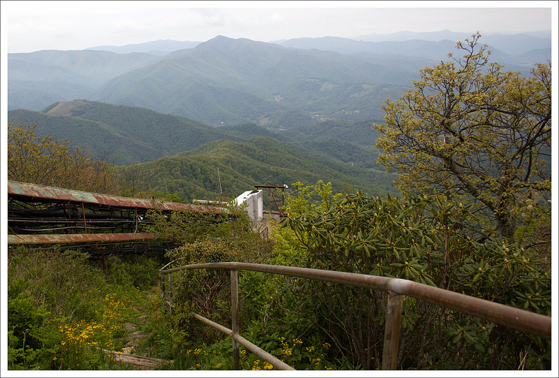
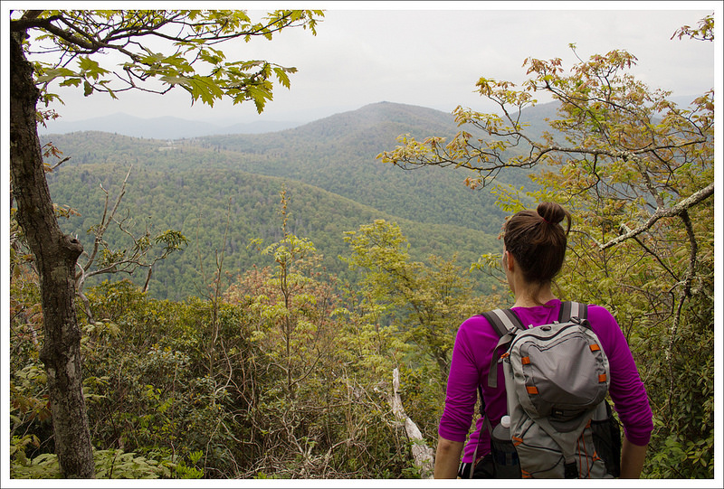
The hike started off gentle and flat – just a pleasant walk through the woods. We could see the conical summit of Pisgah, replete with its television tower, looming through the trees. The trail made a sweeping turn at around .4 miles and began a steady uphill climb. It was rocky and rough at times, but overall a moderate ascent. A couple tenths of a mile before the summit, we came across one nice view across the mountains.
After the nice view, we made the final push to the top. The summit has a wooden viewing platform and a serious eyesore of a television tower. I know they’re necessary, but I wish they could have put it on a less scenic, more remote peak! All that metal really ruins the scenic beauty of such an impressive summit.
We sat on the summit for a while. The views would have been pretty nice, but the day was overcast and hazy, so that took away some of the majesty from the experience. I think we were also the only people on the summit without kids! Mt. Pisgah is clearly a very popular family hike! There were more three-year-olds on that mountain top than any other demographic. I guess it makes sense – the hike is short, moderate and doesn’t have any steep drop-offs — perfect for a family with small children.
We hiked down the way we came, making speedy work of the descent. Now… on to the Smokies!
Adam Says…
When we’re on vacation, we like to alternate longer hikes with shorter hikes to make sure we still have energy at the end of our trip. When we were researching different hikes to do near Asheville, NC, we came across Mt. Pisgah. With it being such a short hike and the trailhead being sort of en route to our next town stop, we thought this was a winner. We also read about wonderful views from the top so we figured it would be a high payoff for minimal effort.
The trail started off following a slight incline for the first few tenths of a mile. Then the trail went up more steeply in elevation and can be challenging at times. But, since the hike is pretty short, it is attainable by most people. We saw more families hiking on this trail with little children than anywhere else. While many of the kids were walking the trail in the beginning, we found most of them were being carried by the time they reached the summit.
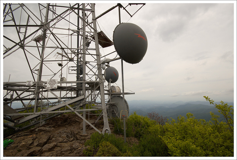


We arrived at the top in well under an hour. The tower was such an eyesore and we both were thinking this would be so much nicer of a hike without the 339-foot tower there. The wooden platform allowed for about 270-degree views (90 degrees taken up by the tower). While it was hazy, I could tell that on a clear day you would be able to see for quite a distance.
The origin of the name of the mountain comes from the Bible. The Reverend James Hall is attributed to being the first to call this area as “Pisgah”, taken from the biblical reference to the peak where Moses viewed the promised land. The Pisgah National Forest was historically owned by the Vanderbilts (who built the nearby Biltmore House in Asheville). 500,000 acres were sold to the government by the Vanderbilts as an effort to help preserve this land.
If you are interested in geocaching, there are several to find on this trail:
- Tumble Rock
- Gnarly Tree
- My Favorite Hike
- Atypical #29: Carrot Top
- Steep Steps
- Mt. Pisgah
- Mt. Pisgah Too

While this hike does have some nice views from the top, we were a little disappointed by the size of the tower and the popularity of the trail. As Christine mentioned, it would have been nice to have this on a more remote mountain (and also not the namesake for the entire National Forest).
Trail Notes
- Distance – 3 miles
- Elevation Change – 700 ft
- Difficulty – 1.5. This trail is short with a moderate ascent.
- Trail Conditions – 4. The trail was generally in good condition.
- Views – 3.5 – Typically views from a peak like this would get higher marks, but the tower is such a distraction.
- Streams/Waterfalls – 0. None
- Wildlife – 1. Maybe some birds and squirrels.
- Ease to Navigate – 5. There is only one trail to the top, and it’s very easy to follow.
- Solitude – 1. This trail is popular and heavily traveled.
Download a Trail Map (PDF)
Directions to trailhead: From Asheville, take the Blue Ridge Parkway south to the Mount Pisgah Parking Area, on the left, at milepost 407.6. Park at the second parking area.

Nice write up – reminds me of a hike I made in NH a few years back up Mount Kearsarge. There was a tower on the top, and these guys had packed in a repair piece that had to have weighed 100 pounds! Also, where I used to live in Maine was a hike up a Mount Pisgah – a mile or two up and then back with incredible views and just a few miles from my house. It had a firetower on top that you could climb. On a clear day, we could see Mount Washington some 100 miles away.
LikeLike