
The Pinnacle is a 6.6 mile hike with a strenuous climb for the first two miles. Hikers are rewarded on a clear day with spectacular views from a rocky ridgeline and overlook point.
View the Full Album of Photos From This Hike


Adam Says…
This hike has an incredibly generic name. I can’t recall how many hikes we have been on with the name “Pinnacle” in the title. The same can be said about “bald” (“bald knob”, “bald rock”, etc.), “buzzard” (“buzzard rock”, “buzzard roost”, etc.), “black rock”, and “devil” (“devil’s marbleyard”, “devil’s stairs”, “devil’s bathtub”, etc.). While the hike name lacks originality, by using the word, “pinnacle”, hikers should expect great views and this one doesn’t disappoint.
Getting there caused us a bit of confusion because the directions we had seemed to want us to drive on private property. However, we stayed on the main road and it soon came to a dead end at Pinnacle Park. We parked and completed the permit form at the kiosk, which were quite damp since they were exposed to the elements. Just past the kiosk was the trailhead that led through a gate. As we were starting our hike, there was also a couple of women that were getting started as well. They had backpacks to help carry their toddlers and they were taking the trail all the way to the Blue Ridge Parkway, where they had dropped off another car. They said they were quite familiar with the trail. After we saw the steepness of the terrain, we were impressed with these young moms.


The day started off foggy and incredibly humid from the recent rains, which made the footing a bit tricky for parts of the hike with either slippery rocks or muddy areas. After going a short distance, you pass by a meadow and then reach a trail junction. There are some shorter trails that break off to the right of the trail that some families take to get a short walk through the woods next to the stream. We waited to confirm with the young moms, but our path led us steeply uphill to continue the hike. As we hiked up, we passed Split Rock and we had several opportunities to get good views of the cascading stream on the left. The hike had us breathing heavily due to the steepness of the terrain and the humidity made us work extra hard.
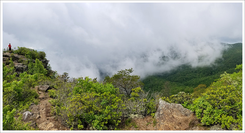
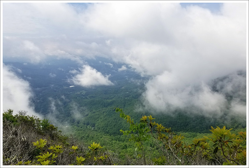
Around two miles, we reached the junction with the Pinnacle Trail taking off to the left. The good news is that the hardest part of the climbing is done. There is still more climbing to do on this spur trail, but it isn’t nearly as steep and some areas are quite flat. This section had some places where the trail was under water or extremely muddy due to all the rain, but I’m guessing is damp during lots of the year. After another 1.3 miles, the trail reaches the summit area. As we were hiking, we didn’t see any hope of the sun coming out, but we at least thought we could have a nice hike in the woods. Right before the summit, I decided to step off the trail a bit to urinate and as soon as I started, the sun came out. Christine got a big laugh since she thought this act had summoned the sun to appear (if you run into the same situation, it is worth a shot). So, we made a quick dash to the final summit area. The clouds were still preventing us from getting remarkable views, but we could see some views as the clouds were rolling over the summit path. We stopped here to eat a snack and take in the limited views. As soon as we packed up to leave, the clouds completely covered in everything so we lucked out. On our way back down, we ran into more hikers that were going up to the point. We almost felt like we were running on the way back down and it amazed us how steep the terrain was in parts.


Christine Says…
This hike was quite an adventure and a good cardio-challenge! The trailhead is located in Pinnacle Park, which is an 1,100 acre plot of land owed by the town of Sylva, NC and maintained by the Pinnacle Park Foundation. It used to provide the town’s watersource, but in the early 1990s it was put into conservation and opened for hiker access. The park has several backcountry campsites for backpackers. They ask that both dayhikers and backpackers complete a free permit form before beginning their hike. Blank forms are available at the trailhead’s informational kiosk.
When we arrived at the park (which is essentially just the dead end of the road), we had humid, foggy, drizzly conditions. The whole area was under the unsettled outer arms of Tropical Storm Alberto, so the weather was extremely changeable during our visit. We knew we had a big climb ahead of us, and really hoped the fog would clear off and let us have at least some views. It always stinks to climb and climb and climb, and then not even get a view. But, that’s the thing about these mountains – even when the valley is sunny, peaks over 4500′ often stay in the clouds and mist. You just never know what your summit weather is going to be until you get there.


After passing a gate, the hike starts off immediately and relentlessly uphill. The first two miles of the hike follow what seems to be an old forest service or logging road. It’s wide and covered with loose, round stones – a bit of an ankle-turner. In the first couple tenths of a mile, you’ll pass a stream with remnants of its history as a municipal water source. There are gauges and concrete channels that are now being reclaimed by nature. After that, you’ll make a wide switchback in a meadow. There will be a trail that comes in from the left. Stay to the right, climbing uphill, before eventually reaching a sign with trail mileage for the Pinnacle, Blackrock, and Waterrock Knob (on the Blue Ridge Parkway). Follow the trail toward Pinnacle. At a half mile into the hike you’ll pass Split Rock – an enormous cracked boulder right along the trail. The crack is big enough for an adult to climb in.
Shortly after the Split Rock, we had our first stream crossing. Even with the high water flow, all the stream crossings were safe and easy. I think I remember there being three crossings in the first two miles of hiking. The beauty of the stream along this trail is definitely something I’ll remember. I’m sure the water is not normally as impressive, but when we visited it was gorgeous – rapids and little waterfalls everywhere! Another thing I’ll remember from this hike is the CLIMBING! The first two miles ascend nearly 2,000 feet before moderating on the Pinnacle spur trail. It was definitely some of the steepest climbing we’ve done outside of New Hampshire. I guess the third memory from the hike is crossing paths with a Great Horned Owl! It swooped across the trail. That was an enormous bird – for a minute, we thought it was an eagle because it was so much bigger than any owl or hawk we’d seen before.


After climbing steeply for two miles, we were relieved to reach the junction with the Pinnacle Trail. It was a traditional trail instead of a wide road. It was very wet and muddy in a few places, but generally in good condition. It follows gentle rolling terrain for about a mile before a steep (but brief) descent into dense rhododendron. On the other side of the rhododendron, the trail exits out onto a large rocky outcropping at just over 5,000′. There are views (and precipitous drops) in every direction. We felt so lucky to have the clouds partially clear when we were at the viewpoint. What a gorgeous spot!
We spent some time enjoying the vista and a snack of trail mix before hiking back the way we came up. Shortly after we left the view, the clouds rolled back around us and we were hiking in the fog again. The hike back went really quickly because it was all downhill! By the time we got to the bottom, it was full sun and blazing hot. After packing up, we headed into Sylva for some barbecue at the Haywood Smokehouse (so amazing) and beers at Innovation Brewing. These two places are both on my ‘must list’ for this area.
Trail Notes
- Distance – 6.6 miles
- Elevation Change – 2,441 ft
- Difficulty – 4. The first two miles of climbing is relentless and steep. You’ll gain 1000 feet for each mile. Once you reach the junction with the Pinnacle Trail, the climb becomes moderate to flat.
- Trail Conditions – 4. The trail follows an old road grade for most of the way. The footing is a bit challenging with lots of football-sized rocks, but overall the trail is in great shape!
- Views – 5 – We visited on a day with lots of fog and moving clouds, but still had excellent views at the top.
- Streams/Waterfalls – 4. We visited after a time of extremely heavy rain, so the stream along the trail was simply spectacular. There were many small waterfalls and cascades to enjoy. The stream rating is probably not this high most of the time.
- Wildlife – 4. We saw a great horned owl swoop across the trail. There were also salamanders, a snake, and many small mammals.
- Ease to Navigate – 3. The first couple tenths of a mile of this trail are a little confusing, but if you keep climbing uphill, you’ll eventually come to a directional sign. After the directional sign, the trail is very clear and easy to follow.
- Solitude – 3. We saw just a few people out for the day.
Download a Trail Map (PDF)

Directions to trailhead: Parking is at Pinnacle Park in Sylva, coordinates: 35.422738, -83.191188

You did pick a particularly wet year for this hike. 2017 was much drier and colors that year were better than this year promises. Let’s see but looks like end of October before the leaf color will peak. My work on the area was pulled together in the 1994 Jackson County Proposed and Natural Heritage Areas. (NC Natural Heritage Program).
LikeLike