
Introductory Guide to Visiting the White Mountains
Mt. Kearsarge is located in state park land in Central New Hampshire with 360-degree spectacular views from the summit. On a clear day you can see Mount Washington, the White Mountain range, Merrimac Valley, and Vermont’s Green Mountains.
View the Full Album of Photos From This Hike
Adam Says…
Mt. Kearsarge kept popping up on lists of hikes we had not done in New Hampshire that had amazing views, so we decided to tackle it on a day where we could capitalize on the views. The hike starts off in Winslow State Park, reached by driving up Kearsarge Mountain Road and then taking a right on Winslow House Road to the top. The area at the top of the road is a large picnic area, with shelters and outdoor grills that would be perfect for a family gathering before or after the hike. The trail starts through an opening in the trees, near the southern back corner of the parking lot.
You quickly reach a large kiosk that shows the split of the loop trail. We took the Winslow Trail up and returned via the Barlow Trail. The Winslow Trail was quite steep and led through a lot of trail that was filled with lots of roots and rocks. If you do this hike after a lot of rain, expect it to be quite slick in some spots. The trail had us going a bit slow since it was a steep trail that required you to watch your foot placement in order to not twist your ankle.


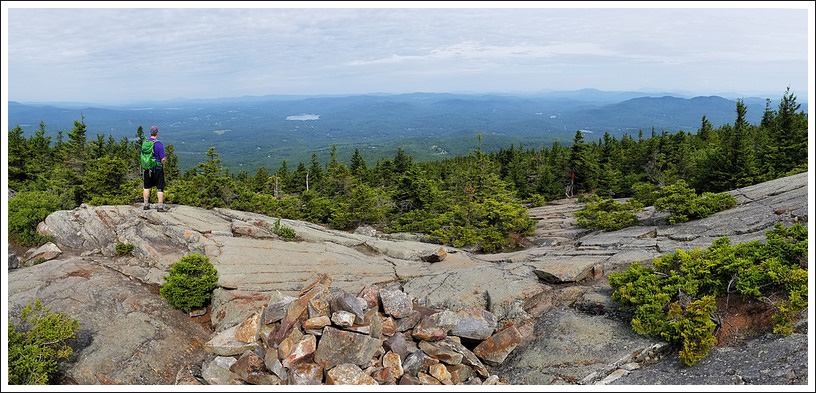
The trail then passed a large split boulder on the left around .8 miles. We were able to climb up to the top of this rock and then look behind us which opened up some views that were getting near the top of the tree line. At .9 miles, we reached the top junction with the Barlow Trail and we pushed on from here to reach the top shortly after at the one mile mark. The tower was in the middle of the huge rock expanse, but there were views all around. We took some time to enjoy the views all around. Fairly soon, we were joined by a few other hikers that had approached the summit via Rollins State Park – this is a shorter hike to the top of Mt. Kearsarge. We first talked to a woman with her great niece. The niece was probably about 11 years old and was not a fan of the hike or views. She didn’t want to even look at the views. She just wanted to know if she could touch the rock and leave immediately. I could tell the great aunt was disappointed that her niece didn’t enjoy nature like she did, which was disappointing to witness. The next person was a young woman from New Jersey that came here to do a quick day hike. She had also approached from the Rollins State Park side, but she was hoping to make a larger loop and ended up adding the Winslow and Barlow trails to her day.
We then went to the fire tower. Christine decided to climb to the top, but when I felt the rickety nature of the structure and was nearly hit by squirrel droppings from a squirrel that Christine had upset, I decided to just wait at the bottom. Some men soon arrived to do some maintenance work on the dishes and they were talking about some of the mountain ranges around us. While I am sure they are doing some hard work, I was envious wishing I had an office view like this one.

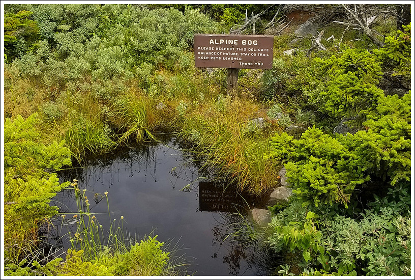
We made our way back to the junction at the edge of the treeline with the Barlow Trail and followed the yellow blazes for this way back down. We continued along the top as we walked by an alpine bog and then to some other views. Dragonflies were everywhere at the top and it was neat to see so many of them at this high elevation. We were glad we did the loop the way we did since we had views ahead of us on the way down. The trail had some steep sections going down but weren’t nearly as treacherous as the way up. Most of the trail was deep in the woods, but it was pretty scenery all around us. We eventually made our way back to the lower junction between the Winslow and Barlow trails at 2.6 miles and then took a quick turn to the parking lot and we were done. While the trail was a shorter one at 2.7 miles, the hike up took longer than we would have normally taken and the views at the top will make you want to take a large break to take it all in.
The books we had read and internet research we had done in advance probably didn’t give this hike enough credit. This is definitely one to hit while in New Hampshire. The length of the hike may also make it suitable for a lot of families and there is a wonderful picnic spot where you park to make this a memorable experience for the entire family.


Christine Says…
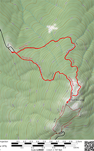
Mt. Kearsarge was our first new hike in New Hampshire during our summer 2018 trip. The small, but prominent, mountain is located in the Dartmouth-Sunapee region. Geologically, the mountain is what is known as a monadnock – a mountain that rises steeply and abruptly from relatively flat land. This type of mountain always looks taller and more imposing than it is in reality. It was a fantastic choice for an easy morning hike – great views, fun terrain, and not too lengthy. We chose to ascend on the Winslow Trail and then come back down on the Barlow Trail, making a 2.7 mile loop.
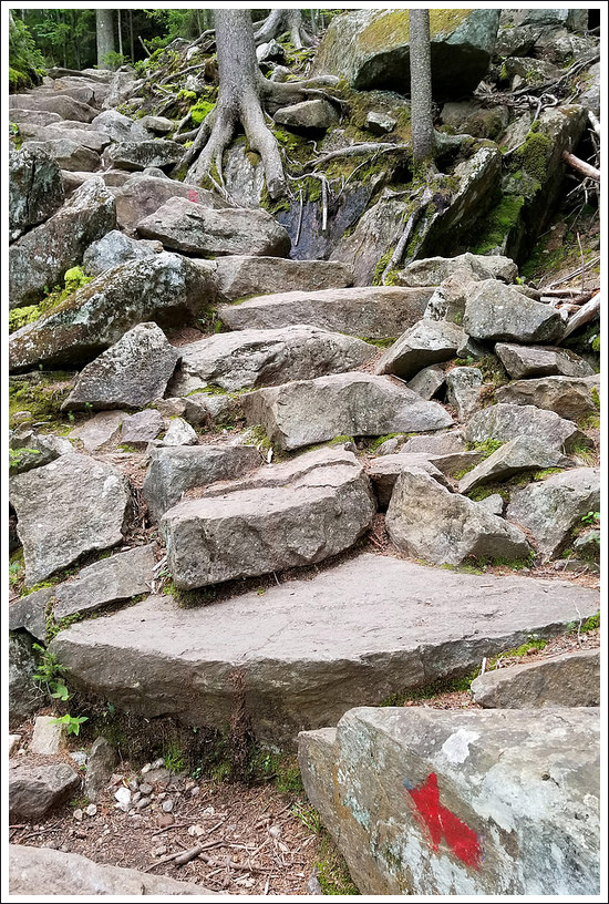
The Winslow Trail is shorter and quite a bit steeper than the Barlow Trail. I always think it’s nice to tackle the tougher terrain when my legs are fresh. I also appreciate the challenge of a tough climb. Upon entering the woods, the trail is soft and covered with pine needles. However, the trail footing soon becomes rooty and rocky. Red blazes will help you navigate across jumbles of boulders and granite slabs.


Your first views from the mountain come from atop a huge split boulder right before you break the treeline. This is also where the junction with the Barlow trail is located. You’ll pass the junction at this point and make your way toward the summit. In the bald, open area, cairns are used to guide hikers to the top. The park has posted several signs imploring hikers NOT to build new cairns. Moving rocks disrupts nature and building new cairns can make wayfinding confusing for hikers.
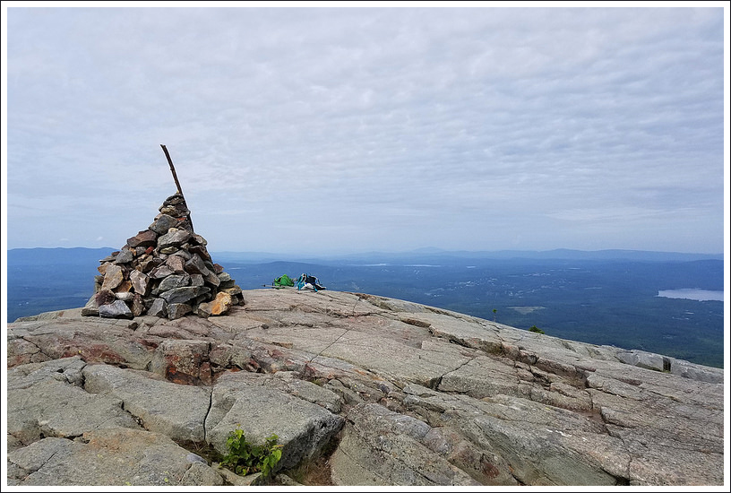
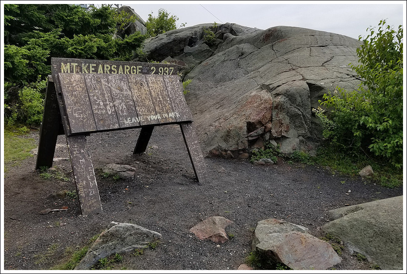
The summit of Kearsarge is marked by a big rockpile. From the top, the view rolls out in every direction. It’s GORGEOUS! When sky conditions are clear you can see the imposing White Mountains and Mt. Cardigan to the north, the Merrimack valley to the south, and to the west are Vermont’s Green Mountains. Just below the summit, the vista is interrupted by an old fire lookout and a communications tower. There is also a picnic area and a sandwich-board sign noting Kearsarge’s elevation (2,937’).


While the towers aren’t pretty, they barely detract from the magnificent views in every direction. I climbed the tower while Adam hung out below. On my way up the stairs, I encountered a very angry red squirrel. I thought he was going to dive-bomb my face, but he settled for loud chattering. The view from the tower wasn’t really any better than the view from the summit, so I made my way back down and found a nice rock to sit on.
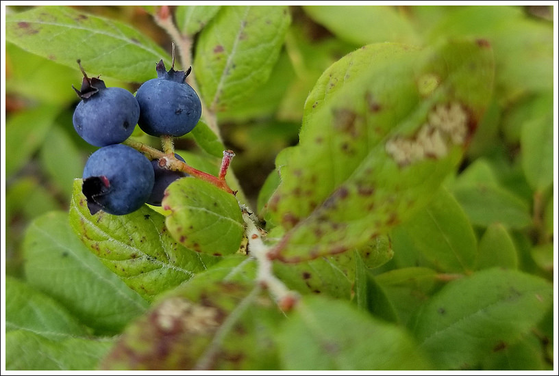
After taking in summit views, we made our way downhill to where the Winslow and Barlow trails meet. The yellow blazed Barlow Trail passes across open areas with more stunning vistas. We saw blueberry bushes and a small alpine bog on our way down. When we visited, dragonflies were swarming the mountain. If you look closely at our photos, you’ll see loads of them!
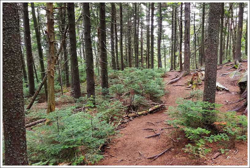
Eventually, the trail will traverse some slab granite and dip back into an evergreen forest. The trail continues downhill over roots and pine needles. There is one small footbridge over a swampy area near the end. The trail ends at the initial Winslow-Barlow junction near the picnic area at Winslow State Park.


Trail Notes
- Distance – 2.7 miles
- Elevation Change – 1224 feet
- Difficulty – 3. The trail was steeper than we would have expected, but take your time.
- Trail Conditions – 3. Due to the steepness and the abundance of roots and rocks, this could make for a more difficult hike after heavy rainfall.
- Views – 5. 360-degree views all around from the summit. There is a fire tower that obstructs some of the view but you can rotate around it to take it all in.
- Waterfalls/streams – 0. Non-existent.
- Wildlife – 2.5 A decent spot for bird-watching and squirrels.
- Ease to Navigate – 4. The trail was fairly well-blazed. The junctions may make things a bit tricky, but follow our map.
- Solitude – 2. This is a popular spot and with two approaches to the summit, you may not realize how many people you may see at the top. You should be able to carve out your own solitude at the top since there are views all around.
Trail Map
Elevation Profile:

Directions to trailhead:
Coordinates for this hike are 43.390281, -71.868260. The trailhead is located in New Hampshire’s Winslow State Park in Wilmot, NH. There is a fee to enter the park.

I miss New Hampshire. If you ever get the chance, I recommend the other Kearsarge as well – the one in the White Mountains.
LikeLike
We thought about doing that one as our final hike of the 2018 trip, but it was just too far of a drive for the last day of vacation. You spend a lot of time driving *around* mountains in New Hampshire!
LikeLike
I hiked up here with my brother when he lived in NH a number of years ago. It is a beautiful hike. He was giving me a ride to Maine and we decided to do one last hike together here. I remember a couple of maintenance men carrying a huge antenna up on their back!
LikeLike
Neat to see the antenna carried up!
LikeLike