
Introductory Guide to Visiting the White Mountains
Note: We’ll be taking you to New Hampshire for our next seven hikes! Enjoy the north country!
This 5.3 mile hike includes open ledges, ladders up cliff faces, caves, tight squeezes, and rock scrambling. At the summits of both Morgan and Percival, you get great views of Squam Lake. Look for blueberries along the way!
View the Full Album of Photos From This Hike


Christine Says…
After two lengthy days of travel from Virginia to New Hampshire, the last thing we wanted to do was get back into the car for more than a short drive. So, for our first hike in the area, we chose the Mt. Morgan – Mt. Percival Loop. The 5.3 mile hike is just a few minutes from my parents’ house and offers great views of Squam Lake.
We hiked this loop in 2009, before we started including out-of-state hikes on Virginia Trail Guide. I remembered only a few generalities about this hike: challenging, exceedingly buggy, nice views, tons of blueberries. It definitely seemed worth another look!
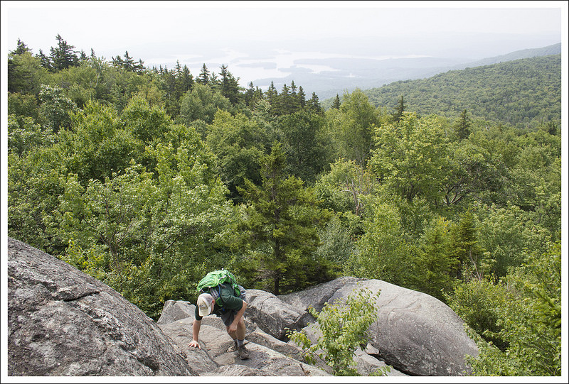
By New Hampshire standards, this trail is rated moderate. On paper, that seems fair – 5.3 miles and 1,575 feet of climbing. But, by Virginia standards we probably would rate this hike more toward difficult due to the terrain. If you follow the route as we hiked it, there are ladders, exposed ledges, steep rock scrambles, and a tight-squeeze section that passes through a series of caves. It’s also very muddy, rocky and rooty. I would equate the skill-level/fitness needed for this hike to be similar to what you need to hike Old Rag.

We started off early in the morning, but the parking lot was already full when we arrived. We managed to wedge into one small space still remaining in the corner of the lot. I think most of the cars parked in the Mt. Morgan lot belonged to people hiking the Rattlesnakes on the other side of the road, because we saw relatively few people on our hike.
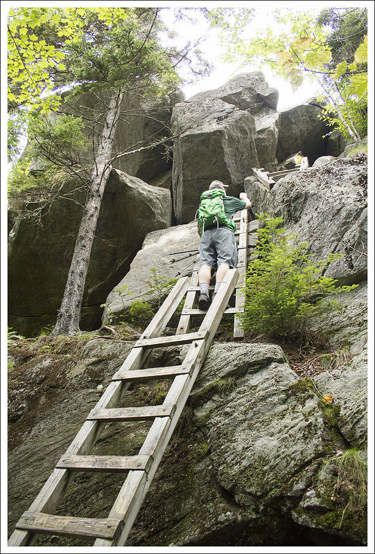
The Mt. Morgan trail started off at the end of the parking lot. The path was wide, gradually ascending, and covered with pine needles. There were beautiful, papery white birch trees all through the woods. As the trail continued, the climbing got rockier and steeper. We passed sections of old stone wall half buried in the forest. There were also several muddy stream-bed areas to traverse. At 1.7 miles, the Mt. Morgan trail and the Crawford-Ridgepole trails joined ways for about .4 miles before reaching a series of ladders affixed to a cliffside.
If you’re not into height and ladders, you can continue on the Mt. Morgan trail for several tenths of a mile to reach the summit. We chose the ladders. I did fine until there was a horizontal move from one ladder to another, followed by a step onto a large metal screw in the rock. I kind of panicked at that point because I couldn’t span the space with my arms. I could get my feet where they needed to be, but I couldn’t reach any solid handhold to pull myself up the rock face. Adam ended up giving me a hand up. We both passed through a small cave onto a steep, exposed ledge with views of Squam Lake. After enjoying the view for a moment, there was still a little more steep, scary boulder scaling we had to do to get to the summit of Mt. Morgan. I stood on the ledge and pondered whether I wanted to go back down the ladders and go around, or figure out a way up the rest of the rocks. I ended up opting for directly up the rock face, but I paid a price for it. I got several huge bruises and two gashes on my legs from the sharp, hard granite. What can I say… I never go home from New Hampshire unbranded!


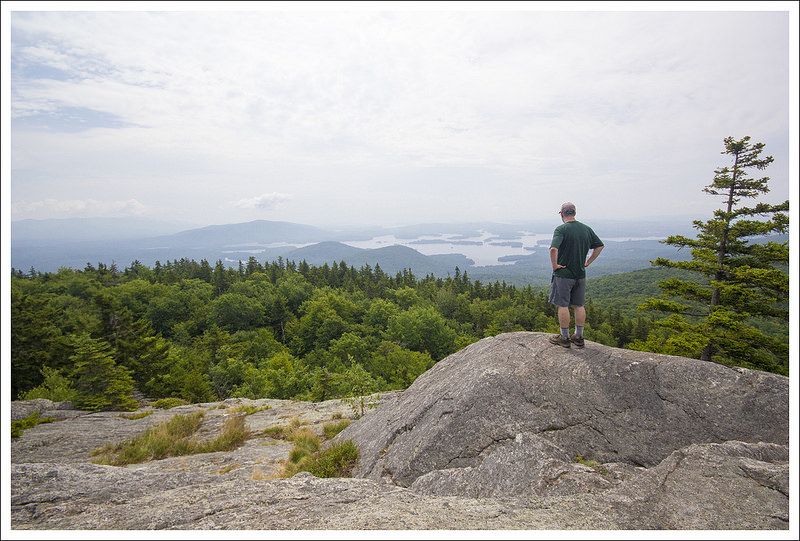
The view from Morgan was lovely, albeit misty and hazy on the day we visited. There also weren’t as many blueberries as I remembered. We had a snack, took a few photos and pressed on to the next summit – Mt. Percival.
We followed the Crawford-Ridgepole trail for about .9 of a mile to the summit of Percival. The trail across the saddle between the two mountains was alternately rocky, boggy and piney. There were a few steep spots, by this section of trail was one of the easier parts of the hike.
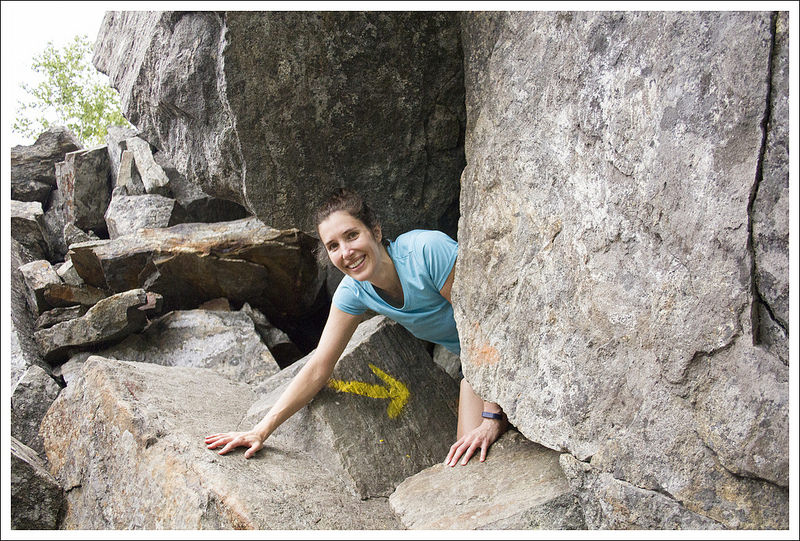
Right at 3 miles, we reached the summit of Percival. The view was similar to that of Morgan – Squam Lake’s asymmetrical, island-dotted expanse. At the summit of Percival, there are two sets of blazes – one to the side and another that plunges steeply right of the front of the mountain. When we visited, there was no sign indicating where each trail headed, so we used our guidebook and map to make a guess. If you take the trail on the side, you’ll have steep (but normal) climb down the Mt. Percival trail. If you follow the blazes over the cliff, you’ll find yourself wedging your body through a series of caves and opening in boulder tumbles. The cliff route is fun and a little bit unnerving.
There were several places that Adam and I looked at each other and thought NO WAY! We had to pass backpacks and trekking poles through openings. There was even one place I thought I’d make it, but my backpack got hung up and left me stuck! After several squeezes, we came to the junction of the Mt. Percival Cliff Trail and Cave Trail.
After this point, the rest of the climb down Mt. Percival was just a steep, rocky, rooty, slippery, muddy knee grinder. I didn’t particularly enjoy this part of the hike. My knees and feet were hurting and I was being relentlessly menaced by bugs. It’s hard to pay attention to your footing when you’re flailing your hands to swat flies away from your face. I definitely slipped and slid several times.


I was pretty happy when, at 4.7 miles, we reached the junction with the Morse Trail, because it meant the hard hiking was behind us and we were almost back to the car. We flew along the Morse Trail, enjoying pretty streams and easier footing. We made one final left turn back onto the Mt. Morgan trail for the final tenth of a mile.
After wiping off the mud and doing a little minor first aid, we were on our way to a well-deserved lunch at Squam Lakeside. They have enormous lobster rolls and sherbet freezes. It’s a great place to eat outside and enjoy a view of the lake.
Adam Says…
This was one of those trails that I first discovered five years ago when I was researching nearby geocaches when we were visiting the White Mountains for the first time. I was also drawn to Mt. Percival due to my love for reading Arthurian legends when I was younger (Percival accompanied Sir Galahad on his quest for the Holy Grail). I remember this being a challenging hike, yet unlike anything we have in Virginia. As a hiking couple, we sometimes find that one of us enjoys a hike more than the other; we also face days where one of us is not having a strong hiking day. This hike was one that I enjoyed more than Christine. For me, if I experience something unusual on a hike (a rock scramble, ladders, exposed cliffside walks, a stream crossing where we have to wade across), I find that I really have fond memories of it. As I’m reflecting, I realize I enjoy the challenge of trying to figure out how to overcome an obstacle. This loop definitely has some of those memorable abnormalities on it.

We were looking for a decent hike to start off our trip to the White Mountains. Since we had about a 12 hour drive from our home in Virginia to New Hampshire, we were looking forward to doing something active. We found the parking lot and trailhead along Rte. 113. The trail starts off level and at .1 miles, you reach the junction with the Morse Trail, your return route for the loop. Stay straight on the Mount Morgan Trail. The trail starts off with a gradual uphill, but the trail begins to get steeper and rockier as you continue. There wasn’t a lot to note on the hike up, but the sight of white-barked birch trees always makes me happy to be in New England. At 1.7 miles, you reach a junction with the Crawford Ridgepole Trail. Stay on the right to continue your hike up to Mt. Morgan. At 2.1 miles, we reached a sign that shows that you can reach the summit of Mt. Morgan through the ladders or circumvent and reach the summit by continuing on the trail.
During our first visit in 2009, I had decided to go up the ladders and Christine went the other way. In 2009, never having experienced ladders attached to large rocks before, I was very apprehensive and worried about climbing up that way. But when I saw an older man climb the ladders without any difficulty, I dug deep and forced my way up them. This time, I didn’t have any trepidation, most likely from the combination of climbing these ladders before and experiencing more harrowing ladder climbs at Grandfather Mountain in North Carolina. Once we reached the top of the ladders this time, we had some rock scrambling to do up some exposed rocks until we reached the summit of Mt. Morgan. I was proud of Christine tackling the ladders and the rock scramble, because these are definitely things she doesn’t usually enjoy.


We had a hazy day from the summit of Mt. Morgan, but the view over Squam Lake always amazes me with the small islands scattered through the lake. We climbed down from the summit and shortly reached the sign which pointed out the other option for reaching the Mt. Morgan summit. We continued on the rocky trail, which is fairly flat on the ridge, but does have some ups and downs as you are climbing over rocky areas of the ridgeline. At 3.0 miles, we reached the summit of Mt. Percival. The summit of Mt. Percival was very hazy and cloudy, which didn’t give us great views this day, but we remember the great views we had from here in 2009. The signage at the summit of Mt. Percival didn’t help us too much. We saw two sets of blazes leading down the mountain, but there was no signage stating where they headed. After consulting my map, we took the rightmost trail (facing the view) that seemed to lead straight down the rocks. It turns out this is the option to go down via the caves (the next trailhead down to the left of this one would be more of a cliffside trail but they join ahead). We climbed down this very steep section and then at one point, I said “You’ve got to be kidding me. How are we getting through that?” The trailblazes led down into a hole that wasn’t much bigger than my body.
This turns out to be the entrance to the cave on this trail. You can still see light shining through in spaces between the rocks, but it is fairly closed off and not a route for any claustrophobic people. We rock scrambled through the cave and then eventually the blazes lead you out of the cave through another hole not much larger than my body. When I peered through this opening, I couldn’t see what was ahead, but I plunged my body through and I felt like I was getting reborn through a rocky birth canal. On the other side was a family heading up, so we had to exit before they could try to enter. We made our way through and then had a little more downhill rock scrambling to do until we reached another sign. This one pointed the way to the summit via the cliffside trail or through the caves. This would have been helpful from the summit.


The trail at this point continued its rocky climb down and you can hear the sounds of Smith Creek at times. Eventually at 4.7 miles, we reached the junction with the Morse Trail, that ducks to the right. We took the Morse Trail, which was mostly flat but more overgrown and less traveled than the other trails. This trail joins the Mt. Morgan again at 5.2 miles. We took a right and made our way back to our car in just another .1 mile.
At the summit of Mt. Percival, we met a girl hiking with her dog. She was also trying to figure out which way led down Mt. Percival and she took the cave trail as well. I can’t even imagine how she navigated her dog through the caves, but we saw her at the junction with the Morse Trail. She told us how tough it was for her dog. She was training for her goal of trying to hike the 48 peaks of New Hampshire that are above 4000 feet with her dog. This goal has been most popularized by the book Following Atticus by Tom Ryan and you can read more about their adventures on his blog.
There are several geocaches along this trail:
- Mount Morgan Surprise – earthcache
- Mt. Morgan cache
- King Arthur’s Knights
- The Peak of Percival – earthcache
- Percival II – Le Presse-citron
- Easy Rider
- X-Calibur
- In the Realm of the Blue Knights

As we are always trying to cover new ground whenever possible, I’m not sure how often on our return trips to the White Mountains we will revisit this loop, but this is definitely a hike that you will remember. The interesting features and scenic views give you an introductory glimpse into what hiking is about in New Hampshire.
Trail Notes
- Distance – 5.3 miles
MapMyHike Stats * - Elevation Change – 1575 feet
- Difficulty – 4.5. Even with a moderate elevation gain and distance, the terrain of this trail warrants a higher difficulty rating.
- Trail Conditions – 3. The trail was a muddy, slippery mess when we hiked, but generally the trail is well maintained and passable.
- Views – 4. On a clear day, the view of Squam Lake is beautiful.
- Waterfalls/streams – 2. There are lots of small streams and springs on this trail. Nothing mind-blowing (and a lot them just make mud), but a couple crossings along the Morse Trail are pretty.
- Wildlife – 1. We saw red squirrels and a salamander.
- Ease to Navigate – 2. There are multiple trails that lead the same place. Also, there isn’t a sign differentiating the cave and cliff trails on Mt. Percival.
- Solitude – 3. This trail is not as popular as the nearby Rattlesnakes, but you’ll probably still see a number of hiking parties along the way.
Download a trail map (PDF)
Directions to trailhead: From I-93: Take Exit 24 and follow Rt. 3 South to Holderness. From the town Holderness, get on Rt. 113 and follow it northeast for about 5.5 miles. Parking will be in a gravel lot on the left. The large parking lot on the right is for the Rattlesnakes hike. If there is no space left in the Morgan lot, it is fine to park at Rattlesnakes.
* MapMyHike is not necessarily accurate, as the GPS signal fades in and out – but it still provides some fun and interesting information.

Two of us went yesterday (2014/11/23) to Mt. Percival then to Mt. Morgan. It rained the previous day. There were icy spots at higher elevations. It was worse going up to Mt. Percival then down from Mt. Morgan. We were pondering at the summit which way to go down since we knew it was icy up to Mt. Percival and we heard it was icy and people back off from going down through the ladders. It turns out the ladders weren’t so bad as long as you handle it with caution. The trail was much easier to manage once you pass the 1st 10 min down from Mt. Morgan. It was a nice hike and I believe the trails are manageable by most averagely-experienced hikers. – Ed
LikeLike
Thanks for the visit and comment, Ed! I think I’d be pretty scared to do that hike in icy conditions!
LikeLike