Pets ARE NOT allowed on this hike
This 5.6 mile hike offers a great scenic viewpoint, a cool rock formation to explore, and a chance to stroll around historic Shrine Mont. While the hike is generally moderate, almost 1,150 feet of the the ascent occurs in just over a mile of trail.
View the Full Album of Photos From This Hike
Download a Map of All Trails Around Shrine Mont


Adam Says…
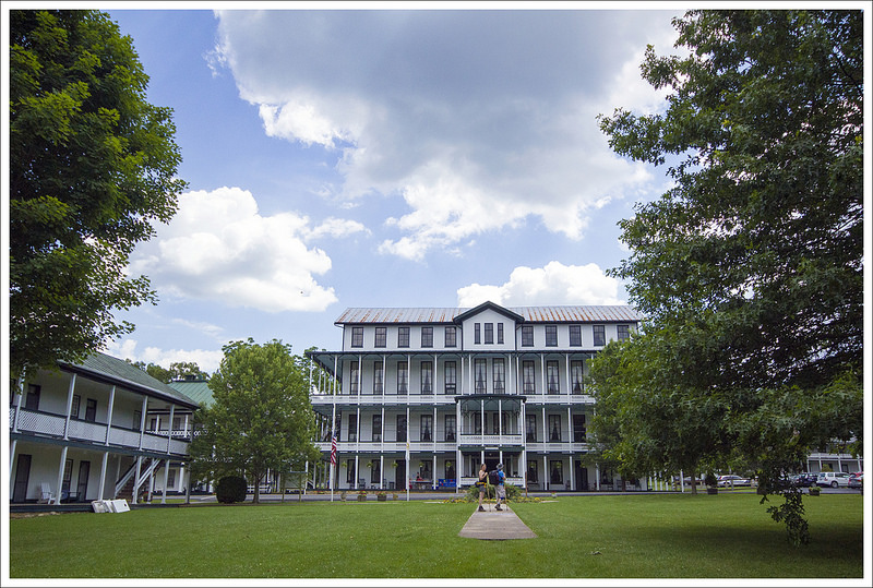
Tony and Linda from Hiking Upward had suggested we tackle this hike together from Shrine Mont. We met up on the porch of the Virginia House. Since Christine and I got there a little early, we went inside this main lodge building and found a copy of their trail map at the front lobby. Most of the people there were there for a church retreat. When we got together, we walked down the road and found a sign directing us to the shrine. We walked up to the shrine, which was a cute outdoor chapel made of stone, reminding me of an old historical spanish mission church where the congregation would meet up in an outdoor location to worship.
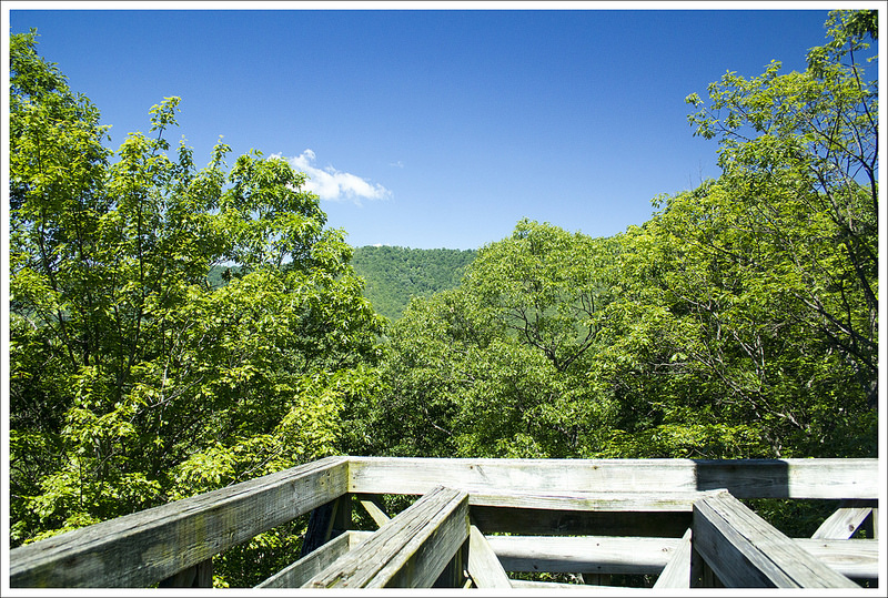
At the shrine, you will see a kiosk and sign pointing to the cross and north mountain, which will start the main hike. Along this part of the trail, you will pass by signs along the way that depict the Stations of the Cross. The trail leads along a side of a large hill. Once the trail switches back, you arrive at the large cross and Cross Observation Deck at 1.1 miles. You can climb up a few flights to an observation deck. We were hoping for a nice view at the top – maybe there was at one time, but the overgrown trees have taken away most of the view.


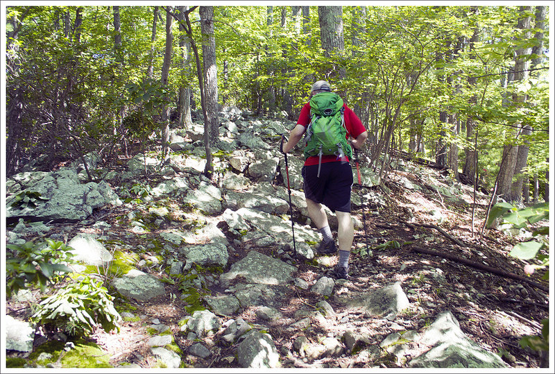
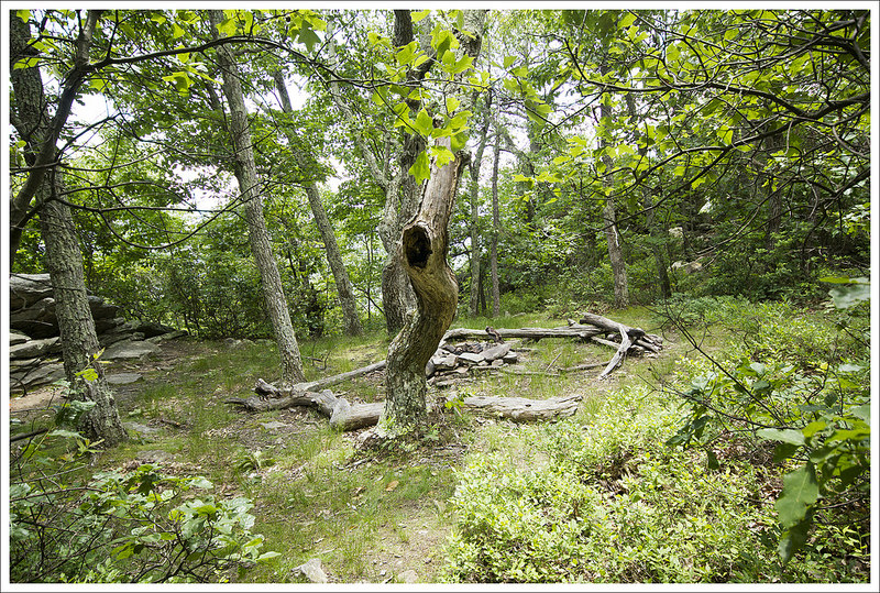
Continuing along, the trail walked a ridgeline for a short time before descending again. At 1.75 miles, we reached a junction and took a left to start the trail up North Mountain. You quickly pass a forest road and at 1.85 miles, you will arrive at another junction (the Bradford Trail branches off to the left). Stay straight on the North Mountain Trail, which follows a gravel road for a short distance, before turning left to stay on the trail. The trail is a constant uphill from this point, with some of the trail being quite rocky and steep. Around the 2.6 mile mark, we reached a large cliff. I decided to explore a little further and found on the left side of the cliff, there was a way up that allowed me to walk along the shelf of the cliff as the rock sloped upward. Of course, I wasn’t the first to get this idea as I found a fire ring and lots of graffiti on the cliff shelf. I could see this being an interesting spot for rock climbers.
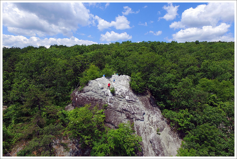
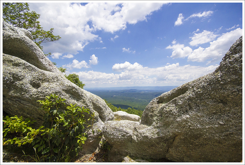
We jumped back on the trail and continued our climb up. The trail was very steep and rocky in some of these next sections, making for a slow pace to the summit. Eventually, you will skirt an edge where you get some obstructed views along the way and you won’t have much further. We eventually made it at 3.3 miles to a campsite and the summit. When you arrive, you will be at the back side of the views. Go around to the right of the rocks and you will find some rocky ledges that you can climb up about 15 feet to get to the shelf of rocks for an outstanding view. This climb up the rocks should only be done if you feel comfortable and I wouldn’t recommend this for families. Once you climb over the top, you are on a sloping downward piece of rock covered with some slippery lichen. There is a small area that you can sit and enjoy the views, but could be hard to accomplish if a lot of people are at the top at once.
Tony had brought along his drone to try and get some good photos of the scenery around us. I helped him launch it and it got some great shots of us and the views all around. When Tony was bringing it back in, he mixed up the controls and it came crashing down on the rockface and into the trees below. We both made a path along the side of the rockface and scrambled through a ton of briars to retrieve the drone. It turned out that it was still operational and we enjoyed watching the video of the crash and retrieval.
We made our way back down retracing our steps for most of the hike. At 4.85 miles, when we reached the junction that would have led us back to the Cross Observation Deck, we instead stayed straight and followed the signs back to Shrine Mont. The trail winds back down the mountain and goes behind some of the cabins of Shrine Mont. We got back to the main road and the parking area at 5.6 miles. We took a few minutes to explore the Shrine Mont area before making our way on to Woodstock Brewery for some food and drinks.


Christine Says…
We always enjoy a chance to meet up with our friends from Hiking Upward. Tony and Linda suggested meeting at Shrine Mont and hiking to a rocky outcropping on Great North Mountain.
We thought we were doing an easy 3-4 mile hike, but it turned out to be a bit longer and much more challenging than expected. I think most of the challenge was due to two factors: 1) the heat/humidity and 2) most of the ascent was stacked into just a mile and a half of the hike.
I got my first hint that I wasn’t going to have an easy day on the trail when we started climbing to the Cross Observation Tower. The trail to the cross is short but fairly steep. I trudged along, thinking to myself ‘I feel really hot. I’m sort of lightheaded. I hope I don’t barf!’ By the time we got to the cross, I had to sit down and cool off. This was one of the first really hot and sunny days we hiked this summer and I just wasn’t used to it. It didn’t help that my Camelbak was full of <gag> tepid tap water.
For a while after the tower, the way was easy going. The trail was moss-covered and followed a gentle grade. We heard millions of cicadas singing in the trees. It was a constant, other-worldly static sound. We saw a few of the large insects clinging to branches, dead on the ground, or buzzing lazily around in the air. One of them even flew right into my face and bounced off my forehead. I was too hot to care. I didn’t even manage a half-hearted swat.


Eventually the Ridge Trail intersected with the North Link Trail. We followed that for a short distance to the North Mountain Trail. At first the North Mountain trail was deceptively easy. I was feeling better and cooling off. Then the trail started getting rockier. We had to constantly watch our footing on the shifty rocks beneath our feet. After a couple tenths of a mile, the trail started to climb rather steeply uphill through stands of dense mountain laurel and rhododendron. It felt close – the air was sweltering with no hint of a breeze. I started to feel woozy again. Eventually, we reached the towering cliffside/cave in the middle of the woods. We all took a break, cooled off, and some time to explore the rock formation.
After the break, the climbing got even steeper. I’d hike a quarter mile and then need to rest. I almost never take breaks unless there is something interesting to see. In this case, I just thought it would be interesting not to pass out. I found myself sitting on the ground with my head between my knees. I was so hot – I felt like a furnace was stoked up in the core of my body. The lukewarm water in my pack wasn’t doing anything to cool me off. So, I took lots of breaks and trudged until we finally reached the ridgeline. At that point, the climbing moderated and we only had a few more tenths of a mile to go. But, we were also in more direct sun, so it was even hotter. Adam was really the only one of us hiking at a quick pace. Tony and Linda were behind me a bit, and I kept watching the space between Adam and I get bigger and bigger. I started seeing stars, and proclaimed to nobody in particular ‘I NEED TO SIT DOWN NOW OR I WILL PASS OUT!’ In a minute or two, Tony and Linda caught up and Linda poured ice water on my neck and head. They were both hiking with frozen bottles of water and Gatorade.
After another rest, I was able to make the final push to the summit and its rocky outcropping. I scrambled to the top of the rock and found a nice breezy spot to lie down and enjoy the magnificent view. I ate a Larabar and watched Adam and Tony play with (and crash!) the drone. After a pleasant stay at the top, we made our way down. The downhill hike was much faster and easier, and I felt completely normal again. I’m not sure why I struggled so much with this hike. Yes – it was hot and the climbing was stacked into one small section, but I’ve certainly done harder hikes on hotter days. The only thing I can guess is that I was fatigued from doing a lot of hiking in the days leading up to the Shrine Mont hike. I’d done a 16 mile, a 4 mile, and an 8 mile hike and was already pretty depleted. In the hikes since this one, I’ve started making gigantic ice cubes for my Camelbak. I have plastic mason jars that I fill and freeze. The jars are just small enough that they just fit through the circular opening in the bladder, but they’re big enough to not melt quickly.


Our hike down followed the same route we came up for most of the way. We were planning on turning onto the Bradford Trail, which would have added another mile or two to our hike. But everyone was hot, tired, and thinking about beer – so we opted to follow the much shorter route down the North Link Trail back to Shrine Mont.
We got back to the cars, cleaned up, and made our way for an afternoon at Woodstock Brewery. They had excellent barbecue and we all enjoyed their vanilla porter.
Trail Notes
- Distance – 5.6 miles
Check out the stats from Map My Hike* - Elevation Change – 1545 ft.
- Difficulty – 4. Some of this trail is quite rocky and steep making for a hard climb at the end.
- Trail Conditions – 3.5. The trail was well-maintained and traveled with very few blow-downs, but the rocky terrain makes for some tough steps.
- Views – 4. If you aren’t bold enough to climb up the rock outcropping, this score would be a lot lower. You are treated with a nice panoramic view if you do.
- Streams/Waterfalls – 1. There are some small stream views, but nothing substantial.
- Wildlife – 1. This is a popular trail, so wildlife tends to stay away.
- Ease to Navigate – 2.5. The trail system is tricky. Some of the junctions are not well-marked and labeled on the printed map. Download both of the maps from this page and you should be fine. On our way back, there were several options leading down to Shrine Mont, which could bring some confusion as well.
- Solitude – 3. We ran into some people that were staying for a retreat as well as locals.
* MapMyHike is not necessarily accurate, as the GPS signal fades in and out – but it still provides some fun and interesting information.
Download a Trail Map (PDF)
Directions to trailhead: Coordinates for parking are 38.795500, -78.815932
From Woodstock, VA, head southwest on VA-42 for 13.8 miles. Turn right on State Route 720 and in .7 miles, stay straight to join State Route 721. Go 1.5 miles and then stay straight (right fork) to join State Route 722. Go .5 miles and turn right on to VA-263West. Follow this for 3.7 miles and it will lead to Shrine Mont. Park in the parking lot behind the pavilion and the main Virginia house. Walking from the parking lot, take a left at the main road walking in front of the Virginia house and follow the road until you see signs directing you to the Shrine.

Beautiful place. I have been there on Winter month and went on last Saturday (8/4/18), the trail was stream like condition since there was a rain before our hike. The waterproof boot is recommended if there was rain on previous day/s.
LikeLike
I’ve never heard of this place, and now I’m itching to see if it’s good for climbing! Carderock and Great Falls are both pretty crowded.
LikeLike
Oooh, so glad you wrote this up. Recently bought a place at Bryce and love checking out Shrine Mont but haven’t been up to the rocks yet.
LikeLike